Getting There Quicker with Geospatial Technology
244
Vehicle Navigation Systems, Road Maps in a Digital World,
Creating a Street Network, Geocoding, Shortest Paths, and
Street Networks Online
vehicle navigation system a device used to plot the user’s position on a map, using GPS technology to obtain the location
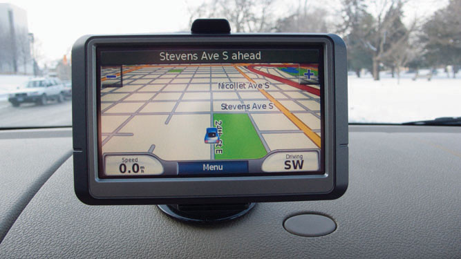
Vehicle navigation systems (the kind of devices made by companies like Garmin, Magellan, or TomTom) are really revolutionary technologies. One small device mounted on the dashboard will find your precise location, plot it on a map, determine where the nearest gas stations are, then compute the quickest route to get you there—all with turn-by-turn directions that announce the names of streets and the distance to the next turn (Figure 8.1). Many smartphone apps can do the same things, effectively turning your phone or mobile device into a satellite navigation system. The position determination is straightforward—the device has a GPS receiver in it that finds your location on Earth’s surface, using the methods we discussed in Chapter 4. In fact, most people who own a device with a navigation system simply refer to as a “GPS,” as in “Punch our destination into the GPS” or “What does the GPS say is the shortest route to get there?” However, it’s doing a disservice to these things to call one of them simply a “GPS” since it’s obvious they do so much more than what a regular GPS receiver does.
These devices rely on a GIS-style system at their core—hence their ability to handle spatial data in the form of road-network maps, to use those maps for routing, to determine the shortest path between two (or more) points, and to match an address to a spatial location. This same type of data is used to route emergency vehicles to the site of a 911 emergency phone call or to manage a fleet of delivery vehicles. You’ll find the same sort of system at the heart of online mapping applications such as MapQuest or Google Maps, and in the location and mapping apps of a smartphone. This type of technology is changing fast and getting better at what it does.
245
!search! THINKING CRITICALLY WITH GEOSPATIAL TECHNOLOGY 8.1
What Happens When the Maps Are Incorrect?
How many times has this happened to you when you’re using some sort of mapping service—either the directions take you to the wrong place, or they indicate you should turn where you can’t, or they just can’t find where you want to go (or the road you want to go on)? When these things happen the GPS location is probably correct, but the maps being used for reference are likely either outdated or have errors in them. How much does the usefulness of this aspect of geospatial technology rely on the base data? For example, when Apple released its Maps component of iOS 6 in 2012, several location inaccuracies were reported, including the mislabeling of a supermarket as a hospital. If the base maps are incomplete or not updated, then how useful is a mapping system to the user?
It should also be noted that many vehicle navigation systems will recompute a new route on the fly if you miss a turn or start to take another route to your destination. However, if the system has taken you on an improper route, how useful will the system be in getting you back to where you want to go? A key purpose of mapping systems is to navigate through unfamiliar territory—but if they don’t properly fulfill that function, what can travelers rely on? Are there any sorts of liability issues that could result from inaccurate mapping and misleading instructions?
A March 2009 article in USA Today describes an incident where a vehicle navigation device instructed the driver to turn off a road and follow a snowmobile trail toward a destination—this ended with the car stuck in the snow and the state police being called for emergency help. Similarly, a March 2009 article of the Daily Mail relates a story of a vehicle navigation system that directed a driver along a footpath, which ended in a sheer drop of 100 feet off the edge of a cliff (luckily, the driver stopped in time). When errors like these occur, it’s usually not because the GPS receiver is finding the incorrect position from the satellite information. The problem is much more likely to be with the base network data itself. These types of systems are only as accurate as the base network data they have available to them. This chapter delves into how these types of geospatial technology applications function, how they’re used, what makes them tick, and why they may sometimes lead you astray.
246