Sea Roads: Exchange across the Indian Ocean
If the Silk Roads linked Eurasian societies by land, sea-based trade routes likewise connected distant peoples all across the Eastern Hemisphere. For example, since the days of the Phoenicians, Greeks, and Romans, the Mediterranean Sea had been an avenue of maritime commerce throughout the region, a pattern that continued during the third-wave era. The Italian city of Venice emerged by 1000 C.E. as a major center of that commercial network, with its ships and merchants active in the Mediterranean and Black seas as well as on the Atlantic coast. Much of its wealth derived from control of expensive and profitable imported goods from Asia, many of which came up the Red Sea through the Egyptian port of Alexandria. There Venetian merchants picked up those goods and resold them throughout the Mediterranean basin. This type of transregional exchange linked the maritime commerce of the Mediterranean Sea to the much larger and more extensive network of seaborne trade in the Indian Ocean basin.
Until the creation of a genuinely global oceanic system of trade after 1500, the Indian Ocean represented the world’s largest sea-based system of communication and exchange, stretching from southern China to eastern Africa (see Map 7.2). Like the Silk Roads, these transoceanic trade routes — the Sea Roads — also grew out of the vast environmental and cultural diversities of the region. The desire for various goods not available at home — such as porcelain from China, spices from the islands of Southeast Asia, cotton goods and pepper from India, ivory and gold from the East African coast, incense from southern Arabia — provided incentives for Indian Ocean commerce. Transportation costs were lower on the Sea Roads than on the Silk Roads because ships could accommodate larger and heavier cargoes than camels. This meant that the Sea Roads could eventually carry more bulk goods and products destined for a mass market — textiles, pepper, timber, rice, sugar, wheat — whereas the Silk Roads were limited largely to luxury goods for the few.
Page 292
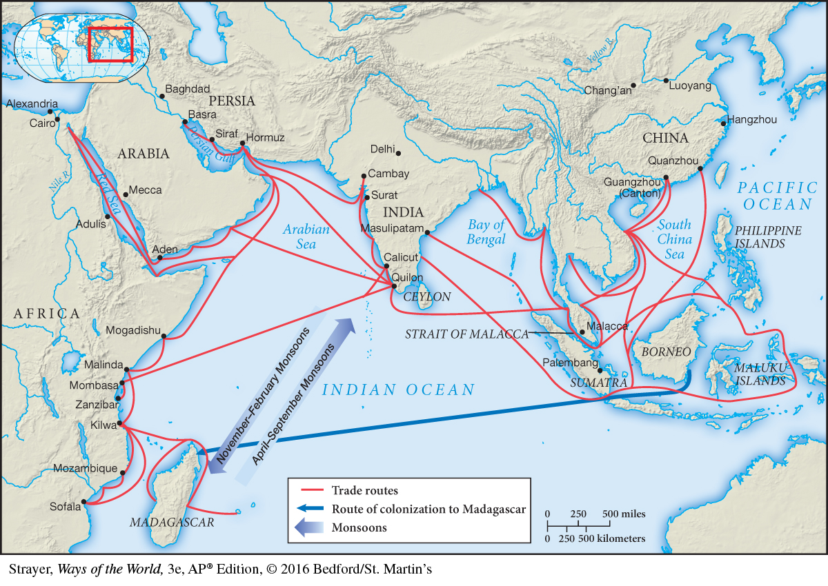
Figure 7.2: Map 7.2 The Sea RoadsParalleling the Silk Road trading network, a sea-based commerce in the Indian Ocean basin connected the many peoples between China and East Africa.
AP® EXAM TIP
Study the map on the opposite page closely. You must know the effects of the monsoon winds on trade in the Indian Ocean. You should also know that, like on the Silk Roads, people from many different societies participated in exchanges in the Indian Ocean network.
What made Indian Ocean commerce possible were the monsoons, alternating wind currents that blew predictably northeast during the summer months and southwest during the winter (see Map 7.2). An understanding of monsoons and a gradually accumulating technology of shipbuilding and oceanic navigation drew on the ingenuity of many peoples — Chinese, Malays, Indians, Arabs, Swahilis, and others. Collectively they made “an interlocked human world joined by the common highway of the Indian Ocean.”7
Page 293
But this world of Indian Ocean commerce did not occur between entire regions and certainly not between “countries,” even though historians sometimes write about India, Indonesia, Southeast Asia, or East Africa as a matter of shorthand or convenience. It operated rather across an “archipelago of towns” whose merchants often had more in common with one another than with the people of their own hinterlands.8 These urban centers, strung out around the entire Indian Ocean basin, provided the nodes of this widespread commercial network.