The Structure of North America
The long-term tectonic history of North America is reflected in its tectonic provinces—large-scale regions formed by particular tectonic processes (Figure 10.1).
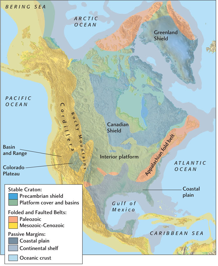
The oldest parts of North America’s crust, built during the most ancient episodes of deformation, tend to be found in the northern interior of the continent. These regions, which include most of Canada and the closely connected landmass of Greenland, are tectonically stable. In other words, they have remained largely undisturbed by recent episodes of continental rifting, drift, and collision, and they have been eroded nearly flat. On the edges of these older tectonic provinces are younger metamorphic belts where most of the present-day mountain chains are found. These mountain chains form elongated topographic features near the margins of the continent. The two main examples are the North American Cordillera, which runs down the western edge of North America and includes the Rocky Mountains, and the Appalachian fold belt, which runs southwest to northeast on the continent’s eastern margin. In our description of tectonic provinces, we will often refer to the geologic time scale shown in Figure 8.15, so you might want to bookmark this figure for reference.
The Stable Interior
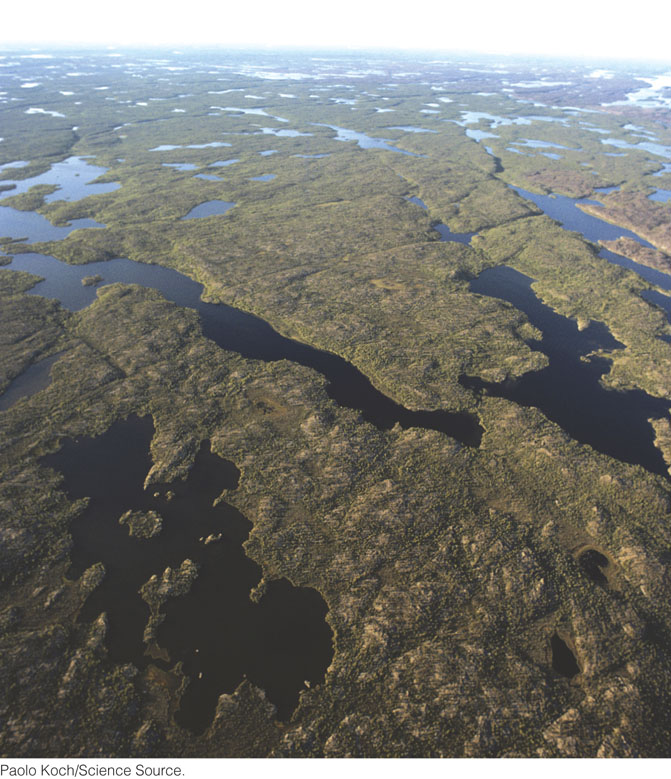
Much of central and eastern Canada is a landscape of very old crystalline basement rock—a huge tectonic province (8 million km2) called the Canadian Shield (Figure 10.2). It consists primarily of Precambrian granitic and metamorphic rocks, such as gneisses, together with highly deformed and metamorphosed sedimentary and volcanic rocks, and it contains major deposits of iron, gold, copper, diamond, and nickel. Large portions of the shield were formed during the Archean eon, so it represents one of the oldest records of Earth’s history. The nineteenth-century Austrian geologist Eduard Suess named these areas continental shields because they emerge from the surrounding sediments like a shield partly buried in the dirt of a battlefield.
255
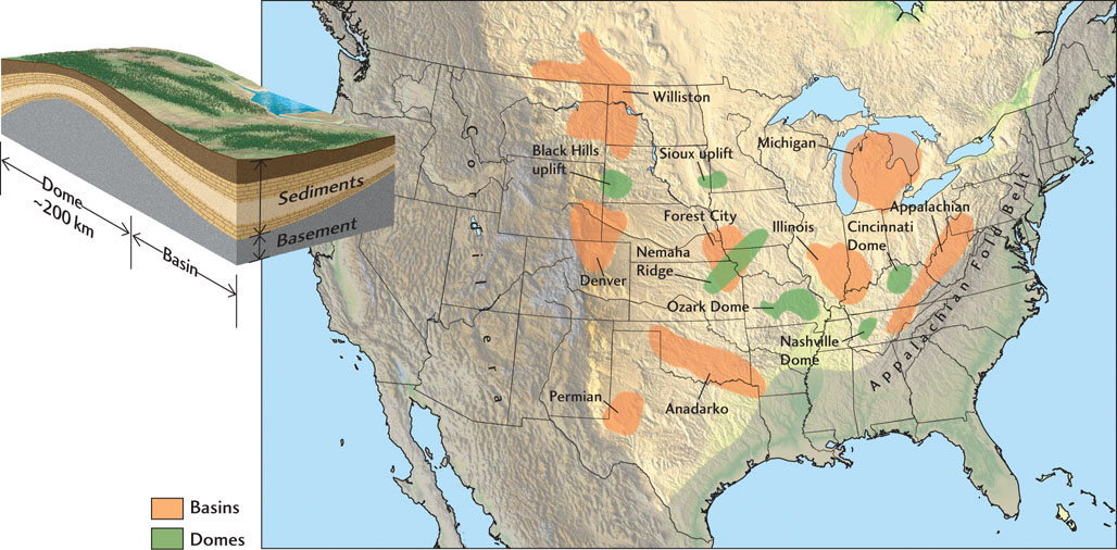
In North America, extensive flat-lying (platform) sediments have been deposited on stable continental crust around the periphery of the Canadian Shield and near its center, beneath Hudson Bay (see Figure 10.1). The vast low-lying, sediment-covered region south and west of the Canadian Shield, which includes the Great Plains of Canada and the United States, is called the interior platform. The Precambrian basement rocks of the interior platform are a continuation of the Canadian Shield, although here they lie under nearly flat layers of Paleozoic sedimentary rocks, typically less than 2 km thick.
The North American platform sediments were laid down on the deformed and eroded Precambrian basement under a variety of conditions. Some rock formations (marine sandstones, limestones, shales, deltaic deposits, evaporites) indicate sedimentation in extensive shallow inland seas. Others (nonmarine sediments, coal deposits) indicate deposition on floodplains or in lakes or wetlands.
Within the interior platform are a number of circular structures: broad sedimentary basins, roughly circular or oval depressions where the sediments are thicker than in the surrounding areas, and domes, areas where the platform sediments have been uplifted and eroded to expose the basement rock (Figure 10.3). Most of the basins are thermal subsidence basins; that is, they are regions that subsided when heated portions of the lithosphere cooled and contracted (see Chapter 5). An example is the Michigan Basin, a circular area of about 200,000 km2 that covers most of the Lower Peninsula of Michigan (see Figure 7.15). This basin subsided throughout much of the Paleozoic era and received sediments more than 5 km thick in its central, deepest part. The sandstones and other sedimentary rocks of these basins, laid down under tectonically quiet conditions, have remained unmetamorphosed and only slightly deformed to this day. The interior platform basins contain important deposits of uranium, coal, oil, and natural gas. Rich mineral deposits in the basement rocks lie close to the surface in the domes, and they may also become traps for oil and gas.
256
The Appalachian Fold Belt
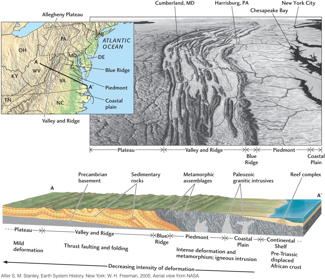
Along the eastern side of North America’s stable interior are the old, eroded Appalachian Mountains. This classic fold and thrust belt, which we first examined in Chapter 7, extends along eastern North America from Newfoundland to Alabama. The rock assemblages and structures of the Appalachians resulted from the continent-continent collisions that formed the supercontinent Pangaea 470 million to 270 million years ago. The western side of the Appalachian belt is bounded by the Allegheny Plateau, a region of slightly uplifted, mildly deformed sediments that is rich in coal and oil. Moving eastward, we encounter regions of increasing deformation (Figure 10.4):
 Valley and Ridge province. Thick Paleozoic sedimentary rocks laid down on an ancient continental shelf were folded and thrust to the northwest by compressive forces from the southeast. The rocks show that the deformation occurred in three mountain-building episodes, one beginning in the middle Ordovician period (about 470 million years ago), one in the middle to late Devonian period (380 million to 360 million years ago), and one in the late Carboniferous and early Permian periods (320 million to 270 million years ago).
-
Blue Ridge province. These eroded mountains are composed largely of highly metamorphosed Precambrian and Cambrian crystalline rocks. The Blue Ridge rocks were not intruded and metamorphosed in place, but rather thrust as sheets over the sedimentary rocks of the Valley and Ridge province near the end of the Paleozoic era, about 300 million years ago.
-
Piedmont. This hilly region contains metamorphosed Precambrian and Paleozoic sedimentary and volcanic rocks intruded by granite, all now eroded to low relief. Volcanism began in late Precambrian time and continued into the Cambrian. The Piedmont rocks were thrust over Blue Ridge rocks along a major thrust fault, overriding them to the northwest. At least two episodes of deformation are evident, coinciding with the last two mountain-building episodes in the Valley and Ridge province.
The Coastal Plain and Continental Shelf
On the Atlantic coastal plain, east of the Appalachian fold belt, relatively undisturbed sediments of Jurassic age and younger are underlain by rocks similar to those of the Piedmont. The coastal plain and its offshore extension, the continental shelf (see Figure 10.1), began to develop in the Triassic period, about 180 million years ago, with the rifting that preceded the breakup of Pangaea and the opening of the modern Atlantic Ocean. Rift valleys formed basins that trapped a thick series of nonmarine sediments. As these deposits were accumulating, they were intruded by basaltic sills and dikes. The Connecticut River valley and the Bay of Fundy are such sediment-filled rift valleys.
257
In the early Cretaceous period, as seafloor spreading widened the Atlantic Ocean, the deeply eroded, sloping surface of the Atlantic coastal plain and continental shelf began to cool, subside, and receive sediments from the continent. Cretaceous and Tertiary sediments as much as 5 km thick filled this slowly developing thermal subsidence basin, and even more material was dumped into the deeper water at the continental margin. This still active basin continues to receive sediments. If the present stage of opening of the Atlantic is reversed some millions of years from now, the sediments in this basin will be folded and faulted in the same kind of process that produced the Appalachians.
The coastal plain and continental shelf of the Gulf of Mexico are continuous extensions of the Atlantic coastal plain and shelf, interrupted only briefly by the Florida Peninsula, a large carbonate platform. The Mississippi, Rio Grande, and other rivers that drain the interior of the North American continent have delivered enough sediments to fill a basin some 10 to 15 km deep running parallel to the coast. The Gulf coastal plain and shelf are rich reservoirs of petroleum and natural gas.
The North American Cordillera
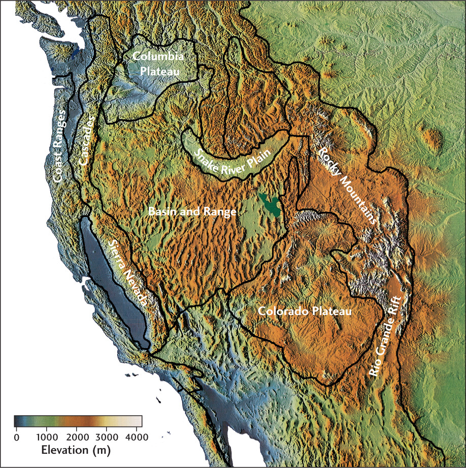
The stable interior platform of North America is bounded on the west by a younger complex of mountain ranges and deformation belts (Figure 10.5). This region is part of the North American Cordillera, a mountain belt extending from Alaska to Guatemala, and it contains some of the highest peaks on the continent. Across its middle section, between San Francisco and Denver, the Cordilleran system is about 1600 km wide and includes several different tectonic provinces: the Coast Ranges along the Pacific Ocean; the lofty Sierra Nevada; the Basin and Range province; the high tableland of the Colorado Plateau; and the rugged Rocky Mountains, which end abruptly at the edge of the Great Plains on the stable interior platform.
258
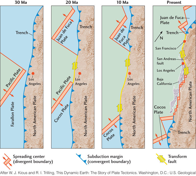
The history of the Cordillera is a complicated one that involves interactions among the Pacific, Farallon, and North American plates over the past 200 million years. Before the breakup of Pangaea, the Farallon Plate occupied most of the eastern Pacific Ocean. As North America moved westward, most of this plate’s oceanic lithosphere was subducted eastward under the continent. The westward margin of the continent swept up island arcs and continental fragments, and the subduction zone eventually swallowed portions of the Pacific-Farallon spreading center, which converted the convergent boundary into the modern San Andreas transform-fault system (Figure 10.6). Today, all that is left of the Farallon Plate are small remnants, including the Juan de Fuca and Cocos plates, which are still subducting beneath North America.
The main phase of Cordilleran mountain building occurred in the last half of the Mesozoic era and in the early Paleogene period (150 million to 50 million years ago). The Cordilleran system is topographically higher than the Appalachians, which is not surprising, as there has been less time for erosion to wear it down. The form and height of the Cordillera that we see today resulted from even more recent events in the Neogene period, over the past 15 million or 20 million years, when the Pacific plate first encountered North America (see Figure 10.6). During these periods, the mountains underwent rejuvenation; that is, they were raised again and brought back to a more youthful stage. At that time, the central and southern Rockies attained much of their present height as a result of broad regional uplift. The Rockies were raised 1500 to 2000 m as Precambrian basement rocks and their veneer of later-deformed sediments were pushed above the level of their surroundings. Stream erosion accelerated, the mountain topography sharpened, and the canyons deepened. As we will see in Chapter 22, rejuvenation is driven not only by plate tectonic processes, but also by interactions between the plate tectonic and climate systems. For example, some of the increase in the relief of the Cordilleran mountain chains may have occurred as a result of the onset of glacial cycles in the Pleistocene.
259
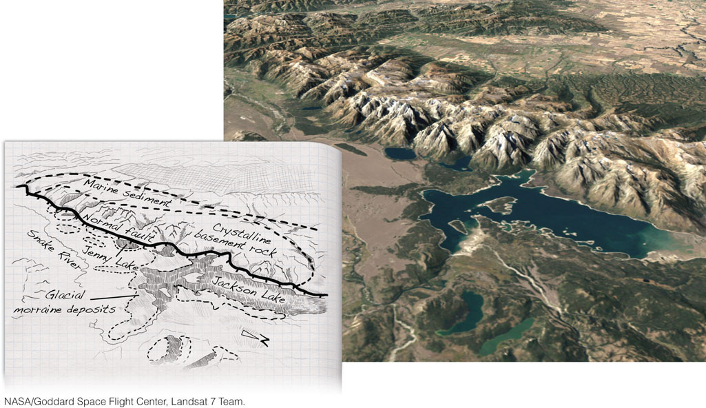
The Basin and Range province developed through the uplift and stretching of the crust in a northwest-southeast direction. This extension began with the heating of the lithosphere by upwelling convection currents in the mantle about 15 million years ago and continues to the present day (see Chapter 7). It has resulted in a wide zone of normal faulting extending from southern Oregon to Mexico and from eastern California to western Texas. The Basin and Range province is volcanically active and contains extensive hydrothermal deposits of gold, silver, copper, and other valuable metals. Thousands of steeply dipping normal faults have sliced the crust into a pattern of upheaved and down-dropped blocks, forming scores of rugged and nearly parallel mountain ranges separated by sediment-filled rift valleys. The Wasatch Range of Utah and the Teton Range of Wyoming (Figure 10.7) are being uplifted on the eastern edge of the Basin and Range province, while the Sierra Nevada of California is being uplifted and tilted on the province’s western edge.
The Colorado Plateau seems to be an island of stability that has experienced no major tension or compression since Precambrian time. The broad uplift of the plateau has allowed the Colorado River to cut through flat-lying sedimentary rock formations, creating the Grand Canyon. Geologists believe that this uplift was caused by the same type of lithospheric heating that is stretching the crust in the Basin and Range province.