How Continents Are Modified
The geology of the North American Cordillera, with its many exotic terrains, looks nothing like that of the ancient Canadian Shield, which lies directly east of the Cordillera. In particular, the accreted terrains of the youthful Cordilleran system do not show the high degree of melting or the high-grade metamorphism that characterize the Precambrian crust of the shield. Why such a difference? The answer lies in the tectonic processes that have repeatedly modified the older parts of the continent throughout its long history.
Orogeny: Modification by Plate Collision
Continental crust is profoundly altered by orogeny—the mountain-building processes of folding, faulting, magmatic addition, and metamorphism. Orogenic processes have repeatedly modified the edges of cratons. Most orogenies (episodes of mountain building) result from plate convergence. When one or both plates are made of oceanic lithosphere, their convergence usually results in subduction rather than orogeny. Orogenies can result when a continent rides forcibly over subducting oceanic crust, as in the Andean orogeny now under way in South America, but the most intense orogenies are caused by the collision of two or more continents. As we observed in Chapter 2, when continents collide, a basic tenet of plate tectonics—the rigidity of plates—must be modified.
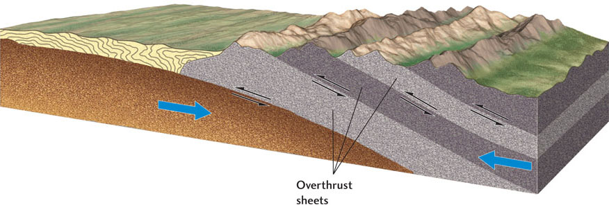
Continental crust is much more buoyant than mantle material, so colliding continents resist being subducted with the plates that carry them. Instead, the continental crust deforms and breaks in a combination of intense folding and faulting that can extend hundreds of kilometers from the collision zone, as described in Chapter 7. Thrust faulting caused by the convergence can stack the upper part of the crust into overthrust sheets tens of kilometers thick, deforming and metamorphosing the rocks they contain (Figure 10.13). Continental shelf sediments can be scraped off the basement rock on which they were deposited and thrust inland. Horizontal compression throughout the crust can double its thickness, causing the rocks in the lower crust to melt. This melting can generate huge amounts of granitic magma, which rises to form extensive batholiths in the upper crust.
The Alpine-Himalayan Orogeny
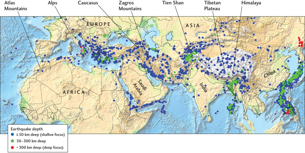
To see orogeny in action today, we look to the great chains of high mountains that stretch from Europe through the Middle East and across Asia, known collectively as the Alpine-Himalayan belt (Figure 10.14). The breakup of Pangaea sent Africa, Arabia, and India northward, causing the Tethys Ocean to close as its lithosphere was subducted beneath Eurasia (see Figure 2.16). These former pieces of Gondwana collided with Eurasia in a complex sequence, beginning in the western part of Eurasia during the Cretaceous period and continuing eastward through the Tertiary, raising the Alps in central Europe, the Caucasus and Zagros mountains in the Middle East, and the Himalaya and other high mountain chains across central Asia.
267
The Himalaya, the world’s highest mountains, are the most spectacular result of this modern episode of continent-continent collision (see the Practicing Geology exercise at the end of the chapter). About 50 million years ago, the Indian subcontinent, riding on the subducting Indian Plate, first encountered the island arcs and volcanic mountain belts that then bounded the Eurasian Plate (Figure 10.15). As the landmasses of India and Eurasia merged, the Tethys Ocean disappeared through subduction. Pieces of the oceanic crust were trapped along the suture zone between the converging continents and can be seen today as ophiolite suites along the Indus and Tsangpo river valleys that separate the high Himalaya from the Tibetan Plateau. The collision slowed India’s advance, but the Indian Plate continued to drive northward. So far, India has penetrated over 2000 km into Eurasia, causing the largest and most intense orogeny of the Cenozoic era.
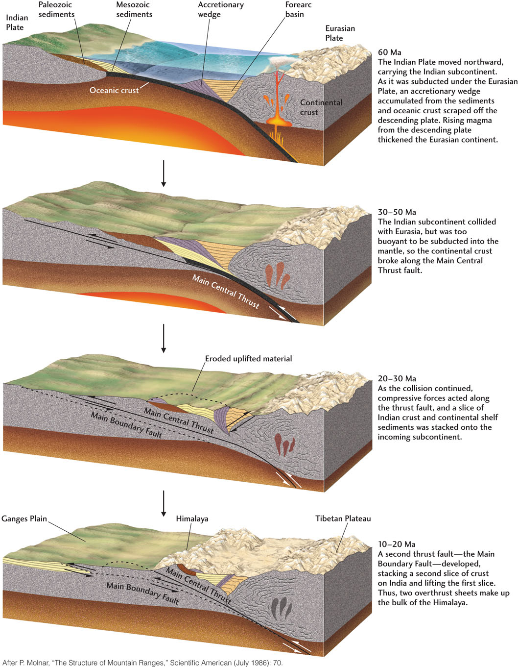
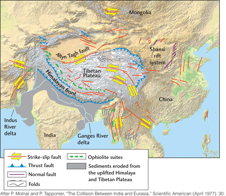
The Himalaya were formed from overthrust slices of the old northern portion of India, stacked one atop the other (see Figure 10.15). This process took up some of the compression. Horizontal compression and the formation of fold and thrust belts also thickened the crust north of India, causing the uplift of the huge Tibetan Plateau, which now has a crustal thickness of 60 to 70 km (almost twice the thickness of most continental crust) and stands nearly 5 km above sea level. These and other compression zones account for perhaps half of India’s penetration into Eurasia. Further compression has pushed China and Mongolia eastward, out of India’s way, like toothpaste squeezed from a tube. Most of this sideways movement has taken place along the Altyn Tagh fault and other major strike-slip faults shown on the map in Figure 10.16. The mountains, plateaus, faults, and great earthquakes of Asia, extending thousands of kilometers from the Indian-Eurasian suture, are all results of the Alpine-Himalayan orogeny, which continues today as India plows into Asia at a rate of 40 to 50 mm/year.
Paleozoic Orogenies During the Assembly of Pangaea
If we go further back in geologic time, we find abundant evidence of older orogenies. We have already mentioned, for example, that at least three distinct orogenies were responsible for the Paleozoic deformation now exposed in the eroded Appalachian fold belt of eastern North America. These three episodes of mountain building were caused by plate convergence that led to the assembly of the supercontinent Pangaea near the end of the Paleozoic era.
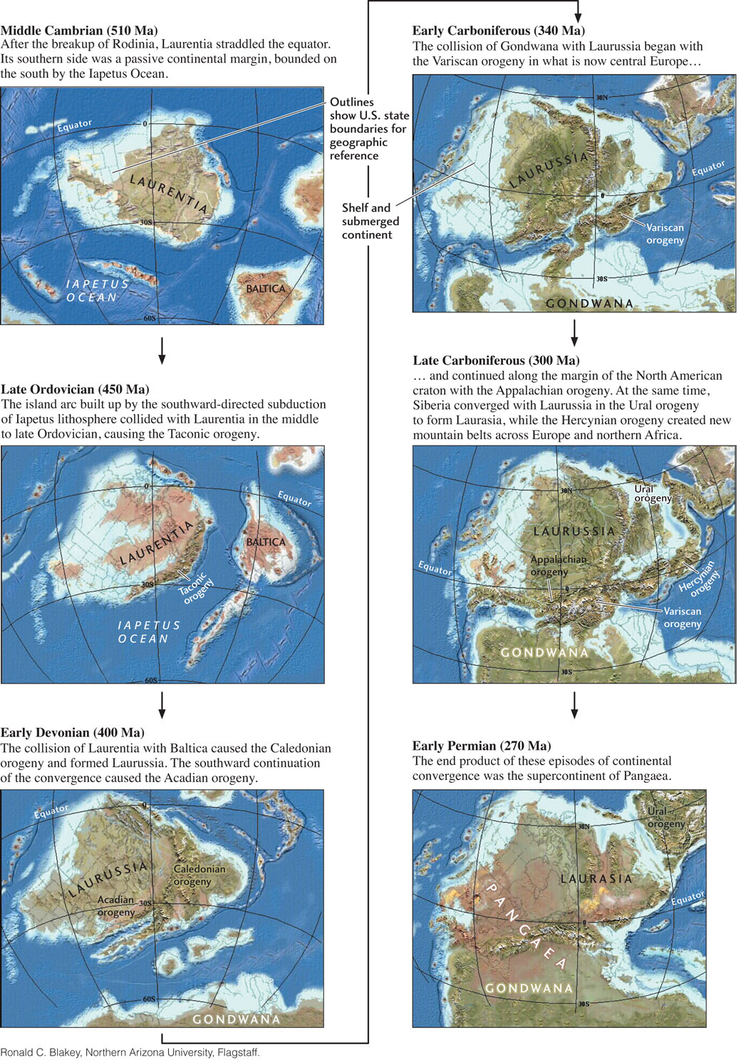
The supercontinent Rodinia began to break up toward the end of the Proterozoic eon, forming several paleocontinents (see Figure 2.16). One was the large continent of Gondwana. Two of the others were Laurentia, which included the North American craton and Greenland, and Baltica, comprising what are now the lands around the Baltic Sea (Scandinavia, Finland, and the European part of Russia). In the Cambrian period, Laurentia was rotated almost 908 from its present orientation and straddled the equator; its southern (today, eastern) side was a passive continental margin. To its immediate south was the proto-Atlantic, or Iapetus, Ocean (in Greek mythology, Iapetus was the father of Atlantis), which was being subducted beneath a distant island arc. Baltica lay off to the southeast, and Gondwana was thousands of kilometers to the south. Figure 10.17 shows the sequence of events as the three continents converged.
268
269
The island arc built up by the southward-directed subduction of Iapetus lithosphere collided with Laurentia in the middle to late Ordovician (470 million to 440 million years ago), causing the first episode of mountain building: the Taconic orogeny. (You can see some of the rocks accreted and deformed during this period if you drive the Taconic State Parkway, which runs east of the Hudson River for about 160 km north of New York City.) The second orogeny began when Baltica and a connected set of island arcs began to collide with Laurentia in the early Devonian (about 400 million years ago). The collision deformed southeastern Greenland, northwestern Norway, and Scotland in what European geologists refer to as the Caledonian orogeny. The deformation continued into present-day North America as the Acadian orogeny, as island arcs that would become the terrains of maritime Canada and New England accreted to Laurentia in the middle to late Devonian (380 million to 360 million years ago).
The grand finale in the assembly of Pangaea was the collision of the behemoth landmass of Gondwana with Laurasia and Baltica, by then joined into a continent named Laurussia. The collision began about 340 million years ago with the Variscan orogeny in what is now central Europe and continued along the margin of the North American craton with the Appalachian orogeny (320 million to 270 million years ago). This latter phase of assembly pushed Gondwanan crust over Laurentia, lifting the Blue Ridge into a mountain chain that may have been as high as the modern Himalaya and causing much of the deformation now seen in the Appalachian fold belt. Also during this phase, Siberia and other Asian terrains converged with Laurussia in the Ural orogeny, forming the continent of Laurasia and pushing up the Ural Mountains. At the same time, extensive deformation created new mountain belts across Europe and northern Africa (the Hercynian orogeny).
The crunching together of all these continental masses profoundly altered the structure of the crust. The rigid cratons were little affected, but the younger accreted terrains caught in between were consolidated, thickened, and metamorphosed. The lower parts of this younger crust were partially melted, producing granitic magmas that rose to form batholiths in the upper crust and volcanoes at the surface. Uplifted mountains and plateaus were eroded, exposing high-grade metamorphic rocks that were once many kilometers deep and depositing thick sedimentary sequences. Sediments laid down following the first orogeny were deformed and metamorphosed by later mountain-building episodes.
Earlier Orogenies
So far, we have investigated two major periods of mountain building: the Paleozoic orogenies associated with the assembly of Pangaea, and the Cenozoic Alpine-Himalayan orogeny. In Chapter 2, we discussed the assembly of the supercontinent Rodinia in the late Proterozoic eon. By now, it should not surprise you to learn that major orogenies accompanied the formation of that earlier supercontinent.
270
271
Some of the best evidence of these orogenies is found at the eastern and southern margins of the Canadian Shield in a broad belt known as the Grenville province, where new crustal material was added to the continent in the middle Proterozoic, about 1.1 billion to 1.0 billion years ago (see Figure 10.8b). Geologists believe that these rocks, which are now highly metamorphosed, originally consisted of volcanic mountain belt and island arc terrains that were accreted and compressed by the collision of Laurentia with the western part of Gondwana. They have drawn analogies between what happened during this Grenville orogeny and what is happening today in the Himalayan orogeny. A Tibet-like plateau was formed by compressive thickening of the crust through folding and thrust faulting, which metamorphosed the upper crust and partially melted large parts of the lower crust. Once the orogeny ceased, erosion of the plateau thinned the crust and exposed crystalline rocks of high metamorphic grade. Geologists have found orogenic belts of similar age on continents worldwide. Although many of the details remain uncertain, they have reconstructed from this geologic record (which includes paleomagnetic data) a general picture of how Rodinia came together between 1.3 billion and 0.9 billion years ago.
The Wilson Cycle
From our brief look at the history of eastern North America, we can infer that the edges of many cratons have experienced multiple episodes of deformation in a general plate tectonic cycle that comprises four main phases (Figure 10.18):
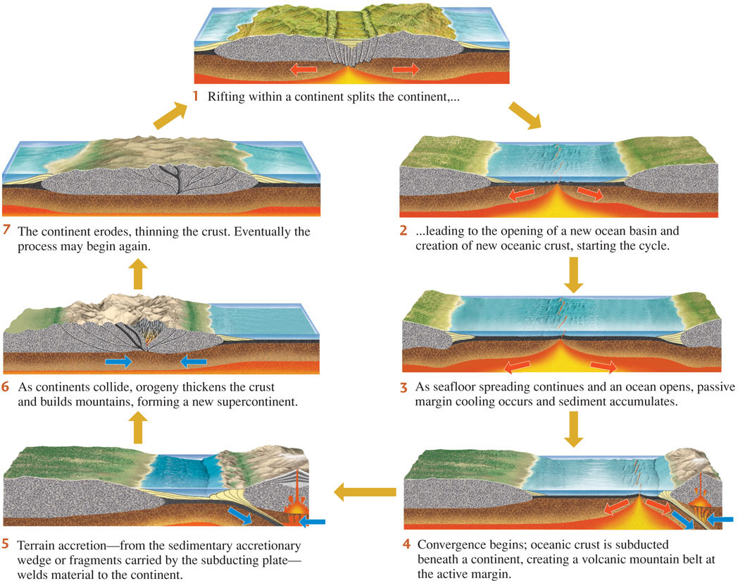
- 1. Rifting during the breakup of a supercontinent
- 2. Passive margin cooling and sediment accumulation during seafloor spreading and ocean opening
- 3. Active margin volcanism and terrain accretion during subduction and ocean closure
- 4. Orogeny during the continent-continent collision that forms the next supercontinent
This idealized sequence of events was named the Wilson cycle after the Canadian pioneer of plate tectonics, J. Tuzo Wilson, who first recognized its importance in the evolution of continents.
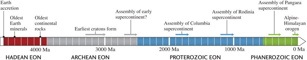
The geologic record suggests that the Wilson cycle has operated throughout the Proterozoic and Phanerozoic eons (Figure 10.19), resulting in the formation of at least two supercontinents prior to Rodinia. One of these supercontinents (named Columbia) formed about 1.9 billion to 1.7 billion years ago. An even earlier one, whose assembly marks the transition from the Archean eon to the Proterozoic eon, formed about 2.7 billion to 2.5 billion years ago. Did the Wilson cycle also operate in the Archean eon? We will return to that question shortly.
Epeirogeny: Modification by Vertical Movements
So far, our consideration of continental evolution has emphasized accretion and orogeny, processes that involve horizontal plate movements and are usually accompanied by deformation in the form of folding and faulting. Throughout the world, however, sedimentary rock sequences record another kind of movement that has modified continents: gradual downward and upward movements of broad regions of crust without significant folding or faulting. These vertical movements are referred to as epeirogeny, a term coined in 1890 by the American geologist Clarence Dutton (from the Greek epeiros, meaning “mainland”).
Epeirogenic downward movements usually result in a sequence of relatively flat-lying sediments, such as those found in the stable interior platform of North America. Upward movements cause erosion and gaps in the sedimentary record seen as unconformities. Erosion can lead to the exposure of crystalline basement rocks, such as those found on the Canadian Shield.
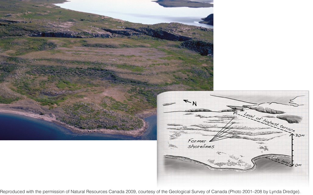
Geologists have identified several mechanisms of epeirogeny. One example is glacial rebound (Figure 10.20a) (see also Earth Issues 14.1). When large glaciers form, their weight depresses the continental crust. When they melt, the crust rebounds upward for tens of millennia. Glacial rebound explains the uplift of Finland and Scandinavia following the most recent glaciation, which ended about 17,000 years ago, as well as the raised beaches of northern Canada (Figure 10.21). Although glacial rebound seems slow by human standards, it is a rapid process, geologically speaking.
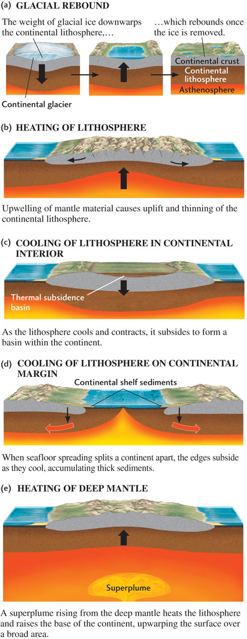
Heating and cooling of the continental lithosphere are important epeirogenic processes on longer time scales. Heating causes rocks to expand, decreasing their density and thus raising the continental surface (Figure 10.20b). A good example is the Colorado Plateau, which has been uplifted to about 2 km above sea level during the last 10 million years or so. Geologists think this heating results from active mantle upwelling, which is also stretching the crust in the Basin and Range province on the western and southern sides of the plateau.
Conversely, the cooling of lithosphere increases its density, making it sink under its own weight and creating a thermal subsidence basin (Figure 10.20c). Cooling of once-hot areas in the continental interior may explain the Michigan Basin and other deep basins in central North America (see Figure 10.3). When a new episode of seafloor spreading splits a continent apart, the uplifted edges are eroded and eventually subside as they cool, forming basins in which sediments are deposited and carbonate platforms accumulate (Figure 10.20d). This process has led to the formation of a thick continental shelf along the east coast of the United States.
One intriguing puzzle is the South African Plateau, where a craton has been uplifted during the Cenozoic to almost 2 km above sea level—more than twice the elevation of most cratons. However, the lithosphere in this part of the continent does not appear to be unusually hot. One possible explanation is that the southern African craton may be uplifted by a hot, buoyant region of the lower mantle (see Chapter 14). This “superplume” could apply upward forces at the base of the lithosphere sufficient to raise the surface by about a kilometer (Figure 10.20e).
273
None of these proposed epeirogenic mechanisms, however, explains a central feature of continental cratons: the existence of raised continental shields and subsided platforms. These regions are too vast, and have persisted too long, to be explained by the plate tectonic processes we have discussed so far.