Volcanism and Human Affairs
Large volcanic eruptions are not just of academic interest to geologists. More than 600 million people live close enough to active volcanoes to be directly affected by eruptions. A repeat of the largest eruptions observed in the geologic record could disrupt or even destroy civilization itself. We must understand volcanic hazards to reduce the risks they pose. But in a world of growing human consumption, we also need to understand and appreciate the benefits volcanism provides to society in the form of mineral resources, fertile soils, and thermal energy.
Volcanic Hazards
Volcanic eruptions have a prominent place in human history and mythology. The myth of the lost continent of Atlantis may have its source in the explosion of Thera, a volcanic island in the Aegean Sea (also known as Santorini). The eruption, which has been dated at 1623 b.c., formed a caldera 7 km by 10 km in diameter, visible today as a lagoon up to 500 m deep with two small active volcanoes in the center. The eruption and the tsunami that followed it destroyed dozens of coastal settlements over a large part of the eastern Mediterranean. Some scientists have attributed the mysterious demise of the Minoan civilization to this ancient catastrophe.
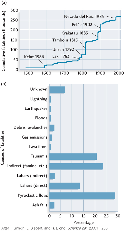
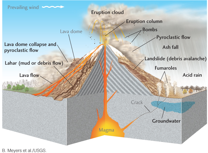
Of the 500 to 600 active volcanoes that rise above sea level (see Figure 12.25), at least one in six is known to have claimed human lives. So far in this century, only about 600 people have died in volcanic eruptions, more than half of them in the 2010 eruptions of Mount Merapi in Indonesia. But history teaches us that this luck will not hold over the longer term. In the past 500 years alone, more than 250,000 people have been killed by volcanic eruptions (Figure 12.29a). Volcanoes can kill people and damage property in many ways, some of which are listed in Figure 12.28b and depicted in Figure 12.30. We have already mentioned some of these hazards, including pyroclastic flows and tsunamis. Several additional volcanic hazards are of special concern.
335
Lahars
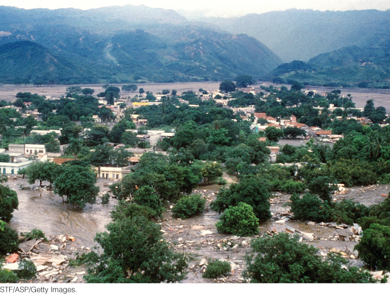
Among the most dangerous volcanic events are the torrential flows of wet volcanic debris called lahars. They can occur when a pyroclastic flow meets a river or a snowbank; when the wall of a water-filled crater breaks; when a lava flow melts glacial ice; or when heavy rainfall transforms new ash deposits into mud. One extensive layer of volcanic debris in the Sierra Nevada of California contains 8000 km3 of material of lahar origin, enough to cover all of Delaware with a deposit more than a kilometer thick. Lahars have been known to carry huge boulders for tens of kilometers. When Nevado del Ruiz in the Colombian Andes erupted in 1985, lahars triggered by the melting of glacial ice near the summit plunged down the slopes and buried the town of Armero 50 km away, killing more than 25,000 people (Figure 12.31). In volcanic terrains beneath icecaps, a common danger is the torrential release of floodwater when magma melts large volumes of glacial ice; this very fluidized type of lahar is called a jökulhlaup (YOU-KYL-LOOP) in Icelandic.
Flank Collapse
A volcanic mountain is constructed from thousands of deposits of lava or pyroclasts or both—not the best way to build a stable structure. The volcano’s sides may become too steep and break or slip off. In recent years, volcanologists have discovered many prehistoric examples of catastrophic structural failures in which a big piece of a volcano broke off, perhaps because of an earthquake, and slid downhill in a massive, destructive landslide. On a worldwide basis, such flank collapses occur at an average rate of about four times per century. The collapse of one side of Mount St. Helens was the most damaging part of its 1980 eruption (see Figure 12.6).
Surveys of the seafloor off the Hawaiian Islands have revealed many giant landslides on the underwater flanks of the Hawaiian Ridge. When they occurred, these massive earth movements probably triggered huge tsunamis. In fact, coral-bearing marine sediments have been found some 300 m above sea level on one of the Hawaiian islands. These sediments were probably deposited by a giant tsunami caused by a prehistoric flank collapse.
The southern flank of Kilauea, on the island of Hawaii, is advancing toward the ocean at a rate of 100 mm/year, which is relatively fast, geologically speaking. This advance became even more worrisome when it suddenly accelerated by a factor of several hundred on November 8, 2000. A network of motion sensors detected an ominous surge in velocity of about 50 mm/day. The surge lasted for 36 hours, after which the normal motion was reestablished. Since then, similar surge events, though variable in size, have been observed every 2–3 years. Someday—maybe thousands of years from now, but perhaps sooner—the southern flank of the volcano is likely to break off and slide into the ocean. This catastrophic event would trigger a tsunami that could prove disastrous for Hawaii, California, and other Pacific coastal areas.
Caldera Collapse
Although infrequent, collapses of large calderas are some of the most destructive natural phenomena on Earth. Monitoring the activity of calderas is very important because of their long-term potential for widespread destruction. Fortunately, no catastrophic collapses have occurred in North America during recorded history, but geologists are concerned about an increase in small earthquakes in the Yellowstone and Long Valley Calderas as well as other indications of activity in their underlying magma chambers. For example, carbon dioxide leaking into the soil from magma in the crust has been killing trees since 1992 on Mammoth Mountain, a volcano on the boundary of Long Valley Caldera. Regions of the Yellowstone caldera have been rising at rates as high as 7 cm/year since 2004, and a swarm of more than a thousand small earthquakes occurred near the center of the caldera in a 2-week period from December 2008 to January 2009. As in the case of the Long Valley Caldera, these observations are consistent with the injection of magma at mid-crustal depths.
336
Eruption Clouds
A less deadly but still costly hazard comes from the eruption of ash clouds that can damage the jet engines of airplanes that fly through them. More than 60 commercial jet passenger planes have been damaged by such clouds. One Boeing 747 temporarily lost all four engines when ash from an erupting volcano in Alaska was sucked into the engines and caused them to flame out. Fortunately, the pilot was able to make an emergency landing. Warnings of eruption clouds near air traffic lanes are now being issued by several countries. The eruptions of the Eyjafjallajökull, Iceland, volcano in April and May of 2010, disrupted air traffic across the North Atlantic, resulting in over a billion dollars of losses to commercial airlines (see Earth Issues 12.1).
337
Reducing the Risks of Volcanic Hazards
There are about 100 high-risk volcanoes in the world today, and some 50 volcanic eruptions occur each year. These volcanic eruptions cannot be prevented, but their catastrophic effects can be greatly reduced by a combination of science and enlightened public policy. Volcanology has progressed to the point that we can identify the world’s dangerous volcanoes and characterize their potential hazards by studying deposits laid down in earlier eruptions. Some potentially dangerous volcanoes in the United States and Canada are identified in Figure 12.32. Assessments of their hazards can be used to guide zoning regulations to restrict land use—the most effective measure to reduce property losses and casualties.
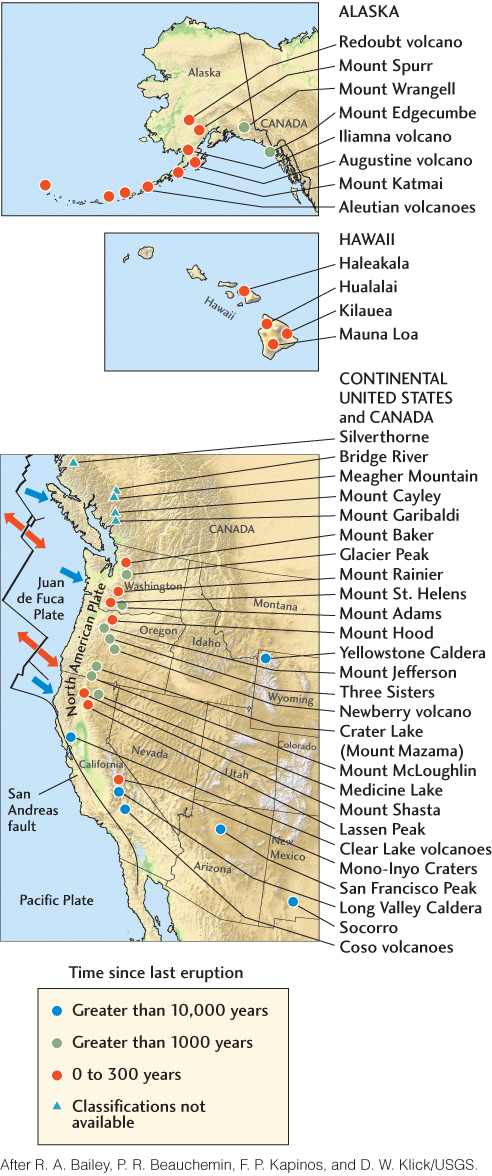
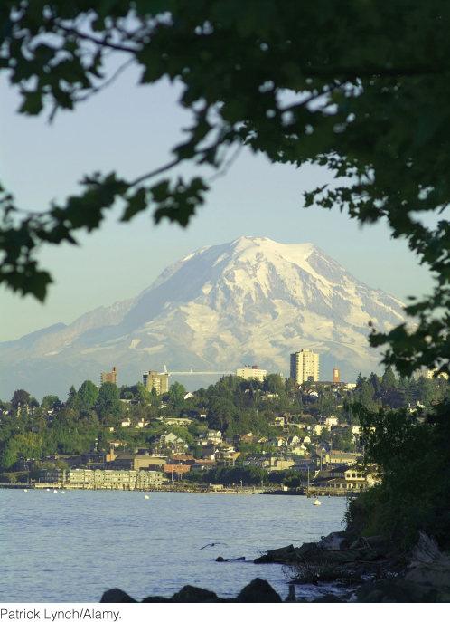
Such studies indicate that Mount Rainier, because of its proximity to the heavily populated cities of Seattle and Tacoma, probably poses the greatest volcanic risk in the United States (Figure 12.33). At least 80,000 people and their homes are at risk in Mount Rainier’s lahar-hazard zones. An eruption could kill thousands of people and cripple the economy of the Pacific Northwest.
338
Earth Issues: 12.2 Mount St. Helens: Dangerous but Predictable
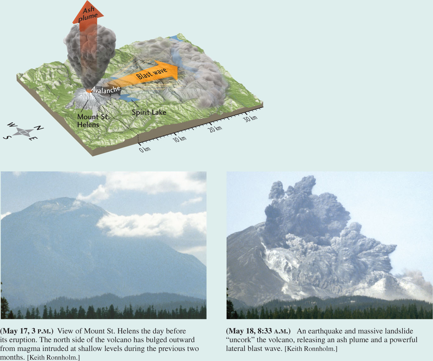
Mount St. Helens, in the Cascade Range of the Pacific Northwest, is the most active and explosive volcano in the contiguous United States (see Figure 12.6). It has a documented 4500-year history of destructive lava flows, pyroclastic flows, lahars, and distant ash falls. Beginning on March 20, 1980, a series of small to moderate earthquakes under the volcano signaled the start of a new eruptive phase after 123 years of dormancy, motivating the U.S. Geological Survey to issue a formal hazard alert. The first outburst of ash and steam erupted from a newly opened crater on the summit one week later.
Throughout April, the seismic tremors increased, indicating that magma was moving beneath the summit, and instruments detected an ominous swelling of the northeastern flank of the mountain. The USGS issued a more serious warning, and people were ordered out of the vicinity. On May 18, the main eruption began abruptly. A large earthquake apparently triggered the collapse of the north side of the mountain, loosening a massive landslide, the largest ever recorded anywhere. As this huge debris avalanche plummeted down the mountain, gas and steam under high pressure were released in a tremendous lateral blast that blew out the northern flank of the mountain.
USGS geologist David A. Johnston was monitoring the volcano from his observation post 8 km to the north. He must have seen the advancing blast wave before he radioed his last message: “Vancouver, Vancouver, this is it!” A northward-directed jet of superheated (500°C) ash, gas, and steam roared out of the breach with hurricane force, devastating a zone 20 km outward from the volcano and 30 km wide. A vertical eruption column sent an ash plume 25 km into the sky, twice as high as a commercial jet flies. The ash plume drifted to the east and northeast with the prevailing winds, bringing darkness at noon to an area 250 km to the east and depositing a layer of ash as deep as 10 cm over much of Washington, northern Idaho, and western Montana. The energy of the blast was equivalent to about 25 million tons of TNT. The volcano’s summit was destroyed, its elevation was reduced by 400 m, and its northern flank disappeared. In effect, the mountain was hollowed out.
Earthquakes and magmatic activity have continued off and on since the 1980 eruption. After more than a decade of relative quiescence, the volcano reawoke in September 2004 with a series of minor steam and ash eruptions that continued into 2005. Growth of the central volcanic dome (see Figure 12.14b) suggests that the current phase of eruptive activity may persist for some time into the future.
Predicting Eruptions
Can volcanic eruptions be predicted? In many cases, the answer is yes. Instrumented monitoring can detect signals such as earthquakes, swelling of the volcano, and gas emissions that warn of impending eruptions. People at risk can be evacuated if the authorities are organized and prepared. Scientists monitoring Mount St. Helens were able to warn people before its eruption in 1980 (see Earth Issues 12.2). Government infrastructure was in place to evaluate the warnings and to enforce evacuation orders, so very few people were killed.
Another successful warning was issued a few days before the cataclysmic eruption of Mount Pinatubo in the Philippines on June 15, 1991. A quarter of a million people were evacuated, including some 16,000 residents of the nearby U.S. Clark Air Force Base (which was heavily damaged by the eruption and has since been permanently abandoned). Tens of thousands of lives were saved from the lahars that destroyed everything in their paths. Casualties were limited to the few who disregarded the evacuation order. And in 1994, 30,000 residents of Rabaul, Papua New Guinea, were successfully evacuated by land and sea hours before the two volcanoes on either side of the town erupted, destroying or damaging most of it. Many owe their lives to the government, which conducted evacuation drills, and to scientists at the local volcano observatory, who issued a warning when their seismographs recorded the ground tremors that signaled magma moving toward the surface.
339
Controlling Eruptions
Can we go further by actually controlling volcanic eruptions? Not likely, because large volcanoes release energy on a scale that dwarfs our capabilities for control. Under special circumstances and on a small scale, however, the damage can be reduced. Perhaps the most successful attempt to manage volcanic activity was made on the Icelandic island of Heimaey in January 1973. By spraying advancing lava with seawater, residents cooled and slowed the flow, preventing the lava from blocking the entrance to their harbor and saving some homes from destruction. The best focus for our efforts, however, will be the establishment of more warning and evacuation systems and more rigorous restriction of settlements in potentially dangerous locations.
Natural Resources from Volcanoes
In this chapter, we have seen something of the beauty of volcanoes and something of their destructiveness. But it should be kept in mind that volcanoes contribute to our well-being in many, though often indirect, ways. Soils derived from volcanic materials are exceptionally fertile because of the mineral nutrients they contain. Volcanic rock, gases, and steam are also sources of important industrial materials and chemicals, such as pumice, boric acid, ammonia, sulfur, carbon dioxide, and some metals. Hydrothermal activity is responsible for the deposition of unusual minerals that concentrate relatively rare elements, particularly metals, into ore deposits of great economic value. Seawater circulating through mid-ocean ridges is a major factor in the formation of such ores and in the maintenance of the chemical balance of the oceans.
340
In some regions where geothermal gradients are steep, Earth’s internal heat can be tapped to heat homes and drive electric generators. Geothermal energy depends on the heating of water as it passes through a region of hot rock (a heat reservoir) that may be hundreds or thousands of meters beneath Earth’s surface. Hot water or steam can be brought to the surface through boreholes drilled for the purpose. Usually, the water is naturally occurring groundwater that seeps downward along fractures in rock. Less typically, the water is artificially introduced by pumping from the surface.
341
By far the most abundant source of geothermal energy is naturally occurring groundwater that has been heated to temperatures of 80°C to 180°C. Water at these relatively low temperatures is used for residential, commercial, and industrial heating. Warm groundwater drawn from a heat reservoir in the Paris sedimentary basin now heats more than 20,000 apartments in France. Reykjavik, the capital of Iceland, which sits atop the Mid-Atlantic Ridge, is almost entirely heated by geothermal energy.
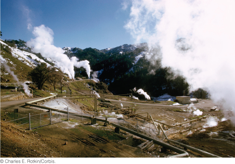
Heat reservoirs with temperatures above 180°C are useful for generating electricity. They are present primarily in regions of recent volcanism as hot, dry rock, natural hot water, or natural steam. Naturally occurring water heated above the boiling point and naturally occurring steam are highly prized resources. The world’s largest facility for producing electricity from natural steam, located at The Geysers, 120 km north of San Francisco, generates more than 600 megawatts of electricity (Figure 12.34). Some 70 geothermal electricity-generating plants operate in California, Utah, Nevada, and Hawaii, producing 2800 megawatts of power—enough to supply about a million people.
342