Intraplate Earthquakes
Although most earthquakes occur at plate boundaries, a small percentage of global seismic activity originates within plate interiors. The foci of these intraplate earthquakes are relatively shallow, and most occur on continents. Among these earthquakes are some of the most famous in American history: a sequence of three large events near New Madrid, Missouri, in 1811–1812; the Charleston, South Carolina, earthquake of 1886; and the Cape Ann earthquake, near Boston, Massachusetts, in 1755. Many intraplate earthquakes occur on old faults that were once parts of ancient plate boundaries. These faults no longer form plate boundaries, but they remain zones of crustal weakness that concentrate and release intraplate stresses.
One of the deadliest intraplate earthquakes (magnitude 7.6) occurred near Bhuj, in the state of Gujarat, in western India, in 2001. It is estimated that some 20,000 lives were lost. The Bhuj earthquake occurred on a previously unknown thrust fault 1000 km south of the boundary between the Indian and Eurasian plates, but the compressive stresses responsible for this rupture resulted from the ongoing collision of these two plates. Intraplate earthquakes show that strong crustal forces can develop and cause faulting within a lithospheric plate far from modern plate boundaries.
Regional Fault Systems
Although the fault mechanisms of most major earthquakes conform to the predictions of plate tectonic theory, a plate boundary can rarely be described as a single fault, particularly when the boundary involves continental crust. Rather, the zone of deformation between two moving plates usually comprises a network of interacting faults—a fault system. The fault system in Southern California provides an interesting example (Figure 13.18).
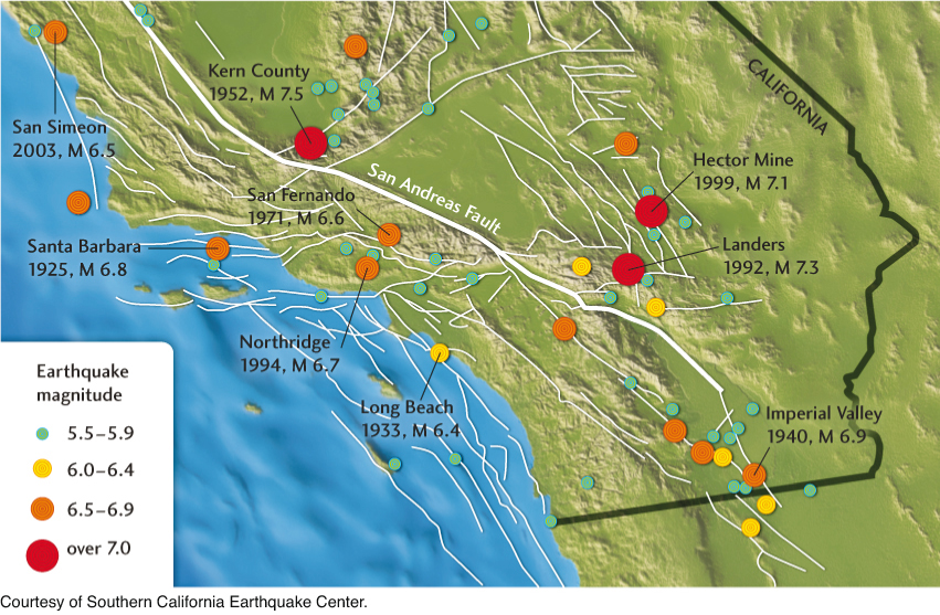
The “master fault” of this system is our old nemesis, the San Andreas—a right-lateral strike-slip fault that runs northwestward through California from the Salton Sea near the Mexican border until it goes offshore in the northern part of the state (see Figure 7.7). There are a number of subsidiary faults on either side of the San Andreas, however, that generate large earthquakes. In fact, most of the damaging earthquakes in Southern California during the past century have occurred on those subsidiary faults.
Why is the San Andreas fault system so complex? Part of the explanation has to do with the geometry of the San Andreas fault itself. A bend in the fault creates compressive forces that cause thrust faulting in the area north of Los Angeles (see Figure 7.22). Thrust faulting in this “Big Bend” was responsible for two recent deadly earthquakes, the San Fernando earthquake of 1971 (magnitude 6.6, 65 people killed) and the Northridge earthquake of 1994 (magnitude 6.7, 58 people killed) (see Figure 13.18). Over the past several million years, this thrust faulting has raised the San Gabriel Mountains to elevations of 1800 to 3000 m.
365
Another complication is the plate extension taking place east of California in the Basin and Range province, which spans the state of Nevada and much of Utah and Arizona (see Chapters 7 and 10). This broad zone of extensional deformation is connected with the San Andreas fault system through a series of faults that run along the eastern side of the Sierra Nevada and through the Mojave Desert. Faults of this system were responsible for the 1992 Landers earthquake (magnitude 7.3) and the 1999 Hector Mine earthquake (magnitude 7.1), as well as the 1872 Owens Valley earthquake (magnitude 7.6).