Hydrology and Climate
For most practical purposes, geologists focus on local hydrology—the amount of water in the reservoirs of a region and how it flows from one reservoir to another—rather than global hydrology. The strongest influence on local hydrology is the local climate, especially temperature and precipitation levels. In warm areas where rain falls frequently throughout the year, water supplies—both at the surface and underground—are abundant. In warm arid or semiarid regions, it rarely rains, and water is a precious resource. People who live in icy climates rely on meltwaters from snow and ice. In some parts of the world, seasons of heavy rain, called monsoons, alternate with long dry seasons during which water supplies shrink, the ground dries out, and vegetation shrivels.
Humidity, Rainfall, and Landscape
Many geographic variations in climate are related to the average temperature of the air and the average amount of water vapor it contains, both of which affect levels of precipitation. The relative humidity is the amount of water vapor in the air, expressed as a percentage of the total amount of water the air could hold at the same temperature if it were saturated. When the relative humidity is 50 percent and the temperature is 15°C, for example, the amount of moisture in the air is one-half the maximum amount the air could hold at 15°C.
Warm air can hold much more water vapor than cold air. When unsaturated warm air cools enough, it becomes supersaturated, and some of its water vapor condenses into water droplets. Those condensed water droplets form clouds. We can see clouds because they are made up of visible water droplets rather than invisible water vapor. When enough moisture has condensed and the droplets have grown too heavy to stay suspended by air currents, they fall as rain.
Most of the world’s rain falls in warm, humid regions near the equator, where both the air and the surface waters of the ocean are warmed by the Sun. Under these conditions, a great deal of ocean water evaporates, resulting in high relative humidity. When air is warmed, it expands, becomes less dense, and rises. When the humid air over tropical oceans rises to high altitudes and blows over nearby continents, it cools, condenses, and becomes supersaturated. The result is heavy rainfall over the land, even at great distances from the coast.
At about 30°N and 30°S latitude, the air that has dropped its precipitation in the tropics begins to sink back toward Earth’s surface. This cold, dry air warms and absorbs moisture as it sinks, producing clear skies and arid climates. Many of the world’s deserts are located at these latitudes.
473
Polar climates also tend to be very dry. The polar oceans and the air above them are cold, so the air can hold little moisture, and little ocean water evaporates. Between the tropical and polar extremes are the temperate climates, where rainfall and temperatures are moderate.
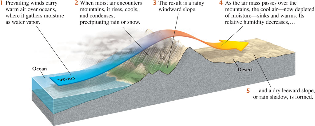
The climate patterns we have just described are driven by patterns of air circulation in the atmosphere, as we’ll see in Chapter 19. Plate tectonic processes also influence climate processes. The uplifting of mountain ranges, for example, forms rain shadows, areas of low precipitation on their leeward (downwind) slopes. Humid winds rising over high mountains cool and precipitate on the windward slopes, losing much of their moisture by the time they reach the leeward slopes (Figure 17.3). The air warms again as it drops to lower elevations on the other side of the mountain range. Because the warmer air can hold more moisture, relative humidity declines, decreasing the likelihood of precipitation even more. The Cascade Range of Oregon, uplifted by the subduction of the Pacific Plate under the North American Plate, creates a rain shadow. The prevailing winds that blow inland from the Pacific Ocean release heavy rainfall on the mountains’ western slopes, supporting a lush forest ecosystem. The eastern slopes, on the other side of the range, are dry and barren.
Just as landscape features can alter precipitation patterns, the resulting variations in precipitation patterns control rates of weathering and erosion, which shape the landscape. In Chapter 22, we will explore further how the climate system and the plate tectonic system act together to control hydrologic patterns involved in landscape development.
Droughts
Droughts—periods of months or years when precipitation is much lower than normal—can occur in all climates, but arid regions are especially vulnerable to their effects. Lacking replenishment from precipitation, streams may shrink and dry up, ponds and lakes may evaporate, and the soil may dry and crack while vegetation dies. As human populations grow, demands on water supplies increase, so a drought can deplete already inadequate supplies.
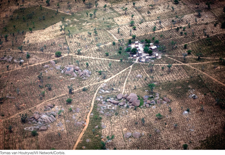
The severest drought of the past few decades has affected a region of Africa known as the Sahel, along the southern border of the Sahara (Figure 17.4). This long drought has expanded the desert, as we’ll see in Chapter 19, and has effectively destroyed farming and grazing. Hundreds of thousands of lives have been lost to famine in the area.
Another prolonged but less severe drought affected most of California from 1987 until February 1993, when torrential rains arrived. During the drought, groundwater and surface reservoirs dropped to their lowest levels in 15 years. Some restrictions on water use were instituted, but a move to reduce the extensive use of water supplies for irrigation encountered strong political resistance from farmers and the agricultural industry. As threats of water shortages loom, the use of water enters the arena of public policy debate (see Earth Policy 17.1).
An example of a shorter term, but high impact event is the 2013 drought in New Zealand. That country experienced a severe, widespread drought from late 2012 until April 2013. The extent of this drought made it unusual—it simultaneously occurred across the entire North Island and parts of the South Island. Many of the pastures are not irrigated and depend on rainfall. The lack of rain caused crop failures and affected pastures in a country where agriculture is a major industry.
474
Earth Policy 17.1: Water Is a Precious Resource: Who Should Get It?
Until recently, most people in the United States have taken their water supply for granted. In the near future, however, because of climate change and population growth, particularly in arid regions, many areas of the country will experience water shortages more and more frequently. These shortages will create conflict among several sectors of society—residential, industrial, agricultural, and recreational—over who has the greatest right to the water supply.

In recent years, widely publicized droughts and restrictions on water use in California, Florida, Colorado, and many other places have made the public aware that the nation faces major water shortages. Public concern waxes and wanes, however, as periods of drought and abundant rainfall come and go and governments fail to pursue long-term solutions with the urgency they deserve. Here are some facts to ponder:
 A human can survive with about 2 liters of water per day. In the United States, per capita water use by individuals is about 250 liters per day. If uses of water for industrial, agricultural, and energy production are considered, then per capita use rises to about 6000 liters per day.
-
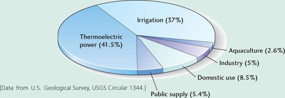
Industry uses about 38 percent and agriculture about 43 percent of the water withdrawn from U.S. reservoirs.
-
Per capita domestic water use in the United States is two to four times greater than in western Europe, where consumers pay as much as 350 percent more for their water.
-
Although the western United States receives one-fourth of the country’s rainfall, per capita water use in the western states (mostly for irrigation) is 10 times greater than that in the eastern states, and water prices are much lower there. In California, for example, which imports most of its water, 85 percent of water use is for irrigation, 10 percent for municipalities and personal consumption, and 5 percent for industry. A 15 percent reduction in irrigation use would almost double the amounts of water available for use by cities and industries.
-
The fresh water used in the United States eventually returns to the hydrologic cycle, but it may return to a reservoir that is not well located for human use, and its quality may be degraded. Recycled irrigation water is often saltier than natural fresh water and is loaded with pesticides. Polluted urban waste water ends up in the oceans.
-
The traditional ways of increasing water supplies, such as building dams and artificial reservoirs and drilling wells, have become extremely costly because most of the best (and therefore cheapest) sites have already been used. Furthermore, the building of more dams to hold larger reservoirs carries environmental costs, such as the flooding of inhabited areas, detrimental changes in river flows above and below the dams, and the disturbance of fish and other wildlife habitats. Factoring in these costs has led to delays in dam projects and rejection of proposals for new dams.
Our climate history can give us perspective on the severity of droughts. The southwestern United States, for example, has been experiencing a recent drought. During the 400-year period from 1500 to 1900, however, the Southwest was drier, on average, than it has been during the last century. Moreover, the geologic record shows droughts that were more severe and of longer duration than the present drought has been (at least so far). Are the recent droughts just short-term fluctuations in climate, or do they signal a return to an extended dry period? How will global climate change affect rainfall in the Southwest? By exploring the past, geologists and climate scientists may find information that will help them predict the future.
The Hydrology of Runoff
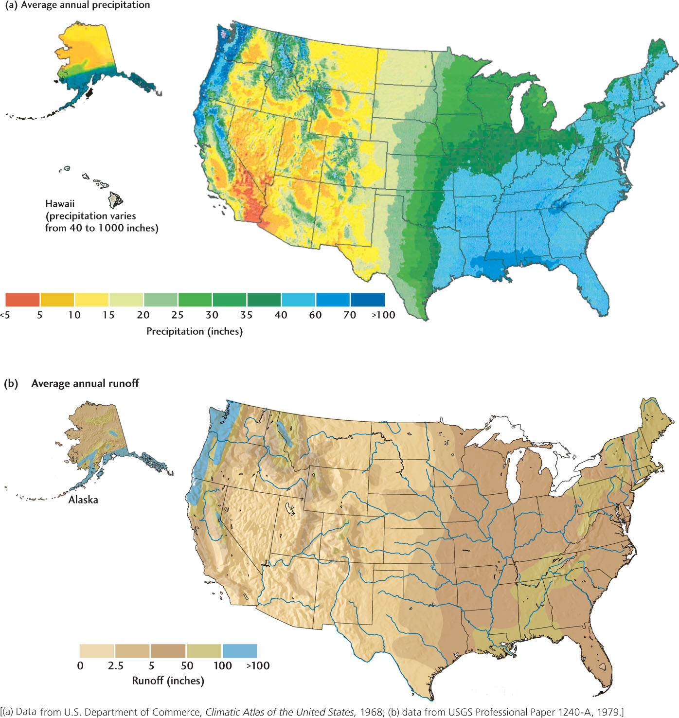
How much of the precipitation that falls on a land area ends up as runoff? A dramatic short-term example of how precipitation levels affect local stream and river runoff can be seen when flash flooding occurs after torrential rains. When levels of precipitation and runoff are measured over a larger area (such as all the states drained by a major river) and over a longer period (such as a year), the relationship between them is less direct, but still strong. The maps in Figure 17.5 illustrate this relationship. When we compare them, we see that in areas of low precipitation—such as Southern California, Arizona, and New Mexico—only a small fraction of precipitation ends up as runoff. In these dry regions, much of the precipitation leaves the land surface by evaporation and infiltration. In more humid areas, such as the southeastern United States, a much higher proportion of the precipitation runs off in streams. A large river may carry large amounts of water from an area with high rainfall to an area with low rainfall. The Colorado River, for example, begins in an area of moderate rainfall in Colorado and then carries its water through arid western Arizona and Southern California.
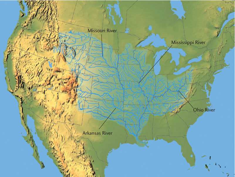
Rivers and streams carry most of the world’s runoff. The millions of small and medium-sized streams carry about half the world’s runoff. About 70 major rivers carry the other half, and the Amazon River of South America carries almost half of that. The Amazon carries about 10 times more water than the Mississippi, the largest river of North America (Table 17.1). The major rivers transport great volumes of water because they collect it from large networks of streams and rivers that cover very large areas. The Mississippi, for example, collects its water from a network of streams that covers about two-thirds of the United States (Figure 17.6).
| River | Water Flow (m3/s) |
|---|---|
| Amazon, South America | 175,000 |
| La Plata, South America | 79,300 |
| Congo, Africa | 39,600 |
| Yangtze, Asia | 21,800 |
| Brahmaputra, Asia | 19,800 |
| Ganges, Asia | 18,700 |
| Mississippi, North America | 17,500 |
476
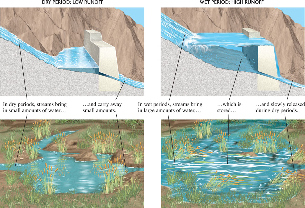
Runoff collects and is stored in natural lakes as well as in artificial reservoirs created by the damming of streams. Wetlands, such as swamps and marshes, also act as reservoirs for runoff (Figure 17.7). If these reservoirs are large enough, they can absorb short-term inflows from major rainfall events, holding some of the water that would otherwise spill over riverbanks. During dry seasons or droughts, these reservoirs release water to streams or to water systems built for human use. Thus, they help to control flooding by smoothing out seasonal or yearly variations in runoff and releasing steady flows of water downstream.
477
In addition to these roles, wetlands are important to biological diversity because they are breeding grounds for a great many types of plants and animals. For all these reasons, many governments have laws that regulate the artificial draining of wetlands for real estate development. Nevertheless, wetlands are disappearing rapidly as land development continues. In the United States, more than half the wetlands that existed before European settlement are now gone. California and Ohio have kept only 10 percent of their original wetlands.