The Hydrology of Groundwater
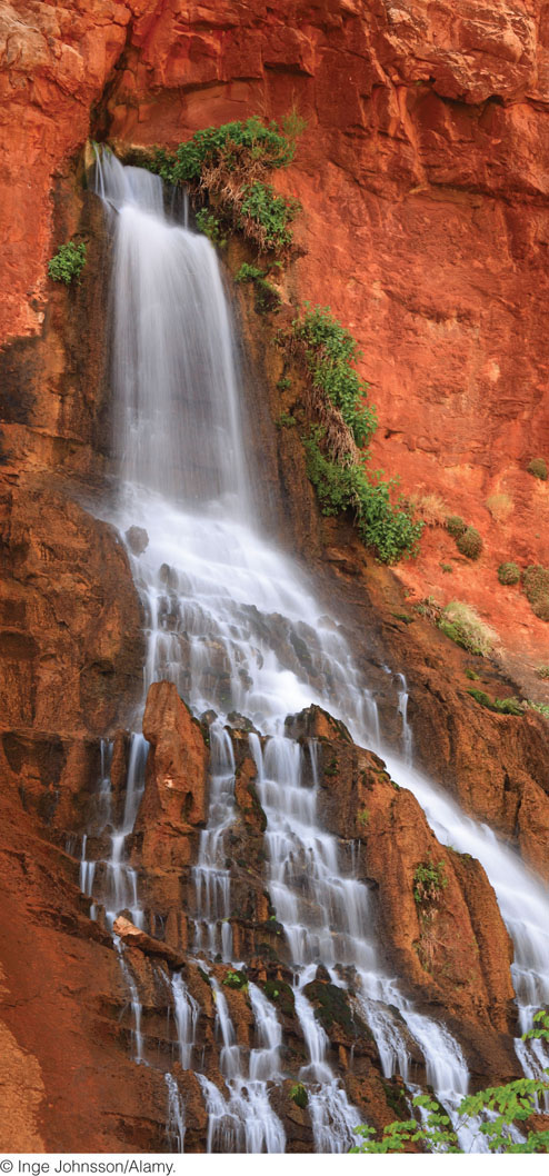
Groundwater forms as raindrops and melting snow infiltrate soil and other unconsolidated surface materials and even sink into the cracks and crevices of bedrock. This groundwater, formed from recent atmospheric precipitation, is known as meteoric water (from the Greek meteoron, “phenomenon in the sky,” which also gives us the word meteorology). The enormous reservoir of groundwater stored beneath Earth’s surface equals about 29 percent of all the fresh water stored in lakes and rivers, glaciers and polar ice, and the atmosphere. For thousands of years, people have drawn on this resource, either by digging shallow wells or by storing water that flows out onto the surface at natural springs. These springs are direct evidence of water moving below the surface (Figure 17.8).
478
Porosity and Permeability
When water moves into and through the ground, what determines where and how fast it flows? With the exception of caves, there are no large open spaces underground for pools or rivers of water. The only spaces available for water are pores and cracks in soil and bedrock. Some pores, however small and few, are found in every kind of rock and soil, but large amounts of pore space are most often found in sandstones and limestones.
Recall from Chapter 5 that the amount of pore space in rock, soil, or sediment determines its porosity: the percentage of its total volume that is taken up by pores. This pore space consists mainly of space between grains and in cracks (Figure 17.9). It can vary from a small percentage of the total volume of the material to as much as 50 percent where rock has been dissolved by chemical weathering. Sedimentary rocks typically have porosities of 5 to 15 percent. Most metamorphic and igneous rocks have little pore space, except where fracturing has occurred.
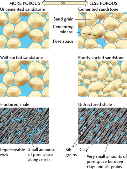
There are three types of pores: spaces between grains (intergranular porosity), spaces in fractures (fracture porosity), and spaces created by dissolution (vuggy porosity). Intergranular porosity, which characterizes soils, sediments, and sedimentary rocks, depends on the size and shape of the grains that make up those materials and on how they are packed together. The more loosely packed the grains, the greater the pore space between them. The smaller the particles, and the more they vary in shape and size, the more tightly they fit together. Minerals that cement grains together reduce intergranular porosity. Intergranular porosity varies from 10 to 40 percent.
Porosity is lower in igneous and metamorphic rocks, in which pore space is created mostly by fractures, including joints and cleavage at natural zones of weakness. Fracture porosity values are commonly as low as 1 to 2 percent, though some fractured rocks contain appreciable pore space—as much as 10 percent of the rock volume—in their many cracks.
Pore space in limestones and other highly soluble rocks such as evaporites may be created when groundwater interacts with the rock and partly dissolves it, leaving irregular voids known as vugs. Vuggy porosity can be very high (over 50 percent); caves are examples of extremely large vugs.
479
Although a rock’s porosity tells us how much water it can hold if all its pores are filled, it gives us no information about how rapidly water can flow through those pores. Water travels through a porous material by winding between grains and through cracks. The smaller the pore spaces, and the more complex the path, the more slowly the water travels. The capacity of a solid to allow fluids to pass through it is its permeability. Generally, permeability increases as porosity increases, but permeability also depends on the sizes of the pores, how well they are connected, and how tortuous a path the fluid must travel to pass through the material. Vuggy pore networks in carbonate rocks may have extremely high permeabilities. Cave systems are so permeable that they allow people as well as water to move through them!
Both porosity and permeability are important considerations for geologists searching for groundwater supplies. In general, a good groundwater reservoir is a body of rock, sediment, or soil that has both high porosity (so that it can hold large amounts of water) and high permeability (so that the water can be pumped from it easily). Well drillers in temperate climates, for example, know that they are most likely to find a good supply of water if they drill into porous sand or sandstone beds not far below the surface. A rock with high porosity but low permeability may contain a great deal of water, but because the water flows so slowly, it is hard to pump it out of the rock. Table 17.2 summarizes the porosities and permeabilities of various rock types.
| Rock or Sediment Type | Porosity | Permeability |
|---|---|---|
| Gravel | Very high | Very high |
| Coarse- to medium-grained sand | High | High |
| Fine-grained sand and silt | Moderate | Moderate to low |
| Sandstone, moderately cemented | Moderate to low | Low |
| Fractured shale or metamorphic rock | Low | Very low |
| Unfractured shale | Very low | Very low |
480
The Groundwater Table
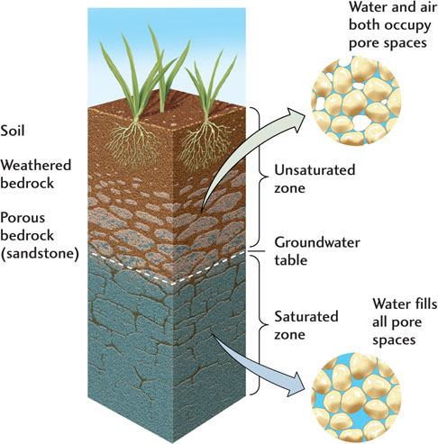
As well drillers bore deeper into soil or rock, the samples they bring up become wetter. At shallow depths, the material is unsaturated: the pores contain some air and are not completely filled with water. This level is called the unsaturated zone (often termed the vadose zone). Below it is the saturated zone (often termed the phreatic zone), in which the pores are completely filled with water. The unsaturated and saturated zones may be in unconsolidated material or in bedrock. The boundary between the two zones is the groundwater table, usually shortened to water table (Figure 17.10). When a hole is dug below the water table, water from the saturated zone flows into the hole and fills it to the level of the water table.
Groundwater moves under the force of gravity, so some of the water in the unsaturated zone may be on its way down to the water table. A fraction of that water, however, remains in the unsaturated zone, held in small pore spaces by surface tension. Surface tension, as you will recall from Chapter 16, is what keeps the sand on a beach moist. Evaporation of this water into pore spaces in the unsaturated zone is slowed both by the effect of surface tension and by the relative humidity of the air in the pore spaces, which can be close to 100 percent.
If we were to drill wells at several sites and measure the elevations of the water levels in those wells, we could construct a map of the water table. A cross section of the landscape might look like the one shown in Figure 17.11a. The water table follows the general shape of the surface topography, but its slopes are gentler. It is exposed at the land surface in river and lake beds and at springs. Under the influence of gravity, groundwater moves downhill from places where the water table elevation is high—under a hill, for example—to places where the water table elevation is low—such as a spring where groundwater flows out onto the surface.
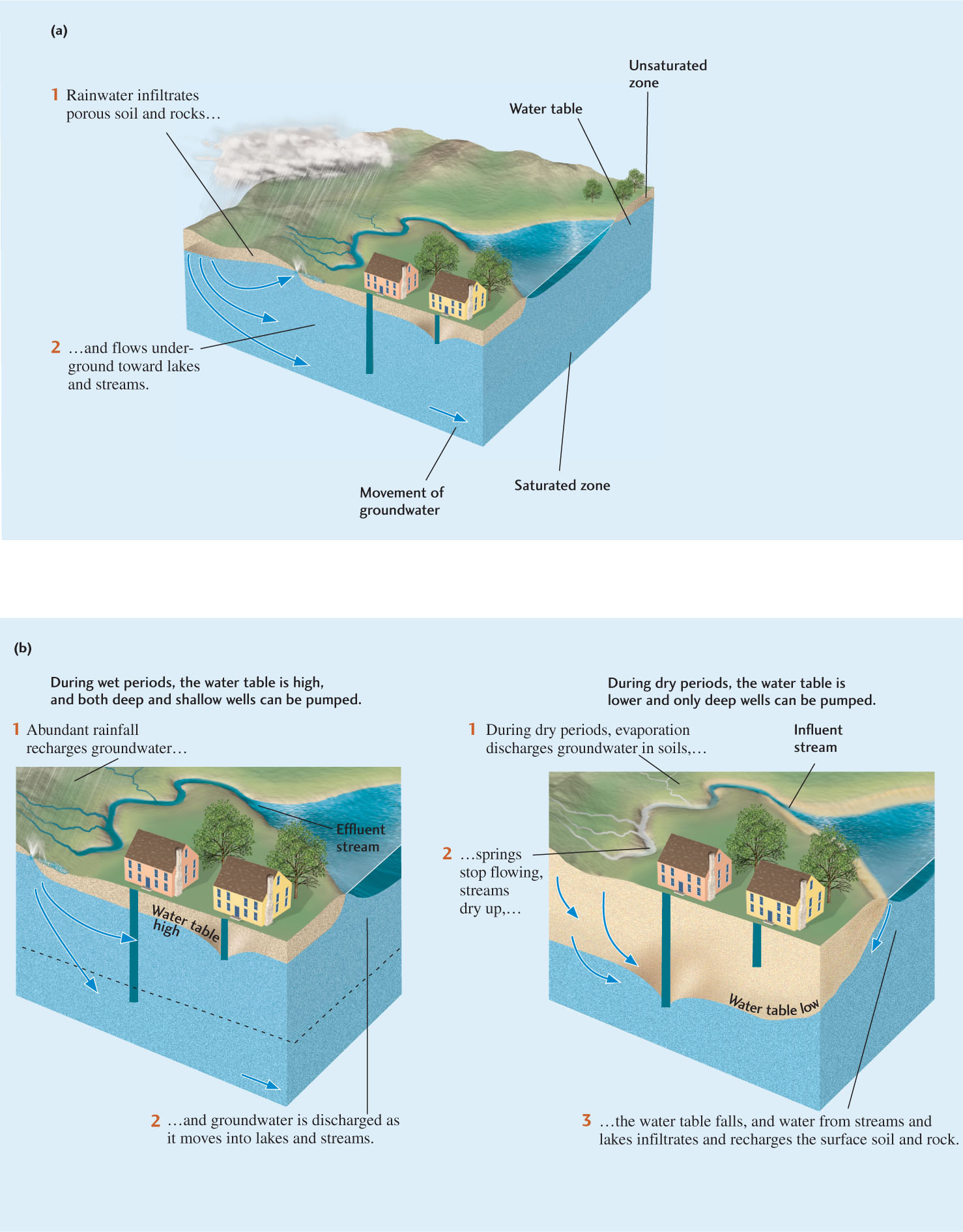
Water enters and leaves the saturated zone through recharge and discharge (Figure 17.11b). Recharge is the infiltration of water into any subsurface formation. Rain and melting snow are the most common sources of recharge. Discharge, the movement of groundwater to the surface, is the opposite of recharge. Groundwater is discharged by evaporation, through springs, and by pumping from artificial wells.
Water may also enter and leave the saturated zone through streams. Recharge may take place through the bottom of a stream whose stream channel lies at an elevation above that of the water table. Streams that recharge groundwater in this way are called influent streams, and they are most characteristic of arid conditions, in which the water table is deep. Conversely, when a stream channel lies at an elevation below that of the water table, water is discharged from the groundwater into the stream. Such an effluent stream is typical of humid conditions. Effluent streams continue to flow long after runoff has stopped because they are fed by groundwater. Thus, the reservoir of groundwater may be increased by influent streams and depleted by effluent streams.
481
482
Aquifers
Rock formations through which groundwater flows in sufficient quantity to supply wells are called aquifers. Groundwater may flow in unconfined or confined aquifers. In unconfined aquifers, the water travels through formations of more or less uniform permeability that extend to the surface. The level of the groundwater reservoir in an unconfined aquifer is the same as the height of the water table (as in Figure 17.11a).
Many permeable formations, however—typically sandstones—are bounded above and below by low--permeability beds, such as shales. These relatively impermeable formations are called aquicludes. Groundwater either cannot flow through them or flows through them very slowly. When aquicludes lie both over and under an aquifer, they form a confined aquifer (Figure 17.12).
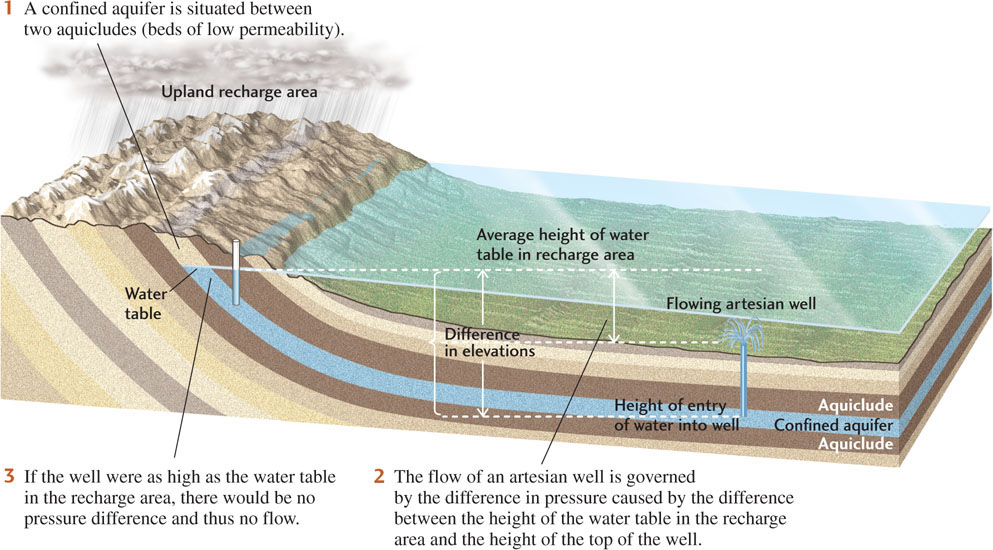
The aquicludes above a confined aquifer prevent rainwater from infiltrating the aquifer directly. Instead, a confined aquifer is recharged by precipitation over a recharge area, often a topographically higher upland characterized by outcrops of permeable rock. Here there is no aquiclude preventing infiltration, so the rainwater travels down to and through the aquifer underground.
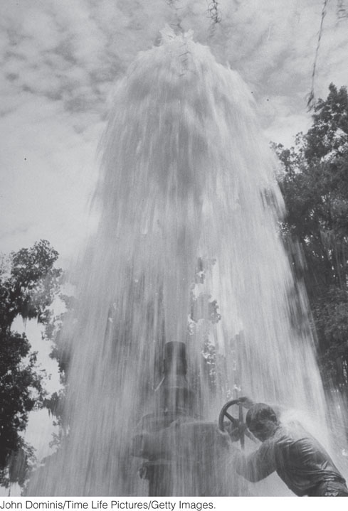
Water moving through a confined aquifer—known as artesian flow—is under pressure. At any point in the aquifer, that pressure is equivalent to the weight of all the water in the aquifer above that point. If we drill a well into a confined aquifer at a point where the elevation of the ground surface is lower than that of the water table in the recharge area, the water will flow out of the well under its own pressure (Figure 17.13). Such wells are called artesian wells, and they are extremely desirable because no energy is required to pump the water to the surface.
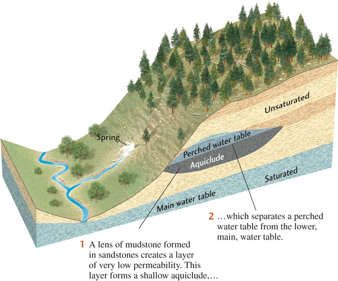
In more complex geologic environments, the water table may be more complicated. For example, if a relatively impermeable mudstone layer forms an aquiclude within an otherwise permeable sandstone formation, the aquiclude may lie below the water table of a shallow aquifer and above the water table of a deeper aquifer (Figure 17.14). The water table in the shallow aquifer is called a perched water table because it is “perched” above the main water table in the deeper aquifer. Many perched water tables are small, only a few meters thick and restricted in area, but some extend for hundreds of square kilometers.
Balancing Recharge and Discharge
When recharge and discharge are balanced, the groundwater reservoir in an aquifer and the elevation of the water table remain constant, even though water is continually flowing through the aquifer. For recharge to balance discharge, rainfall must be frequent enough to compensate for runoff in streams and the outflow from springs and wells.
483
But recharge and discharge are rarely equal because recharge varies with rainfall from season to season. Typically, the water table drops in dry seasons and rises in wet seasons (see Figure 17.11b). A longer period of low recharge, such as a prolonged drought, will be followed by a longer-term imbalance and a greater lowering of the water table.
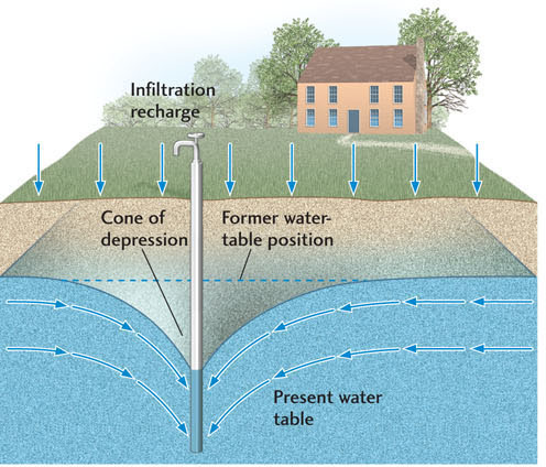
An increase in discharge, usually due to increased pumping from wells, can also produce a long-term imbalance and a lowering of the water table. Shallow wells may end up in the unsaturated zone and go dry. When a well pumps water from an aquifer faster than recharge can replenish it, the water table is lowered in a cone-shaped area around the well, called a cone of depression (Figure 17.15). The water level in the well is lowered to the depressed level of the water table. If the cone of depression extends below the bottom of the well, the well goes dry. If the bottom of the well is above the base of the aquifer, extending the well deeper into the aquifer may allow more water to be withdrawn, even at continued high pumping rates. If the rate of pumping is maintained and the well is deepened so much that the full thickness of the aquifer is tapped, however, the cone of depression can reach the bottom of the aquifer and deplete it. The aquifer will recover only if the pumping rate is reduced enough to give it time to recharge.
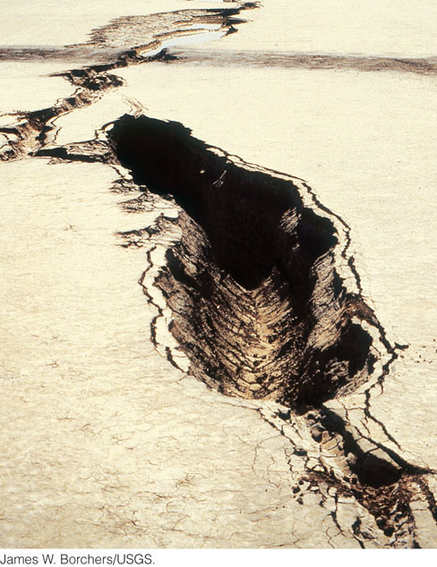
Excessive withdrawals of water may not only deplete the aquifer, but may also cause another undesirable environmental effect. As water pressure in the pore spaces falls, the ground surface overlying the aquifer may subside, creating sinklike depressions (Figure 17.16). As water in some types of sediments is removed, those sediments compact, and the loss of volume lowers the ground surface, a phenomenon known as subsidence. Subsidence caused by excessive pumping has occurred in Mexico City and in Venice, Italy, as well as in many other regions of heavy pumping, such as the San Joaquin Valley in California. In these places, the rate of subsidence has reached almost 1 m every 3 years. Although there have been a few attempts to reverse the subsidence by pumping water back into the ground, they have not been very successful because most compacted materials do not expand to their former state. The best way to halt further subsidence is to restrict pumping.
484
People who live near the ocean’s edge may face a different problem when rates of discharge from an aquifer are high in relation to recharge: a flow of salt water into the aquifer. Near shorelines, or a little offshore, an underground boundary separates salty groundwater under the sea from fresh groundwater under the land. This saltwater margin slopes downward and inland from the shoreline in such a way that salt water underlies the fresh water of the aquifer (Figure 17.17a). Under many oceanic islands, a lens of fresh groundwater (shaped like a simple double-convex lens) floats on a base of seawater. The fresh water floats because it is less dense than the seawater (1.00 g/cm3 versus 1.02 g/cm3, a small but significant difference). Normally, the pressure of the fresh water keeps the saltwater margin slightly offshore. The balance between recharge and discharge in the fresh-water aquifer maintains this freshwater-seawater boundary.
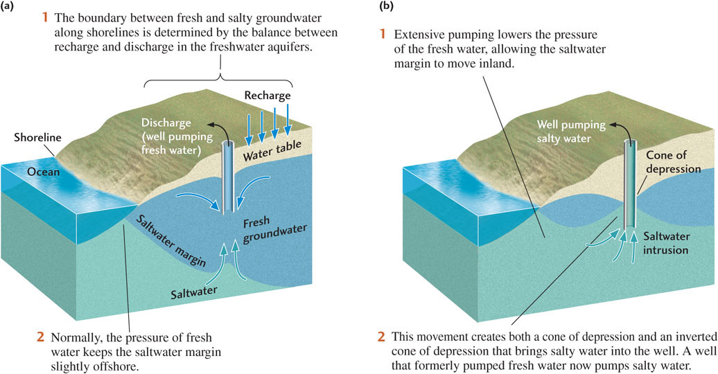
As long as recharge is at least equal to discharge, the aquifer will provide fresh water. If water is withdrawn from a well faster than it can be recharged, however, a cone of depression develops at the top of the aquifer, mirrored by an inverted cone rising from the saltwater margin below. The cone of depression makes it more difficult to pump fresh water, and the inverted cone leads to an intake of salt water at the bottom of the well (Figure 17.17b). People living closest to the coast are the first affected. Some towns on Cape Cod, Massachusetts, on Long Island, New York, and in many other coastal areas have had to post notices that town drinking water contains more salt than is considered healthful by environmental agencies. There is no ready solution to this problem other than to slow the pumping or, in some places, to recharge the aquifer artificially by funneling runoff into the ground.
One of the predicted effects of global warming is a rise in sea level. We can see that as sea level rises, the saltwater margins of coastal aquifers will also rise. Seawater will then invade coastal aquifers and turn fresh groundwater into salt water.
485
The Speed of Groundwater Flows
The speed at which water moves underground strongly affects the balance between discharge and recharge. Most groundwaters flow slowly—a fact of nature that is responsible for our groundwater supplies. If groundwater flowed as rapidly as streams, aquifers would run dry after a period without rain, just as many small streams do. But the slow flow of groundwater also makes rapid recharge impossible if groundwater levels are lowered by excessive pumping.
Although all groundwaters flow through aquifers slowly, some flow more slowly than others. In the middle of the nineteenth century, Henri Darcy, town engineer of Dijon, France, proposed an explanation for the difference in flow rates. While studying the town’s water supply, Darcy measured the elevations of water in various wells and mapped the water table in the district. He calculated the distances that the water traveled from well to well and measured the permeabilities of the aquifers. Here are his findings:
 For a given aquifer and a given distance of travel, the rate at which water flows from one point to another is directly proportional to the vertical drop in elevation of the water table between the two points: as the vertical drop increases, the rate of flow increases.
-
For a given aquifer and a given vertical drop, the rate of flow is inversely proportional to the distance the water travels: as the distance increases, the rate of flow decreases. The ratio of the vertical drop to the flow distance is known as the hydraulic gradient.
Darcy reasoned that the relationship between the rate of flow and the hydraulic gradient should hold whether the water is moving through a well-sorted gravel aquifer or a less permeable silty sandstone aquifer. As you might guess, water moves faster through the large pore spaces of the well-sorted gravel than through the torturous twists and turns of the finer-grained and less permeable silty sandstone. Darcy recognized the importance of permeability and included a measure of permeability in his final explanation of how groundwater flows. So, other things being equal, the greater the permeability, and thus the greater the ease of flow, the faster the flow. The simple equation Darcy developed from these observations, now known as Darcy’s law, can be used to predict the behavior of groundwater and thus has important applications in the management of water resources, as discussed in the Practicing Geology exercise.
Groundwater Resources and Their Management
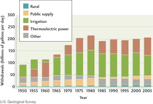
Large parts of North America rely solely on groundwater for all their water needs. The demand for groundwater resources has grown as populations have increased and uses such as irrigation have expanded (Figure 17.18). Many areas of the Great Plains and other parts of the Midwest rest on sandstone formations, most of which are confined aquifers that function like the one shown in Figure 17.12. These aquifers are recharged from outcrops in the western high plains, some very close to the foothills of the Rocky Mountains. From there, the water flows downhill in an easterly direction over hundreds of kilometers. Thousands of wells have been drilled into these aquifers, which constitute a major water resource.
486
Darcy’s law tells us that water flows at a rate proportional to the slope of an aquifer between its recharge area and a given well. In the Great Plains, the slopes are gentle, and water moves through the aquifers slowly, recharging them at low rates. At first, many of the wells drilled in these aquifers were artesian, and the water flowed freely. As more wells were drilled, however, the water levels dropped, and the water had to be pumped to the surface. Today, water is being withdrawn from these aquifers faster than the slow flow from distant recharge areas can fill them, so the reservoirs of groundwater they contain are being depleted (see Earth Policy 17.2).
A variety of innovative approaches are being used to enhance the sustainability of groundwater resources. In some areas, efforts to reduce excessive discharge have been supplemented by attempts to increase the recharge of aquifers artificially. On Long Island, for example, the water authority drilled a large system of recharge wells to pump treated wastewater into the ground. The water authority also constructed large, shallow basins over natural recharge areas to increase infiltration by catching and diverting runoff, including stormwater and industrial waste drainage. The officials in charge of the program knew that urban development can decrease recharge by interfering with infiltration. As urbanization progresses, the impermeable materials used to pave large areas for streets, sidewalks, and parking lots increase runoff and prevent water from infiltrating the ground. Such decreases in natural infiltration may deprive aquifers of much of their recharge. One remedy is to catch and use stormwater runoff in a systematic program of artificial recharge, as the Long Island water authority did. The multiple efforts of the water authority have helped to rebuild the Long Island aquifer, though not to its original levels.
Earth Policy 17.2: The Ogallala Aquifer: An Endangered Groundwater Resource
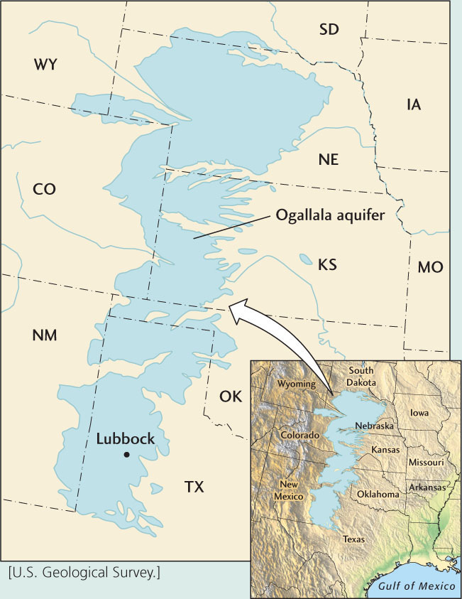
For more than 100 years, groundwater from the Ogallala aquifer, a formation of sand and gravel, has supplied fresh water to the cities, towns, ranches, and farms of much of the southern Great Plains. The population of the region has climbed from a few thousand people late in the nineteenth century to about a million today. Pumping of water from the aquifer, primarily for irrigation, has been so extensive—about 6 billion cubic meters of water per year from 170,000 wells—that recharge from rainfall cannot keep up. Water pressure in the wells has declined steadily, and the water table has dropped by 30 m or more.
Natural recharge of the Ogallala aquifer is very slow because rainfall on the southern Great Plains is sparse, the degree of evaporation is high, and the recharge area is small. The waters in the Ogallala aquifer today may have been supplied as much as 10,000 years ago, during the Wisconsin glaciation, when the climate of the Great Plains was wetter. At current rates of recharge, if all pumping were to stop now, it would take several thousand years for the water table to recover its original elevation and for well pressure to be restored. Some scientists have attempted to recharge the aquifer artificially by injecting water from shallow lakes that form in wet seasons on the high plains. These experiments have managed to increase recharge, but the aquifer is still in danger over the long term.
It is estimated that the remaining supplies of groundwater in the Ogallala aquifer will last only into the early decades of the twenty-first century. If the water it produces cannot be replaced, about 5.1 million acres of irrigated land in western Texas and eastern New Mexico will dry up—and so will 12 percent of the country’s supply of cotton, corn, sorghum, and wheat and a significant fraction of the feedlots for the nation’s cattle.
487
Other aquifers in the northern Great Plains and elsewhere in North America are in a similar condition. In three major areas of the United States—Arizona, the high plains, and California—groundwater supplies have been significantly depleted.
The Kenya Aquifer
A recent study was done from July 2012 to July 2013 of potential groundwater resources in Kenya. The study scanned an area of more than 36,000 square kilometers in north and central Turkana, which is located in northwest Kenya, to assess the available groundwater resources in an area plagued by drought and famine. The approach used satellite and radar imagery, along with geographical surveys, climate maps, and seismic reflection data to create precise groundwater maps of the region. Five aquifers were discovered in the arid Turkana region: the Lotikipi Basin Aquifer (roughly the size of Rhode Island), the smaller Lodwar Basin Aquifer, and three smaller aquifers that need to be confirmed by drilling. The minimum reserve is estimated at 250 billion meters cubed of water (∼66 trillion gallons). The geology of northwest Kenya is a mix of sandstone and volcanics, and porous rocks are ideal for storing groundwater. This potentially enormous groundwater supply can improve the lives of the people in Kenya, where drought, famine, and poverty are prevalent. Not only can the water be used for drinking, but for irrigation of crops and for livestock. Further study is needed to assess if the water quality is safe for drinking, how much water there actually is, how easy it is to access, and how expensive it is to tap. The replenishment rate must be studied so the aquifer isn’t depleted faster than it can be recharged.
Ancient Water
In one of the deepest mines on Earth geologists recently discovered pockets of ancient water trapped in rock that is more than 1.5 billion years old. The discovery was based on a novel dating technique that exploits isotopes of xenon. Xenon and other noble gases accurately record when fluid masses last were in contact with the atmosphere.
The only waters older than this are minute, pinhead-size inclusions within minerals found in rocks that are over 3 billion years old. But water this abundant that actually flows from the rock has never been known before. The water occurs within open fractures, formed billions of years ago when tectonic forces related to continental formation created extensive fracture systems within metamorphic rocks. Some of these fractures became filled with economically valuable minerals but others were just filled with water that has never been in contact with the atmosphere.
This discovery has implications for the habitability of deep crustal environments. The water contains hydrogen and methane that could be used by microorganisms adapted to live in extreme environments (see Chapter 11, “Geobiology: Life Interacts with Earth”). If scientists were able to prove that microbes also live in this environment, then it would show that they too, along with the water, have been evolving in isolation for potentially billions of years. And, as we turn our attention increasingly to wonder about the potential habitability of Mars, it allows for the possibility that similar microbes could also occupy similar subterranean fractures systems that exist on planetary timescales.
488
Orange County, near Los Angeles, California, receives only about 15 inches of rainfall per year, yet this water must supply a population of 2.5 million people. Groundwater pumped from beneath the western part of the county meets about 75 percent of its requirements. The water table is gradually dropping, however, threatening to diminish this supply. To help replenish the supply, the Orange County Water District operates 23 wells that inject treated wastewater, mixed with groundwater from a second aquifer that is located beneath the county’s main aquifer. The recycled water meets drinking water standards with additional treatment, but most of the contaminants are filtered out by the aquifer’s pore network.