The Form of Streams
We use the word stream for any body of water, large or small, that flows over the land surface, and river for the major branches of a large stream system. Most streams run through well-defined troughs called channels, which allow water to flow over long distances. As streams move across Earth’s surface—in some places over bedrock, in others over unconsolidated sediments—they erode these materials and create valleys.
Identifying and mapping stream valleys were essential tasks for Lewis and Clark during their mission 200 years ago. As they traveled upstream and the river branched, they had to choose which branch was the larger of the two. They used two observations to help them make this choice: the width of the stream valley and the depth of the stream channel. Was the valley wide enough, and the channel deep enough, for their boats? Narrow valleys and shallow channels would mean that the branch led into a much shorter, and therefore less desirable, route; wider valleys and deeper channels, on the other hand, promised a longer passage up the main branch of the river.
Stream Valleys
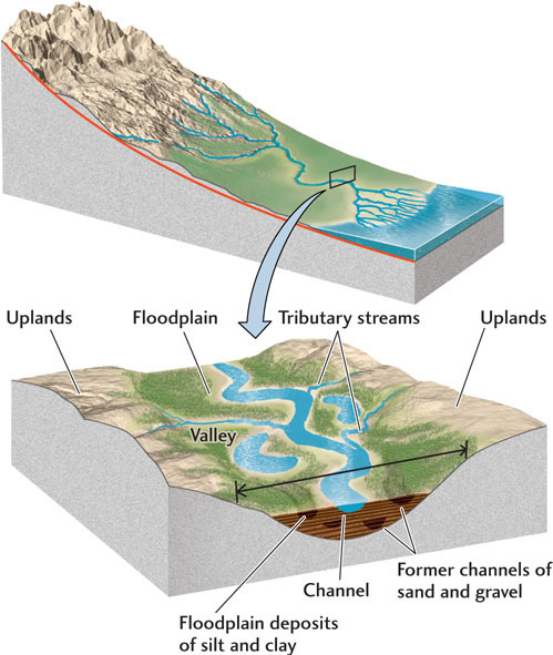
A stream valley encompasses the entire area between the tops of the slopes on both sides of the stream. The cross-sectional profile of many stream valleys is V-shaped, but many other stream valleys have a broad, low profile like that shown in Figure 18.1. At the bottom of the valley is the channel, the trough through which the water runs. The channel carries all the water during normal, nonflood times. At low water levels, the stream may run only along the bottom of the channel. At high water levels, the stream occupies most of the channel. In broad valleys, a floodplain—a flat area about level with the top of the channel—lies on either side of the channel. It is this part of the valley that is flooded when the stream spills over its banks, carrying with it silt and sand from the channel.
In high mountains, stream valleys are narrow and have steep walls, and the channel may occupy most or all of the valley bottom (Figure 18.2). A small floodplain may be visible only at low water levels. In such valleys, the stream is actively cutting into the bedrock, a process that is characteristic of newly uplifted highlands in tectonically active areas. Its erosion of the valley walls is helped by chemical weathering and mass wasting. In lowlands, where tectonic uplift has long since ceased, the stream shapes its valley by eroding sediment particles and transporting them downstream. With a long time to operate, these processes produce gentle slopes and floodplains many kilometers wide.
Channel Patterns
As a stream channel makes its way along the bottom of a valley, it may run straight in some stretches and take a snaking, irregular path in others, sometimes splitting into multiple channels. The channel may run along the center of the floodplain or hug one edge of the valley.
501
Meanders
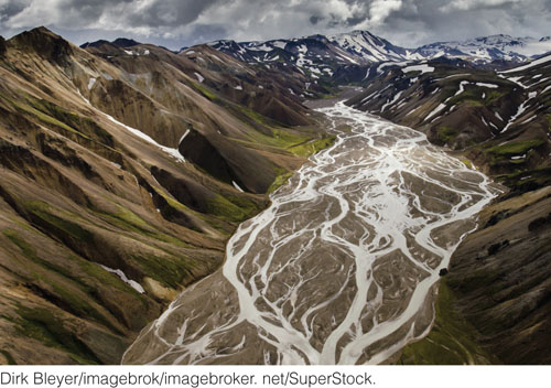
On a great many floodplains, stream channels follow curves and bends called meanders, named for the Maiandros (now Menderes) River in Turkey, known in ancient times for its winding, twisting course. Meanders are the normal pattern for low-velocity streams flowing through gently sloping or nearly flat plains or lowlands, where their channels typically cut through unconsolidated sediments—fine sand, silt, or mud—or easily eroded bedrock. Meanders are less pronounced, but still common, in streams flowing down slightly steeper slopes over harder bedrock. In such terrain, meandering stretches may alternate with long, relatively straight ones.
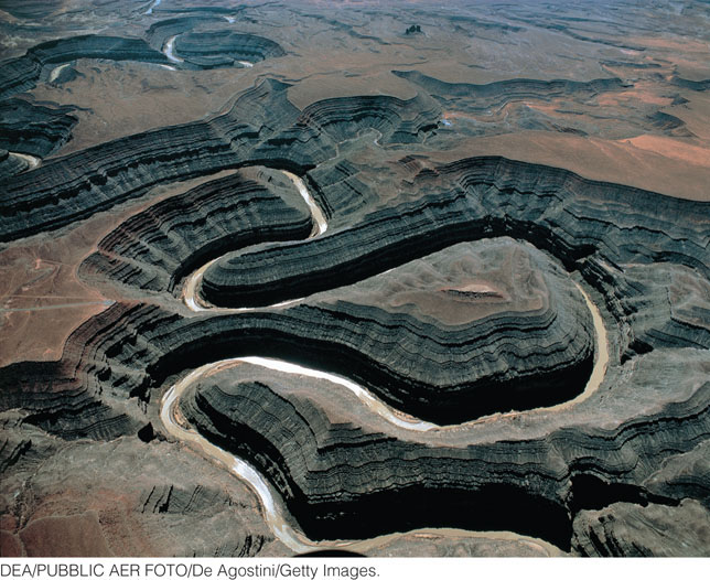
A stream that has cut deeply into the curves and bends of its channel may produce incised meanders (see Figure 18.2). Other streams meander on somewhat wider floodplains bounded by steep, rocky valley walls. We are not sure why these two different patterns appear. We do know that meandering is widespread not only in streams, but also in many other kinds of flows. For example, the Gulf Stream, a powerful current in the western North Atlantic Ocean, meanders. Lava flows on Earth meander, and planetary geologists have found meanders in former water channels on Mars (see Figures 9.20 and 9.21) as well as in lava flows on Mars and Venus.
Meanders on a floodplain migrate over periods of many years as the stream erodes the outside banks of bends, where the current is strongest (Figure 18.3a). As the outside banks are eroded, sediments are deposited to form curved sandbars, called point bars, along the inside banks, where the current is weaker (Figure 18.3b). In this way, meanders slowly shift position from side to side, as well as downstream, in a snaking motion something like that of a long rope being snapped. This migration may be quite rapid: some meanders on the Mississippi River shift as much as 20 m/year. As meanders move, so do the point bars, building up an accumulation of sand and silt over the part of the floodplain across which the channel migrated.
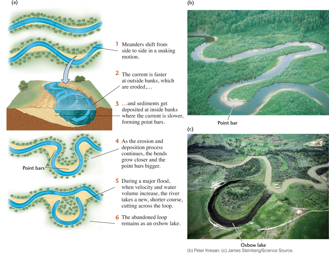
As meanders migrate, sometimes unevenly, the bends may grow closer and closer together, until finally the stream bypasses one of them, often during a major flood. The stream then takes a new, shorter course. In its abandoned path, it leaves behind an oxbow lake: a crescent-shaped, water-filled loop (Figure 18.3c).
Engineers sometimes artificially straighten and confine a meandering river, channelizing it along a straight path with the aid of artificial levees made of concrete. The Army Corps of Engineers has been channelizing the Mississippi River since 1878. In 13 years, it decreased the length of the lower Mississippi by 243 km. Part of the severity of the disastrous Mississippi flood of 1993 was ascribed to channelization. Without channelization, floods are more frequent, but less damaging. With it, damage may be catastrophic when a flood breaches the artificial levees, as it did in 1993. Channelization has also been criticized for destroying wetlands and much of the natural life of the floodplain by cutting off the supply of sediments deposited by small, frequent floods.
502
Such environmental concerns stimulated action to restore one channelized river, the Kissimmee in central Florida, to its original meandering course. Today, this restoration project is well under way. If left to its own natural processes, the Kissimmee might have taken many decades or hundreds of years to restore itself.
Braided Streams
Some streams have many channels instead of a single one. A braided stream is a stream whose channel divides into an interlacing network of channels, which then rejoin in a pattern resembling braids of hair (Figure 18.4). Braided streams are found in many settings, from broad lowland valleys to wide, sediment-filled rift valleys adjacent to mountain ranges. Braids tend to form in streams with large variations in volume of flow combined with a high sediment load and banks that are easily eroded. They are well developed, for example, in the sediment-choked streams formed at the edges of melting glaciers. Currents in braided streams are usually swiftly flowing, in contrast to those in meandering streams.
503
Stream Floodplains
A stream channel migrating over the floor of a valley creates a floodplain. Point bars formed during migration build up the surface of the floodplain, as does sediment deposited by floodwaters. Erosional floodplains, covered with a thin layer of sediment, can form when a stream erodes bedrock or unconsolidated sediment as it migrates.
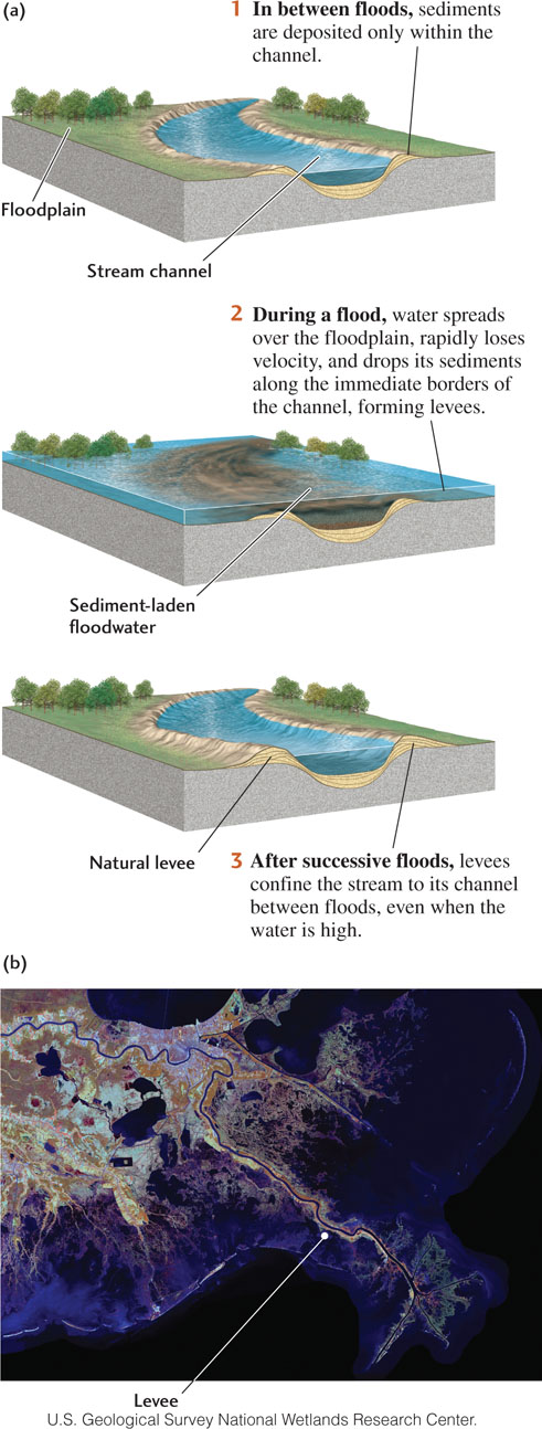
When a stream overflows its banks and floodwaters spread out over the floodplain, the velocity of the water slows, and the current loses its ability to carry sediment. The floodwater velocity drops most quickly along the immediate borders of the channel. As a result, the current deposits large amounts of coarse sediment, typically sand and gravel, along a narrow strip at the edge of the channel. Successive floods build up natural levees, ridges of coarse material that confine the stream within its banks between floods, even when water levels are high (Figure 18.5). Where natural levees have reached a height of several meters and the stream almost fills the channel, the floodplain level is below the stream level. You can walk the streets of an old river town built on a floodplain, such as Vicksburg, Mississippi, and look up at the levee, knowing that the river waters are rushing by above your head.
During floods, fine sediments—silts and muds—are carried well beyond the stream’s banks, often over the entire floodplain, and are deposited there as floodwaters continue to lose velocity. Receding floodwaters leave behind standing ponds and pools of water. The finest clays are deposited there as the standing water slowly disappears by evaporation and infiltration. These fine-grained floodplain deposits, which are rich in mineral and organic nutrients, have been a major resource for agriculture since ancient times. The fertility of the floodplains of the Nile and other rivers of the Middle East, for example, contributed to the evolution of the cultures that flourished there thousands of years ago. Today, the great, broad floodplain of the Ganges in northern India continues to play an important role in India’s life and agriculture. Many ancient and modern cities are sited on floodplains (see Earth Issues 18.1).
Drainage Basins
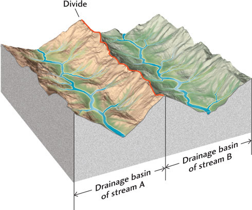
Every topographic rise between two streams, whether it measures a few meters or a thousand, forms a divide: a ridge of high ground along which all rainfall runs off down one side or the other. A drainage basin is an area of land, bounded by divides, that funnels all its water into the network of streams draining that area (Figure 18.6). Drainage basins occur at many scales, from a ravine surrounding a small stream to a great region drained by a major river and its tributaries (Figure 18.7).
504
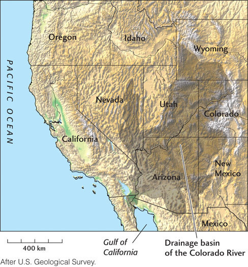
A continent has several major drainage basins separated by major divides. In North America, the continental divide formed by the Rocky Mountains separates all waters flowing into the Pacific Ocean from all those entering the Atlantic. Lewis and Clark followed the Missouri River upstream to its headwaters at the continental divide in western Montana. After crossing over the divide, they found the headwaters of the Columbia River, which they followed to the Pacific Ocean.
505
Drainage Networks
A map showing the courses of all the large and small streams in a drainage basin reveals a pattern of connections called a drainage network. If you followed a stream from its mouth (where it ends) to its headwaters (where it begins), you would see that it steadily divides into smaller and smaller tributaries, forming a drainage network that shows a characteristic branching pattern.
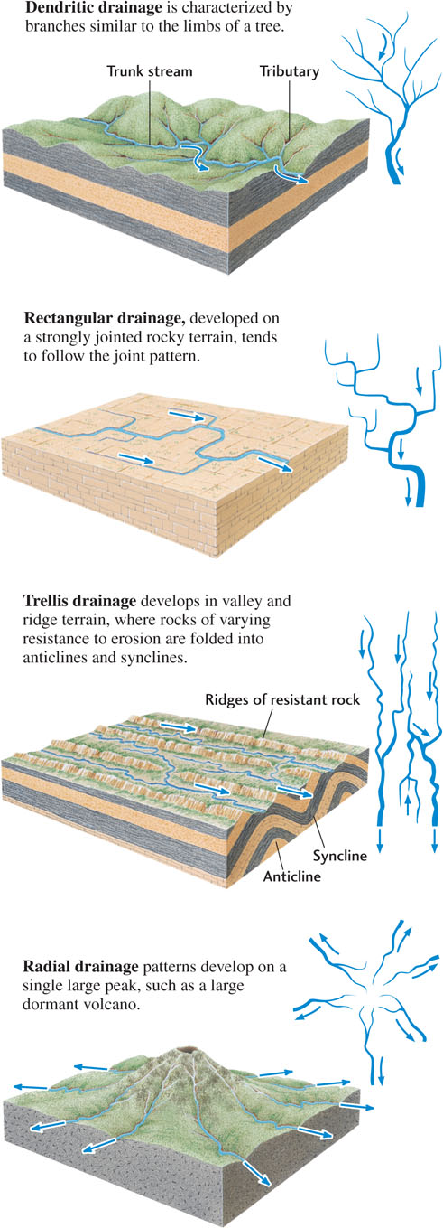
Branching is a general property of many kinds of networks in which material is collected and distributed. Perhaps the most familiar branching networks are those of tree branches and roots. Most rivers follow the same kind of irregular branching pattern, called dendritic drainage (from the Greek dendron, meaning “tree”). This fairly random drainage pattern is typical of terrains where the bedrock is of a uniform type, such as horizontally bedded sedimentary rock or massive igneous or metamorphic rock. Other drainage patterns are described as rectangular, trellis, and radial (Figure 18.8).
Drainage Patterns and Geologic History
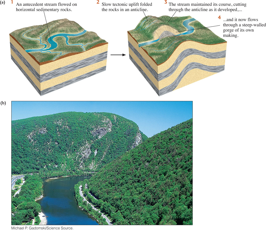
We can observe directly, or determine from historical or geologic records, how most stream drainage patterns developed. Some streams, for example, cut through erosion-resistant bedrock ridges to form steep-walled notches or gorges. What could cause a stream to cut a narrow valley directly through a ridge rather than running along the lowland on either side of it? The geologic history of the region provides the answers.
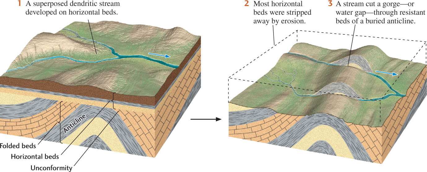
If a ridge is formed by deformation while a preexisting stream is flowing over it, the stream may erode the rising ridge to form a steep-walled gorge, as in Figure 18.9. Such a stream is called an antecedent stream because it existed before the present topography was created. The stream maintains its original course despite changes in the underlying rocks and in the topography.
506
Earth Issues: 18.1 The Development of Cities on Floodplains
Floodplains have attracted human settlement since the beginning of civilization. Floodplains are natural sites for urban settlements because they combine easy transportation along a river with access to fertile agricultural lands. Such sites, however, remain subject to the floods that formed the floodplains. Small floods are common and usually cause little damage, but the larger episodes that happen every few decades or so can be quite destructive.
About 4000 years ago, cities began to dot floodplains in Egypt along the Nile, in the ancient land of Mesopotamia along the Tigris and Euphrates rivers, and in Asia along the Indus River of India and the Yangtze and Huang Ho of China. Later, many of the capital cities of Europe were built on floodplains: Rome on the Tiber, London on the Thames, Paris on the Seine. Floodplain cities in North America include St. Louis on the Mississippi, Cincinnati on the Ohio, and Montreal on the St. Lawrence. Floods periodically destroyed sections of these ancient and modern cities on the lower parts of the floodplains, but each time the inhabitants rebuilt them.
Today, most large cities are protected by artificial levees that strengthen and heighten the river’s natural levees. In addition, extensive systems of dams help control the flooding that would affect these cities. But these structures cannot eliminate the risk entirely. In 1973, for example, the Mississippi River went on a rampage with a flood that continued for 77 consecutive days at St. Louis, Missouri. The river reached a record 4.03 m above flood stage. In 1993, the Mississippi and its tributaries broke loose again, shattering the old record in a disastrous flood that has been officially designated the second worst flood in U.S. history (behind the flooding of New Orleans by the storm surge from Hurricane Katrina in 2005). The flood resulted in 487 deaths and more than $15 billion in property damage. At St. Louis, the Mississippi stayed above flood stage for 144 of the 183 days between April and September. In an unexpected secondary effect, the floodwaters leached agricultural chemicals from farmlands and deposited them in the flooded areas, causing widespread pollution.
Figuring out how to protect society from floods presents some knotty problems. Some geologists believe that the construction of artificial levees to confine the Mississippi contributed to its record floods. A river hemmed in by artificial levees can no longer erode its banks and widen its channel to accommodate additional water during periods of high flow. In addition, the floodplain no longer receives deposits of sediment. In the case of New Orleans, the floodplain has sunk below the level of the Mississippi River, making future flooding more likely.
What are cities and towns in this position to do? Some have urged a halt to all construction and development on the lowest parts of floodplains. Some have called for the elimination of federally subsidized disaster funds for rebuilding in such areas. Harrisburg, Pennsylvania, hit hard by a flood in 1972, turned some of its devastated riverfront area into a park. In a dramatic step after the 1993 Mississippi flood, the citizens of Valmeyer, Illinois, voted to move the entire town to high ground several miles away. The new site was chosen with the help of a team of geologists from the Illinois Geological Survey. Yet the benefits of living on floodplains continue to attract people to those sites, and some people who have lived on floodplains all their lives want to stay there and are prepared to live with the risk. The costs of protecting some floodplains are prohibitive, and these places will continue to pose public policy problems.

507
In another geologic situation, a stream may flow in a dendritic drainage pattern over horizontal beds of sedimentary rock that overlie folded and faulted rocks with varying resistance to erosion. Over time, as the softer beds are stripped away by erosion, the stream cuts into a harder bed of underlying rock and erodes a gorge in that resistant bed (Figure 18.10). Such a superposed stream flows through resistant formations because its course was established at a higher level, on uniform rock, before downcutting began. A superposed stream tends to continue the pattern that it developed earlier rather than adjusting to its new conditions.