Global Wind Patterns
Wind is a natural flow of air that is parallel to the surface of the rotating planet. The ancient Greeks called the god of winds Aeolus, and geologists today use the term eolian for geologic processes powered by wind. Although winds obey all the laws of fluid flow that apply to water in streams (see Chapter 18), there are some differences between wind and water flows. Unlike flows of water in stream channels, winds are generally unconfined by solid boundaries, except for the ground surface and the walls of narrow valleys. Air flows are free to spread out in all directions, including upward into the atmosphere.
The winds at any location vary in speed and direction from day to day. Over the long term, however, they tend to come mainly from one direction because Earth’s atmosphere flows in global prevailing wind belts (Figure 19.1). In the temperate latitudes, which are located between 30° and 60° N and 30° and 60° S, the prevailing winds come from the west and so are referred to as the westerlies. In the tropics, which are between 30° S and 30° N of the equator, the trade winds (named for an archaic use of the word trade to mean “track” or “course”) blow from the east.
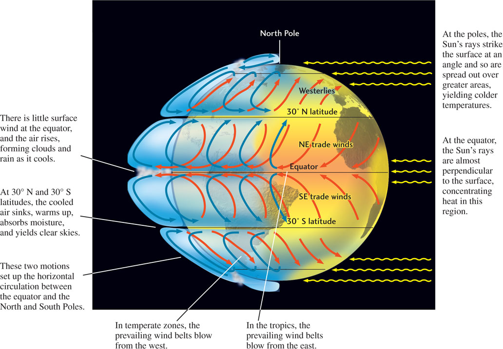
These prevailing wind belts arise because the Sun warms a given amount of land surface most intensely at the equator, where its rays are almost perpendicular to Earth’s surface. The Sun heats the land less intensely at high latitudes and at the poles because there its rays strike Earth’s surface at an angle. At the equator, hot air, which is less dense than cold air, rises and flows toward the poles, gradually sinking as it cools. The sinking air reaches ground level in the subtropics, at about 30° S and 30° N, then flows back along Earth’s surface toward the equator to form the trade winds. These air movements set up a global pattern of air circulation between the North and South Poles.
This simple circulatory pattern of air flow is complicated by Earth’s rotation, which deflects any current of air or water to the right in the Northern Hemisphere and to the left in the Southern Hemisphere. This effect is called the Coriolis effect, named after its discoverer. The Coriolis effect on atmospheric circulation deflects warm and cold air flows moving both northward and southward in both hemispheres. For example, as surface winds in the Northern Hemisphere blow southward into the hot equatorial belt, they are deflected to the right (westward) and hence blow from the northeast rather than from the north. These are the northeast trade winds. The Northern Hemisphere westerlies are flows of air that initially moved northward, but are deflected to the right (eastward) and thus blow from the southwest. Near the equator, air movement is mostly upward, so there is little wind at Earth’s surface.
531
As hot air rises at the equator, it cools and releases its moisture, causing the cloudiness and abundant rain of the tropics. This air, now cool and dry, warms and absorbs moisture as it sinks at about 30° N and 30° S latitude. Many of the world’s great deserts, such as the Sahara, lie at these latitudes. As the global climate changes, these belts of sinking dry air may also change, expanding and shifting their margins in some places and contracting them in others. In this way, a region bordering a desert—perhaps already suffering from a shortage of rain—may begin to emerge as a persistent desertlike environment. Eventually, the region may become part of the desert.