Wind as a Depositional Agent
When the wind dies down, it can no longer transport the sand and dust it carries. The coarser material is deposited in sand dunes of various shapes, ranging in size from low knolls to huge hills more than 100 m high (see the chapter opening photo). The finer dust falls to the ground as a more or less uniform blanket of silt and clay. By observing these depositional processes working today, geologists have been able to link them with observed characteristics, such as bedding and texture, in sandstones and dust deposits to deduce past climates and wind patterns.
Where Sand Dunes Form
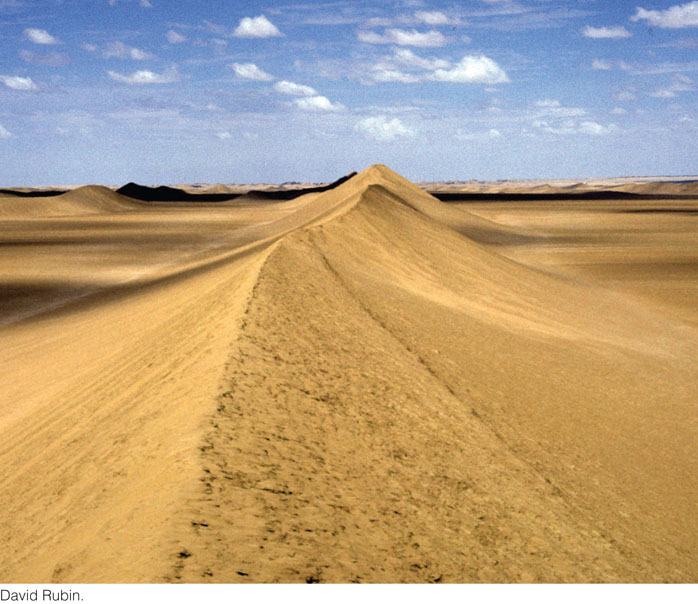
Sand dunes occur in relatively few environmental settings. Many North Americans have seen the dunes that form behind ocean beaches or along large lakes. Some dunes are found on the sandy floodplains of large rivers in semiarid and arid regions. Most spectacular are the fields of dunes that cover large expanses of some deserts (Figure 19.8). Such dunes may reach heights of 250 m, truly mountains of sand.
536
Dunes form only in settings that have a ready supply of loose sand: sandy beaches along coasts, sandy river bars or floodplain deposits in river valleys, and sandy bedrock formations in deserts. Another common factor in dune formation is wind power. On oceans and lakes, strong winds blow onshore from the water. Strong winds, sometimes of long duration, are common in deserts.
As we have seen, wind cannot pick up wet materials easily, so most dunes are found in dry climates. The exception is beaches along a coast, where sand is so abundant, and dries so quickly in the wind, that dunes can form even in humid climates. In such climates, soil and vegetation begin to cover the dunes only a little way inland from the beaches, and the winds no longer pick up the sand there.
Dunes may stabilize and become vegetated when the climate grows more humid, then start moving again when an arid climate returns. There is geologic evidence that during droughts two to three centuries ago and earlier, sand dunes in the western high plains of North America were reactivated and migrated over the plains.
How Sand Dunes Form and Move
The wind moves sand by sliding and rolling it along the surface and by saltation, the jumping motion that temporarily suspends grains in a current of water or air. Saltation in air flows works the same way as it does in streams (see Figure 18.15), except that the jumps in air flows are higher and longer. Sand grains suspended in an air current may rise to heights of 50 cm over a sand bed and 2 m over a pebbly surface—much higher than grains of the same size can jump in water. The difference arises partly from the fact that air is less viscous than water and therefore does not inhibit the bouncing of the grains as much as water does. In addition, the impact of grains falling in air induces higher jumps as they hit other grains on the surface. These collisions, which the air barely cushions, kick surface grains into the air in a sort of splashing effect. As saltating grains strike a sand bed, they can push forward grains too large to be thrown into the air, causing the bed to creep in the direction of the wind. A sand grain striking the surface at high speed can propel another grain as far as six times its own diameter.
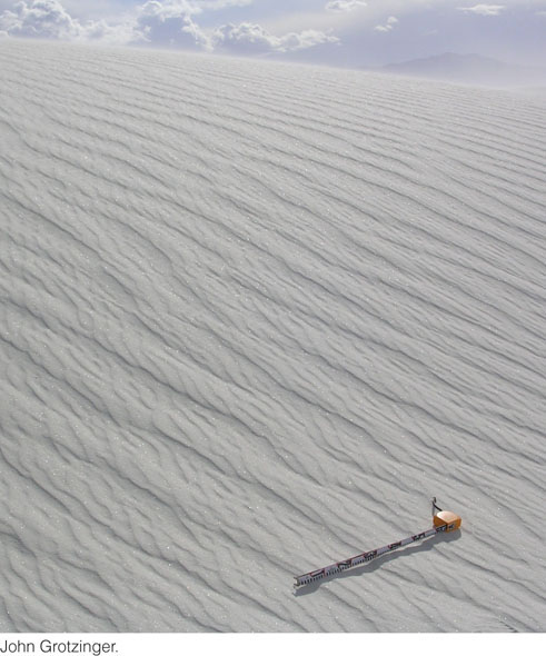
When wind moves sand along a bed, it almost inevitably produces ripples and dunes much like those formed by water (Figure 19.9). Ripples in dry sand, like those under water, are transverse; that is, at right angles to the current. At low to moderate wind speeds, small ripples form. As the wind speed increases, the ripples become larger. Ripples migrate in the direction of the wind over the backs of larger dunes. Some wind is almost always blowing, so a sand bed is almost always rippled to some extent.
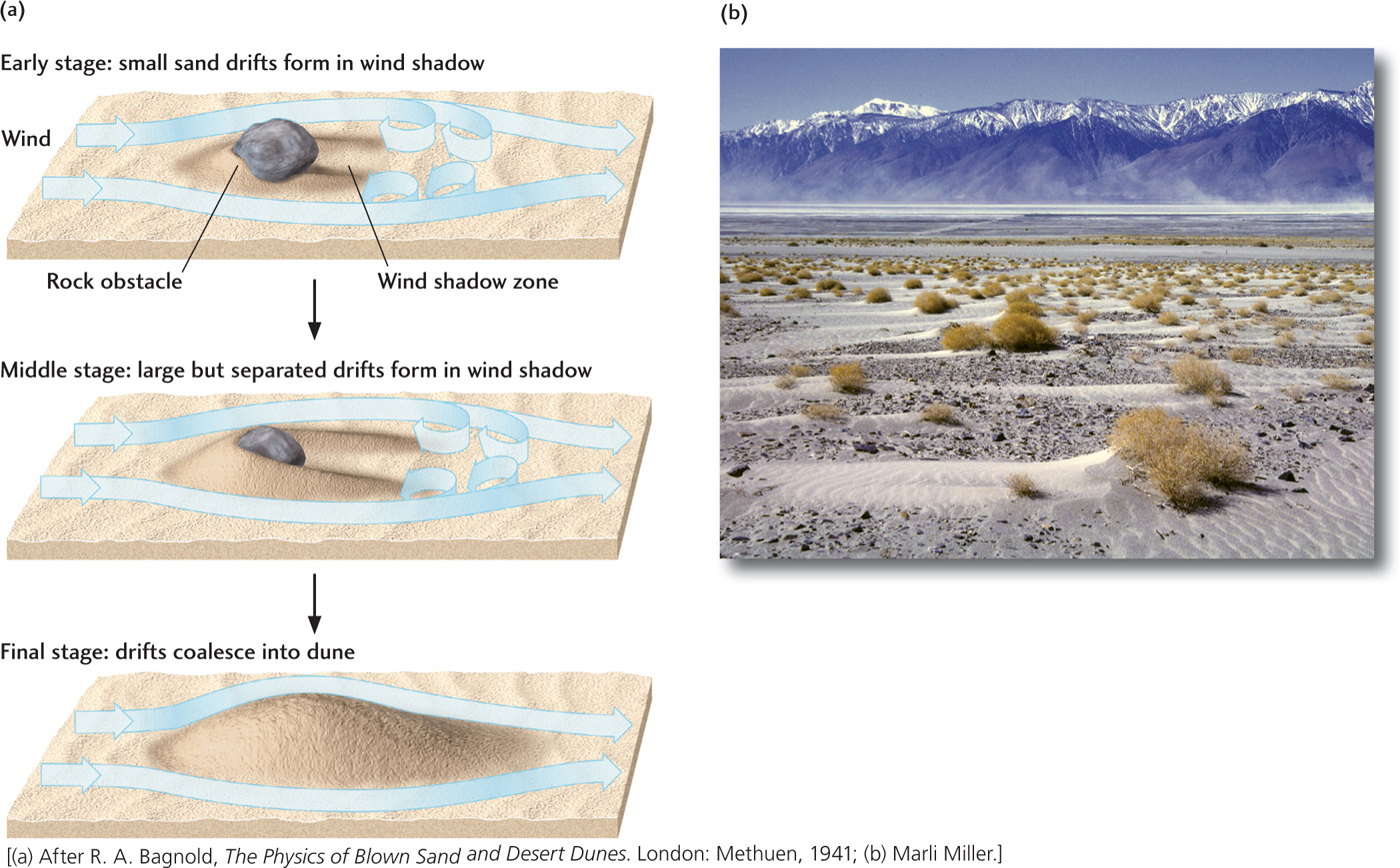
Given enough sand and wind, any obstacle—such as a large rock or a clump of vegetation—can start a dune. Streamlines of wind, like those of water, separate around the obstacle and rejoin downwind, creating a wind shadow downstream of the obstacle. Wind velocity is much lower in the wind shadow than in the main flow around the obstacle. In fact, it is low enough to allow sand grains blown into the wind shadow to settle there. The wind there is moving so slowly that it can no longer pick up these grains, and they accumulate as a sand drift, a small pile of sand in the lee of the obstacle (Figure 19.10). As the process continues, the sand drift itself becomes an obstacle. If there is enough sand, and the wind continues to blow in the same direction long enough, the sand drift grows into a dune. Dunes may also grow by the enlargement of ripples, just as underwater dunes do.
537
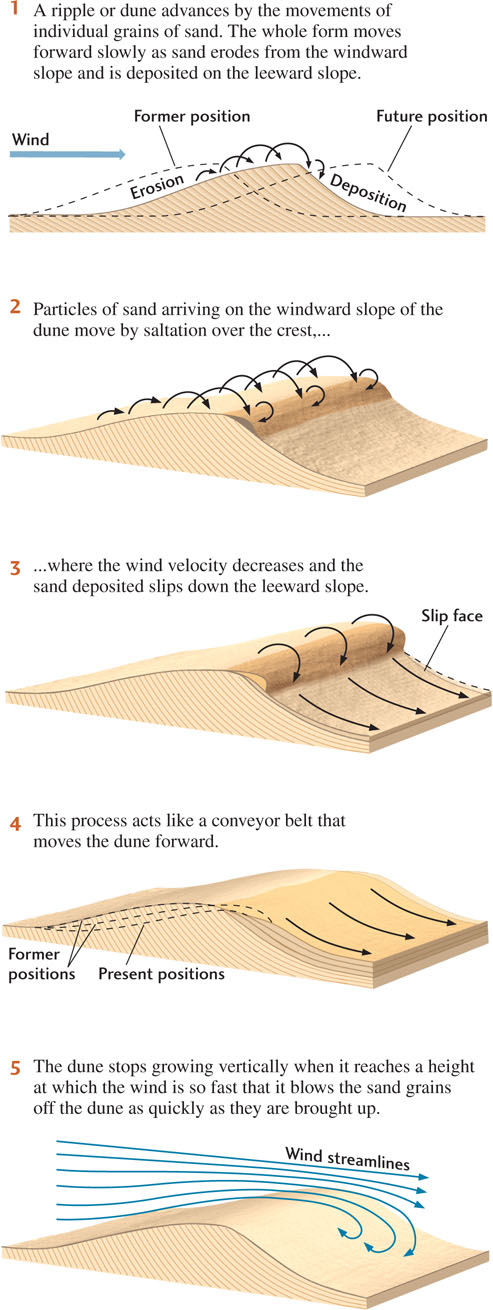
As a dune grows, it starts to migrate downwind through the combined movements of a host of individual grains. Sand grains constantly saltate to the top of the low-angled windward slope and then fall over into the wind shadow on the leeward slope, as shown in Figure 19.11. These grains gradually build up a steep, unstable accumulation on the upper part of the leeward slope. Periodically, the accumulation gives way and spontaneously slips or cascades down this slip face, as it is called, to a new slope at a lower angle. If we overlook these short-term, unstable steepenings of the slope, the slip face maintains a stable, constant slope angle—its angle of repose. As we saw in Chapter 16, the angle of repose increases with the size and angularity of the particles.
538
Successive slip face deposits at the angle of repose create the cross-bedding that is the hallmark of windblown dunes (see Figure 5.11). As dunes accumulate, interfere with one another, and become buried in a sedimentary sequence, the cross-bedding is preserved even though the original shapes of the dunes are lost. Sets of sandstone cross-beds many meters thick are evidence of high windblown dunes. From the directions of these eolian cross-beds, geologists can reconstruct wind directions of the past. Cross-bedding preserved on Mars (see Figure 9.28b) provides evidence of ancient windblown dunes there.
As more sand accumulates on the windward slope of a dune than blows off onto the slip face, the dune grows in height. Most dunes are meters to tens of meters in height, but the huge dunes of Saudi Arabia may reach 250 m, which seems to be the limit. The limit on dune height results from the relationship between wind streamline behavior, wind velocity, and topography. Wind streamlines advancing over the back of a dune become more compressed as the dune grows higher (see Figure 19.11). As more air rushes through a smaller space, the wind velocity increases. Ultimately, the air speed at the top of the dune becomes so great that sand grains blow off the top of the dune as quickly as they are brought up the windward slope. When this equilibrium is reached, the height of the dune remains constant.
Dune Types
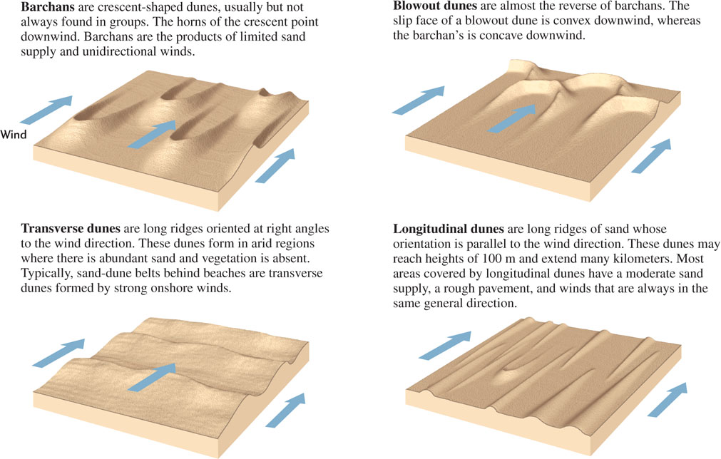
A person standing in the middle of a large expanse of dunes might be bewildered by the seemingly orderless array of undulating slopes. It takes a practiced eye to see the dominant pattern, and it may even require observation from the air. The general shapes and arrangements of sand dunes depend on the amount of sand available and the direction, duration, and strength of the wind. Geologists recognize four main types of dunes: barchans, blowout dunes, transverse dunes, and longitudinal dunes (Figure 19.12).
Dust Falls and Loess
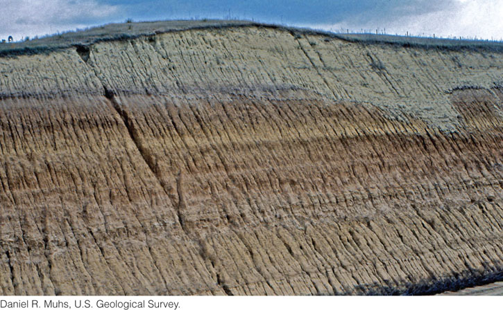
As the velocity of the wind decreases, the dust it carries in suspension settles to form loess, a blanket of sediment composed of fine-grained particles. Beds of loess lack internal stratification. In compacted deposits more than a meter thick, loess tends to form vertical cracks and to break off along sheer walls (Figure 19.13). Geologists theorize that the vertical cracking may be caused by a combination of root penetration and uniform downward percolation of groundwater, but the exact mechanisms are still unknown.
Loess covers as much as 10 percent of Earth’s land surface. The largest loess deposits are found in China and North America. China has more than a million square kilometers of loess deposits (Figure 19.14). Its greatest deposits extend over wide areas in the northwest; most are 30 to 100 m thick, although some exceed 300 m. The winds blowing over the Gobi Desert and the arid regions of central Asia provided the dust, which still blows over eastern Asia and the Chinese interior. Some of the loess deposits in China are over 2 million years old. They formed after an increase in the elevation of the Himalaya and related mountain belts in western China introduced rain shadows and dry climates to the continental interior. The uplift of these mountain belts was responsible for the cold, dry climates of the Pleistocene epoch in much of Asia. These climates inhibited vegetation and dried out soils, causing extensive wind erosion and transportation.

539
540
The best-known loess deposit in North America is in the upper Mississippi River valley. It originated as silt and clay deposited on the extensive floodplains of streams draining the edges of melting glaciers in the Pleistocene epoch. Strong winds dried the floodplains, whose frigid climate and rapid rates of sedimentation inhibited vegetation, and blew up tremendous amounts of dust, which then settled to the east. Geologists recognize that this loess deposit is distributed as a blanket of more or less uniform thickness on both hills and valleys, all in or near formerly glaciated areas. Changes in the regional thickness of the loess in relation to the prevailing westerly winds confirm its eolian origin. Its thickness on the eastern sides of major river floodplains is 8 to 30 m, greater than on the western sides, and decreases rapidly downwind to 1 to 2 m farther east of the floodplains.
Soils formed on loess are fertile and highly productive. Their cultivation poses environmental problems, however, because they are easily eroded into gullies by small streams and deflated by wind when they are poorly managed.