The Shaping of Shorelines
The effects of the coastal processes we have just described are best observed at shorelines. Waves, longshore currents, tidal currents, and storm surges interact with plate tectonic processes and with the geologic structures of the coast to shape shorelines into a multitude of forms. We can see these factors at work in the most popular of shoreline environments: beaches.
Beaches
A beach is a shoreline environment made up of sand and pebbles. The shape of a beach may change from day to day, week to week, season to season, and year to year. Waves and tides sometimes broaden and extend a beach by depositing sand and sometimes narrow it by carrying sand away.
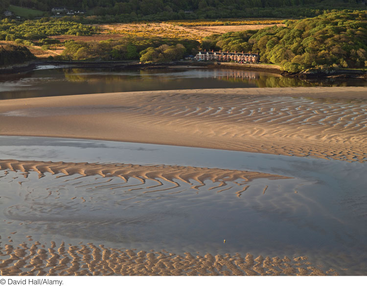
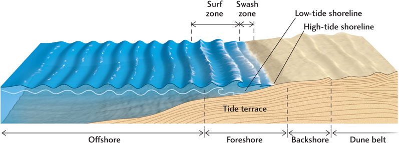
Many beaches are straight stretches of sand ranging from 1 km to more than 100 km long; others are smaller crescents of sand between rocky headlands. Belts of dunes border the landward edge of many beaches; bluffs or cliffs of sediment or rock border others. A beach may have a tide terrace—a flat, shallow area between the upper beach and an outer bar of sand—on its seaward side (Figure 20.12).
565
The Structure of a Beach
Figure 20.13 shows the major parts of a beach. These parts may not all be present at all times on any particular beach. Farthest out is the offshore, which is bounded by the surf zone, where the bottom begins to become shallow enough for waves to break. The foreshore includes the surf zone; the tide terrace; and, right at the shoreline, the swash zone, a slope dominated by the swash and backwash of the waves. The backshore extends from the swash zone up to the highest level of the beach.
The Sand Budget of a Beach
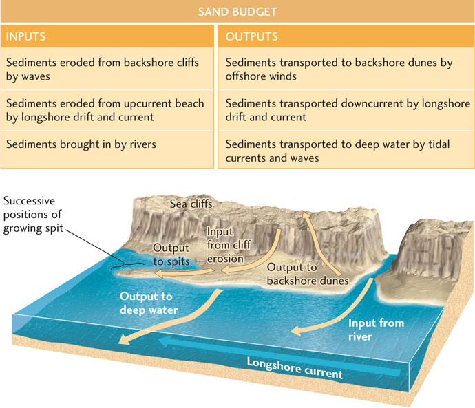
A beach is a scene of constant movement. Each wave moves sand back and forth with its swash and backwash. Both longshore drift and longshore currents move sand down the beach. At the end of the beach, and to some extent along it, sand is removed and deposited in deep water. In the backshore or along sea cliffs, sand and pebbles are freed by erosion and replenish the beach. Winds that blow over the beach transport sand, sometimes offshore into the water and sometimes onshore onto the land.
All these processes together maintain a balance between addition and removal of sand, resulting in a beach that may appear to be stable but is actually exchanging its material with the environments on all sides. Figure 20.14 illustrates the sand budget of a beach: the inputs and outputs caused by erosion, sedimentation, and transport. At any point along a beach, the beach gains sand from a number of sources: material eroded from the backshore; sand brought to the beach by longshore drift and longshore currents; and sediments carried to the shoreline by rivers. The beach also loses sand in a number of ways: winds carry sand to backshore dunes, longshore drift and longshore currents carry it downcurrent, and deep-water currents and waves transport it during storms.
566
If the total sand input balances the total sand output, the beach is in dynamic equilibrium, and it keeps the same general form. If input and output are not balanced, the beach grows or shrinks. Temporary imbalances are natural over weeks, months, or even years. A series of intense storms, for example, might move large amounts of sand from the beach to deeper waters offshore, narrowing the beach. Then, weeks of mild weather and low waves might move sand onto the shore and rebuild a wide beach. Without this constant shifting of sand, beaches might be unable to recover from the effects of trash, litter, and other kinds of pollution. Within a year or two, even oil from spills is transported or buried out of sight, although the tarry residue may later be uncovered in spots.
Some Common Forms of Beaches
Long, wide, sandy beaches grow where sand inputs are abundant, often where soft sediments make up the coast. Where the backshore is low and winds blow onshore, wide dune belts border the beach. Where the shoreline is tectonically elevated and the coast is made up of hard rock, cliffs line the shore, and any small beaches that form are composed of material eroded from those cliffs. Where the coast is low-lying, sand is abundant, and tidal currents are strong, extensive tidal flats are laid down and are exposed at low tide.
Preservation of Beaches
What happens if one of the inputs to a beach is cut off—for example, by a concrete seawall built along a beach to prevent erosion? Because erosion supplies sand to the beach, preventing erosion cuts the sand supply and so shrinks the beach. Such attempts to save a beach, undertaken without an understanding of its dynamic equilibrium, may actually destroy it.
Humans are altering the dynamic equilibrium of more and more beaches by placing buildings on them and erecting structures to protect them from erosion. We build cottages and resort hotels on the shore; pave beach parking lots; erect seawalls; and construct groins, piers, and breakwaters. The consequence of such poorly planned development is shrinkage of the beach in one place and its growth in another. As landowners and developers bring suit against one another and against state governments, trial lawyers take the issue of “sand rights”—the beach’s right to the sand that it naturally contains—into the courts.
To use a classic example, let’s examine what happens when a narrow groin or jetty—a structure built out from the shore at right angles to it—is installed. In the subsequent months and years, the sand disappears from the beach on one side of the groin and greatly enlarges the beach on the other side (Figure 20.15). These changes are the predictable result of normal coastal processes. The waves, longshore current, and longshore drift bring sand toward the groin from the upcurrent direction (usually the prevailing wind direction). Stopped at the groin, they dump the sand there. On the downcurrent side of the groin, the current and drift pick up again and erode the beach. On this side, however, replenishment of sand is sparse because the groin blocks inputs of sand. As a result, the sand budget is out of balance, and the beach shrinks. If the groin is removed, the beach returns to its former state.
567
The only way to preserve a beach is to leave it alone. Groins and seawalls are only temporary solutions to the problem of beach erosion, and even if they are kept in repair with large expenditures of money—many times at public expense—the beach itself will suffer. Beach restoration projects, which involve pumping large volumes of sand from offshore, have had some success (see Practicing Geology exercise), but they, too, are extremely costly. Sooner or later, we must learn to let beaches remain in their natural state.
Erosion and Deposition at Shorelines
The topography of shorelines is a product of the same forces that shape the continental interior: plate tectonic processes that elevate or depress Earth’s crust, erosional processes that wear it down, and sedimentation that fills in the low spots. Thus, several factors are directly at work:
 Tectonic uplift of the coastal region, which leads to erosional coastal forms
-
Tectonic subsidence of the coastal region, which leads to depositional coastal forms
-
The nature of the rocks or sediments at the shoreline
-
Changes in sea level, which affect the submergence or emergence of a shoreline
-
The average and storm wave heights, which affect erosion
-
The heights of the tides, which affect both erosion and sedimentation
Erosional Coastal Forms
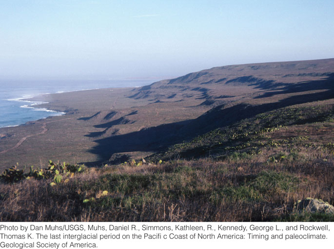
Erosion is an important process along uplifted rocky coasts. Along these coasts, prominent cliffs and headlands jut into the sea, alternating with narrow inlets and irregular bays with small beaches. Waves crash against the rocky shorelines, undercutting cliffs and causing huge blocks of rock to fall into the water, where they are gradually eroded away. As the sea cliffs retreat, isolated remnants called stacks may be left standing in the sea, far from the shore (see Figure 20.1c). Erosion by waves also planes the rocky surface beneath the surf zone and creates a wave-cut terrace, which is sometimes visible at low tide (Figure 20.16). Wave erosion over long periods may straighten shorelines as headlands are eroded faster than recesses and bays.
Where relatively soft sediments or sedimentary rocks make up the coastal region, slopes are gentler and the heights of shoreline bluffs are lower. Waves erode these softer materials efficiently, and erosion of bluffs on such shores may be extraordinarily rapid. The high sea cliffs of soft glacial sediments at the Cape Cod National Seashore in Massachusetts, for instance, are retreating about a meter each year. Since Henry David Thoreau walked the entire length of the beach below those cliffs in the mid--nineteenth century and wrote of his travels in Cape Cod, about 6 km2 of coastal land have been eaten away by the ocean, equivalent to about 150 m of beach retreat.
Our discussion of beaches illustrates the importance of erosional processes in those soft-sediment environments. In recent decades, more than 70 percent of the total length of the world’s sand beaches has retreated at a rate of at least 10 cm/year, and 20 percent has retreated at a rate of more than 1 m/year. Much of this loss can be traced to the damming of rivers, which decreases sediment input to the shoreline.
568
Depositional Coastal Forms
Sediments build up in areas where subsidence depresses Earth’s crust along a coastline. Such coastlines are characterized by wide, low-lying coastal plains of sedimentary rock and by long, wide beaches. Shoreline forms along these coastlines include sandbars, low-lying sandy islands, and extensive tidal flats. Long beaches grow longer as longshore currents carry sand to the downcurrent end of the beach. There it builds up, first forming a submerged sandbar, then rising above the surface and extending the beach by a narrow addition called a spit.
Offshore, long sandbars may build up into barrier islands that form a barricade between open-ocean waves and the main shoreline. Barrier islands are common, especially along low-lying coasts composed of small sediment particles that are easily eroded and transported, or of poorly cemented sedimentary rocks where longshore currents are strong. As the sand builds up above the waves, vegetation takes hold, stabilizing the islands and helping them resist wave erosion during storms. Barrier islands are separated from the coast by tidal flats or shallow lagoons. Like beaches on the main shore, barrier islands are maintained at a dynamic equilibrium by the forces shaping them. That equilibrium can be disturbed by natural changes in climate or in wave and current patterns, as well as by human activities. Disruption or devegetation can lead to increased erosion, and barrier islands may even disappear beneath the sea surface. Barrier islands may also grow larger and more stable if sedimentation increases.
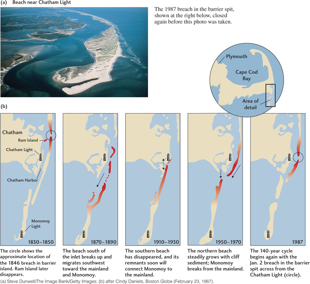
Over hundreds of years, sandy shorelines may undergo significant changes. Hurricanes and other intense storms may form new inlets, elongate spits, or breach existing spits and barrier islands. Such changes have been documented by aerial photographs taken at various time intervals. The shoreline of Chatham, Massachusetts, at the elbow of Cape Cod, has changed enough in the past 160 years or so that a lighthouse has had to be moved. Figure 20.17 illustrates the many changes that have taken place in the configuration of the barrier islands to the north and to the long spit of Monomoy Island, including several breaches of the barrier islands. Many homes in Chatham are now at risk, but there is little that the residents or the state can do to prevent coastal processes from taking their natural course.
Effects of Sea Level Change
The shorelines of the world serve as barometers for impending changes caused by many types of human activities. The pollution of our inland waterways sooner or later arrives at our beaches, just as sewage from city dumping and oil from oceangoing tankers wash up on the shore. As real estate development and construction along shorelines expands, we will see the continuing contraction, and even the disappearance, of some of our finest beaches. As global warming and glacial melting cause sea level to rise, we will see the effects of that change on our shorelines as well.
569
Shorelines are particularly sensitive to changes in sea level, which can alter tidal heights, change the approach patterns of waves, and affect the paths of longshore currents. The rise and fall of sea level at a shoreline can be local—the result of tectonic subsidence or uplift—or global—the result of glacial melting or growth. One of the primary concerns about human-induced global warming is its potential for causing sea level rises that will flood coastal cities, as we will see in Chapter 21.
In periods of globally lowered sea level, areas that were offshore are exposed to agents of erosion. Rivers extend their channels over formerly submerged regions and cut valleys into newly exposed coastal plains. When sea level rises, flooding the backshore, marine sediments build up along former land areas, erosion is replaced by sedimentation, and river valleys are submerged. Today, long fingers of the sea indent many of the shorelines of the northern and central Atlantic coast of North America. These long indentations are former river valleys that were flooded as the last ice age ended about 11,000 years ago and sea level rose.
570
Sea level variations on geologic time scales can be measured by studies of wave-cut terraces (see Figure 20.16), but detecting global sea level changes on shorter (human) time scales is more difficult. Local changes can be measured by using a tide gauge that records sea level relative to a land-based benchmark. The major problem with this approach is that the land itself moves vertically as a result of deformation, sedimentation, and other geologic processes, and this movement is incorporated into the tide-gauge observations. A newer method of tracking sea level changes makes use of an altimeter mounted on a satellite. The altimeter sends pulses of radar beams that are reflected off the ocean surface, providing measurements of the elevation of the ocean surface relative to the orbit of the satellite with a precision of a few centimeters.
Using these methods, oceanographers have determined that global sea level has risen by 17 cm over the last century, and is continuing to rise about 3 mm/year. This recent increase in sea level correlates with a worldwide increase in average global temperatures, which most scientists now believe has been caused, at least in part, by anthropogenic emissions of greenhouse gases (see Chapter 23). Some of the rise may result from short-term variations, but the magnitude of the rise is consistent with climate models that take greenhouse warming into account. These models predict that without significant worldwide efforts to reduce greenhouse gas emissions, sea level will rise by another 3100 cm during the twenty-first century.