Topography of the Deep Seafloor
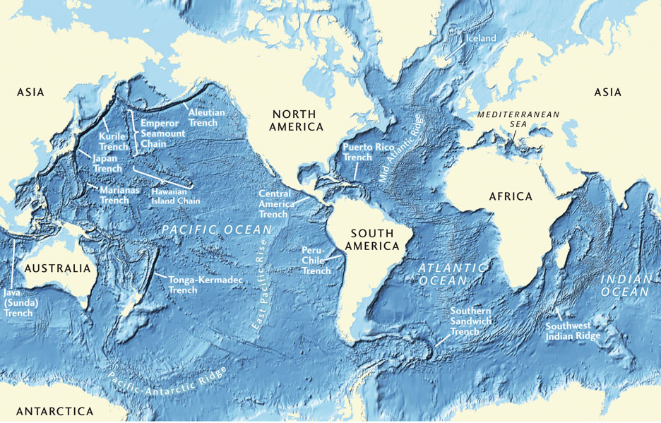
A topographic map of Earth’s ocean basins (Figure 20.20) reveals the most important geologic features submerged beneath the oceans: mid-ocean ridges, volcanic tracks of hot spots, deep-sea trenches, island arcs, and continental margins.
Making a map of the deep seafloor is no easy task. Because sunlight can penetrate only 100 m or so below the ocean surface, the deep ocean is a very dark place. It is not possible to map the seafloor using visible light, nor can we use radar beamed from spacecraft, which we have used to map the surface of cloud-shrouded Venus. Ironically, remote sensing from spacecraft has allowed us to map the surfaces of our planetary neighbors with much higher resolution than we have been able to do for Earth’s deep seafloor, even to this day.
Probing the Seafloor from Surface Ships
It is possible for scientists to view the seafloor directly from a deep-diving submersible. These small submarines can observe and photograph the seafloor at great depths (Figure 20.21). With their mechanical arms, they can break off pieces of rock, sample soft sediments, and capture specimens of exotic deep-sea animals. Newer robotic submersibles can be guided by scientists on a mother ship at the surface. But submersibles of either type are expensive to build and operate, and they cover small areas at best.
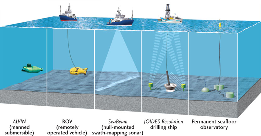
For most work, today’s oceanographers use instrumentation on ships at the surface to sense the seafloor topography indirectly. Echo sounders (also known as sonar), developed in the early part of the twentieth century, send out pulses of sound waves; when those waves are reflected back from the ocean bottom, they are picked up by sensitive microphones in the water. Oceanographers can measure depth by determining the interval between the time a pulse leaves the device and the time it returns as a reflection. The result is an automatically traced profile of the seafloor. Powerful echo sounders are also used to probe the stratigraphy of sedimentary layers beneath the seafloor (see Figure 14.6).
573
574
575
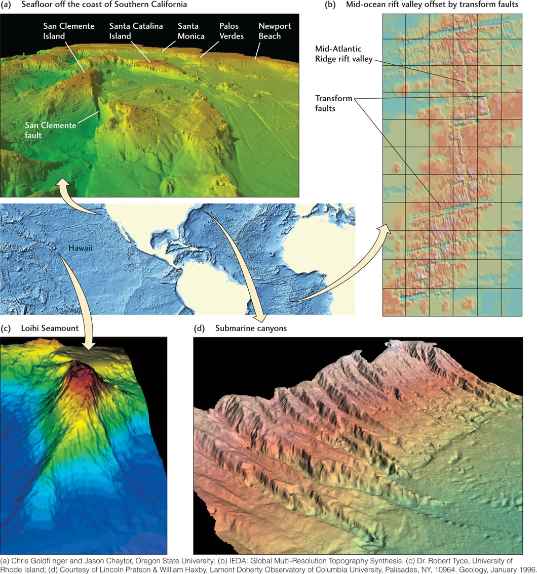
Many of today’s oceanographic vessels are outfitted with hull-mounted sonar arrays that can reconstruct a detailed image of seafloor topography in a swath extending as much as 10 km on either side of the ship as it steams along (see Figure 20.21). These systems can map the seafloor with unprecedented resolution of small-scale geologic features, such as undersea volcanoes, canyons, and faults. Figure 20.22 shows several impressive images of the seafloor derived by this type of mapping.
Other types of instruments can be towed behind a ship or lowered to the bottom to evaluate the magnetism of the seafloor, the shapes of undersea cliffs and mountains, and the heat coming from the crust. Underwater cameras on sleds towed near the ocean bottom can photograph the details of the seafloor and the organisms that inhabit the deep sea. Since 1968, the U.S. Deep Sea Drilling Project and its successor, the international Ocean Drilling Program, have sunk hundreds of drill holes to depths of many hundreds of meters below the seafloor. Cores obtained from these drill holes have provided geologists with sediment and rock samples for detailed physical and chemical studies.
Charting the Seafloor by Satellite
Despite all this fancy gear, there are still many regions of the oceans that have not been surveyed, and our knowledge of the seafloor remains fragmentary. Recently, however, satellite altimeters have been used to chart the global topography of the seafloor indirectly. The elevation of the ocean surface depends not only on waves and ocean currents, but also on variations in gravity caused by the topography and composition of the underlying seafloor. The gravitational attraction of a seamount, for example, can cause water to “pile up” above it, producing a bulge in the ocean surface of as much as 2 m above average sea level. Similarly, the diminished gravity over a deep-sea trench is evident as a depression in the ocean surface of as much as 60 m below average sea level.
This method has allowed us to infer features of the seafloor from satellite data and display them as if the seas were drained away. Marine geologists have used this technique to map new features of the seafloor not revealed by ship surveys, especially in the poorly surveyed southern oceans. The satellite data have also revealed deeper structures below the oceanic crust, including gravity anomalies associated with convection currents in the mantle, as described in Chapter 14.
Profiles Across Two Oceans
To gain an appreciation of the geologic features that lie beneath the oceans, let’s take a brief tour across two of Earth’s major ocean basins, the Atlantic and the Pacific. We’ll travel across these ocean basins as if we were driving a deep--diving submersible along the seafloor.
An Atlantic Profile
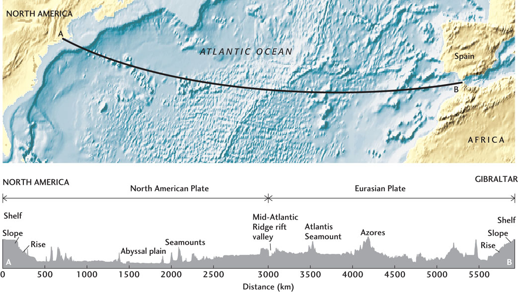
The Atlantic profile shown in Figure 20.23 extends from North America to Gibraltar. Starting from the coast of New England, we descend from the shoreline to depths of 50 to 200 m and travel eastward across the continental shelf. After traveling about 50 to 100 km down a very gently inclined surface, we find ourselves at the edge of the shelf. There, we start down a steeper incline, the continental slope. This mud-covered slope descends at an angle of about 48, a drop of 70 m over a horizontal distance of 1 km, which would be a noticeable grade if we were driving on land.
576
The continental slope is irregular and is marked by gullies and submarine canyons eroded into the slope and the shelf behind it (see Figure 20.22d). On the lower parts of the slope, at depths of about 2000 to 3000 m, the downward incline becomes gentler as we reach the continental rise.
The continental rise is tens to hundreds of kilometers wide, and it grades imperceptibly into the wide, flat abyssal plain at depths of about 4000 to 6000 m. The plain is broken by occasional submerged volcanoes, mostly extinct, called seamounts. As we travel along the abyssal plain, we gradually climb into a province of low abyssal hills whose slopes are covered with fine-grained sediments. As we continue up the hills, the sediment layer becomes thinner, and outcrops of basalt appear beneath it. As we rise along this steep, irregular topography to depths of about 3000 m, we are climbing the flanks and then the mountains of the Mid-Atlantic Ridge.
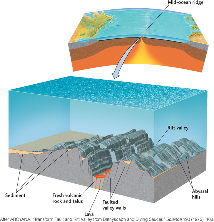
Abruptly, we come to the edge of a deep, narrow valley a few kilometers wide at the top of the ridge (Figure 20.24). This narrow cleft, marked by active volcanism, is the rift valley where two plates separate. As we cross the valley and climb its eastern side, we move from the North American Plate to the Eurasian Plate. Continuing eastward, we encounter topography similar to that on the western side of the ridge, only in reverse order, because the seafloor is more or less symmetrical on either side of the ridge. Passing over the rough topography of the abyssal hills on the flank of the Mid-Atlantic Ridge, we descend to the abyssal plain and then travel up the continental rise, slope, and shelf off the coast of Europe. On the path we have taken, this symmetry is disturbed by some large seamounts and the volcanic islands of the Azores, which mark an active hot spot, perhaps caused by the heat from an upwelling mantle plume.
577
A Pacific Profile
Our second virtual tour moves westward across the Pacific, from South America to Australia (Figure 20.25). Beginning on the west coast of Chile, we cross a narrow continental shelf only a few tens of kilometers wide. At the edge of the shelf, we plunge down a continental slope that is much steeper than the one we traversed in the Atlantic, extending down to 8000 m as we enter the Peru-Chile Trench. This long, deep, narrow depression of the seafloor is the surface expression of the subduction of the Nazca Plate under the South American Plate.
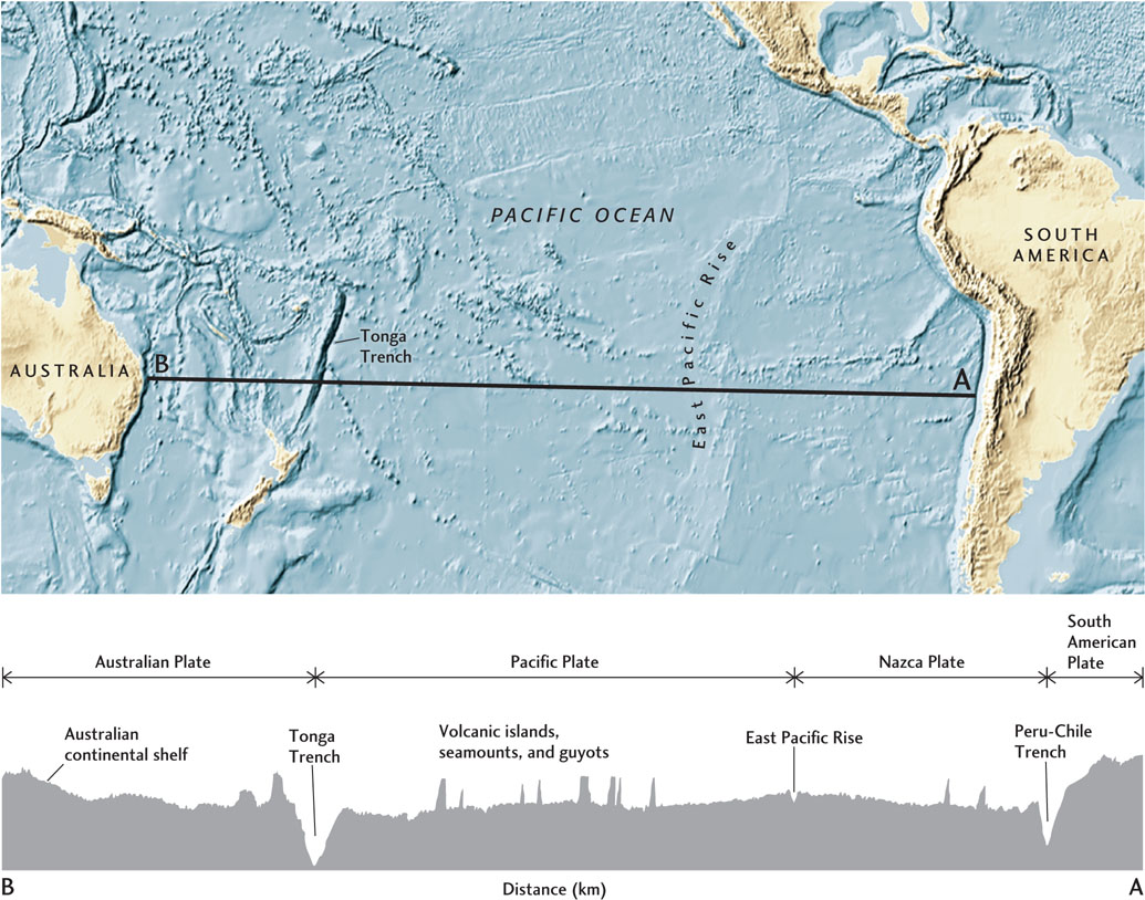
Continuing across the trench and up onto the abyssal hills of the Nazca Plate, we come to the East Pacific Rise, an active mid-ocean ridge. The East Pacific Rise is lower than the Mid-Atlantic Ridge, and its rate of seafloor spreading is the world’s fastest—at about 150 mm/year, more than six times faster than that of the Mid-Atlantic Ridge—but it has the characteristic central rift valley and outcrops of fresh basalt. We cross over to the Pacific Plate, on the western side of the East Pacific Rise, and travel westward over its broad central regions, which are studded with seamounts and volcanic islands.
We eventually arrive at another subduction zone, marked by the Tonga Trench, where the Pacific Plate sinks into the mantle beneath the Australian Plate. This is one of the deepest places in the world ocean, almost 11,000 m below the ocean surface. On the western side of the trench, the seafloor rises to form the volcanic islands of Tonga and Fiji. Beyond this island arc, we return to the abyssal plain, now on the Australian Plate, and come to the continental rise, slope, and shelf of eastern Australia, which has a profile similar to that of the east coast of North America.
578
Main Features of the Deep Seafloor
Away from continental margins and subduction zones, the deep seafloor is constructed primarily by volcanism related to seafloor spreading and secondarily by sedimentation in the open ocean.
Mid-Ocean Ridges
Mid-ocean ridges are the sites of the most intense volcanic and tectonic activity on the deep seafloor. The main rift valley is the center of the action. The valley walls are faulted and intruded by basaltic sills and dikes (see Figure 20.24), and the floor of the valley is covered with flows of basalt and talus from the valley walls, mixed with small amounts of sediment that have settled from surface waters.
Hydrothermal vents form on the rift valley floor as seawater percolates into fractures in the basalt on the flanks of the ridges, is heated as it flows downward to encounter hotter basalt, and finally exits at the valley floor (see Figure 12.22). There, it boils up at temperatures as high as 380°C. Some springs are “black smokers,” full of dissolved hydrogen sulfide and metals that the hot water has leached from the basalt (see Figure 11.15). Others are cooler “white smokers” that release various compounds of barium, calcium, and silicon. Both black smokers and white smokers produce mounds of iron-rich clay minerals, iron and manganese oxides, and large deposits of iron–zinc–copper sulfides.
Mid-ocean ridges are offset at many places by transform faults that displace the rift valleys laterally (see Figure 20.22b). Large earthquakes occur on these faults as one plate slips past the other. Rocks collected from the walls of the transform faults often have the olivine-rich compositions typical of the mantle, rather than the basaltic composition of oceanic crust. This observation suggests that the igneous process that creates oceanic crust may operate less efficiently where the spreading center abuts a fault.
Abyssal Hills and Plains
The deep seafloor away from the mid-ocean ridges is a landscape of hills, plateaus, sediment-floored basins, and seamounts. Abyssal hills are ubiquitous on the slopes of mid-ocean ridges. They are typically 100 m or so high and lined up parallel to the ridge crest (see Figure 20.24). They are formed primarily by normal faulting of the newly formed oceanic crust as it moves out of the rift valley. Almost all of this faulting occurs during the first million years of the crust’s existence, after which the faults bounding the hills become inactive.
As the new oceanic crust drifts away from the spreading center, it cools and contracts, lowering the seafloor. Its hilly, subsiding surface receives a steady rain of sediments from surface waters, gradually becoming covered with deep-sea muds and other deposits. Near the continental margins, terrigenous sediments moving down the continental slopes add to this sediment cover and create the flat, unbroken expanses of the abyssal plains. These plains are the flattest solid surfaces on the planet.
Seamounts, Hot-Spot Island Chains, and Plateaus
The seafloor is littered with tens of thousands of volcanoes. Most are submerged seamounts, but some rise above the ocean surface as volcanic islands. Seamounts and volcanic islands may be isolated or found in clusters or chains. Most seamounts, though not all, are created by eruptions near active spreading centers or where a plate overrides a hot spot.
Some of the larger seamounts, called guyots, have flat tops, the result of erosion that occurred when they were volcanic islands. These islands later became submerged as the plate on which they ride cooled, contracted, and subsided as it moved away from the spreading center or hot spot that formed them.
Among the most surprising features of deep ocean basins are large basalt plateaus. Some appear to have formed near triple junctions where three spreading centers meet. Others are associated with massive eruptions at hot spots far from spreading centers. Some scientists believe that deep-sea basalt plateaus of the latter type, like continental flood basalts, can be explained by the mantle plume hypothesis (see Chapter 12).