How Glaciers Move
When ice becomes thick enough for gravity to overcome its resistance to movement—normally at least several tens of meters—it starts to flow, and thus becomes a glacier. The ice in a glacier moves downhill in the same kind of laminar flow as a slowly flowing stream of water (see Figure 18.14). Unlike the readily observed flow of a stream, however, glacial movement is so slow that the ice seems not to move at all from day to day, giving rise to the expression “moving at a glacial pace.”
Mechanisms of Glacial Flow
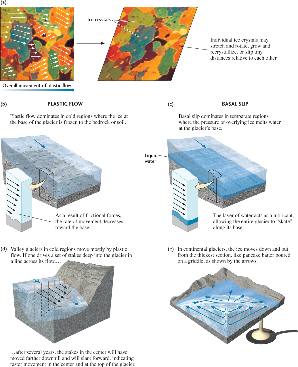
The flow of glaciers occurs in two ways: by plastic flow and by basal slip (Figure 21.10). In plastic flow, the movement occurs as deformation within the glacier. In basal slip, the glacier slides downslope as a single unit along its base, like a block of ice sliding down a ramp.
Movement By Plastic Flow
The force of gravity exerted on a glacier causes individual crystals of ice to slip tiny distances relative to each other—on the order of a ten-millionth of a millimeter—over short intervals (Figure 21.10a). The sum of many such movements among the enormous number of ice crystals that make up a glacier deforms the whole mass of ice in a process known as plastic flow. To visualize this process, think of a random pile of playing cards; the whole pile can be made to shift by inducing small slips on the many surfaces between cards. As ice crystals grow under pressure deeper in the glacier, their microscopic slip planes become more parallel, increasing plastic flow rates.
Plastic flow is most important in very cold regions, where the ice throughout the glacier, including its base, is well below the freezing point and the basal ice is frozen to the ground (Figure 21.10b). Most of the movement of these cold, dry glaciers takes place above the base by plastic flow. Movements near the frozen base detach and transport pieces of bedrock and soil. Because of this mixing of rock material with ice, the interface between the overlying ice and the underlying ground is usually not a sharp boundary, especially where the ground consists of sediments or weak sedimentary rocks. Instead, the interface becomes a transition between ice loaded with debris and deformed ground containing appreciable ice.
Movement By Basal Slip
The other mechanism of glacial movement is basal slip, the sliding of a glacier along the boundary between the ice and the ground (Figure 21.10c). The melting point of ice decreases as pressure increases, so ice at the base of a glacier, where the weight of the overlying ice is greatest, melts at a lower temperature than ice within the glacier. The melted ice lubricates the base of the glacier, causing it to slip downslope. This same effect helps make ice skating possible: the weight of the body on the narrow skate blade provides enough pressure to melt just a little ice under the blade, which lubricates the blade so that it can slide easily along the surface.
In temperate regions, where the air temperature is above freezing during parts of the year, ice may be at the melting point within a glacier as well as at its base. Plastic flow contributes a small amount of internal heating from the friction generated by microscopic slips of ice crystals. In these glaciers, water occurs within the ice as small drops between crystals. Water seeping through cracks in the ice forms pools or streams of meltwater that carve tunnels in the ice. The water throughout the glacier eases internal slip between layers of ice.
Flow in Valley Glaciers
Louis Agassiz, a nineteenth-century Swiss zoologist and geologist, was the first to precisely measure how a valley glacier moves. As a young professor in the 1830s, he pounded stakes into a glacier in the Swiss Alps and measured their positions over several years. He observed that the stakes along the centerline of the glacier moved the fastest, at about 75 m/year, whereas the stakes nearer the valley walls traveled more slowly. Later, the deformation of long vertical tubes pounded deep into the glacier demonstrated that ice near the base flowed more slowly than ice in the center.
This type of deformation, in which the central part of a glacier moves faster than its sides or its base, is diagnostic of plastic flow (Figure 21.10d). Other valley glaciers have been observed to move at more uniform speeds, sliding as a single unit almost entirely by basal slip along a lubricating layer of meltwater next to the ground. Most often, however, valley glaciers flow by a combination of mechanisms—partly by plastic flow within the mass of ice and partly by basal slip.
A sudden period of fast movement of a valley glacier, called a surge, sometimes occurs after a long period of little movement. Surges may last several years, and during that time the ice may speed along at more than 6 km/year—a thousand times the normal velocity of a glacier. In many cases, surges follow the buildup of water pressure at or near the base of the glacier. This pressurized water greatly enhances basal slip.
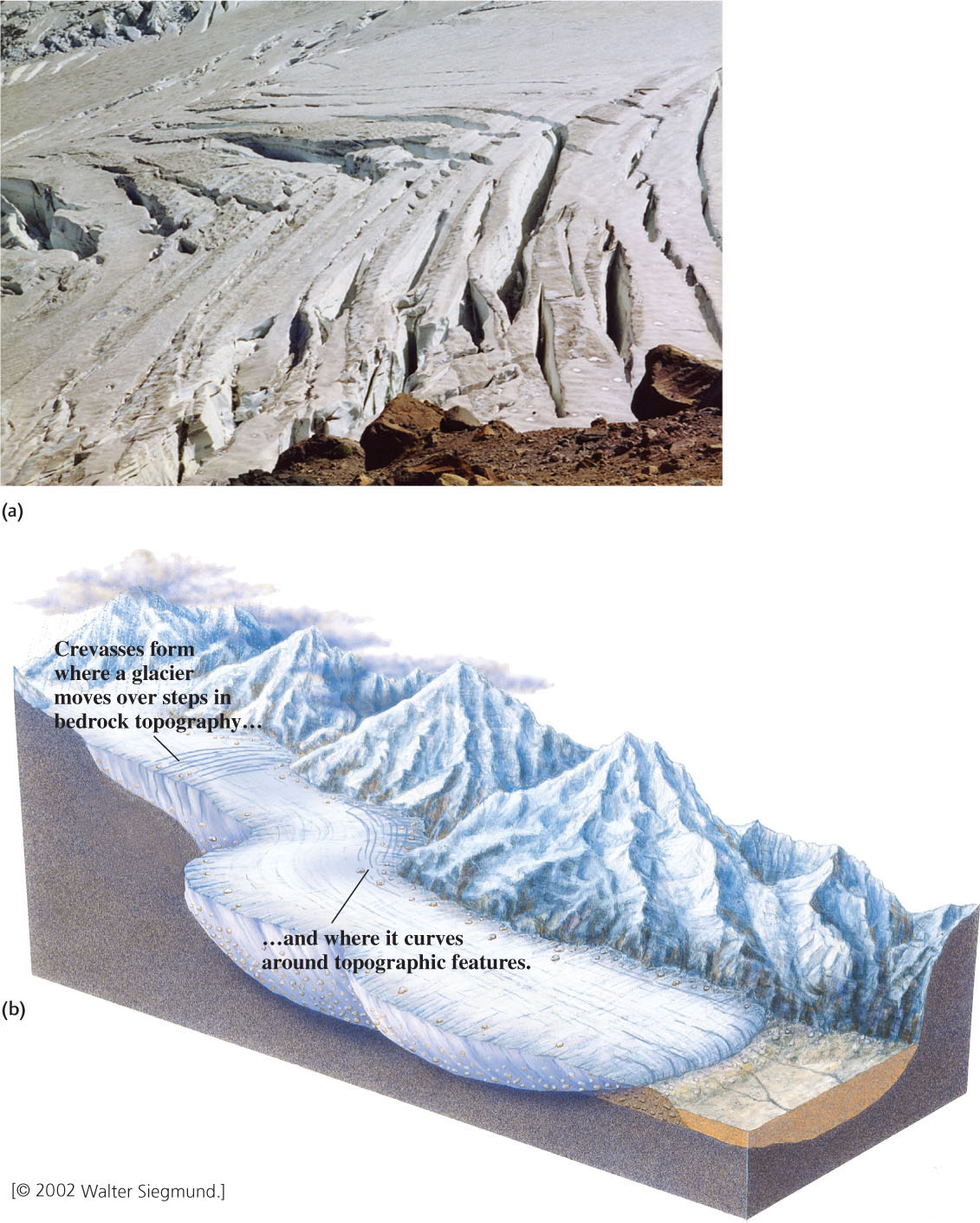
The upper parts of a glacier have little pressure on them. At these low pressures, the ice at the surface of the glacier (shallower than about 50 m) behaves as a rigid, brittle solid, cracking as it is dragged along by the plastic flow of the ice below. The cracks, called crevasses, break up the surface ice into many small and large blocks (Figure 21.11). Crevasses are most likely to occur in places where glacial deformation is strong—such as where the ice drags against the valley walls at curves in the valley, at irregularities in the valley floor, and where the slope steepens sharply. The movement of brittle surface ice at these places is a “flow” resulting from slipping movements across the surfaces of these irregular blocks, similar in some ways to faulting in crustal rocks.
Antarctica in Motion
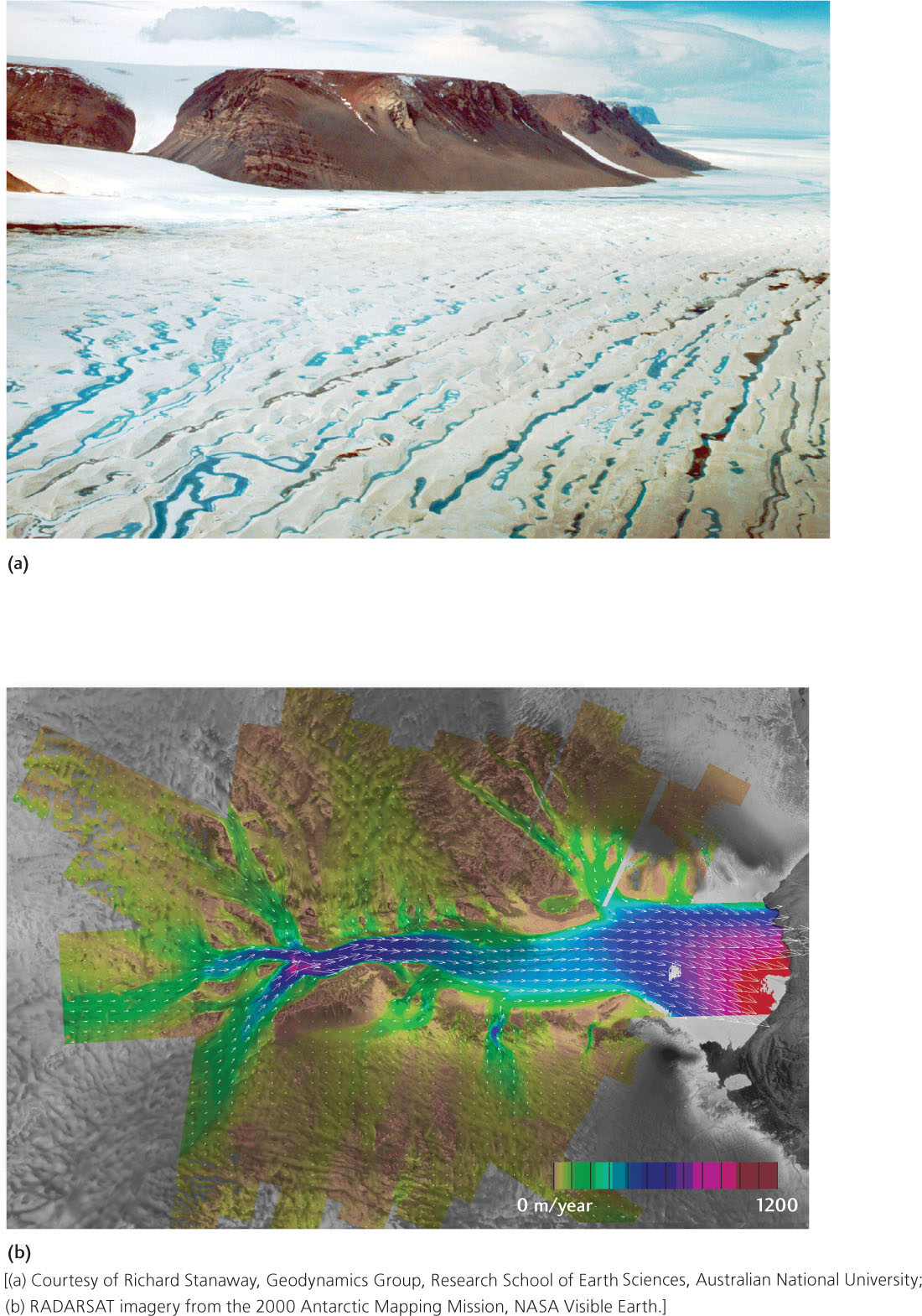
Antarctica may appear to be a land frozen in time, but it certainly does not stand still. Glaciers plow downward from the continent’s center to the ocean, icebergs snap off and crash into the ocean, and great rivers of ice snake through the ice sheet. All these movements provide evidence of the dynamic relationship between this remote continent and the global climate system. Continental glaciers in polar climates, where basal slip is minor or absent in most places, have their highest rates of movement in the center of the ice. Pressure there is high, and the main force retarding movement is the friction between layers of ice moving at different speeds (Figure 21.10e).
595
596
Geologists use satellites and airborne radar to map the shapes and overall movements of glaciers. These measurements show that Antarctic glaciers flow rapidly in ice streams 25 to 80 km wide and 300 to 500 km long (Figure 21.12). These streams reach velocities of 0.3 to 2.3 m/day, compared with the flow rate of 0.02 m/day in the adjacent ice sheet. Boreholes drilled in the ice reveal that the base of the ice stream is at the melting point and that the meltwater is mixed with soft sediment. One theory is that the rapid movement of ice streams is related to deformation of the water-saturated basal sediment. Ice streams may form during climate warming, leading to ice breakup and rapid deglaciation. In the current period of global warming, they may be contributing to the retreat of glaciers and the instability of the ice sheet in West Antarctica.
597
598
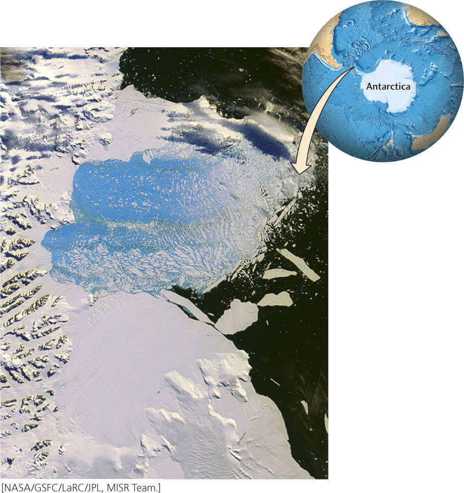
Using high-resolution radar satellite mapping, geologists have observed that several Antarctic glaciers have retreated more than 30 km in just 3 years. Over the past 20 years or so, enormous pieces of ice have snapped off Antarctic glaciers. In March 2000, an iceberg slightly less than 10,000 km2 (larger than the state of Delaware) calved from the Ross Ice Shelf. In February and March of 2002, a portion of the Larsen Ice Shelf larger than Rhode Island (about 3250 km2) shattered and separated from the northeastern side of the Antarctic Peninsula (Figure 21.13). The fracturing of this piece of the ice sheet produced thousands of icebergs.
Geologists who monitor the Larsen Ice Shelf were able to predict this episode of ice shelf collapse. Field and satellite-based observations showed that the flow rate of the ice stream leading to it had increased dramatically, which was interpreted as a sign of instability. After the collapse of the ice shelf, the flow rate of the ice stream increased further. In general, the destruction of ice shelves tends to destabilize the continental glaciers that feed them, causing the glaciers to flow more rapidly into the oceans.
Ice shelf instabilities are increasing in size and frequency at an alarming rate. The latest example is the Wilkins Ice Shelf, which occupies an area of 14,000 km2 on the southwestern side of the Antarctic Peninsula. It began to break apart in early 2008 and, as of 2013, appears to be on the verge of further collapse. Although these collapses are a worrisome symptom of global warming, they will not, by themselves, contribute to sea level rise (see Earth Issues 21.1).