Glacial Cycles and Climate Change
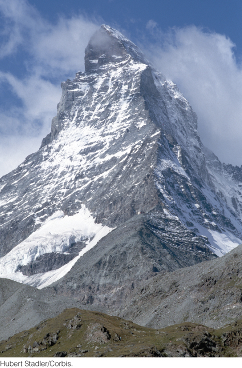
Louis Agassiz, the same geologist who first measured the speed of a Swiss valley glacier, was the first to propose (in 1837) that the glaciers he observed in the Alps must have been much larger and thicker in the geologically recent past. He suggested that during a past ice age, Switzerland was covered by an extensive continental glacier almost as thick as its mountains were tall, similar to the one in Greenland today. Among the evidence he cited was the obvious glacial sculpting of high Alpine peaks such as the mighty Matterhorn (Figure 21.22). Agassiz’s hypothesis was controversial and was not immediately accepted.
607
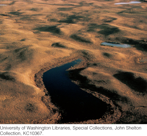
Agassiz emigrated to the United States in 1846 and became a professor at Harvard University, where he continued his studies in geology and other sciences. His research took him to many places in the northern parts of Europe and North America, from the mountains of Scandinavia and New England to the rolling hills of the American Midwest. In all these diverse regions, Agassiz saw signs of glacial erosion and sedimentation. In the flat country of the American Great Plains, he observed deposits of glacial drift that reminded him of the end moraines of Swiss valley glaciers (Figure 21.23). The heterogeneous material of the drift, including erratic boulders, convinced him of its glacial origin, and the freshness of the soft sediments indicated that they were deposited in the recent past.
The areas covered by this drift were so vast that the ice that deposited them must have been a continental glacier much larger than the ones that now cover Greenland and Antarctica. Agassiz expanded his ice age hypothesis, proposing that a great continental glaciation had extended the polar ice caps far into regions that now enjoy more temperate climates. For the first time, people began to talk seriously about ice ages.
The Wisconsin Glaciation
Geologists have determined the ages of the glacial sediments Agassiz studied by isotopic dating, using carbon-14 in logs buried in the drift. The most recent drift was deposited by ice during the latter part of the Pleistocene epoch. Along the east coast of the United States, the southernmost advance of this ice is recorded by the enormous terminal moraines that form Long Island and Cape Cod. North American geologists named this glaciation after Wisconsin because its effects are particularly well manifested in the glacial terrains of that state. The Wisconsin glaciation reached its maximum 21,000 to 18,000 years ago. Figure 21.24 shows the distribution of ice near the end of the glacial maximum.
608
The Wisconsin glaciation was a global event, though geologists in various parts of the world have therefore given it their own local names (calling it the Würm glaciation in the Alps, for example). Ice sheets with thicknesses of 2 to 3 km built up over the northern parts of North America, Europe, and Asia. In the Southern Hemisphere, the Antarctic ice sheet expanded, and the southern tips of South America and Africa were covered with ice.
Glaciation and Sea Level Change
At the Wisconsin glacial maximum, the continents were slightly larger than they are today because the continental shelves surrounding them—some more than 100 km wide—were exposed by a drop in sea level of about 130 m (see Figure 15.11). This drop in sea level was due to the enormous amount of water transferred from the hydrosphere to the cryosphere. Rivers extended across the newly emergent continental shelves and began to erode channels in the former seafloor. Early cultures, such as those of prehistoric Egypt, were evolving in the lands beyond the ice sheets, and humans lived in these low coastal plains.
609
The relationship between sea level change and glacial cycles illustrates the interaction of the hydrosphere and the cryosphere within the climate system (see Chapter 15). As Earth warms or cools, the volume of the cryosphere shrinks or grows. However, as a result of isostasy, only changes in the ice volume on continents directly affect sea level (see Earth Issues 21.1). As continental glaciers grow, the volume of the ocean decreases, and sea level falls; as continental glaciers melt, their volume decreases, and sea level rises. Thus, sea level change is indirectly linked to climate change through changes in temperature and ice volume. Were global warming to melt parts of the remaining ice sheets in Greenland and Antarctica, sea level could rise significantly, posing serious problems for human civilization (see the Practicing Geology exercise at the end of the chapter). We will discuss those problems further in Chapter 23.
The Geologic Record of Pleistocene Glaciations
Soon after Agassiz’s ice age hypothesis became widely accepted in the mid-nineteenth century, geologists discovered that there had been multiple ice ages during the Pleistocene epoch, with warmer interglacial periods between them. As they mapped glacial deposits in more detail, they became aware of several distinct layers of drift, the lower ones corresponding to earlier ice ages. Between these older layers of glacial material were well-developed soils containing fossils of warm-climate plants. These fossils provided evidence that the glaciers had retreated as the climate warmed. By the early part of the twentieth century, scientists were convinced that at least four major glaciations had affected North America and Europe during the Pleistocene epoch. In North America, these ice ages, from youngest to oldest, are named after the U.S. states where the evidence of glacial advance is best preserved: Wisconsin, Illinois, Kansas, and Nebraska.
In the late twentieth century, geologists and oceanographers examined marine sediments for evidence of past glaciations, as described in Chapter 15. These sediments, which had accumulated continuously in undisturbed ocean basins, contained a much more complete geologic record of the Pleistocene than did continental glacial deposits, and they showed a much more complex history of glacial advance and retreat. By analyzing oxygen isotope ratios in marine sediments from around the world, geologists have constructed a record of climate history millions of years into the past (see Figure 15.11). More recently, studies of glacial ice cores have provided more detailed information on temperature changes during the most recent ice ages, as well as information on the role of greenhouse gases in glacial cycles (see Figure 15.12).
The Geologic Record of Ancient Glaciations
The Pleistocene glacial cycles were not unique in Earth’s history. Since the early part of the twentieth century, we have known from glacial striations and lithified ancient tills, called tillites, that glaciers covered parts of the continents several times in the distant geologic past, long before the Pleistocene. Tillites record major continental glaciations during Permian-Carboniferous time, during Ordovician time, and at least twice during Precambrian time (Figure 21.25). The Permian-Carboniferous glaciation covered much of southern Gondwana about 300 million years ago, leaving deposits that have been preserved as tillites across much of the Southern Hemisphere (see Figure 21.25a, b). The joining of the southern continents near the South Pole to form Gondwana may have triggered the cooling that led to this glaciation. The Ordovician glaciation was more limited in its distribution and is best preserved in northern Africa.
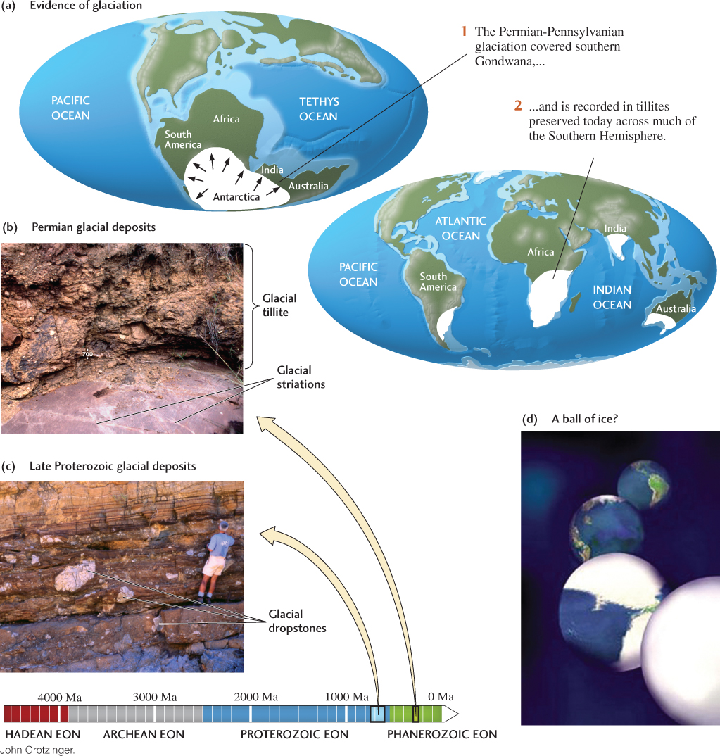
The oldest confirmed glaciation occurred during the Proterozoic eon, about 2.4 billion years ago. Its glacial deposits are preserved in Wyoming, along the Canadian portion of the Great Lakes, in northern Europe, and in South Africa. Some geologists argue for an even older glaciation in the Archean eon, almost 3 billion years ago, but that interpretation is disputed.
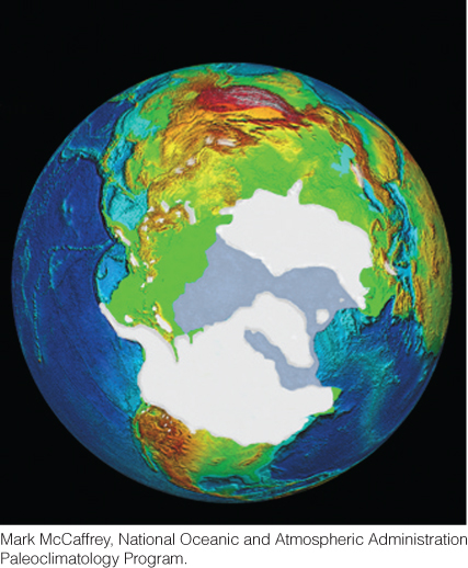
The youngest Proterozoic glaciation, which spanned a period between 750 million and about 600 million years ago, involved several ice ages separated by warm interglacial periods. Glacial deposits of this age have been found on every continent (Figure 21.25c). Curiously, the reconstruction of paleocontinents indicated that the ice sheets in the Northern Hemisphere had extended much farther south than during the Pleistocene glaciations, perhaps all the way to the equator! This evidence has provoked some geologists to speculate that Earth may have been completely covered by ice, from pole to pole—a bold hypothesis called Snowball Earth (Figure 21.25d).
According to the Snowball Earth hypothesis, there was ice everywhere—even the oceans were frozen. The average global temperature would have been about 240°C, like that of the Antarctic today. Except for a few warm spots near volcanoes, very little life would have survived. How could such an apocalyptic event have occurred? And how could it have ended, returning us to the climate we know today? The answers may lie in the feedbacks that occur within the climate system (described in Chapter 15).
610
According to one scenario, as Earth initially cooled, ice sheets at the poles spread outward, their white surfaces reflecting more and more sunlight away from Earth. The increase in Earth’s albedo cooled the planet, which further expanded the ice sheets. This self-reinforcing process continued until it reached the tropics, encasing the planet in a layer of ice as much as 1 km thick. This scenario is an example of albedo feedback gone wild.
Earth remained buried in ice for millions of years, but the few volcanoes that poked above the surface slowly pumped carbon dioxide into the atmosphere. When the concentration of carbon dioxide reached a critical level, temperatures rose, the ice melted, and Earth again became a greenhouse.
611
The Snowball Earth hypothesis is very controversial, and many geologists disagree with the idea that the oceans were completely frozen. Nevertheless, the evidence for glaciation at low latitudes is strong, and the hypothesis serves as an example of the potential of feedbacks in Earth’s climate system to produce extreme change. Geologists have their work cut out for them in trying to understand the extremes of Earth’s climate system.