The Plates and Their Boundaries
According to the theory of plate tectonics, the lithosphere is not a continuous shell, but is broken into a mosaic of rigid plates that move over Earth’s surface (Figure 2.7). Each plate travels as a distinct unit, riding on the asthenosphere, which is also in motion. The largest is the Pacific Plate, which comprises much (though not all) of the Pacific Ocean basin. Some of the plates are named after the continents they include, but in no case is a plate identical with a continent. The North American Plate, for instance, extends from the Pacific coast of North America to the middle of the Atlantic Ocean, where it meets the Eurasian and African plates.
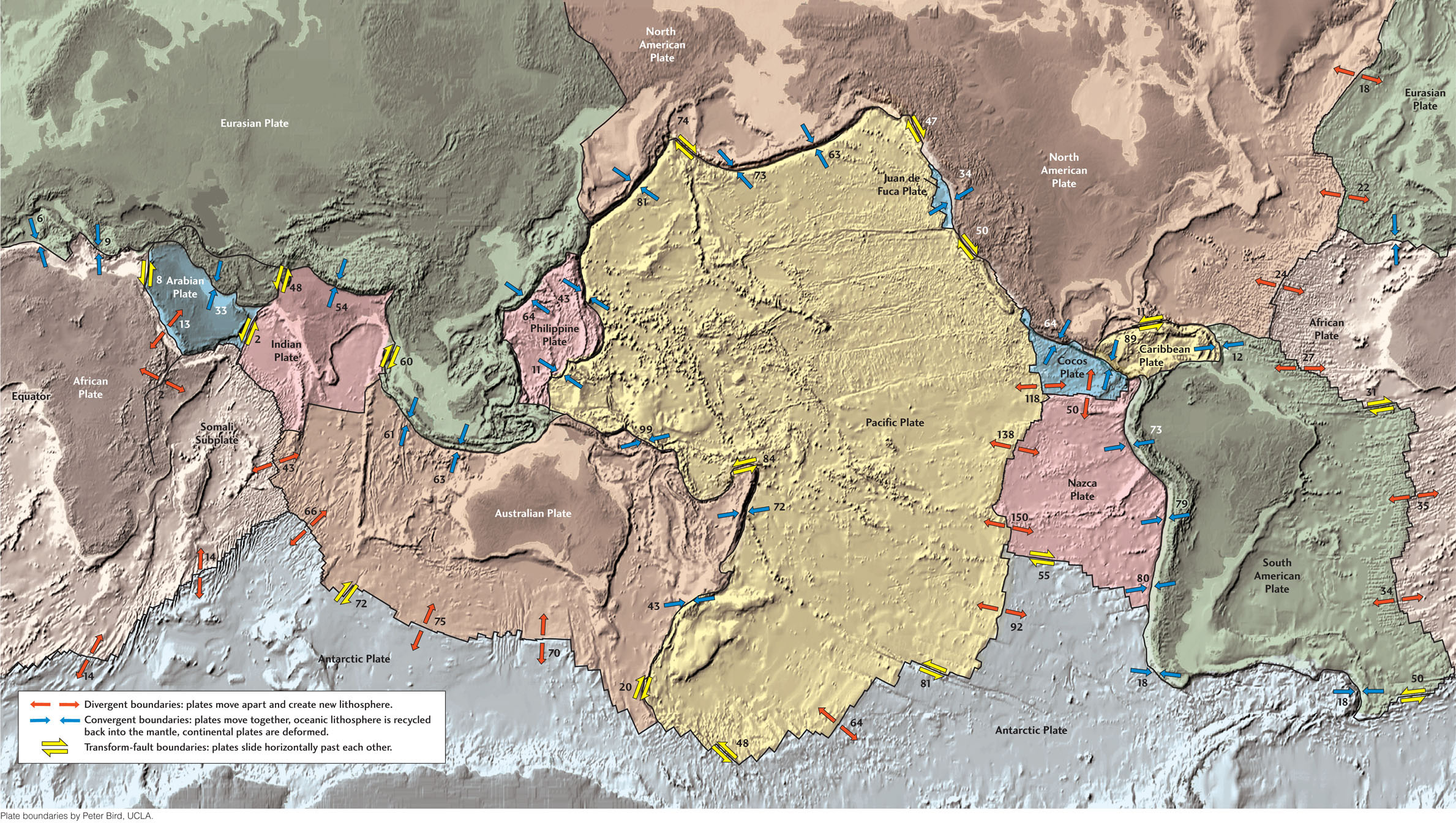
In addition to the 13 major plates, there are a number of smaller ones. An example is the Juan de Fuca Plate, a small piece of oceanic lithosphere trapped between the giant Pacific and North American plates just offshore of the northwestern United States. Others are continental fragments, such as the small Anatolian Plate, which includes much of Turkey.
To see plate tectonics in action, go to a plate boundary. Depending on which boundary you visit, you may find earthquakes, volcanoes, rising mountains, long, narrow rifts, folding, or faulting. Many geologic features develop through the interactions of plates at their boundaries.
There are three basic types of plate boundaries (Figure 2.8), all defined by the direction of movement of the plates relative to each other:
 At divergent boundaries, plates move apart and new lithosphere is created (plate area increases).
-
At convergent boundaries, plates come together and one plate is recycled into the mantle (plate area decreases).
-
At transform faults, plates slide horizontally past each other (plate area does not change).
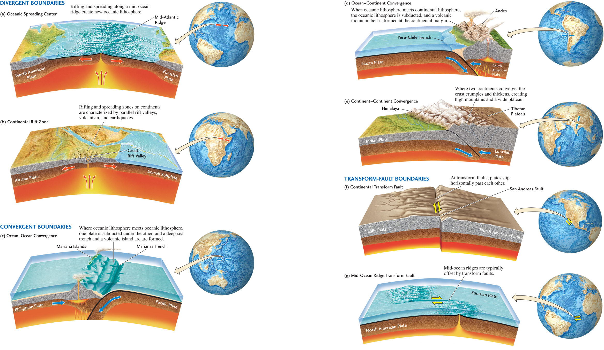
Like many models of nature, these three plate boundary types are idealized. There are also “oblique” boundaries that combine divergence or convergence with some amount of transform faulting. Moreover, what actually goes on at a plate boundary depends on the type of lithosphere involved, because continental and oceanic lithosphere behave differently. The continental crust is made of rocks that are both lighter and weaker than those of either the oceanic crust or the mantle beneath the crust (see Figure 1.11). Later chapters will examine these differences in more detail; for now, you need to keep in mind only two of their consequences:
32
33
34
35
36
- 1. Because continental crust is lighter, it is not as easily recycled back into the mantle as oceanic crust.
- 2. Because continental crust is weaker, plate boundaries that involve continental crust tend to be more spread out and more complicated than those that involve oceanic crust.
Divergent Boundaries
Divergent boundaries are where the plates move apart. Divergent boundaries within ocean basins are narrow rifts that approximate the idealization of plate tectonics. Divergent boundaries within continents are usually more complicated and distributed over a wider area. This difference is illustrated in Figures 2.8a and 2.8b.
Oceanic Spreading Centers
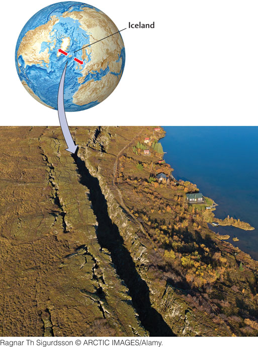
On the seafloor, the boundary between separating plates is marked by a mid-ocean ridge, an undersea mountain chain that exhibits earthquakes, volcanism, and rifting, all caused by the tensional (stretching) forces of mantle convection that are pulling the two plates apart. As the seafloor spreads, hot molten rock, called magma, wells up into the rifts to form new oceanic crust. Figure 2.8a shows what happens at one such spreading center on the Mid-Atlantic Ridge, where the North American and Eurasian plates are separating. (A more detailed map of the Mid-Atlantic Ridge is shown in Figure 2.4.) The island of Iceland exposes a segment of the otherwise submerged Mid-Atlantic Ridge, allowing geologists to view the processes of plate separation and seafloor spreading directly (Figure 2.9). The Mid-Atlantic Ridge continues in the Arctic Ocean north of Iceland and, to the south, it connects to a nearly globe-encircling system of mid-ocean ridges that wind through the Indian and Pacific oceans, ending along the west coast of North America. Seafloor spreading at these mid-ocean ridges has created the millions of square kilometers of oceanic crust that now form the floors of the world’s oceans.
Continental Rifting
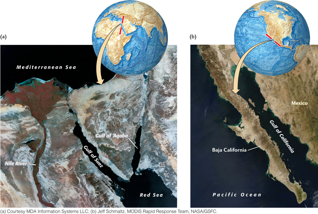
Early stages of plate separation, such as the divergence that forms the Great Rift Valley of east Africa (see Figure 2.8b), can be found on some continents. These divergent boundaries are characterized by rift valleys, volcanism, and earthquakes distributed over a wider zone than is found at oceanic spreading centers. The Red Sea and the Gulf of California are rifts that are further along in the spreading process (Figure 2.10). In these cases, the continents have separated enough for new oceanic crust to form along the spreading axis, creating a deep basin into which the ocean has flooded.
Sometimes continental rifting slows or stops before the continent actually splits apart. The Rhine Valley, along the border of Germany and France in western Europe, is a weakly active continental rift that may be this type of “failed” spreading center. Will the East African Rift continue to open, causing the Somali Subplate to split away from Africa completely and form a new ocean basin, as happened between Africa and the island of Madagascar? Or will the spreading slow and eventually stop, as appears to be happening in western Europe? Geologists don’t know the answer.
Convergent Boundaries
Lithospheric plates cover the globe, so if they separate in one place, they must converge somewhere else, if Earth’s surface area is to remain the same. (As far as we can tell, our planet is not expanding!) Where plates come together, they form convergent boundaries. The geologic processes that act during plate convergence make these boundaries more complex than the other boundary types.
Ocean-Ocean Convergence
If the lithosphere of both converging plates is oceanic, one plate descends beneath the other in a process known as subduction (see Figure 2.8c). The lithosphere of the subducting plate sinks into the asthenosphere and is eventually recycled by the mantle convection system. This sinking produces a long, narrow deep-sea trench. In the Marianas Trench of the western Pacific, the ocean reaches its greatest depth, about 11 km—deeper than the height of Mount Everest.
37
As the cold slab of lithosphere descends deeper into Earth’s interior, the pressure on it increases. Water trapped in the rocks is squeezed out and rises into the asthenosphere above the slab. This fluid causes the mantle material above it to melt. The resulting magma produces a chain of volcanoes, called an island arc, behind the trench. The subduction of the Pacific Plate has formed the volcanically active Aleutian Islands west of Alaska as well as the Mariana Islands and other island arcs in the western Pacific. The lithospheric slabs descending into the mantle cause earthquakes as deep as 690 km beneath some island arcs.
Ocean-Continent Convergence
If one plate has a continental edge, it overrides the oceanic lithosphere of the other plate because continental lithosphere is less dense and therefore less easily subducted (see Figure 2.8d). The submerged margin of the continent is crumpled by the convergence, deforming the continental crust and uplifting rocks into a mountain belt roughly parallel to the deep-sea trench. The enormous compressive (squeezing) forces of convergence and subduction produce great earthquakes along the subduction zone. Over time, materials are scraped off the descending slab and incorporated into the adjacent mountain belt, leaving geologists with a complex (and often confusing) record of the subduction process. As in the case of ocean-ocean convergence, the water carried downward by the subducting oceanic lithosphere causes mantle material to melt; the resulting magma rises and forms volcanoes in the mountain belt behind the trench.
The west coast of South America, where the South American Plate converges with the Nazca Plate, is a subduction zone of this type. A great chain of high mountains, the Andes, rises on the continental side of this convergent boundary, and a deep-sea trench lies just off the coast. The volcanoes here are active and deadly. One of them, Nevado del Ruiz in Colombia, killed 25,000 people when it erupted in 1985. Some of the world’s largest earthquakes have been recorded along this boundary.
38
Another example is the Cascadia subduction zone, where the small Juan de Fuca Plate converges with the North American Plate off the coast of western North America. This convergent boundary gives rise to the dangerous volcanoes of the Cascade Range, such as Mount St. Helens, which had a major eruption in 1980 and a minor one in 2004. There is increasing worry that a great earthquake will occur in the Cascadia subduction zone and cause devastating damage along the coasts of Oregon, Washington, and British Columbia. Such an earthquake could cause a disastrous tsunami as large as the one generated by the great Tohoku earthquake of March 11, 2011, which occurred in a subduction zone off the northeastern coast of Honshu, Japan.
Continent-Continent Convergence
Where two continents converge (see Figure 2.8e), the kind of subduction seen at other convergent boundaries cannot occur. The geologic consequences of such a continent-continent collision are impressive. The collision of the Indian and Eurasian plates, both with continents at their leading edges, provides the best example. The Eurasian Plate overrides the Indian Plate, but India and Asia remain afloat on the mantle. The collision creates a double thickness of crust, forming the highest mountain range in the world, the Himalaya, as well as the vast high Tibetan Plateau. Severe earthquakes occur in the crumpling crust of this and other continent-continent collision zones.
Many episodes of mountain building throughout Earth’s history were caused by continent-continent collisions. The Appalachian Mountains, which run along the east coast of North America, were uplifted when North America, Eurasia, and Africa collided to form the supercontinent Pangaea about 300 million years ago.
Transform Faults
At boundaries where plates slide past each other, lithosphere is neither created nor destroyed. Such boundaries are transform faults: fractures along which the plates slip horizontally past each other (see Figure 2.8f, g).
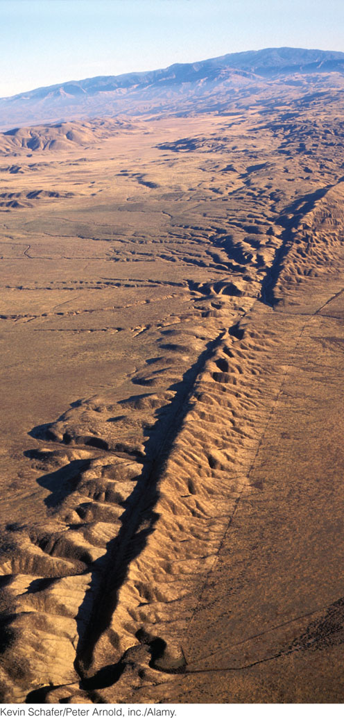
The San Andreas fault in California, where the Pacific Plate slides past the North American Plate, is a prime example of a continental transform fault (see Figure 2.8f). Because the plates have been sliding past each other for millions of years, the rocks facing each other on the two sides of the fault are of different types and ages (Figure 2.11). Large earthquakes, such as the one that destroyed San Francisco in 1906, can occur on transform faults. There is much concern that, within the next several decades, a sudden rupture of the San Andreas fault, or on related faults near Los Angeles and San Francisco, will result in an extremely destructive earthquake.
Transform-fault boundaries are typically found along mid-ocean ridges where the continuity of a spreading zone is broken and the boundary is offset in a steplike pattern. An example can be found along the boundary between the African Plate and the South American Plate in the central Atlantic Ocean (see Figure 2.8g). Transform faults can also connect divergent plate boundaries with convergent plate boundaries and convergent boundaries with other convergent boundaries. Can you find examples of these types of transform-fault boundaries in Figure 2.7?
Combinations of Plate Boundaries
Each plate is bordered by some combination of divergent, convergent, and transform-fault boundaries. For example, the Nazca Plate is bounded on three sides by spreading centers, offset in a steplike pattern by transform faults, and on one side by the Peru-Chile subduction zone (see Figure 2.7). The North American Plate is bounded on the east by the Mid-Atlantic Ridge, a spreading center, and on the west by subduction zones and transform-fault boundaries.
39