Rates and History of Plate Movements
How fast do plates move? Do some plates move faster than others, and if so, why? Is the velocity of plate movements today the same as it was in the geologic past? Geologists have developed ingenious methods to answer these questions and thereby to gain a better understanding of plate tectonics. In this section, we will examine three of these methods.
The Seafloor as a Magnetic Tape Recorder
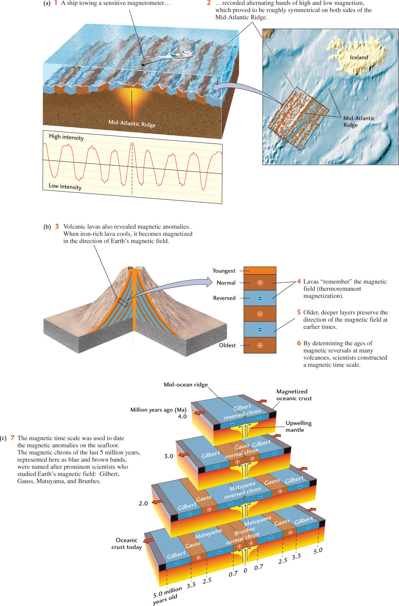
During World War II, extremely sensitive magnetometers were developed to detect submarines by the magnetic fields emanating from their steel hulls. Geologists modified these instruments slightly and towed them behind research ships to measure the local magnetic field created by magnetized rocks on the seafloor. Steaming back and forth across the ocean, seagoing scientists discovered regular patterns in the strength of the local magnetic field that completely surprised them. In many areas, the intensity of the magnetic field alternated between high and low values in long, narrow parallel bands, called magnetic anomalies, that were almost perfectly symmetrical with respect to the crest of a mid-ocean ridge (Figure 2.12). The detection of these patterns was one of the great discoveries that confirmed the seafloor spreading hypothesis and led to the theory of plate tectonics. It also allowed geologists to trace plate movements far back in geologic time. To understand these advances, we need to look more closely at how rocks become magnetized.
The Rock Record of Magnetic Reversals on Land
Magnetic anomalies are evidence that Earth’s magnetic field does not remain constant over time. At present, the north magnetic pole is closely aligned with the geographic north pole (see Figure 1.17), but small changes in the geodynamo can flip the orientation of the north and south magnetic poles by 1808, causing a magnetic reversal.
In the early 1960s, geologists discovered that a precise record of this peculiar behavior can be obtained from layered flows of volcanic lava. When iron-rich lavas cool, they become slightly but permanently magnetized in the direction of Earth’s magnetic field. This phenomenon is called thermoremanent magnetization because the cold lava “remembers” the magnetization long after the magnetic field has changed.
In layered lava flows, such as those in a volcanic cone, the rocks at the top represent the most recent layer, while layers deeper in the cone are older. The age of each layer can be determined by various dating methods (described in Chapter 8). The direction of magnetization of rock samples from each layer then reveals the direction of Earth’s magnetic field at the time when that layer cooled (Figure 2.12b). By repeating these measurements at hundreds of places around the world, geologists have worked out the magnetic time scale of the past 200 million years. Figure 2.12c shows this time scale for the most recent 5 million years. About half of all volcanic rocks studied have been found to be magnetized in a direction opposite to that of Earth’s present magnetic field. Apparently, the field has flipped frequently over geologic time, so normal fields (same as now) and reversed fields (opposite to now) are equally likely. Major periods during which the field is normal or reversed are called magnetic chrons (from the Greek for “time”); they last about half a million years, on average, although the pattern of reversals becomes highly irregular as we move back in geologic time. Within the major chrons are short-lived reversals of the field, known as magnetic subchrons, which may last anywhere from several thousand to 200,000 years.
Magnetic Anomaly Patterns On the Seafloor
The banded patterns of magnetism found on the seafloor puzzled scientists until 1963, when two Englishmen, F. J. Vine and D. H. Mathews—and, independently, two Canadians, L. Morley and A. Larochelle—made a startling proposal. Based on evidence of magnetic reversals that geologists had collected from lava flows on land, they reasoned that the bands of high and low magnetic intensity on the seafloor corresponded to bands of rock that were magnetized during ancient episodes of normal and reversed magnetism. That is, when a research ship was above rocks magnetized in the normal direction, it would record a locally stronger field, or a positive magnetic anomaly. When it was above rocks magnetized in the reversed direction, it would record a locally weaker field, or a negative magnetic anomaly.
The seafloor spreading hypothesis explained these observations: when the plates move apart at a mid-ocean ridge, magma rises from Earth’s interior and flows into the rift, where it cools, solidifies, and becomes magnetized in the direction of Earth’s magnetic field at the time. As the seafloor spreads away from the ridge, approximately half of the newly magnetized material moves to one side and half to the other, forming two symmetrical magnetized bands. Newer material fills the rift, continuing the process. In this way, the seafloor acts like a magnetic tape recorder that encodes the history of the opening of the oceans.
40
41
Inferring Seafloor Ages and Relative Plate Velocity
By using the ages of magnetic reversals that had been worked out from magnetized lavas on land, geologists were able to assign ages to the bands of magnetized rocks on the seafloor. They could then calculate how fast the seafloor was spreading by using the formula speed = distance ÷ time, where distance is measured from the mid-ocean ridge axis and time equals seafloor age. For instance, the magnetic anomaly pattern in Figure 2.12c shows that the boundary between the Gauss normal chron and the Gilbert reversed chron, which was dated from lava flows at 3.3 million years of age, is located about 30 km away from the crest of the Mid-Atlantic Ridge just southwest of Iceland. Thus, seafloor spreading has moved the North American and Eurasian plates apart by about 60 km in 3.3 million years, giving a spreading rate of 18 km per million years or, equivalently, 18 mm/year. On a divergent plate boundary, the combination of the spreading rate and the spreading direction gives the relative plate velocity, the velocity at which one plate moves relative to the other.
The speed record for spreading can be found on the East Pacific Rise just south of the equator, where the Pacific and Nazca plates are separating at a rate of about 150 mm/year—much faster than the rate in the North Atlantic. A rough average spreading rate for mid-ocean ridges around the world is 50 mm/year. This is approximately the rate at which your fingernails grow—so, geologically speaking, the plates move very fast indeed!
Mapping magnetic anomalies on the seafloor has been an amazingly effective and very expedient method for working out the history of ocean basins. Simply by steaming a ship back and forth over the ocean surface, measuring the magnetic fields of the seafloor rocks, and correlating the pattern of magnetic anomalies with the magnetic time scale, geologists have been able to determine the ages of various regions of the seafloor by remote sensing—that is, without directly sampling the oceanic crust far below the surface. In effect, they have learned how to “replay the tape.”
Deep-Sea Drilling
In 1968, a seafloor drilling program was launched as a joint project of several major U.S. oceanographic institutions and the National Science Foundation. Later, many nations joined the effort (Figure 2.13). Using hollow drills, scientists brought up cores containing sections of seafloor rock from many locations in the oceans.
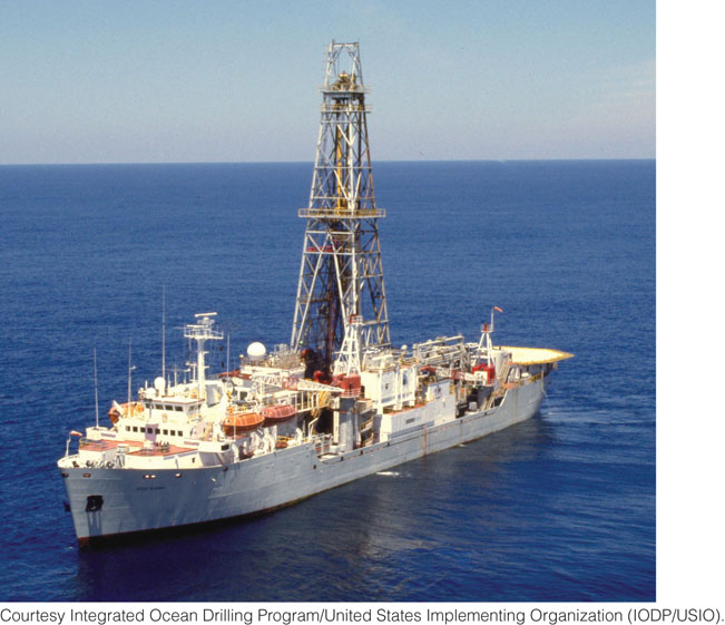
Small particles falling through the ocean waters—dust from the atmosphere, organic material from marine plants and animals—begin to accumulate as seafloor sediments on new oceanic crust as soon as it forms. Therefore, the age of the oldest sediments in a core—those immediately on top of the crust—tells the geologist how old the crust is at that spot. The ages of sediments can be calculated from the fossil skeletons of tiny single-celled planktonic organisms that live at the surface of the open ocean and sink to the bottom when they die. Geologists found that the ages of the samples in the drill cores increased with distance from mid-ocean ridges, and that the age of the samples at any one place agreed almost perfectly with the age of the seafloor determined from magnetic reversal data. This agreement validated the magnetic time scale and provided strong evidence for seafloor spreading.
Measurements of Plate Movements by Geodesy
Astronomical Positioning
Astronomical positioning—measuring the positions of points on Earth’s surface in relation to the fixed stars in the night sky—is a technique of geodesy, the ancient science of measuring the shape of Earth and locating points on its surface. Surveyors have used astronomical positioning for centuries to determine geographic boundaries on land, and sailors have used it to locate their ships at sea. Four thousand years ago, Egyptian builders used astronomical positioning to aim the Great Pyramid due north.
42
Because of the high accuracy that would have been required to observe plate movements directly, geodetic techniques did not play a significant role in the discovery of plate tectonics. Geologists had to rely on evidence of seafloor spreading from the geologic record—the magnetic anomalies and ages of fossils described earlier. Beginning in the late 1970s, however, an astronomical positioning method was developed that used signals from distant “quasi-stellar radio sources” (quasars) recorded by huge radio telescopes. This method can measure intercontinental distances to an amazing accuracy of 1 mm. In 1986, a team of scientists using this method showed that the distance between radio telescopes in Europe (Sweden) and North America (Massachusetts) had increased 19 mm/year over a period of 5 years, very close to the rate predicted by geologic models of plate tectonics.
Today, the Great Pyramid of Egypt is not aimed directly north, but slightly east of north. Did the ancient Egyptian astronomers make a mistake in orienting the pyramid 40 centuries ago? Archaeologists think not. Over this period, Africa drifted enough to rotate the pyramid out of alignment with true north.
The Global Positioning System
Doing geodesy with big radio telescopes is expensive and is not a practical means of investigating plate movements in remote areas of the world where no radio telescopes exist. Since the mid-1980s, geologists have used a constellation of 24 Earth-orbiting satellites, called the Global Positioning System (GPS), to make the same types of measurements with the same astounding accuracy. The satellite constellation serves as an outside frame of reference, just as the fixed stars and quasars do in astronomical positioning. The satellites emit high-frequency radio waves keyed to precise atomic clocks on board. Those signals can be picked up by inexpensive, portable radio receivers not much bigger than this textbook (Figure 2.14). These devices are similar to the GPS receivers used in automobiles and by hikers, though much more precise.
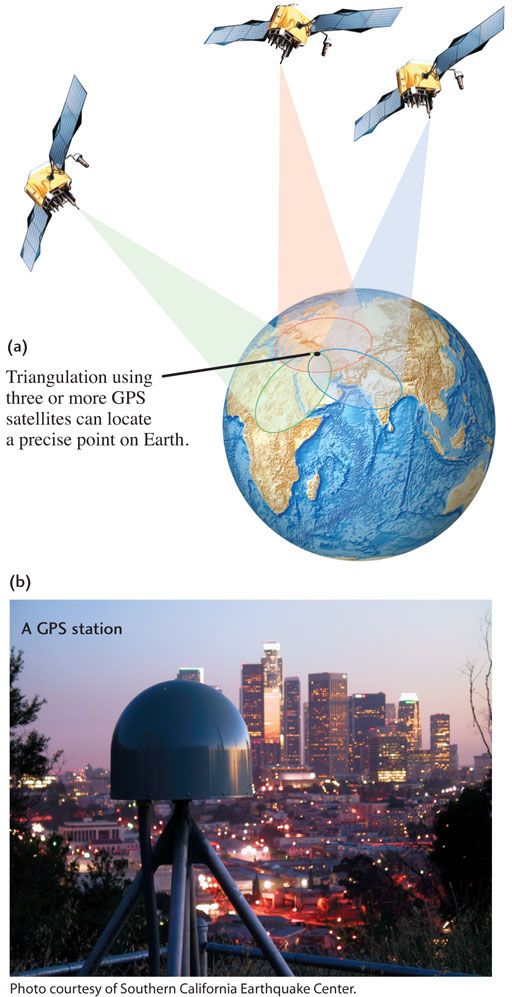
Geologists use GPS to measure plate movements on a regular basis at many locations around the globe. Changes in distance between land-based GPS receivers placed on different plates, recorded over several years, agree in both magnitude and direction with those calculated from magnetic anomalies on the seafloor, indicating that plate movements are remarkably steady over periods ranging from just a few years to millions of years, as demonstrated in the Practicing Geology Exercise at the end of this chapter.