Sedimentary Basins: The Sinks for Sediments
As we have seen, the currents that move sediments across Earth’s surface generally flow downhill. Therefore, sediments tend to accumulate in depressions in Earth’s crust. Such depressions are formed by subsidence, in which a broad area of the crust sinks (subsides) relative to the surrounding crust. Subsidence is induced partly by the weight of sediments on the crust, but is caused mainly by plate tectonic processes.
Sedimentary basins are regions of variable size where the combination of sedimentation and subsidence has formed thick accumulations of sediments and sedimentary rocks. Sedimentary basins are Earth’s primary sources of oil and natural gas. Commercial exploration for these resources has helped us better understand the deep structure of sedimentary basins and of the continental lithosphere.
Rift Basins and Thermal Subsidence Basins
When plate separation begins within a continent, subsidence results from the stretching, thinning, and heating of the underlying lithosphere by the plate tectonic processes that are causing the separation (Figure 5.8). A long, narrow rift develops, bounded by great downdropped blocks of crustal rock. Hot, ductile mantle material rises, melts, and fills the space created by the thinned lithosphere and crust, initiating the eruption of basaltic lavas in the rift zone. Such rift basins are deep, narrow, and long, with thick successions of sedimentary rocks and extrusive and intrusive igneous rocks. The rift valleys of East Africa, the Rio Grande Valley, and the Jordan Valley in the Middle East are examples of rift basins.
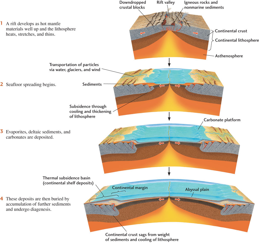
At later stages of plate separation, when rifting has led to seafloor spreading and the newly separated continents are drifting away from each other, subsidence continues through the cooling of the lithosphere that was thinned and heated during the earlier rifting stage (see Figure 5.8). Cooling leads to an increase in the density of the lithosphere, which in turn leads to its subsidence below sea level, where sediments can accumulate. Because cooling of the lithosphere is the main process creating the sedimentary basins at this stage, they are called thermal subsidence basins. Sediments from erosion of the adjacent land fill the basin nearly to sea level along the edge of the continent, creating a continental shelf.
The continental shelf continues to receive sediments for a long time because the trailing edge of the drifting continent subsides slowly and because the continent provides a tremendous land area from which sediments can be derived. The load of the growing mass of sediment further depresses the crust, so that the basin can receive still more material from the land. As a result of this continuous subsidence and sediment transportation, continental shelf deposits can accumulate in an orderly fashion to thicknesses of 10 km or more. The continental shelves off the Atlantic coasts of North and South America, Europe, and Africa are good examples of thermal subsidence basins. These basins began to form when the supercontinent Pangaea split apart about 200 million years ago and the North American and South American plates separated from the Eurasian and African plates.
123
Flexural Basins
A third type of sedimentary basin develops at convergent plate boundaries where one plate pushes up over the other. The weight of the overriding plate causes the underlying plate to bend or flex down, producing a flexural basin. The Mesopotamian Basin in Iraq is a flexural basin formed when the Arabian Plate collided with and was subducted beneath the Eurasian Plate. The enormous oil reserves in Iraq (second only to Saudi Arabia’s) owe their size to having the right ingredients in this important flexural basin. In effect, oil that had formed in the rocks now beneath the Zagros Mountains in Iran was squeezed out, forming several great pools of oil with volumes larger than 10 billion barrels.
124