Practicing Geology Exercise
How Do We Use Geologic Maps to Find Oil?
Crude oil, or petroleum (from the Latin words for “rock oil”), has been collected from natural seeps at Earth’s surface since ancient times. The foul-smelling, tarry substance was used as boat caulking, wheel grease, and medicine, but not commonly as a fuel until the process of oil refining was developed in the 1850s. Demand skyrocketed at that time, primarily because oil from whale blubber, the best fuel then available for lamps, had become terribly expensive (&60 per gallon in today’s dollars!) as overfishing decimated whale populations.
The ability to refine clean lamp oil from petroleum set off North America’s first oil boom. The mining of “black gold” was centered in areas around Lake Erie, where major petroleum seeps had been discovered—in northwestern Pennsylvania, northeastern Ohio, and southern Ontario. Early petroleum explorers, such as self-proclaimed “Colonel” Edwin Drake of Pennsylvania, simply drilled into the seeps, but this straightforward approach soon proved inadequate as a strategy for satisfying the new thirst for oil.
192
Could geologic knowledge be used to locate large petroleum reservoirs hidden underground—that is, in regions where no oil seeped to the surface? An affirmative answer was provided in 1861 by T. Sterry Hunt, a Connecticut-born geochemist. As a member of the Geological Survey of Canada, Hunt had been active in the new science of mapping natural resources. He documented the petroleum seeps of southern Ontario in 1850. As the oil production of the region increased, he noticed that seeps and successful wells tended to be aligned along the crests of geologic folds.
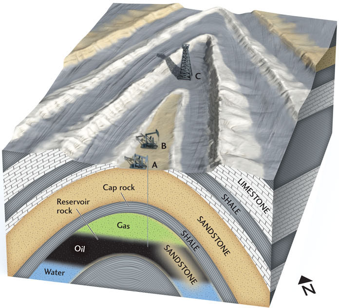
Hunt had also studied the physical and chemical properties of petroleum in the laboratory, and he knew it was formed when sedimentary rocks rich in organic material were subjected to heat and pressure (see Chapter 5). Petroleum is lighter than water; because of this buoyancy, it tends to rise toward the surface. Hunt hypothesized that the rising petroleum could accumulate in porous “reservoir rocks,” such as sandstones, if such rocks were overlain by impermeable “cap rocks,” such as shales, that prevented the petroleum from rising farther. Moreover, the most likely place to find large reservoirs would be along the fold axes of anticlines, where substantial amounts of petroleum could be trapped without escaping to the surface.
The accompanying figure illustrates a typical anticlinal trap, for which we can imagine the following narrative of geologic discovery. Erosion of the fold has exposed a sequence of sandstones, limestones, and shales. Mapping by an enterprising geologist shows that the axis of the anticline strikes to the northeast. Drilling at point A on the axis of the anticline first penetrates a thick sandstone layer exposed at the surface and then a thinner shale layer. Immediately below the shale the drilling crew encounters another sandstone layer containing gas and, below the gas, significant quantities of oil. The geologist infers that the shale is capping a major petroleum reservoir in the deeper sandstone layer, so he instructs his crew to move along the strike of the anticline and drill at point B. Bingo—another successful oil well!
Hunt’s “anticlinal theory” allowed geologists to discover oil (and some to get rich) by mapping fold structures at the surface and, later, by the three-dimensional imaging of such structures using seismic techniques. The results have been impressive: most of the one trillion barrels of crude oil produced since 1861 have come from anticlinal oil traps of the type that Hunt first described.
BONUS PROBLEM: The company that manages the petroleum claim in the figure would like to expand its operations, and they propose to drill a new well further along the axis of the anticline at point C. As a consulting geologist, how would you rate their chances of bringing in another successful well? Illustrate your answer by sketching a geologic cross section.
193