11-8 Rovers have found evidence of ancient Martian water
Parts of Mars are far drier than a bone, while others had standing water for extended periods
Just as ancient fossils on Earth provide evidence of how life has evolved on our planet, ancient rocks and geological formations help us understand how our planet’s surface and atmosphere have evolved. (For example, the oldest rocks on Earth have a chemical structure that shows the rocks formed during a time when there was little oxygen in the atmosphere and hence before the appearance of photosynthetic planet life.) Planetary scientists who want to learn about the history of Venus and Mars are therefore very interested in looking at ancient rocks on those worlds.
On Venus we cannot look very far into the past, since the planet’s volcanic activity and flake tectonics have erased features more than about 500 million years old (see Section 11-5). On Mars, by contrast, we expect to find rocks that are billions of years old: The thin atmosphere causes very little erosion, there has been little recent volcanic activity to cover ancient rocks, and there is no subduction to drag old surface features back into the planet’s interior. (The heavy cratering of the southern highlands bears testament to the great age of much of the Martian surface.) In a quest to find these ancient rocks and learn about the early history of Mars, scientists have sent spacecraft to land on the red planet and explore it at close range.
Landing on Mars
As of 2012, seven spacecraft have successfully landed on the Martian surface. Viking Lander 1 and Viking Lander 2, which we first discussed in Section 11-6, touched down in 1976. They had no capability to move around on the surface, and so each Viking Lander could only study objects within reach of the scoop at the end of its mechanical arm (Figure 11-33a). Figure 11-28 shows the view from the two Viking Lander sites.
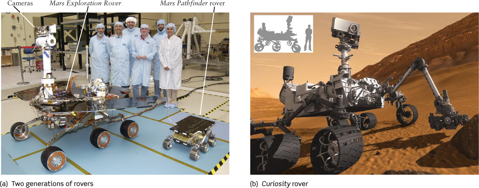
Martian Rovers (a) The technicians in this photograph pose with one of the Mars Exploration Rovers and with a replica of its predecessor, the Mars Pathfinder rover. (b) The rover Curiosity is much bigger than previous rovers; you can compare to the height of a person in parts (a) and (b). Curiosity will search for areas that may have been suitable for life.
Three more recent unmanned explorers, Mars Pathfinder (landed 1997) and two Mars Exploration Rovers named Spirit and Opportunity (landed 2004), were equipped with electrically driven wheels that allow travel over the surface. Unlike the Viking Landers, these rovers did not have a heavy and expensive rocket engine to lower them gently to the Martian surface. Instead, the spacecraft was surrounded by airbags like those used in automobiles. Had there been anyone to watch Mars Pathfinder or one of the Mars Exploration Rovers land, they would have seen an oversized beach ball hit the surface at 50 km/h (30 mi/h), then bounce for a kilometer before finally rolling to a stop. Unharmed by its wild ride, the spacecraft then deflated its airbags and began to study the geology of Mars. In 2008, the Phoenix Mars Lander sampled a challenging north polar region over a period of a few months; it did not rove around.
Figure 11-17 shows the landing sites of the Mars Pathfinder rover (named Sojourner) and the two Mars Exploration Rovers (Spirit and Opportunity). Following directions from Earth, Sojourner spent three months exploring the rocks around its landing site. The Mars Exploration Rovers were also designed for a three-month lifetime, and both remained operational years after landing. In fact, as of this writing, Opportunity has traveled more than 35 km over the Martian surface and continues to collect data. However, Spirit became stuck in soft sand in 2009 and communication was lost a year later. In addition to carrying cameras, most landers carried a device called an X-ray spectrometer to measure the chemical composition of rock samples. Spirit and Opportunity also carried a tool designed to grind holes into rocks, thus revealing parts of the rock’s interior that have not been weathered by exposure to the Martian atmosphere.
306
The most recent Mars landing was by the rover Curiosity (Figure 11-33b). The stunning landing, engineered by NASA’s Mars Science Laboratory mission, caught the public imagination in August 2012. Curiosity is too massive (900 kg) for the airbag landing scenario used to land earlier rovers. Instead, a parachute followed by rocket-thrusters provided the necessary speed reduction, but not all the way to the surface. To avoid stirring up too much dust onto the rover, a “sky crane” began lowering Curiosity down the last 20 meters. Curiosity is designed to analyze the habitability of Mars—the past or present conditions favorable for Martian microbial life. The rover is specially equipped to search for organic compounds thought to be necessary for life, as well as for chemical clues that life once existed. Curiosity is not equipped to study for life directly, and the promising ancient habitats it finds will need to be followed up by other missions in the search for life. As of early 2013, Curiosity was just beginning to analyze the surrounding terrain. For more about the Curiosity mission, see the Scientific American article at the end of this chapter.
The Martian Regolith
The Viking Landers were the first to reveal the nature of the Martian regolith, or surface material. The scoop on the extendable arm (Figure 11-33a) was used to dig into the regolith and retrieve samples for analysis. Bits of the regolith clung to a magnet mounted on the scoop, indicating that the regolith contains iron. The X-ray spectrometers showed that samples collected at both Viking Lander sites were rich in iron, silicon, and sulfur.
The Viking Landers each carried a miniature chemistry laboratory for analyzing the regolith. Curiously, when a small amount of water was added to a sample of regolith, the sample began to fizz and release oxygen. This experiment indicated that the regolith contains unstable chemicals called peroxides and superoxides, which break down in the presence of water to release oxygen gas.
The unstable chemistry of the Martian regolith probably comes from solar ultraviolet radiation that beats down on the planet’s surface. (Unlike Earth, Mars has no ozone layer to screen out ultraviolet light.) Ultraviolet photons easily break apart molecules of carbon dioxide (CO2) and water vapor (H2O) by knocking off oxygen atoms, which then become loosely attached to chemicals in the regolith.
Among the most important scientific goals of the Viking Landers was to search for evidence of life on Mars. Although it was clear that Mars has neither civilizations nor vast fields of plants, it still seemed possible that simple microorganisms could have evolved on Mars during its early brief epoch of Earthlike climate. If so, perhaps some species had survived to the present day. To test this idea, the Viking Landers looked for biologically significant chemical reactions in samples of the Martian regolith, but they failed to detect any reactions of this type. Perhaps life never existed on Mars, or perhaps it existed once but has since vanished. (In Chapter 27, we discuss the Viking Lander experiments in detail.)
307
Exploring Martian Rocks
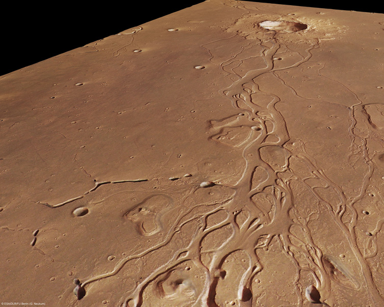
Images made from Mars orbit show a number of features that suggest water flowed there in the past (Figure 11-34). To investigate these, Mars Pathfinder landed in an area of the northern lowlands called Ares Valles, which appears to be an ancient flood plain. Figure 11-34b shows a portion of this plain. Flood waters can carry rocks of all kinds great distances from their original locations, so scientists expected that this landing site (Figure 11-35) would show great geologic diversity. They were not disappointed. Many of the rocks appeared to be igneous rock produced by volcanic action. Other rocks, which resemble the impact breccias found in the ancient highlands of the Moon (see Figure 10-18), appear to have come from areas that were struck by crater-forming meteoroids. Still others have a layered structure like sedimentary rocks on Earth (see Figure 9-18b). Such rocks form gradually at the bottom of bodies of water, suggesting that liquid water was stable in at least some regions of Mars for a substantial period of time.
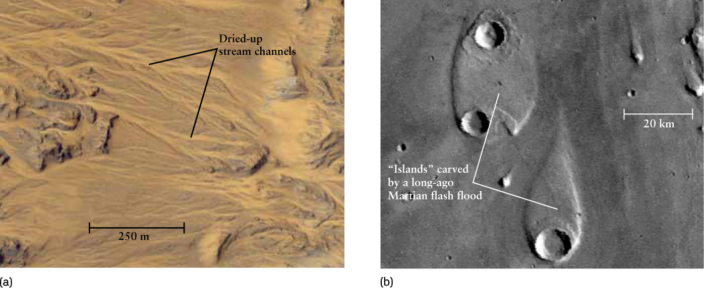
Sign of Ancient Martian Water (a) This Mars Reconnaissance Orbiter image shows patterns from flowing water almost identical to those caused by rainfall in deserts on Earth. No rain falls in today’s sparse Martian atmosphere, so these must date from an earlier era when the atmosphere was thicker. (b) These features rise above the floor of Ares Valles. They were carved out by a torrent of water that flowed from the bottom of the image toward the top. Similar flood-carved islands are found on Earth in eastern Washington State.
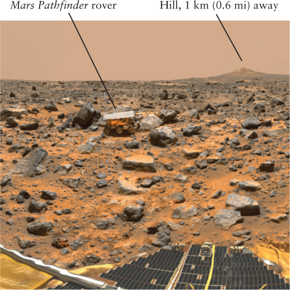
Roving the Martian Surface This view from the stationary part of Mars Pathfinder shows the rover, called Sojourner, deploying its X-ray spectrometer against a rock named Moe. Scientists gave other rocks whimsical names such as Jiminy Cricket and Pooh Bear.
Evidence for Ancient Martian Water

 In the search for life beyond Earth, the search for signs of ancient water on Mars has been one of NASA’s primary missions. If Mars ever supported life, biologists expect Martian life to have been dependent on water, just as it is for life on Earth. By finding where liquid water existed on Mars, rovers such as Curiosity can narrow the search further by looking for organic compounds, which are the building blocks of life (Chapter 27).
The two Mars Exploration Rovers landed in sites that were suspected to have been under water in the distant past. Spirit touched down in Gusev Crater, a large impact basin. A valley opens into this crater, resembling a river that runs into a lake. The destination for Opportunity was the flat plain of Sinus Meridianii, where orbiting spectrometers had spotted evidence of hematite—a type of iron oxide that, on Earth, tends to form in wet locations.
308
Contrary to expectations, most of the rocks encountered by Spirit show no evidence that they have been exposed to water. The volcanic rocks found in and around Gusev Crater (Figure 11-36a) are composed of the minerals olivine and pyroxene, which break down if they are exposed to liquid water. In a few locations Spirit found deposits of sulfur salts, which can be formed by the action of water (Figure 11-36b). However, olivine and pyroxene were still found among the sulfur salts. While it remains a possibility that Gusev Crater was once a river-fed lake, the results from Spirit show that for the past billion years this region has been drier than any desert on Earth.
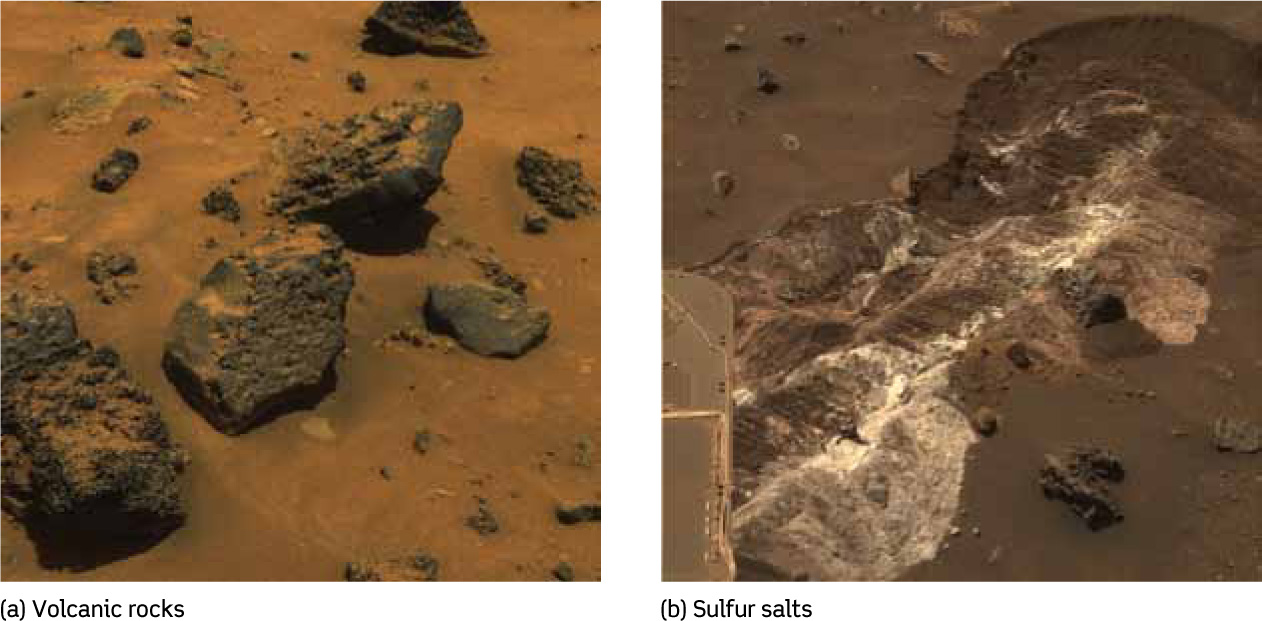
Dry Mars At the Spirit landing site, both (a) the dusty volcanic rocks that dominate the site and (b) these light-colored sulfur salts contain minerals that break apart upon contact with liquid water. Hence, this area must have been dry for billions of years.
The results from Opportunity were entirely different. This rover discovered outcrops of sedimentary rocks on the plains of Sinus Meridianii (Figure 11-37). On these plains, Opportunity found millimeter-sized spheres of hematite that, like analogous spheres found on Earth, probably formed from iron-rich water circulating through sediment. These observations suggest Sinus Meridianii, which is among the flattest places known in the solar system, was once a lake bed. It is not known how long ago this area was under water, but the density of craters found there suggests that the surface formed 3 to 4 billion years ago.
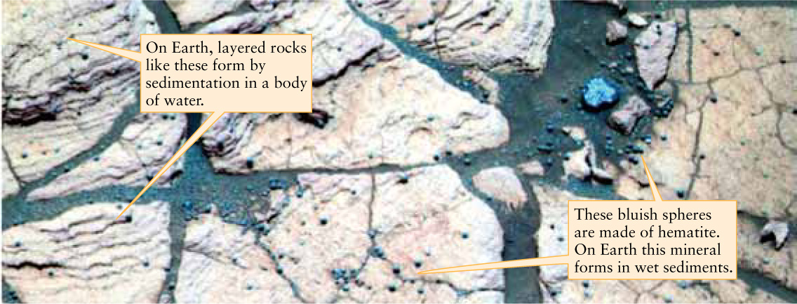
Wet Mars This false-color image shows two signatures of water found by Opportunity. Both the sedimentary rock (exposed by erosion) and the hematite spheres appearing blue require standing water to form. So, this area must have been under water for an extended period. The small spheres are typically a few millimeters in size and in these false-color images are often referred to as “blueberries.”
309
When combined with observations from Mars orbit, the Spirit and Opportunity results show that ancient Mars was a very diverse planet. Most of the planet was probably very dry, like Gusev Crater, but there were isolated areas like Sinus Meridianii that had liquid water for some period of time. It remains a challenge to planetary scientists to explain why liquid water appeared on Mars only in certain places and at certain times.
Where Is the Water Now?
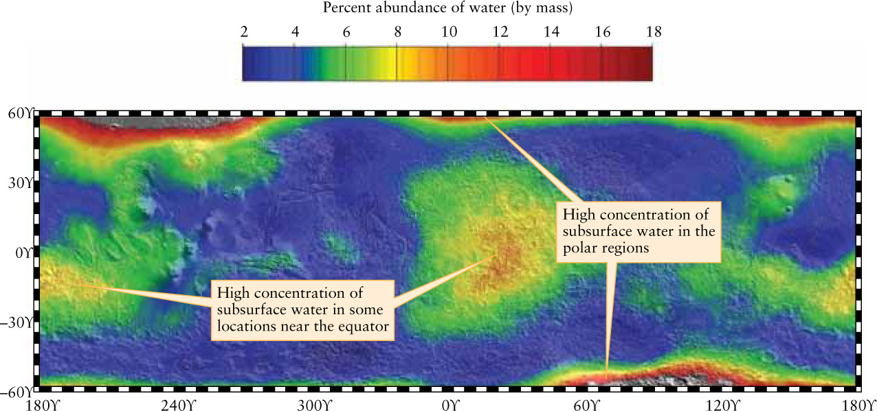
Whatever liquid water once coursed over parts of the Martian surface is presumably now frozen, either at the polar ice caps or beneath the planet’s surface. To check this idea, scientists used a device on board the Mars Odyssey orbiter to measure the result of cosmic rays hitting Mars.
Cosmic rays are fast-moving subatomic particles that enter our solar system from interstellar space. When these particles strike and penetrate into the Martian soil, they collide with the nuclei of atoms in the soil and knock out neutrons. (Recall from Section 5-7 that atomic nuclei contain both positively charged protons and electrically neutral neutrons.) If the ejected neutrons originate within a meter or so of the surface, they can penetrate through the regolith and escape into space. However, if there are water molecules (H2O) in the surface, the nuclei of the hydrogen atoms in these molecules tend to absorb the neutrons and prevent them from escaping. An instrument on board Mars Odyssey detects neutrons coming from Mars; where the instrument finds a deficiency of neutrons is where the soil contains hydrogen and, presumably, water.
The results from the Mars Odyssey neutron measurements show that there is abundant water beneath the surface at both Martian poles (Figure 11-38). But they also show a surprising amount of subsurface water in two regions near the equator, Arabia Terra (see Figure 11-13a and Figure 11-17) and another region on the opposite side of the planet. Recently, even small impacts have directly revealed ice just beneath the surface, but far away from the poles (Figure 11-39).
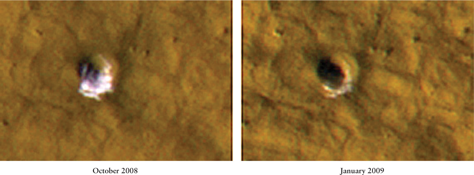
Water Revealed by Recent Impacts A fresh impact observed in 2008 revealed water-ice. The small crater is only 6 meters wide and shows that ice is just beneath the Martian surface about halfway between the north pole and the equator. A spectrum taken of the white material shows that it is water, and not carbon dioxide. By January 2009, several months later, the water had evaporated. Quite surprisingly, the white material is 99% pure water; a mixture with about 50% dirt was expected, and this remains a mystery.
One idea explaining water-ice near the equator is that about a million years ago, gravitational forces from other planets caused a temporary change in the tilt of Mars’s rotation axis. The ice caps were then exposed to more direct sunlight, causing some of the water to evaporate and eventually refreeze elsewhere on the planet. A big change in the tilt of Mars’s axis would not be surprising for two reasons. First, Earth’s large Moon stabilizes our rotation axis, but the Martian moons are too small to provide the planet with stabilizing forces. And second, Mars is close enough to Jupiter to be significantly influenced by Jupiter’s strong gravity.
There are other surprising features on Mars related to the presence of water. A number of Mars Global Surveyor images show gullies apparently carved by water flowing down the walls of pits or craters (Figure 11-40a). These gullies could have formed when water trapped underground—where the pressure is greater and water can remain a liquid—seeped onto the surface. The gullies appear to be geologically young, which suggests that even today some liquid water survives below the Martian surface. Alternatively, these gullies may have formed during periods when the Martian climate was colder than usual and the slopes of craters were covered with a layer of dust and snow. Melting snow on the underside of this layer could have carved out gullies, which were later exposed when the climate warmed and the snow evaporated. Very recently, deposits have also appeared on crater walls (Figure 11-40b)—indicating ongoing erosion—but it is not clear if water is involved. At least in the past, there’s evidence of liquid water resulting from a subsurface ice-melt. In Figure 11-41, flood channels emerge from a crater that would have been heated by the initial impact.
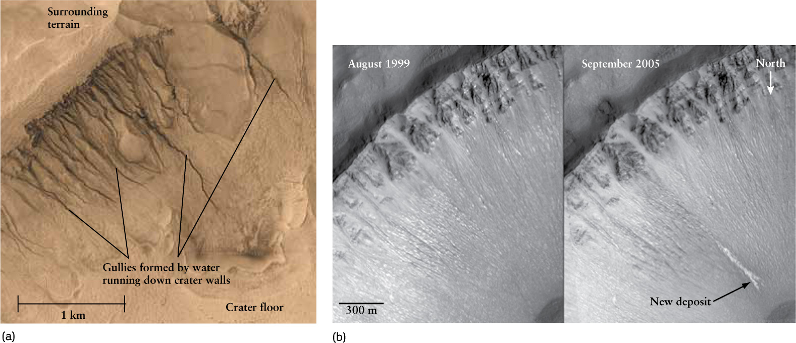
Martian Gullies (a) When the Mars Global Surveyor spacecraft looked straight down into this crater in the Martian southern hemisphere, it saw a series of gullies along the crater wall. These gullies may have formed by subsurface water seeping out to the surface, or by the melting of snow that fell on crater walls. (b) These two images of a southern hemisphere crater were taken six years apart. The new deposit seen in 2005 may have been caused by a subsurface melt, or might be a landslide unassociated with liquid water.
310
In 2012, Curiosity found strong evidence for the steady flow of water in an ancient stream or river, as opposed to a flash flood. Figure 11-42 shows rounded pebbles, just as we find in dry streambeds here on Earth. The pebbles are too big to have been moved by wind and indicate water-depths between ankle and knee high. Other nearby sites show similar rounding of pebbles, and based on images from orbit, the entire region has long been suspected as the outlet of an ancient river.
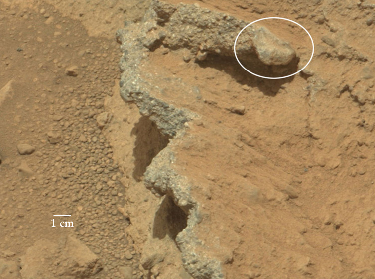
Dry Streambed The rounding of the pebbles at this site indicate they were exposed to flowing water for a period lasting at least thousands of years. The pebbles, and certainly the largest rock (in the white circle), could not have been rounded or transported by winds in the thin Martian atmosphere. The jagged overhanging rock ledge (running down the middle of the image) appears to be the bank of the stream, undercut by erosion from the stream itself. Even the rocky ledge appears to be made of a sedimentary rock from prior exposure to water.
Impact Melts Subsurface Ice The flood channels of Hephaestus Fossae run 600 km from a 20 km wide impact crater. Heat from the impact is thought to have caused frozen subsurface water-ice to melt.
311
Just how much water is thought to have once been in liquid form on Mars? By examining flood channels at various locations around Mars, Michael Carr of the U.S. Geological Survey has estimated that there was enough water to cover the planet to a depth of 500 m (1600 ft). (By comparison, Earth has enough water to cover our planet to a depth of 2700 m.) Thus, while the total amount of water on Mars is less than on Earth, there may have been enough to form lakes or seas. At least some of this water is now frozen under the Martian surface and at its poles.
CONCEPT CHECK 11-11
What are two different lines of evidence that point to present-day subsurface ice on Mars?