2-5 The seasons are caused by the tilt of Earth’s axis of rotation
Earth’s tilt causes variations in the concentration of sunlight
 In addition to rotating on its axis every 24 hours, Earth revolves around the Sun—that is, it orbits the Sun—in about 365¼ days (see Figure 2-5). As we travel with Earth around its orbit, we experience the annual cycle of seasons. But why are there seasons? Furthermore, the seasons are opposite in the northern and southern hemispheres. For example, February is midwinter in North America but midsummer in Australia. Why should this be?
29
The Origin of the Seasons
As we know from common experience, there are warmer temperatures in summer. This warmth is due to an increased amount of sunlight striking the ground beneath your feet and the surrounding areas. But what causes the concentration of sunlight to change through the seasons?
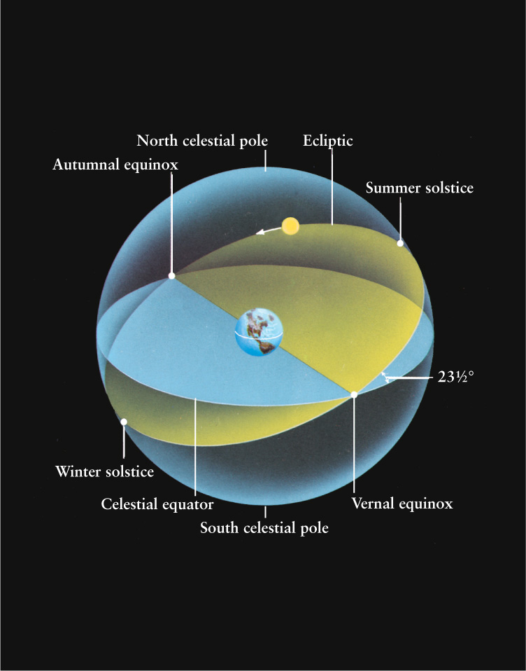
The reason why we have seasons, and why they are different in different hemispheres, is that Earth’s axis of rotation is not perpendicular to the plane of Earth’s orbit. Instead, as Figure 2-12 shows, the axis is tilted about 23½° away from the perpendicular. Earth maintains this tilt as it orbits the Sun, with Earth’s north pole always pointing in the same direction throughout the year. As we saw earlier, this direction just happens to have a star (named Polaris) within 1°. (This stability is a hallmark of all rotating objects. A top will not fall over as long as it is spinning, and the rotating wheels of a motorcycle help to keep the rider upright.)
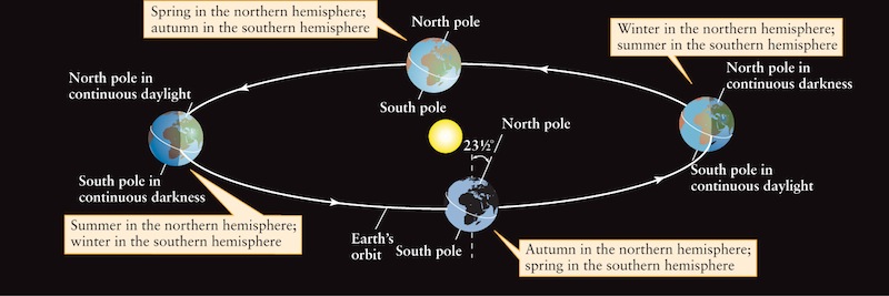
 The Seasons Earth’s axis of rotation is inclined 23½° away from the perpendicular to the plane of Earth’s orbit. The north pole points in the same direction as it orbits the Sun, near the star Polaris. Consequently, the amount of solar illumination and the number of daylight hours at any location on Earth vary in a regular pattern throughout the year. This is the origin of the seasons.
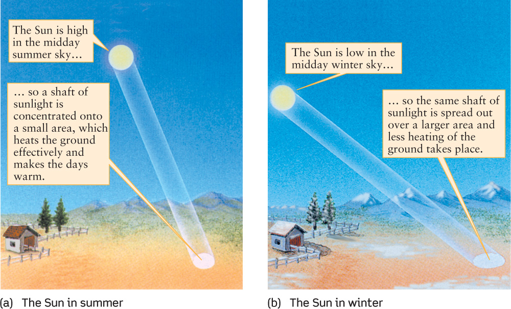
During part of the year, when Earth is in the part of its orbit shown on the left side of Figure 2-12, the northern hemisphere is tilted toward the Sun. As Earth spins on its axis, a point in the northern hemisphere spends more than 12 hours in the sunlight. Thus, the days there are long and the nights are short, and it is summer in the northern hemisphere. The summer is hot not only because of the extended daylight hours but also because the Sun is high in the northern hemisphere’s sky. As a result, sunlight strikes the ground at a nearly perpendicular angle that heats the ground efficiently (Figure 2-13a). During this same time of year in the southern hemisphere, the days are short and the nights are long, because a point in this hemisphere spends fewer than 12 hours a day in the sunlight. The Sun is low in the sky, so sunlight strikes the surface at a grazing angle that causes little heating (Figure 2-13b), and it is winter in the southern hemisphere.
30
TOOLS OF THE ASTRONOMER’S TRADE
Celestial Coordinates
Your latitude and longitude describe where on Earth’s surface you are located. The latitude of your location denotes how far north or south of the equator you are, and the longitude of your location denotes how far west or east you are of an imaginary circle that runs from the north pole to the south pole through the Royal Observatory in Greenwich, England. In an analogous way, astronomers use coordinates called declination and right ascension to describe the position of a planet, star, or galaxy on the celestial sphere.
Declination is analogous to latitude. As the illustration shows, the declination of an object is its angular distance north or south of the celestial equator, measured along a circle passing through both celestial poles. Like latitude, it is measured in degrees, arcminutes, and arcseconds (see Section 1-5).
Right ascension is analogous to longitude. It is measured from a line that runs between the north and south celestial poles and passes through a point on the celestial equator called the vernal equinox (shown as a red dot in the illustration). This point is one of two locations where the Sun crosses the celestial equator during its apparent annual motion, as we discuss in Section 2-5. In Earth’s northern hemisphere, spring officially begins when the Sun reaches the vernal equinox in late March. The right ascension of an object is the angular distance from the vernal equinox eastward along the celestial equator to the circle used in measuring its declination (see illustration). Astronomers measure right ascension in time units (hours, minutes, and seconds), corresponding to the time required for the celestial sphere to rotate through this angle. For example, suppose there is a star at your zenith right now with right ascension 6h 0m 0s. Two hours and 30 minutes from now, there will be a different object at your zenith with right ascension 8h 30m 0s.
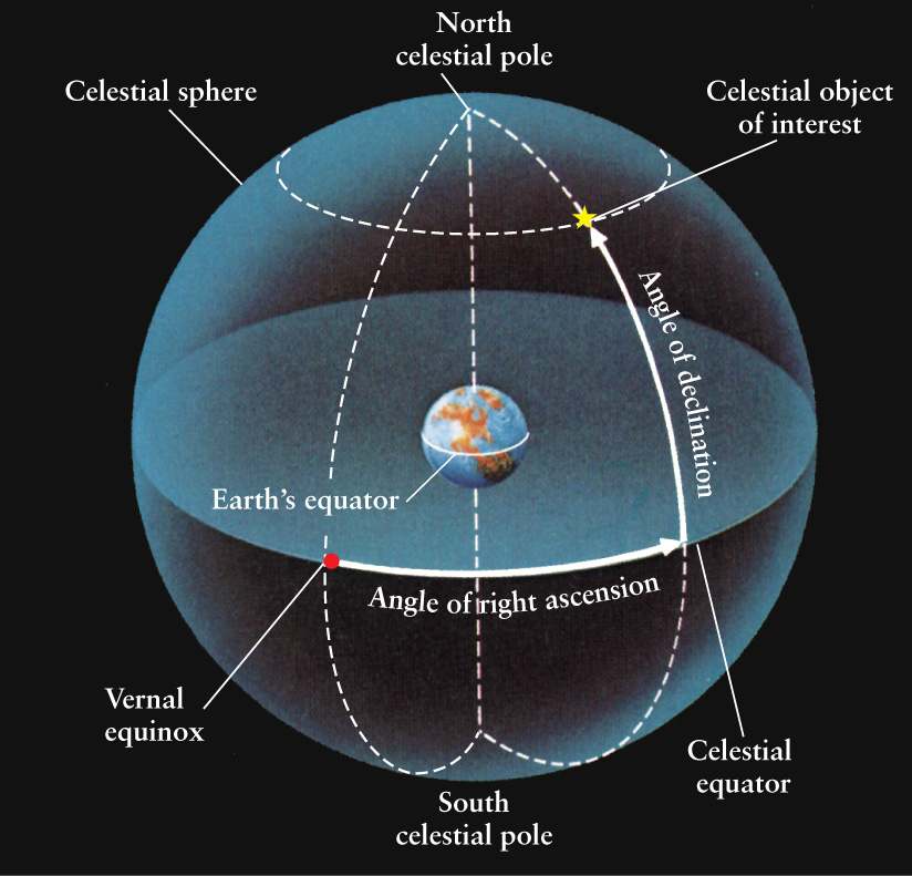
The coordinates of the bright star Rigel for the year 2000 are R.A. = 5h 14m 32.2s, Decl. = -8° 12' 06?. (R.A. and Decl. are abbreviations for right ascension and declination.) A minus sign on the declination indicates that the star is south of the celestial equator; a plus sign (or no sign at all) indicates that an object is north of the celestial equator. As we discuss in Box 2-2, right ascension helps determine the best time to observe a particular object.
It is important to state the year for which a star’s right ascension and declination are valid. This is so because of precession, which we discuss in Section 2-6.
EXAMPLE: What are the coordinates of a star that lies exactly halfway between the vernal equinox and the south celestial pole?
Situation: Our goal is to find the right ascension and declination of the star in question.
Tools: We use the definitions depicted in the figure.
Answer: Since the circle used to measure this star’s declination passes through the vernal equinox, this star’s right ascension is R.A. = 0h 0m 0s. The angle between the celestial equator and south celestial pole is 90° 0' 0?, so the declination of this star is Decl. = -45° 0' 0?.
Review: The declination in this example is negative because the star is in the southern half of the celestial sphere.
EXAMPLE: At midnight local time you see a star with R.A. = 2h 30m 0s at your zenith. When will you see a star at your zenith with R.A. = 21h 0m 0s?
Situation: If you held your finger stationary over a globe of Earth, the longitude of the point directly under your finger would change as you rotated the globe. In the same way, the right ascension of the point directly over your head (the zenith) changes as the celestial sphere rotates. We use this concept to determine the time in question.
Tools: We use the idea that a change in right ascension of 24h corresponds to an elapsed time of 24 hours and a complete rotation of the celestial sphere.
Answer: The time required for the sky to rotate through the angle between the stars is the difference in their right ascensions: 21h 0m 0s - 2h 30m 0s = 18h 30m 0s. So the second star will be at your zenith 18½ hours after the first one, or at 6:30 p.m. the following evening.
Review: Our answer was based on the idea that the celestial sphere makes exactly one complete rotation in 24 hours. If this were so, from one night to the next each star would be in exactly the same position at a given time. But because of the way that we measure time, the celestial sphere makes slightly more than one complete rotation in 24 hours. (We explore the reasons for this in Box 2-2.) As a result, our answer is in error by about 3 minutes. For our purposes, this is a small enough error that we can ignore it.
Half a year later, Earth is in the part of its orbit shown on the right side of Figure 2-12. Now the situation is reversed, with winter in the northern hemisphere (which is now tilted away from the Sun) and summer in the southern hemisphere. During spring and autumn, the two hemispheres receive roughly equal amounts of illumination from the Sun, and daytime and nighttime are of roughly equal length everywhere on Earth.
CAUTION!
A common misconception is that the seasons are caused by variations in the distance from Earth to the Sun. According to this idea, Earth is closer to the Sun in summer and farther away in winter. But in fact, Earth’s orbit around the Sun is very nearly circular, and the Earth-Sun distance varies only about 3 percent over the course of a year. (Earth’s orbit only looks elongated in Figure 2-12 because this illustration shows the orbit from a side view; it would be circular if viewed overhead.) We are slightly closer to the Sun in January than in July, but this small variation has little influence on the cycle of the seasons. Also, if the seasons were really caused by variations in the Earth-Sun distance, the seasons would be the same in both hemispheres!
CONCEPT CHECK 2-5
If Earth’s axis were not tilted, but rather was straight up and down compared to the plane created by the path of Earth’s orbit, would observers near Earth’s north pole still observe periods where the Sun never rises and the Sun never sets?
31
How the Sun Moves on the Celestial Sphere
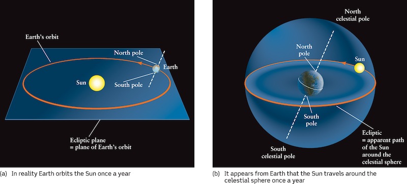
The plane of Earth’s orbit around the Sun is called the ecliptic plane (Figure 2-14a). The ecliptic plane is easy to picture if you imagine hovering above the solar system, but is described quite differently when viewed from Earth. As a result of Earth’s annual motion around the Sun, it appears to us (observing from Earth) that the Sun slowly changes its position on the celestial sphere over the course of a year. (Since we don’t see the Sun and stars at the same time, this motion relative to the stars isn’t readily familiar.) The circular path that the Sun appears to trace out against the background of stars is called the ecliptic (Figure 2-14b). The plane of this path is the same as the ecliptic plane. (The name ecliptic suggests that the path traced out by the Sun has something to do with eclipses. We will discuss the connection in Chapter 3.) Because there are 365¼ days in a year and 360° in a circle, the Sun appears to move along the ecliptic at a rate of about 1° per day. This motion is from west to east, that is, in the direction opposite to the apparent motion of the celestial sphere.
ANALOGY
Note that at the same time that the Sun is making its yearlong trip around the ecliptic, the entire celestial sphere is rotating around us once per day. You can envision the celestial sphere as a merry-go-round rotating clockwise and the Sun as a restless child who is walking slowly around the merry-go-round’s rim in the counterclockwise direction. During the time it takes the child to make a round trip, the merry-go-round rotates 365¼ times.
The ecliptic plane is not the same as the plane of Earth’s equator, thanks to the 23½° tilt of Earth’s rotation axis shown in Figure 2-12. As a result, the ecliptic and the celestial equator are inclined to each other by that same 23½° angle (Figure 2-15).
32
CONCEPT CHECK 2-6
How long does the Sun take to move from being next to a bright star all the way around the celestial sphere and back to that same bright star?
Equinoxes and Solstices
The ecliptic and the celestial equator intersect at only two points, which are exactly opposite each other on the celestial sphere. Each point is called an equinox (from the Latin for “equal night”), because when the Sun appears at either of these points, day and night are each about 12 hours long at all locations on Earth. The term “equinox” is also used to refer to the date on which the Sun passes through one of these special points on the ecliptic.
On about March 21 of each year, the Sun passes northward across the celestial equator at the vernal equinox. This marks the beginning of spring in the northern hemisphere (“vernal” is from the Latin for “spring”). On about September 22, the Sun moves southward across the celestial equator at the autumnal equinox, marking the moment when fall begins in the northern hemisphere (see Figure 2-15). Since the seasons are opposite in the northern and southern hemispheres, for Australians, South Africans, and South Americans the vernal equinox actually marks the beginning of autumn. The names of the equinoxes come from astronomers of the past who lived north of the equator.
33
Between the vernal and autumnal equinoxes lie two other significant locations along the ecliptic. The point on the ecliptic farthest north of the celestial equator is called the summer solstice. “Solstice” is from the Latin for “solar standstill,” and it is at the summer solstice that the Sun stops moving northward on the celestial sphere. At this point, the Sun is as far north of the celestial equator as it can get. It marks the location of the Sun at the moment summer begins in the northern hemisphere (about June 21). At the beginning of the northern hemisphere’s winter (about December 21), the Sun is farthest south of the celestial equator at a point called the winter solstice (see Figure 2-15).
Because the Sun’s position on the celestial sphere varies slowly over the course of a year, its daily path across the sky (due to Earth’s rotation) also varies with the seasons (Figure 2-16). On the first day of spring or the first day of fall, when the Sun is at one of the equinoxes, the Sun rises directly in the east and sets directly in the west.
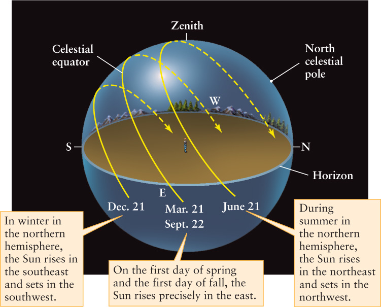
 The Sun’s Daily Path Across the Sky This drawing shows the apparent path of the Sun during the course of a day on four different dates. Like Figure 2-10, this drawing is for an observer at 35° north latitude.
When the northern hemisphere is tilted away from the Sun and it is winter in the northern hemisphere, the Sun rises in the southeast. Daylight lasts for fewer than 12 hours as the Sun skims low over the southern horizon and sets in the southwest. Northern hemisphere nights are longest when the Sun is at the winter solstice.
The closer you get to the north pole, the shorter the winter days and the longer the winter nights. In fact, anywhere within 23½° of the north pole (that is, north of latitude 90° - 23½° = 66½° N) the Sun is below the horizon for 24 continuous hours at least one day of the year. The circle around Earth at 66½° north latitude is called the Arctic Circle (Figure 2-17). The corresponding region around the south pole is bounded by the Antarctic Circle at 66½° south latitude. At the time of the winter solstice, explorers south of the Antarctic Circle enjoy “the midnight sun,” or 24 hours of continuous daylight.
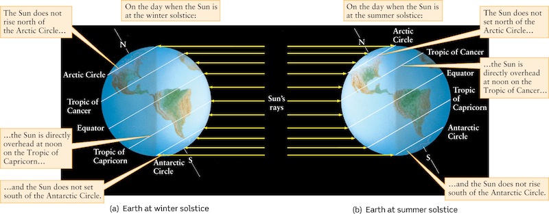
During summer in the northern hemisphere, when the northern hemisphere is tilted toward the Sun, the Sun rises in the northeast and sets in the northwest. The Sun is at its northernmost position at the summer solstice, giving the northern hemisphere the greatest number of daylight hours. At the summer solstice the Sun does not set at all north of the Arctic Circle (Figure 2-18) and does not rise at all south of the Antarctic Circle.
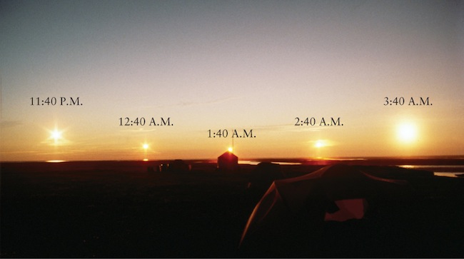
The Midnight Sun This time-lapse photograph was taken on July 19, 1985, at 69° north latitude in northeast Alaska. At this latitude, the Sun is above the horizon continuously (that is, it is circumpolar) from mid-May to the end of July.
34
The variations of the seasons are much less pronounced close to the equator. Between the Tropic of Capricorn at 23½° south latitude and the Tropic of Cancer at 23½° north latitude, the Sun is directly overhead—that is, at the zenith—at high noon at least one day a year. Outside of the tropics, the Sun is never directly overhead, but is always either south of the zenith (as seen from locations north of the Tropic of Cancer) or north of the zenith (as seen from south of the Tropic of Capricorn).
CONCEPT CHECK 2-7
How often each year does an observer standing on Earth’s equator experience no shadow during the noontime sun?
CALCULATION CHECK 2-2
Approximately how many days are there between the summer solstice and the March equinox?