Land Ordinances and the Northwest Territory
The congress ignored western New York and turned instead to the Ohio Valley to make good on the promise of western expansion. Congressman Thomas Jefferson, charged with drafting a policy, proposed dividing the territory north of the Ohio River and east of the Mississippi—the Northwest Territory—into nine new states with evenly spaced east-west boundaries and townships ten miles square. He even advocated giving, not selling, the land to settlers, because future property taxes on the improved land would be payment enough. Jefferson’s aim was to encourage rapid and democratic settlement and to discourage land speculation. Jefferson projected representative governments in the new states; they would not become colonies of the older states. Finally, Jefferson’s draft prohibited slavery in the nine new states.
The congress adopted parts of Jefferson’s plan in the Ordinance of 1784: the rectangular grid, the nine states, and the guarantee of self-government and eventual statehood. What the congress found too radical was the proposal to give away the land; it badly needed immediate revenue. The slavery prohibition also failed, by a vote of seven to six states.
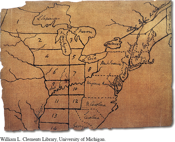
A year later, the congress revised the legislation with procedures for mapping and selling the land. The Ordinance of 1785 called for three to five states, divided into townships six miles square, further divided into thirty-six sections of 640 acres, each section to be subdivided further into family farms (Map 8.2). Reduced to easily mappable squares, the land would be sold at public auction for a minimum of one dollar an acre, with highly desirable land bid up for more. Two further restrictions applied: The minimum purchase was 640 acres, and payment had to be in hard money or in certificates of debt from Revolutionary days. This effectively meant that the land’s first owners would be prosperous speculators. The grid of invariant squares further enhanced speculation, allowing buyers and sellers to operate without ever setting foot on the acreage. The commodification of land had been taken to a new level.[[LP Photo: P08.07 Jefferson’s Map of the Northwest Territory/
Speculators who held the land for resale avoided direct contact with the most serious obstacle to settlement: the dozens of Indian tribes that claimed the land as their own. The treaty signed at Fort Stanwix in 1784 was followed in 1785 by the Treaty of Fort McIntosh, which similarly coerced partial cessions of land from the Delaware, Wyandot, Chippewa, and Ottawa tribes. Finally, in 1786, a united Indian meeting near Detroit issued an ultimatum: No cession would be valid without the unanimous consent of the tribes. For two more decades, violent Indian wars in Ohio and Indiana would continue to impede white settlement (as discussed in chapter 9).
A third land act, called the Northwest Ordinance of 1787, set forth a three-stage process by which settled territories would advance to statehood. First, the congress would appoint officials for a sparsely populated territory who would adopt a legal code and appoint local magistrates to administer justice. When the male population of voting age and landowning status (fifty acres) reached 5,000, the territory could elect its own legislature and send a nonvoting delegate to the congress. When the population of voting citizens reached 60,000, the territory could write a state constitution and apply for full admission to the Union. At all three territorial stages, the inhabitants were subject to taxation to support the Union, in the same manner as were the original states. [[LP Map: M08.02 The Northwest Territory and Ordinance of 1785/

The Northwest Ordinance of 1787 was perhaps the most important legislation passed by the confederation government. It ensured that the new United States, so recently released from colonial dependency, would not itself become a colonial power—at least not with respect to white citizens. The mechanism it established allowed for the orderly expansion of the United States across the continent in the next century.
Nonwhites were not forgotten or neglected in the 1787 ordinance. The brief document acknowledged the Indian presence and promised that “the utmost good faith shall always be observed towards the Indians; their lands and property shall never be taken from them without their consent; and, in their property, rights, and liberty, they shall never be invaded or disturbed, unless in just and lawful wars authorized by Congress.” The 1787 ordinance further pledged that “laws founded in justice and humanity, shall from time to time be made for preventing wrongs being done to them.” Such promises indicated noble intentions, but they were not generally honored in the decades to come.
> PLACE EVENTS
IN CONTEXT
How did the Northwest Ordinance of 1787 reflect the values and ideology of the American Revolution?
Jefferson’s original and remarkable suggestion to prohibit slavery in the Northwest Territory resurfaced in the 1787 ordinance, passing this time with no recorded debate. (See “Analyzing Historical Evidence: The Northwest Ordinance and Slavery.”)The prohibition was paired with a fugitive slave provision promising that escaped slaves caught north of the Ohio River would be returned south. The ordinance thus acknowledged and supported slavery even as it barred it from one region. Still, in the very long run, the stated prohibition of slavery in the Northwest Territory perpetuated the dynamic of gradual emancipation in the North. North-South sectionalism based on slavery was slowly taking shape. [[LP PHOTO: P08.08 A Newly-Cleared Frontier Farm/

Understanding the American Promise 3ePrinted Page 209
Section Chronology