84.1
true
true
Chapter 9: The Islamic World 600-1400
Map Quiz for Chapter 9
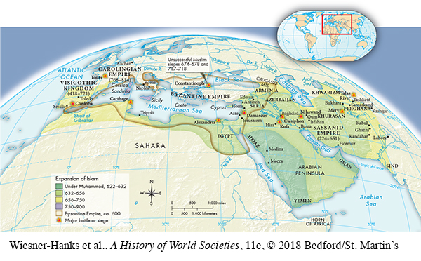
Map of The Expansion of Islam, 622–900
Select the best answer for each question. Click the “Submit” button for each question to turn in your work. Click the "Previous" button to navigate back if you need to view the textbook.
Question
84.1
Correct. The answer is B.
Incorrect. The answer is B.
35HULM4J8z5UJL3pCj2A6AQX/+uuaYtQoTXbi20Uh15nqYjgFW09BzHn6n4o41Ff2KE8/LIQ0qSE+rnwC8lwO6uXooMpuMs+uWGWfyOuH59qrS5rpE3odwIuZLCyeCc5Ek4inSm2B/b10Wo7asN8HrjtfU3yt3SPDSZZ3MghWuXGETOcWV8YcovR2fhpF7eCFW/pxZT/1jRbHtDN11MuGDHHYSUqC9OC/uFFuAVauhhdcv5rDmHH6OCaY2Dw+gzD
Question
84.2
Correct. The answer is D.
Incorrect. The answer is D.
9zaxN51FGVLlFd87Qg3wXR3PnflMEkPlu54pTKgU1vhtkDWyOzSIZNVLbv+vF7KGWVsANQrEzu/yf22Xbr4M3vSAy6lbfp+Un98cyPYG7GwLGjE/jhJgdouZv0WLtgF+Pq5T9tNmSz0TgGL23n9EfX/FqLltmxoSuNnCWLsl3mXplIHBzdIBF3dfE/ZqUUGoZJgxpxOnSPy8zZTF6rGO1uabt5GbGDmJfcG71g==
Question
84.3
Correct. The answer is C.
Incorrect. The answer is C.
s8/JlV1WNZvorWqIwhvuLlO7xqzD3D7Mppkzgu9/XWi8D6iRyXxAgBhyxKsp0R+wE47mdhnrYZNVVaNfTDzywq0rgaOk0O3DVKDkiHXEbrkkKKtK6pVQcXRbeZ2+Cu1VlmdCc9hsz7mZvT4nC19TzHAGuod1dZ85J4iWsPl8DHa0RvYAO9XNnZoKWYkDGNxBVa4lud06R2Ce59xVQqeG8C10HSK5+QNpaNHviAJ3q+Nu0WTb2NzInw==