Chapter 161. Map Quiz for Chapter 29

161.1 Section Title

true
true
Chapter 29: Nationalism in Asia 1914–1939
Map Quiz for Chapter 29
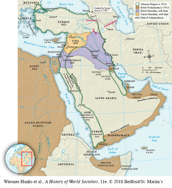
Map shows how the Ottoman Empire was partitioned.  Map shows the Ottoman Empire in 1914 existing across southern Bulgaria, Turkey, the eastern part of Iraq, Seria, western Persia, Palestine, Hejaz, Asir, Yemen, and a narrow stretch of land south of Kuwait to just north of Qatar.  The British Protectorate in 1914 included Egypt, Aden, British Somaliland, Hadhramaut, Oman, Trucial Oman, Kuwait, and Qatar. Iraq (in 1920), Palestine (in 1929), and Lebanon (1920), and Transjordan (in 1929) were part of the British Mandate.  Syria was part of the French Mandate in 1920.
Map of The Partition of the Ottoman Empire, 1914–1923

Select the best answer for each question. Click the “Submit” button for each question to turn in your work. Click the "Previous" button to navigate back if you need to view the textbook.

Question 161.1

Correct. The answer is B.
Incorrect. The answer is B.
AnCQW2KIo+2STq6mqBHHcM6Xvb7Awbu2FdXkXQe18voW3F/cTc/YtCAdb6Rhumy0c9RjOBkRcrjsb5D1bEBq9f91S3blHKmG4PB/ATYdVOmRb0aGNUPklWuWM0JoLIQxe0fNzZtGUhORNi13Li+A6sZywO9QWRBhMnlkyHwpXq0=

Question 161.2

Correct. The answer is A.
Incorrect. The answer is A.
2PCj0T4rhRsfDaAPIZm+tL/e1S6Ke1ximoXepxXFwYaA3nl7BIwlo84Zx7g75U641CzBENdjnPPA2tCGtJ0OZ4fWzsD7zKJRhjMhxBYpF2yXBi1u9HUww9fk3nBuNWjzl4ooO8f9vzZ8cW6E74jp1K2cz/ZKD7nONKToagmkAmsoyJ0KTbDXqg==

Question 161.3

Correct. The answer is C.
Incorrect. The answer is C.
f0PAcIx9szQiZ6fL3+uLUAAuKRT4qAFf6A+3Ku+9hgWuudc/PlAkE/tCKdDmkwgx1fcCB3g3Y9UVMvGxuwssnbwQF46nZ9i3FpyA1E/befKOLxRHONoV6aGrw+eB+daiPySN9zfnJmoYuCFQx6Hlfon/couJR/rMYuYB8qVG7idOwPX7eC0AQJt39DuxkRpfPQaaMUrcFE2t6dYtaIjtST1Fpea9Thjj