2.1 The Four Seasons
Explain what causes seasons and give the major characteristics of the four seasons.
The idea of seasons means different things to different people. For many regions in the tropics, winter is warm and dry and summer brings soaking thunderstorms. At high-
What Causes Seasons?
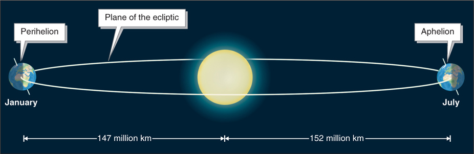
Earth and all the other planets of the solar system orbit (revolve around) the Sun in an ellipse rather than a true circle. The plane of the ecliptic is the flat plane that the orbital paths of the planets in the solar system trace. Because its orbital path is elliptical, Earth is closer to the Sun in January (at a point called the perihelion) than it is in July (at a point called the aphelion) by about 5 million km (3 million mi) (Figure 2.2). The average distance between Earth and the Sun is called an astronomical unit, or AU (1 AU = 149.6 million km or 92.96 million mi). The changing distance between Earth and the Sun does not cause the seasons, however. If it did, it would be warmest in the Northern Hemisphere when Earth is closest to the Sun in January.
plane of the ecliptic
The flat plane traced by the orbital paths of the planets in the solar system.
Question 2.1
What causes seasons?
The tilt of Earth’s axis causes seasons.
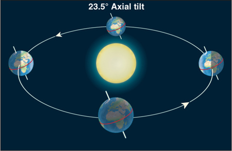
The seasons are caused by the tilt of Earth’s axis. Four components of Earth’s movement and position are necessary to understand how its tilt causes seasons:
Earth’s revolution and the plane of the ecliptic: Earth’s revolution around the Sun follows the flat plane of the ecliptic. Earth does not stray above or below this plane. Each revolution takes 365 days, 5 hours, 48 minutes, and 46 seconds (or 365.25 days) to complete.
Axial tilt: Earth’s axis is tilted 23.5 degrees in relation to the flat plane of the ecliptic (Figure 2.3). If the axis were pointed straight “up,” perpendicular to the plane of the ecliptic, the angle of its tilt would be zero.
Parallel axis: The North Pole points to Polaris (the North Star). As Earth orbits the Sun, the position of Polaris does not seem to move, just as the position of the Sun, Moon, or a distant mountain appears fixed as you drive in a car. Earth’s axis is always parallel to itself in all locations along its orbital path (see Figure 2.3).
Subsolar point: Because Earth’s surface is curved, the Sun’s rays are exactly perpendicular (directly overhead) to Earth’s horizontal surface at only one point at or near noon. This point is called the subsolar point.
subsolar point
The single point at which the Sun’s rays are perpendicular to Earth’s surface at or near noon; restricted to between 23.5° north and south latitude.
As Earth rotates, the subsolar point moves along a constant line of latitude. As we saw in Section GT.3, Earth rotates 1,670 km/h (1,037 mph) at the equator. This means that when the subsolar point is at the equator, it is moving 1,670 km/h. In other words, if you wanted to keep up with the subsolar point, keeping the Sun straight overhead, you would have to travel 1,670 km/h westward along the equator.
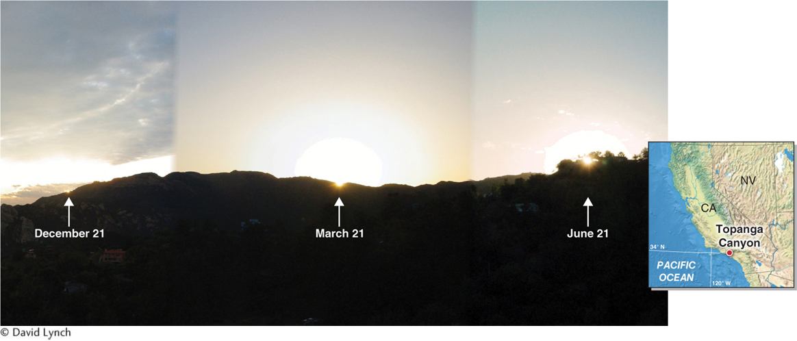
The subsolar point moves gradually north and south over the year as a result of the tilt of Earth’s axis. It never moves farther north than 23.5° north latitude (a parallel called the Tropic of Cancer) or farther south than 23.5° south latitude (a parallel called the Tropic of Capricorn). The latitude of the subsolar point is called the solar declination. For example, when the subsolar point is at the equator, the solar declination is 0 degrees. When the subsolar point is at 10° north latitude, the solar declination is 10 degrees north, and so on. As Figure 2.4 shows, the latitude of the subsolar point is always 90 degrees away from the circle of illumination, the line separating night from day, where sunrise and sunset are occurring.
Tropic of Cancer
The 23.5° north parallel; the maximum latitude of the subsolar point in the Northern Hemisphere.
Tropic of Capricorn
The 23.5° south parallel; the maximum latitude of the subsolar point in the Southern Hemisphere.
circle of illumination
The line separating night from day, where sunrise and sunset are occurring.
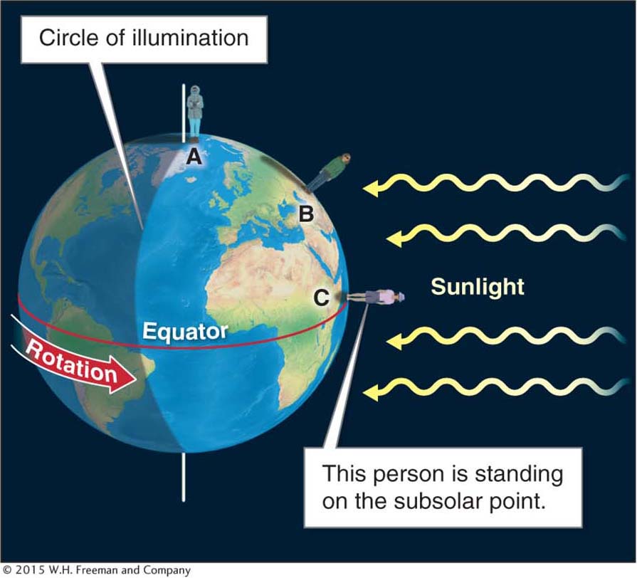
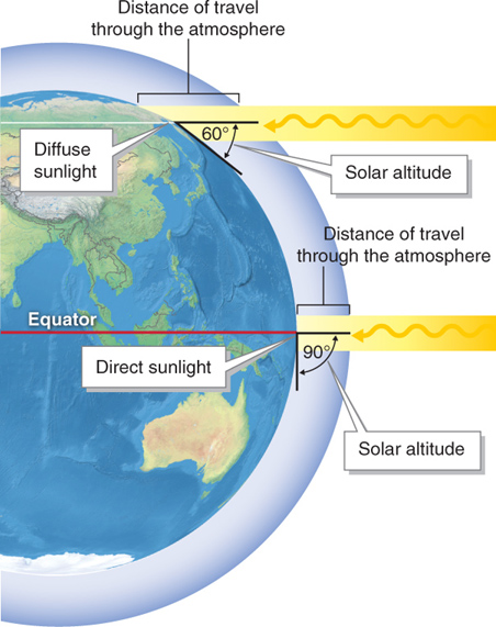
The subsolar point determines the solar altitude, the angle of the Sun above the horizon in degrees. Sunlight on the horizon is at zero degrees, and sunlight that is straight overhead is at 90 degrees. In Figure 2.4, only for person C is the solar altitude 90 degrees.
solar altitude
The altitude of the Sun above the horizon in degrees.
The solar altitude determines the intensity of the noontime Sun. Only in the tropics can the solar altitude be 90 degrees. The noontime solar altitude decreases (the Sun gets closer to the horizon) as one travels to higher latitudes, causing sunlight to become more diffuse (spread out) (Figure 2.5).
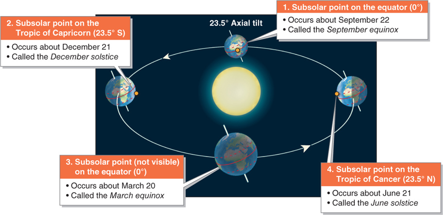
Migration of the Subsolar Point
The subsolar point moves from the Tropic of Cancer to the Tropic of Capricorn, then back again, over a 12-
The December solstice occurs about December 21 each year when the subsolar point arrives at the Tropic of Capricorn. This seasonal event or marker is also called the winter solstice in the Northern Hemisphere. Following this, the subsolar point migrates northward. The March equinox (also called the spring equinox or vernal equinox in the Northern Hemisphere) occurs when the subsolar point crosses the equator about March 20. About June 21, the subsolar point arrives at the Tropic of Cancer, marking the June solstice (or summer solstice in the Northern Hemisphere). From there the subsolar point migrates back south. Three months later, about September 22, it crosses the equator again, marking the September equinox (or fall equinox in the Northern Hemisphere). These seasonal markers are illustrated in Figure 2.7.
December solstice
A seasonal marker that occurs when the subsolar point is at 23.5° south, on about December 21.
March equinox
A seasonal marker that occurs when the subsolar point is over the equator about March 20.
June solstice
A seasonal marker that occurs when the subsolar point is 23.5° north latitude, about June 21.
September equinox
A seasonal marker that occurs when the subsolar point is over the equator about September 22.
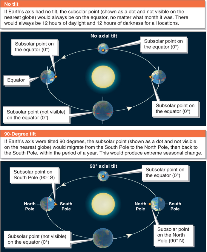
The importance of the tilt of Earth’s axis to seasons is revealed when we imagine what would happen if that tilt were changed significantly (Figure 2.8). If Earth’s axis had no tilt, the subsolar point would always be on the equator, and there would be no seasonal change. If the tilt of Earth’s axis were 90 degrees, the subsolar point would shift from the South Pole to the North Pole and back within a year, and seasonal changes would be much more extreme than they are.
How Does Earth’s Tilt Affect Day Length?
Just as Earth’s axial tilt causes the subsolar point to move across latitudes, it also causes the number of daylight hours to change. To illustrate, we will first look at what happens to day length on the equinoxes.
Day Length on an Equinox
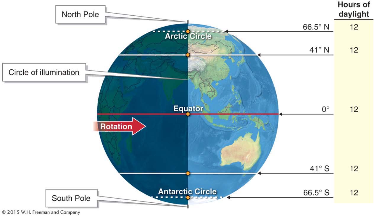
On an equinox, all locations on Earth (except the poles) receive 12 hours of daylight and 12 hours of darkness. At these times, all locations on Earth rotate through equal day and night sides of the planet, as shown in Figure 2.9.
Day Length on the December Solstice
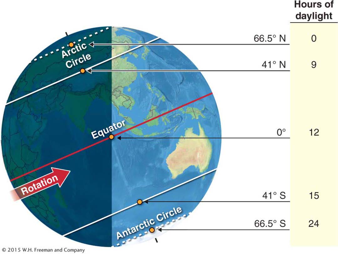
The situation is quite different on the December solstice, when the North Pole is pointed away from the Sun and the subsolar point is directly over the Tropic of Capricorn, at 23.5° south latitude. The equator always receives 12 hours of day and night, but the rest of the planet’s day length varies, and the way it varies depends on the hemisphere.
Day length decreases northward on the December solstice. At the Arctic Circle (at 66.5° north latitude) and northward, there are 24 hours of darkness. Similarly, at the Antarctic Circle (at 66.5° south latitude) and southward, there are 24 hours of daylight (Figure 2.10).
Arctic Circle
The 66.5° north parallel.
Antarctic Circle
The 66.5° south parallel.
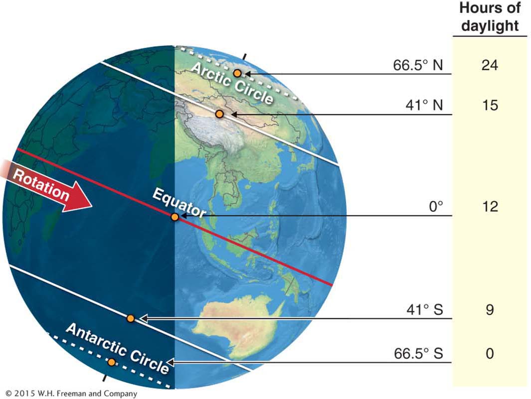
Day Length on the June Solstice
On the June solstice, day length increases northward. On June 21 at the Arctic Circle and northward, the Sun never sets. That is why the high Arctic in summer is often called “land of the midnight Sun” (Figure 2.11).
If you were to stand on the equator for one year, you would see the solar altitude at noon range between 66.5° north (in June) and 66.5° south (in December). In other words, in the tropics, the noon Sun is always high in the sky, and seasonality is negligible. On the other hand, if you were to stand on the North Pole for one year, you would see the noon solar altitude range from 23.5 degrees to the south (in June) to 0 degrees on the horizon (on the September equinox). After the September equinox, the Sun would be below the horizon for six months (until the March equinox). In short, the poles receive six months of continuous darkness, followed by six months of continuous daylight, as if there were one six-
Together, the changing solar altitude and the changing length of daylight hours produce Earth’s seasonality.