4.4 Wind Systems: Sea Breezes to Gravity Winds
Identify local and regional wind systems and explain how they form.
The underlying theme that has been with us since the beginning of Chapter 1 is that the atmosphere is set in motion by uneven heating of Earth’s surface by the Sun. The release of latent heat through condensation and Earth’s rotation also generate winds and determine the direction of airflow. In this section, we examine major local and regional wind systems in the atmosphere. These wind systems can be arranged by their geographic and temporal scales, as summarized in Figure 4.23.
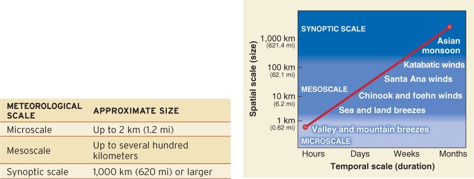
All the wind systems described in this section can locally override global wind patterns. The first two wind systems we explore, sea and land breezes and the Asian monsoon, are created by unequal heating of land and ocean surfaces.
Sea and Land Breezes
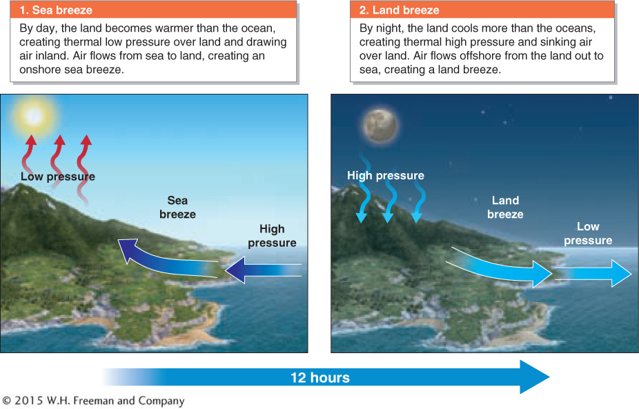
Sea breezes and land breezes are microscale breezes created by heating and cooling differences between water and land (Figure 4.24). Sea and land breezes are most pronounced in the tropics because of strong daytime heating of the land. They also form at midlatitudes, where cold ocean water contrasts with warm temperatures just inland. Given their localized nature, sea and land breezes can easily be disrupted by synoptic-
sea breeze
A local onshore breeze created by heating and cooling differences between water and land.
land breeze
A local offshore breeze created by heating and cooling differences between water and land.
The Asian Monsoon
Like sea and land breezes, the Asian monsoon is created by heating differences between land and sea. The word monsoon is derived from the Arabic mausim, which means “season.” A monsoon is a seasonal reversal of winds, characterized by summer onshore airflow and winter offshore airflow. About half the world’s population experiences the influence of a monsoon system and knows only two seasons: a warm and rainy summer and a slightly cooler but dry winter. The Asian monsoon is the largest monsoon system in the world, and in summer it brings heavy rains, and sometimes flooding, to South Asia.
monsoon
A seasonal reversal of winds, characterized by summer onshore airflow and winter offshore airflow.
The Asian monsoon is separated into the South Asian monsoon, which affects India, and the East Asian monsoon, which affects Indonesia, northern Australia, southern China, Korea, and Japan. All monsoons consist of a summer monsoon, a warm and moist onshore airflow, and a relatively cool (but still warm) winter monsoon, an offshore flow of dry air originating in the continental interior.
In summer, Asian monsoon rains do not necessarily fall every day. Dry break periods can last a few weeks to more than a month. When these break periods are prolonged, drought and crop failures can result. Too little rain brings food shortages and potential famine for millions. When the break periods are short, too much rain results, and flooding, soil erosion, and waterborne disease outbreaks sometimes occur.
The Asian monsoon system is complex, and climatologists still cannot predict with accuracy how it will behave from one year to the next. There are three synoptic-
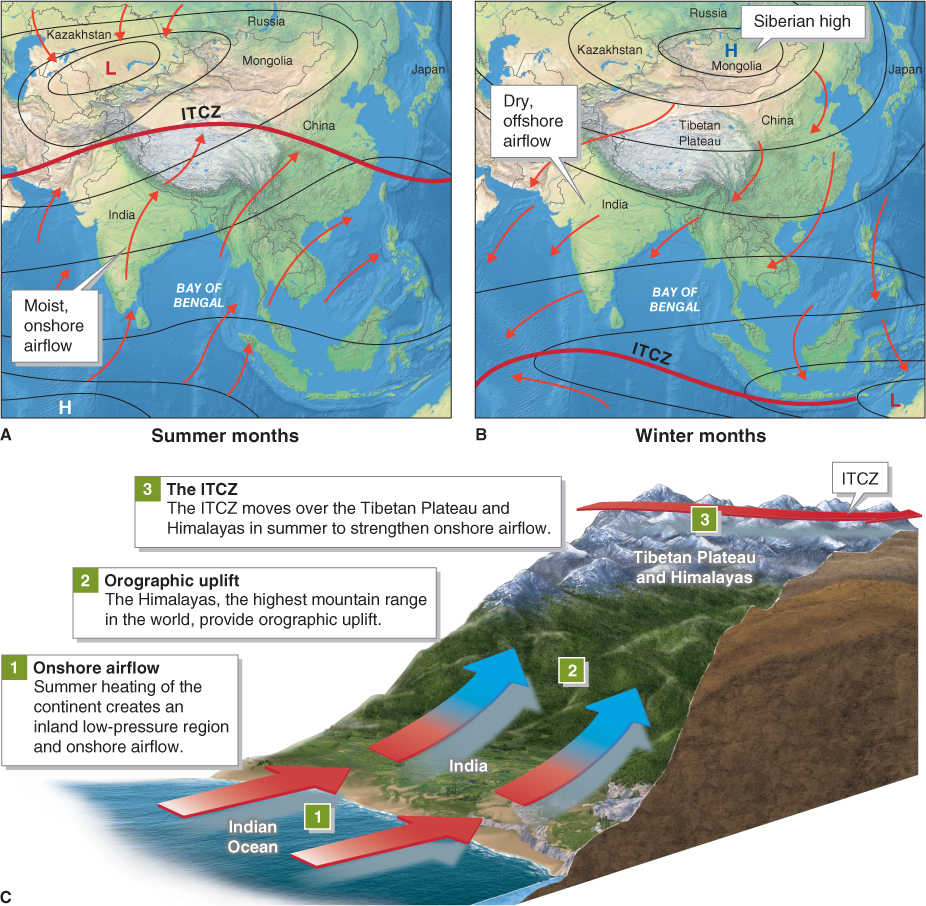
Onshore airflow, orographic uplift, and the ITCZ affect one another and overlap in their influence on the strength, duration, and timing of the South Asian monsoon, creating an unpredictable system. For example, the high Tibetan Plateau acts like a chimney when the ITCZ forms over it and causes heated air to be injected high into the troposphere, further strengthening onshore airflow and precipitation. Extensive snow cover on the plateau can reduce the strength of this chimney effect by cooling the air and making it more stable. This diminishes the strength of the summer monsoon. As Picture This shows, the Asian monsoon brings significant amounts of rainfall to many regions in South Asia.
During the winter monsoon in Asia, the winds reverse and flow from land to sea. The cold interior of the Eurasian landmass develops the semipermanent Siberian high, from which dry air flows outward across Asia and out to sea.
The southwestern United States and northern Mexico also have a monsoon system. During summer, heating over the mountains and the resulting thermal low pressure create a pressure gradient that draws air inland from the warm Gulf of California and the Gulf of Mexico, resulting in summer thunderstorms.
The remaining four wind systems we will describe are all caused by sloped terrain. We will explore them in order of their spatial extent, starting with the most localized winds in mountains.
Picture This
The Wettest Places on Earth
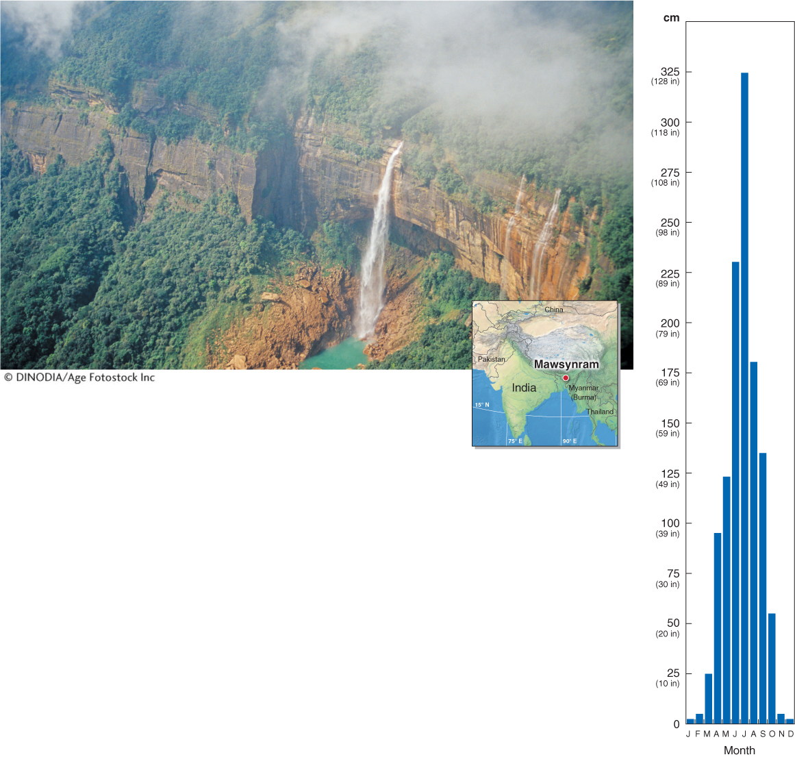
Mawsynram, India, has the distinction of being recognized by Guinness World Records as the wettest place on Earth. Each year it receives an average of 1,187 cm (467.4 in or 38.9 ft) of rainfall (shown with climate diagram at right). It is located in the Khasi Hills in Meghalaya State at about 1,400 m (4,560 ft) elevation. The nearby Nohakali Kai Falls, in Cherrapunji, are shown in this photo.
There are probably wetter locations, but they are not officially recognized. Lloró, Colombia, for example, claims an average yearly rainfall amount of 1,329 cm (523 in or 43.6 ft). Just 11 km (7 mi) to the east of Mawsynram, the town of Cherrapunji also claims to have the world’s highest average annual rainfall. Cherrapunji does hold the official record for the greatest 12-
Consider This
Question 4.7
Why might we expect Mawsynram to be arid? Given what you know about the Asian monsoon, explain the three factors that converge to make Mawsynram so wet.
Question 4.8
What incentive(s) would compel a town to claim to be the wettest location on Earth? How could this incentive affect accurate and truthful measurements of rainfall?
Valley and Mountain Breezes
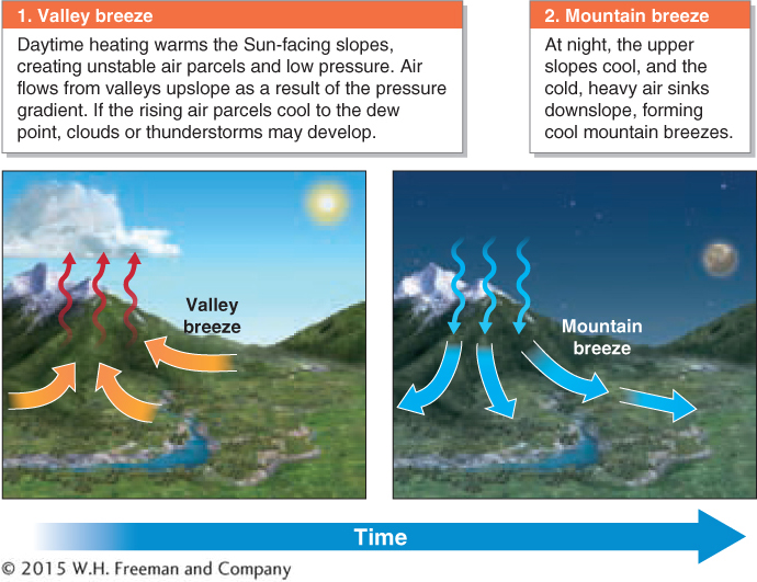
Valley and mountain breezes are local breezes produced by heating and cooling differences in mountainous areas. In summer, mountain slopes that face toward the afternoon Sun are heated and form warm, buoyant parcels of air. As this warmed air rises, it creates a pressure gradient that draws in air from adjacent valley floors, resulting in a valley breeze. As the air parcels rise, they expand and cool adiabatically. If there is sufficient vapor pressure in the rising air parcels, their temperature may drop to the dew point, and condensation will follow. Clouds such as cumulus and cumulonimbus formed from this condensation often produce afternoon summer thunderstorms in mountainous regions as valley breezes develop.
valley breeze
A local upslope breeze produced by heating and cooling differences in mountainous areas.
This situation is reversed after the Sun sets, as upper elevations cool faster than lower elevations. Cold, dense, and heavy mountain breezes flow downslope through canyons, finding the lowest valleys. Mountain breezes are strongest in winter when air is coldest (Figure 4.26).
mountain breeze
A local downslope breeze produced by heating and cooling differences in mountainous areas.
Chinook and Foehn Winds
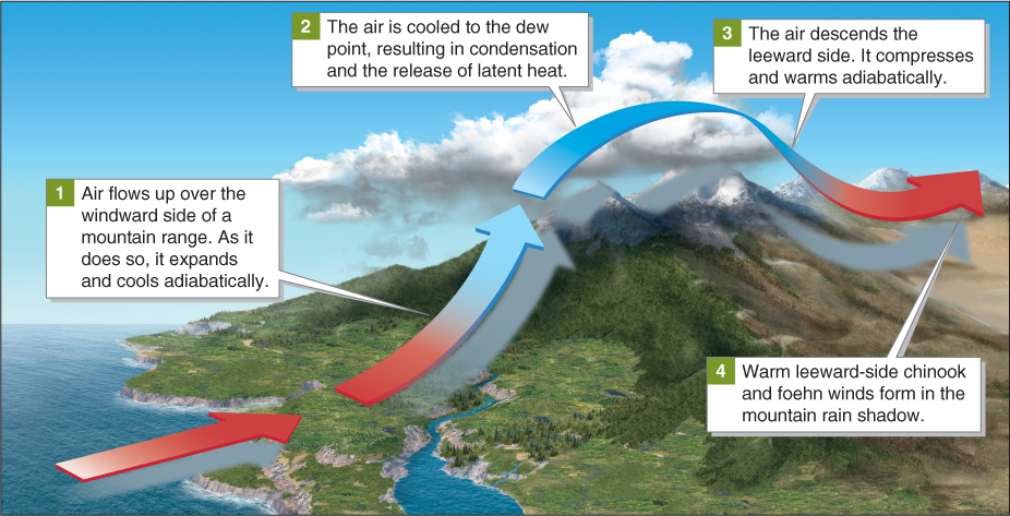
Downslope winds on the leeward side of the Rocky Mountains are called chinook winds. Foehn winds are the same phenomenon in the European Alps, and there are other local names for this type of wind. As we saw in Section 3.3, the leeward side of a mountain range is typically warmer and drier than the windward side. This difference is due to the release of latent heat and precipitation on the windward side and adiabatic heating as air flows down the leeward side (Figure 4.27).
chinook wind
A local downslope wind that forms on the leeward side of the Rocky Mountains.
foehn wind
(pronounced FEH-
Chinook winds are warm, dry winds that often come in sharp contrast to cold winter conditions. With the arrival of chinook winds, temperatures can rise 20°C (36°F) or more within a matter of minutes. These winds quickly melt and sublimate snow.
Santa Ana Winds
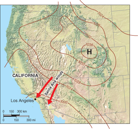
Santa Ana winds sometimes create a major fire hazard for parts of southern California and northern Baja California, Mexico. Santa Ana winds originate in the high desert of the Great Basin and flow to coastal California (Figure 4.28).
Santa Ana winds
Winds that originate in the Great Basin and are heated adiabatically as they descend to sea level on the southern California coast and northern Baja California; often associated with major wildfires.
Santa Ana winds form as high pressure develops in the Great Basin and cool air flows downslope toward coastal southern California. This flow is the result not only of the pressure gradient, but also of gravity, because the cool, relatively dense and heavy air sinks and flows downslope. As the air descends in elevation, it is compressed and warmed adiabatically. Because it originates in the desert, it is dry. Thus the temperature of Santa Ana winds may approach 32°C (90°F), and the relative humidity of these winds is often in the single digits.
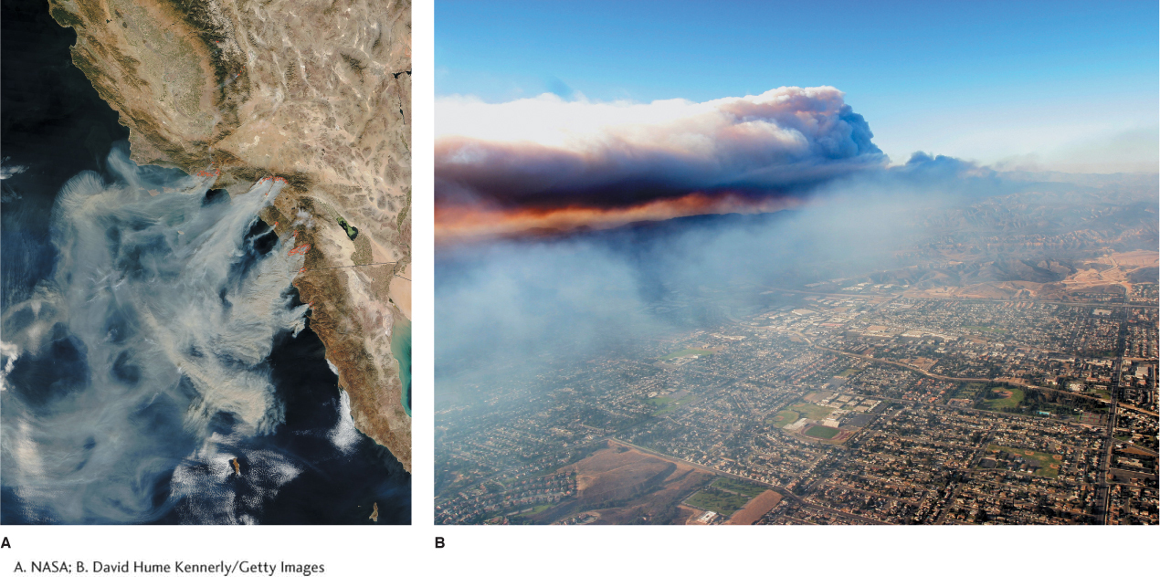
Santa Ana winds occur from fall through spring and usually peak in December.Santa Ana wind speeds can exceed 100 km/h (62 mph) in constricted valleys. Wildfires sometimes burn out of control in these hot, dry winds. As Figure 4.29 shows, rural residences can be vulnerable to Santa Ana wildfires.
Katabatic Winds
Question 4.9
What are gravity winds?
Gravity winds are also called katabatic winds. They are winds that flow rapidly downslope because they are cold and heavy.
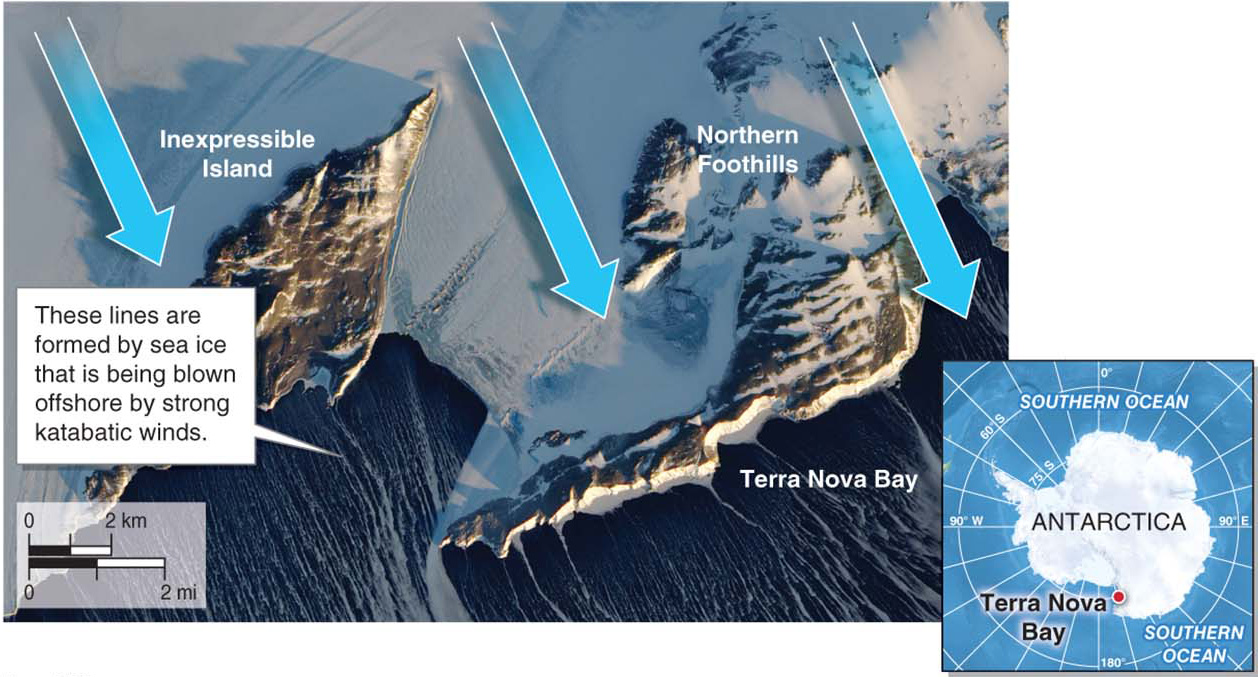
Katabatic winds, or gravity winds (katabatikos is Greek for “downhill movement”), form mainly over ice sheets or glaciers when intensely cold, dense, and heavy air spills downslope by the force of gravity. Katabatic winds are similar to mountain breezes and Santa Ana winds, but they are stronger, cover greater geographic distances, and are far colder. Where airflow is constricted and focused in valleys, the wind speeds can exceed those of hurricanes. Greenland and Antarctica experience katabatic winds commonly, but they can occur wherever high, cold plateaus are found. The effects of katabatic winds can be seen in the satellite image in Figure 4.30.
katabatic wind
(or gravity wind) Wind that forms mainly over ice sheets or glaciers when intensely cold, dense, and heavy air spills downslope by the force of gravity.
