5.1 Thunderstorms
Distinguish among three types of thunderstorms and describe the weather associated with each.
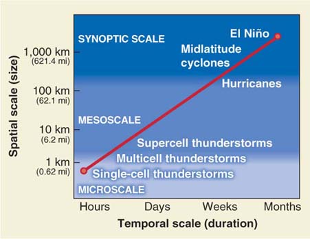
Storm systems derive their energy from solar heating of Earth’s surface and the condensation of water vapor in the atmosphere. In this section we discuss the most localized storm systems, thunderstorms. Subsequent sections examine more geographically extensive storm systems, hurricanes and midlatitude cyclones. Later in the chapter we will explore changes in the global climate system brought on by El Niño. There is a direct relationship between the size and the duration of these atmospheric systems, as Figure 5.2 shows.
Thunderstorms are cumulonimbus clouds that produce lightning and thunder. We explore thunderstorms as isolated systems here to understand how they function. It is important to keep in mind, however, that most thunderstorms do not occur in isolation. They are embedded within larger synoptic-
thunderstorm
A cumulonimbus cloud that produces lightning and thunder.
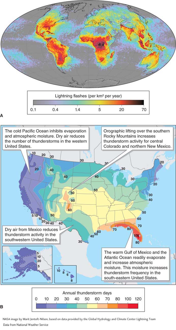
Each day, there are about 40,000 thunderstorms worldwide. At any given time, some 2,000 thunderstorms are in progress somewhere in the world. The southeastern United States, particularly Florida, has the highest frequency of thunderstorms in the country as a result of warm and moist air masses that move north from the Gulf of Mexico (Figure 5.3).
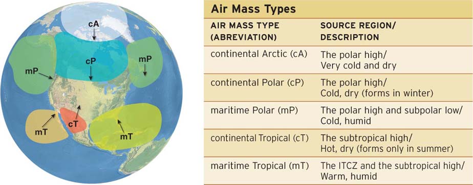
Air masses are necessary components of many meteorological processes, particularly thunderstorms. An air mass is a large region of air, extending over thousands of kilometers, that is uniform in temperature and humidity. When air remains over a region for weeks or longer, it absorbs the characteristics of that region. For example, air over a warm desert will become warm and dry. Air over a warm ocean will become warm and humid.
air mass
A large region of air that is uniform in temperature and humidity.
Air mass types are referred to using abbreviations. Humidity characteristics come first, followed by temperature characteristics (Figure 5.4). For example, “mT” refers to a maritime-
There are three types of thunderstorms: single-
wind shear
Changes in wind speed and direction with altitude.
Single-Cell Thunderstorms
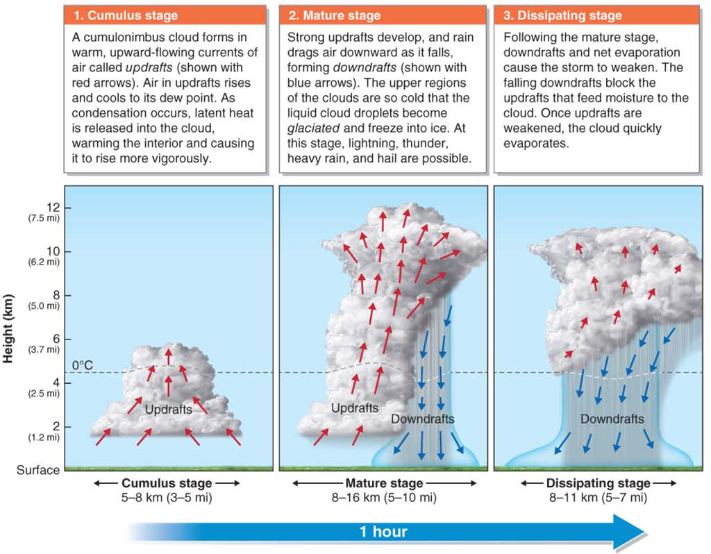
Single-
single-cell thunderstorm
A type of thunderstorm that is short-
Multicell Thunderstorms
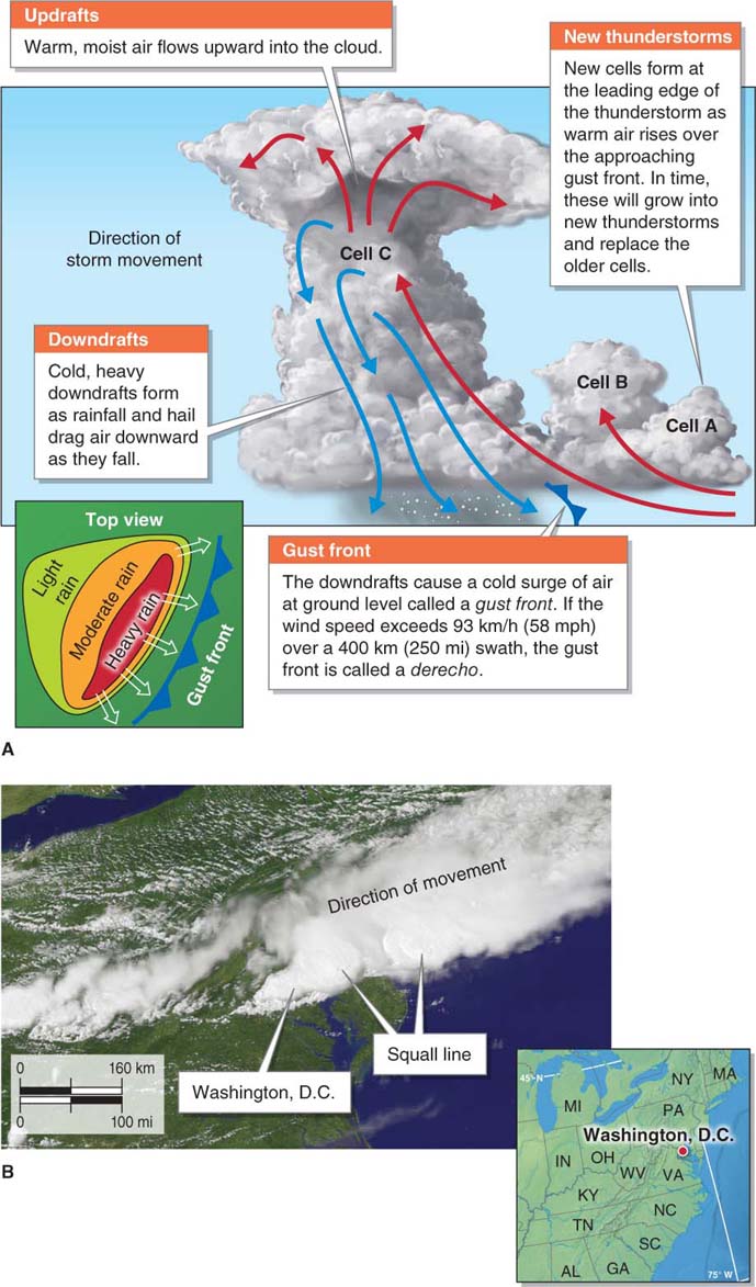
Multicell thunderstorms form under conditions of moderate wind shear with wind speeds of about 40 to 65 km/h or 23 to 40 mph. These mesoscale systems consist of thunderstorm cells organized in long lines or clusters. Multicell thunderstorms often produce severe weather. They differ from single-
multicell thunderstorm
A type of thunderstorm that forms under conditions of moderate wind shear, is organized in squall lines or clusters, and often produces severe weather.
Multicell thunderstorms are sometimes severe and typically last several hours. A severe thunderstorm is defined as one that produces either hail 2.54 cm (1 in) in diameter, a tornado, or wind gusts of 93 km/h (58 mph) or greater. Only about 10% (10,000) of the 100,000 thunderstorms that form in the United States each year are classified as severe.
severe thunderstorm
A thunderstorm that produces eitherhail sized 2.54 cm (1 in) in diameter, a tornado, or wind gusts of 93 km/h (58 mph) or greater.
Individual cells within a multicell thunderstorm persist for only about an hour (like single-
squall line
A line of multicell thunderstorm cells that typically forms along a cold front.
Supercell Thunderstorms
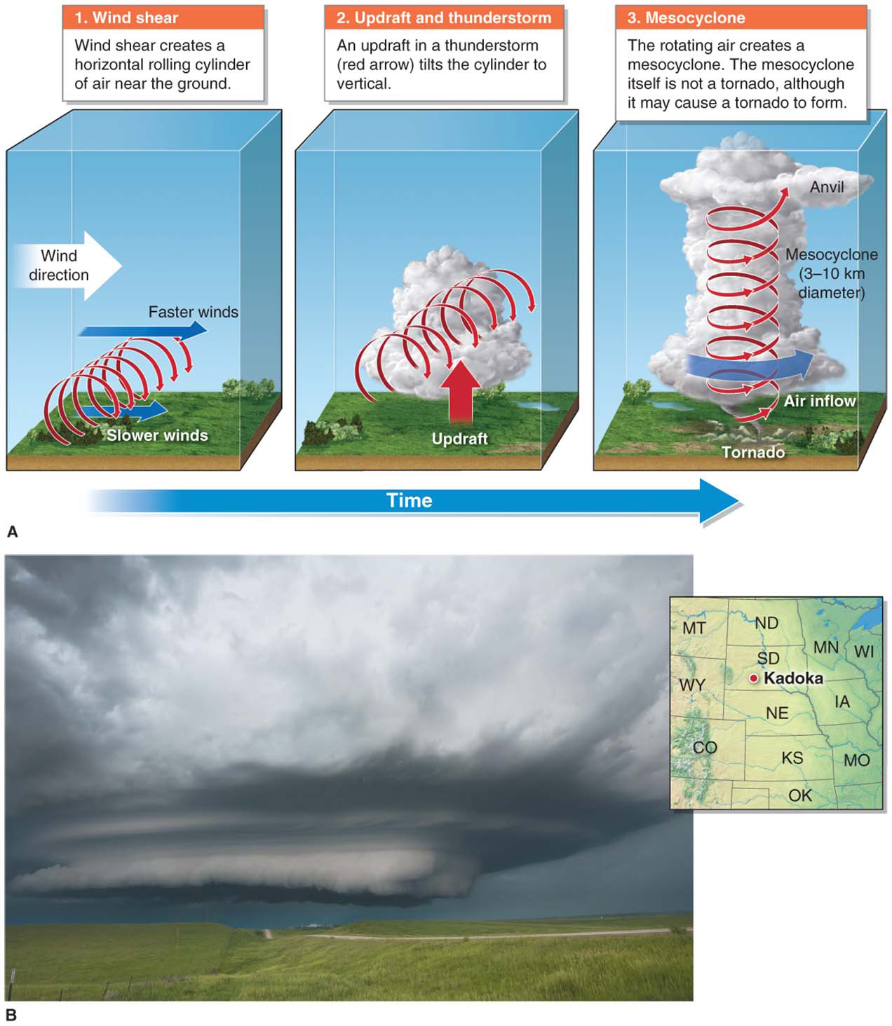
The least common but most powerful thunderstorm type is the supercell thunderstorm, which contains a rotating cylindrical updraft. Supercell thunderstorms usually produce severe weather. Almost all powerful tornadoes are produced by supercell thunderstorms.
supercell thunderstorm
A thunderstorm with a rotating cylindrical updraft that usually produces severe weather.
Question 5.1
Why do some thunderstorms rotate?
Wind shear sometimes causes updrafts in thunderstorms to rotate.
Supercell thunderstorms form over land where there is humid air and strong wind shear. These conditions frequently occur in spring in North America over the southern Great Plains in Kansas and Oklahoma. The term supercell refers to the thunderstorm as a whole, and the term mesocyclone refers to the rotating cylindrical updraft within the supercell. Figure 5.7 outlines how a mesocyclone develops within a thunderstorm.
mesocyclone
The rotating cylindrical updraft within a supercell thunderstorm.