5.4 Midlatitude Cyclones
Review the major characteristics and stages of development of a midlatitude cyclone.
In Section 4.2, we learned that a cyclone is any meteorological system that rotates counterclockwise (in the Northern Hemisphere) around a low-
midlatitude cyclone
(or extratropical cyclone) A large cyclonic storm at midlatitudes.
Midlatitude cyclones bring storms from fall through spring between approximately 30° and 70° latitude in both hemispheres. In the Northern Hemisphere, the United States, most of Canada, Europe, and Asia are influenced by these large storm systems, which move from west to east with the westerlies. Some 10 to 20 midlatitude cyclones are in progress at any given time worldwide. They are the largest storm systems on the planet, having a diameter of 1,600 km (1,000 mi) or more. In some cases, they become as strong as hurricanes at sea level. In mountainous regions, they commonly produce hurricane-
Anatomy of a Midlatitude Cyclone
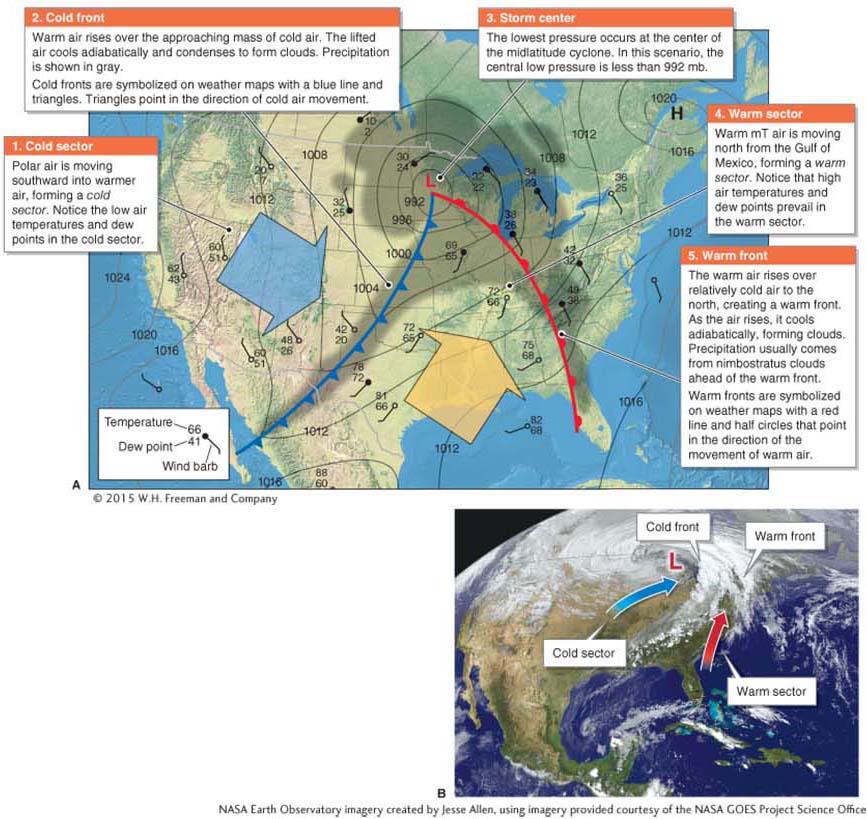
There are many different permutations of midlatitude cyclones, depending on the types of air masses that are interacting and the characteristics of geostrophic winds aloft. Most midlatitude cyclones are composed of a warm front and a cold front. A warm front is produced when warm air advances on and flows over cooler, denser air. Warm fronts may bring precipitation, but they are rarely associated with severe weather. A cold front is a region where cold, dense air advances on relatively warm and less dense air. Cold fronts are sometimes associated with severe weather. The different densities of warm and cold air prevent air masses from mixing together as they converge. Without this characteristic, frontal systems would not form. Figure 5.22 illustrates how fronts may combine to form a midlatitude cyclone.
warm front
A region where warm air advances on and flows over cooler,heavier air; not associated with severe weather.
cold front
A region where cold air advances on relatively warm air; sometimes associated with severe weather.
Effects of Midlatitude Cyclones on Weather
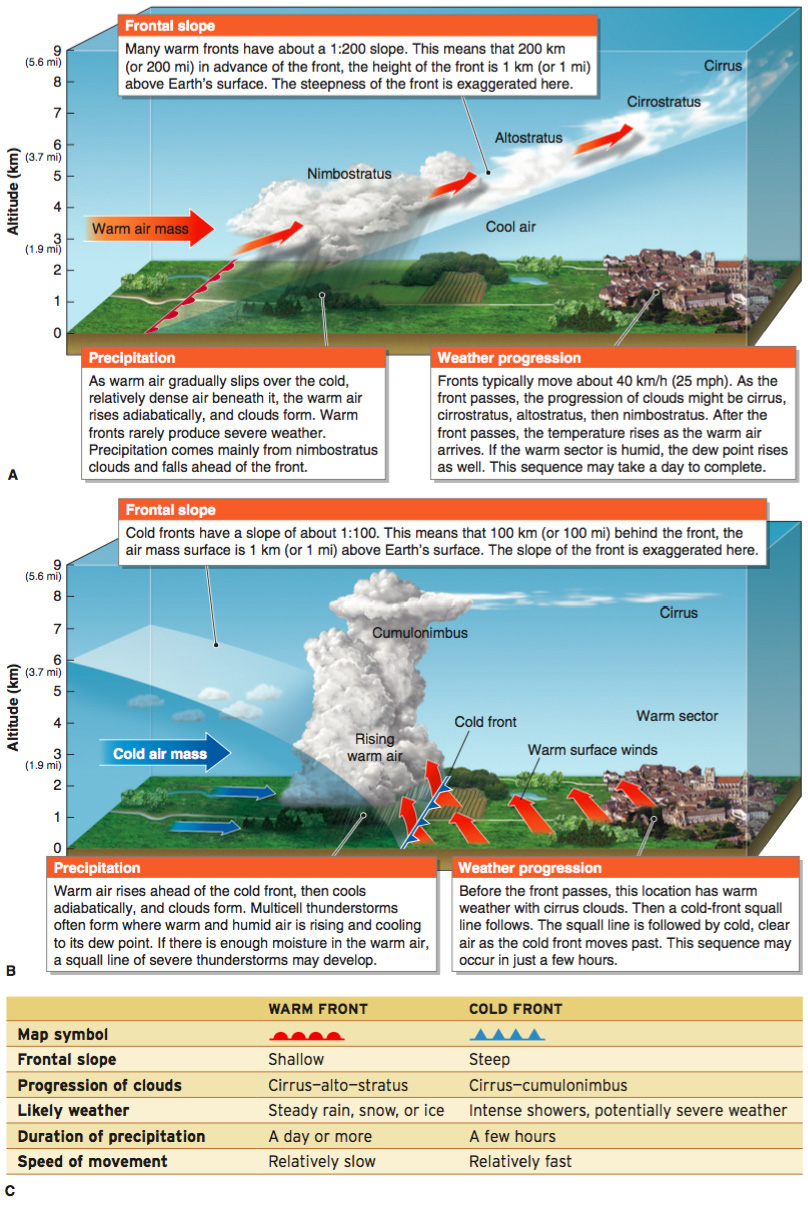
As a midlatitude cyclone moves over a region, the weather experienced in that region will reflect the type of front moving through. In most cases, a warm front moves through the region first and is followed by a cold front. Warm fronts are usually associated with nimbostratus clouds that bring steady precipitation. Cold fronts are usually associated with cumulonimbus clouds that bring short bursts of rainfall and potentially severe weather. Figure 5.23 diagrams the typical characteristics and weather patterns of frontal systems.
Life Cycle of a Midlatitude Cyclone
Like a single-
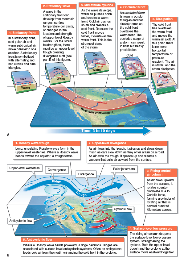
Most midlatitude cyclones begin as waves in the subpolar low. If an upper-
One particularly important type of midlatitude cyclone is called a nor’easter. These powerful storms bring blizzard-
nor’easter
A typeof midlatitude cyclone that brings blizzard-
After midlatitude cyclones move over the Great Lakes, the cold air behind them often creates lake-
lake-effect snow
Heavy snowfall that results as cold air moves overlarge, relatively warm bodies of water, such as the Great Lakes.
Picture This
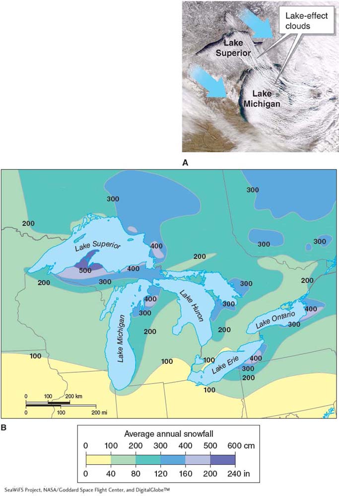
Lake-
The satellite image (part A) shows wind direction (with arrows) over Lake Superior and Lake Michigan and downwind lake-
Consider This
Question 5.5
Why do large lakes produce more lake-
effect snows than small lakes? Question 5.6
If the water temperature decreased in the Great Lakes, would lake-
effect snows increase or decrease? Explain.