Describe the major characteristics of mid- and high-latitude biomes and human impacts in each.
In this section, we continue traveling higher in latitude as we survey Earth’s biomes. Midlatitudes, or temperate latitudes, are the transitional regions between warm subtropical air and cold polar air. Temperate biomes experience a large annual temperature range if they are far from the moderating effects of the oceans, but have a smaller annual temperature range if they are near the coast. The five biomes found at middle and high latitudes are temperate grassland, the Mediterranean biome, temperate deciduous forest, temperate rainforest, and boreal forest.
Temperate Grassland
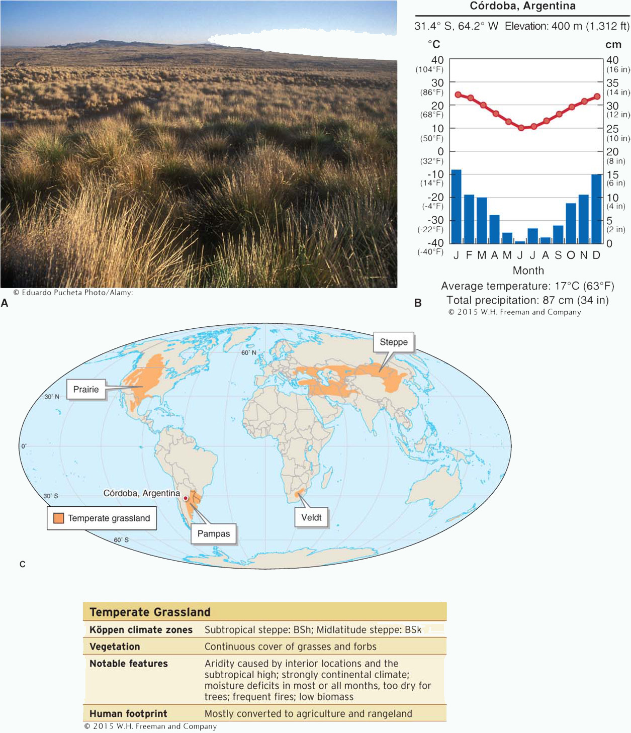
The temperate grassland biome is largely dominated by grasses. It is characterized by significant moisture deficits for most of the year, natural fires, and grazing herbivores, all of which keep trees from becoming established. Temperate grasslands are found mostly between 30 and 60 degrees latitude in continental interiors. They go by several local names: prairie in North America, pampas in South America, steppe in Eurasia, and veldt in South Africa (Figure 8.13).
Temperate grassland.(A) The pampas grassland biome near Córdoba, Argentina. (B) Climate diagram for Córdoba. (Note that Córdoba is in the Southern Hemisphere, so the temperature is coolest in June through August.) Most temperate grassland regions have a large annual temperature range, with warm summers and cold winters. Average annual temperatures vary from 18°C (64°F) in South Africa to 2°C (35°F) or less in Canada and Eurasia. Precipitation in grasslands ranges from 30 to 100 cm (12 to 40 in). (C) Temperate grasslands occur extensively in interior North America, Eurasia, southern South America, and southern Africa. There are also scattered temperate grasslands in Madagascar, New Zealand, California, and Australia. Grasslands go by many local names, as shown on this map.
A grass-dominated biome characterized by significant moisture deficits, natural fires, and grazing herbivores.
About 90% of the plant biomass in temperate grasslands is grasses, but grasses comprise only about 20% of the species diversity. Forbs (non-grass herbs) such as milkweed (Asclepias spp.), purple coneflower (Echinacea purpurea), and black-eyed susan (Rudbeckia spp.) greatly increase the plant biodiversity in grasslands in North America. Most of the grassland biomass is found in the roots of grasses, which may have a biomass some three times greater than the aboveground portions of the plant. Generally, taller grasses have deeper and more extensive root systems than shorter grasses.
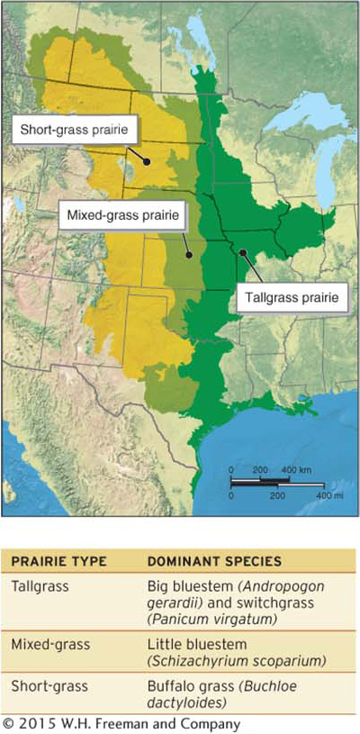
Before its conversion to agriculture, the temperate grassland of North America was dominated by three prairie types: tallgrass prairie in the eastern Great Plains, mixed-grass prairie in the central Great Plains, and short-grass prairie in the western Great Plains (Figure 8.14).
Map of prairie types of North America.The height of grasses decreases westward, reflecting the increasing aridity in interior North America. The grassland-desert ecotone lies on the the western margin of the short-grass prairie.
Page 269
Page 270
Human Footprint
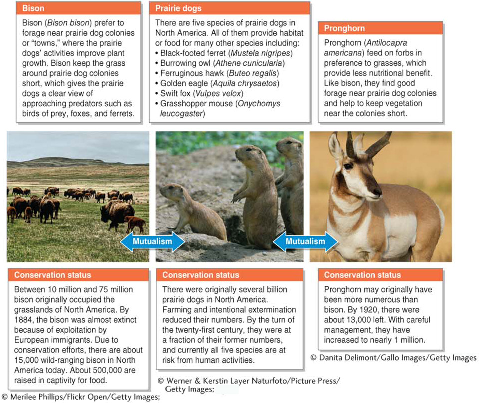
The temperate grassland biome has been greatly reduced in its geographic extent. This biome is a desirable place for people to live, farm, and raise livestock. Roughly 80% of the original North American prairie is now either developed or being used for commercial agriculture and cattle ranching. The North American grassland ecosystem had many animal species whose populations collapsed with the loss of these grasslands during the early twentieth century. Prairie dogs (Cynomys spp.) were important keystone species and are explored further in Figure 8.15.
GEO-GRAPHIC: Prairie dogs and their partners.Prairie dogs are keystone species in North American temperate grasslands. They are mutualistic partners of many grassland organisms, including bison and pronghorn. In addition, prairie dog burrowing improves plant growth in grasslands by aerating the soil and allowing water to better infiltrate the ground. The animals also add nitrogen to the soil with their fecal pellets.
Where temperate grassland has not been converted to agriculture, extensive grazing by cattle has altered this biome. Cattle grazing has changed nearly all of the North American short-grass prairie by allowing non-native plant species to establish themselves and become dominant. Where cattle are grazed intensively, as many as 90% of the plant species are non-native weeds. Moderate cattle grazing, however, can simulate the effects of grazing by the now-scarce bison, to which grasses are adapted, and may therefore be beneficial for the prairie ecosystem. Grassland restoration managers are increasingly seeing the value of cattle as a stand-in for native grazers.
The Mediterranean Biome
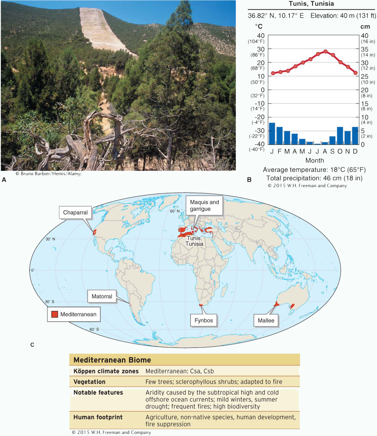
The smallest and perhaps most unusual climate zone is that found in the Mediterranean biome. The Mediterranean biome is characterized by hot, dry summers and winter rainfall. Three physical factors control the vegetation structure of the Mediterranean biome: (1) extended summer drought lasting five months or longer, (2) frequent fires, and (3) low soil nutrients and soil organic matter. Many of its plants are adapted to drought and fire. About half the world’s area of this biome is found in the Mediterranean region of southern Europe and northern Africa (Figure 8.16).
The Mediterranean biome.(A) This photo near Tunis, Tunisia, shows the shrubland vegetation structure of the Mediterannean biome. The white strip on the hillside is a firebreak made by people that is designed to contain wildfires. (B) Climate diagram for Tunis. Average annual temperatures in the Mediterranean biome range from 5°C to 20°C (41°F to 68°F), and annual precipitation totals average 50 to 120 cm (19 to 47 in). (C) The Mediterranean biome is centered at about 35 degrees latitude, and it is geographically isolated on the western margins of five different continents. With the exception of the Mediterranean region itself, all of these locations have cold ocean currents offshore that inhibit evaporation of seawater and increase aridity. The Mediterranean biome goes by several different local names in these locations, as shown on this map.
A biome characterized by hot, dry summers and winter rainfall, with vegetation adapted to drought and fire.
The Mediterranean biome has high biodiversity and high endemism, meaning that many species are geographically restricted to it. The fynbos of South Africa and the chaparral of California, for example, each have about 6,000 different plant species. The Mediterranean region has more than 7,000. About half of all plant species in the Mediterranen biome are annuals. A few perennials are summer deciduous. Many plants of this biome have sclerophyllous leaves, which are hard, leathery, waxy leaves adapted to reduce water loss and herbivory.
sclerophyllous
Having stiff, leathery, and waxy leaves adapted to reduce water loss and herbivory.
Many plants of the Mediterranean biome display fire-adapted traits, such as serotinous cones, crown sprouting, and thick bark (see Section 7.4). The ecological health of the Mediterranean biome is dependent on fire. Fires cycle nutrients back into the soil and stimulate germination of seeds and vegetation regrowth.
Page 271
Human Footprint
The main anthropogenic agents of change in the Mediterannean biome are agriculture and urban development, overgrazing of livestock (particularly by sheep and goats around the Mediterranean Sea), fire suppression, and non-native plants. California has been particularly hard hit in this last regard, as more than 1,000 non-native plants have established populations there. The native perennial grasses of California have been almost completely replaced by non-native annual species, mostly from the Mediterranean region. The Mediterranean region, in turn, has been invaded by plants from California.
Temperate Deciduous Forest
Temperate forests reflect the precipitation caused by the subpolar low at midlatitudes. There are two kinds of temperate forest: temperate deciduous forest and temperate rainforest.
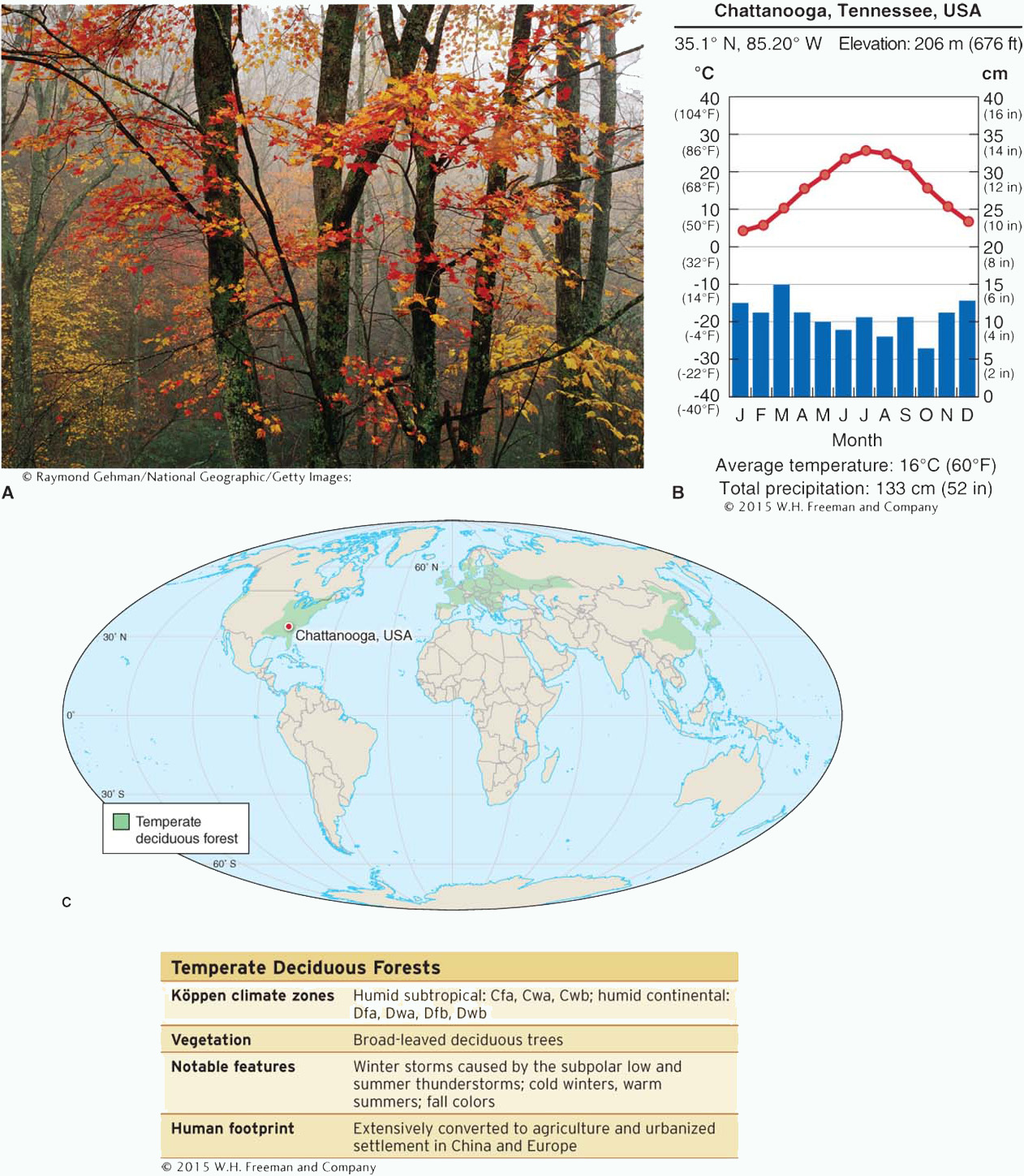
The temperate deciduous forest biome is dominated by trees that shed their leaves in winter in response to low temperatures. Examples of such trees include oak (Quercus), maple (Acer), elm (Ulmus), and beech (Fagus). This biome occurs at midlatitudes where the annual temperature range is large and winters bring below-freezing temperatures. As the map in Figure 8.17 shows, this biome is found mainly in the Northern Hemisphere because there is more land at mid-latitudes there than in the Southern Hemisphere.
Temperate deciduous forest.(A) Temperate deciduous forest in Cherokee National Forest, near Chattanooga, Tennessee. (B) Climate diagram for Chattanooga. Average annual temperatures in the temperate deciduous forest biome vary from 2°C to 20°C (35°F to 68°F). Average annual precipitation ranges from 50 to 250 cm (20 to 98 in). (C) Temperate deciduous forest is or was located mainly in eastern North America and western Europe, and it was formerly found in eastern Asia. To a lesser extent, it is also found at midlatitudes in South America, Australia, and New Zealand (not shown here).
A biome dominated by trees that shed their leaves in winter in response to low temperatures.
Page 272
Page 273
Page 274
The deciduous trees in these forests lose their leaves through abscission, a process triggered by change in light and moisture conditions in the fall. They often turn bright colors as they lose their green chlorophyll, revealing brighter-colored anthocyanin pigments beneath.
Human Footprint
In the temperate deciduous forest biome, much of the primary forest has been lost to agriculture and human settlement. Primary forest is forest that has never been significantly modified by people. The soils of the temperate deciduous forest are fertile and well suited for farming once the forest has been cleared. Logging for hardwood lumber has also reduced the extent of temperate deciduous forests.
primary forest
Forest that has never been significantly modified by people.
Question
8.9
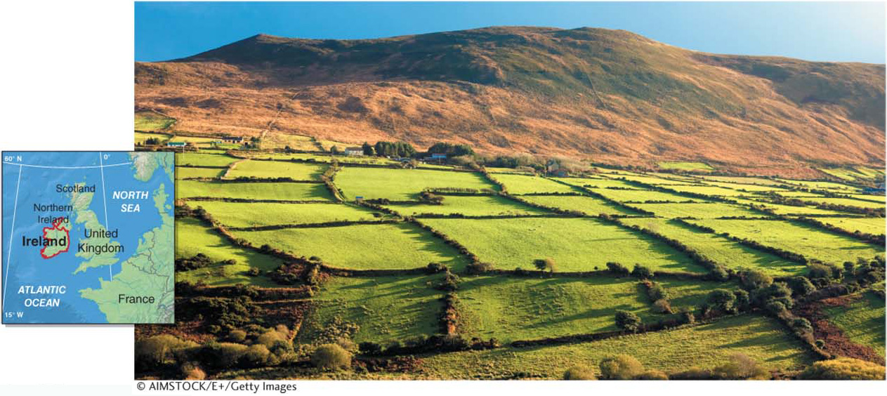
Why is Ireland mostly treeless?
Temperate deciduous forests in Ireland and most of northern Europe were cut by people long ago. If left to nature, the forests would return after centuries.
Today, the British Isles, much of Europe, and eastern China have few forests. Instead, they support extensive agricultural systems. The forests in these areas were cleared beginning some 8,000 years ago. Human activities keep the land under agricultural production even though the climate is suitable for the return of forest (Figure 8.18).
Agricultural fields in County Kerry, Ireland.Ireland, like most of northern Europe, has a climate that supports temperate deciduous forest. Throughout Europe, forests were cleared several thousand years ago for farming and livestock grazing. This entirely anthropogenic landscape is maintained by people. If left alone, it would develop into oak and pine forest through ecological succession over many centuries.
Forests that have been cleared or disturbed and regrown are called secondary forests. Secondary forests usually have lower biodiversity than primary forests. In some areas, the temperate deciduous forest has rebounded after having once been cut. In eastern North America, for example, deciduous forests are more geographically extensive and less damaged by acid rain today than they were a century and a half ago. Legislation such as the Clean Air Act in the 1970s (see Section 1.4) and a long-term trend of people moving away from rural areas are responsible.
secondary forest
Forest that has regrown after being disturbed or cleared by people.
Temperate Rainforest
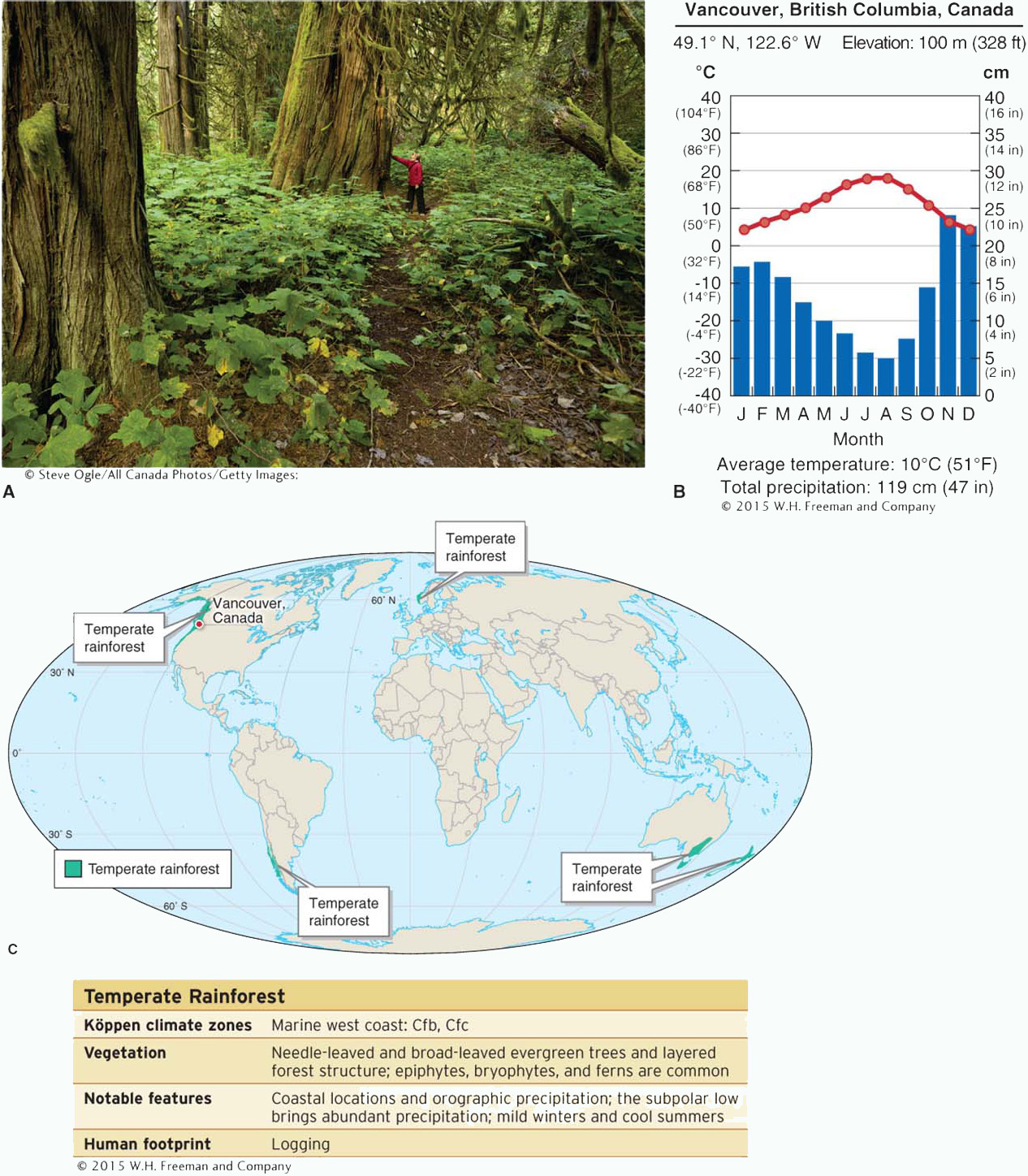
Compared with temperate deciduous forest, temperate rainforest is geographically limited, and far fewer people ever see it. The temperate rainforest biome occurs where annual precipitation is high and temperatures are mild. It is characterized by large trees that form a dense canopy. In the Northern Hemisphere dominant tree species include western red cedar (Thuja plicata), sitka spruce (Picea sitchensis), and western hemlock (Tsuga heterophylla). The California redwood (Sequoia sempervirens) dominates most coastal areas of California. A dense understory layer of vegetation lies beneath the trees. Many epiphytic species, such as ferns, lichens, and bryophytes (mosses and their relatives), thrive in the canopy.
temperate rainforest
A forest biome found mostly on the west coasts of continents where annual precipitation is high; typically has large trees forming a dense canopy.
Many temperate rainforests are located along the western coasts of continents, where abundant precipitation, fog, and high humidity occur. Evergreen needle-leaved trees dominate this biome in the Northern Hemisphere. In the Southern Hemisphere, evergreen broad-leaved trees, such as the southern beech (Nothofagus) and Eucalyptus, are more common. As the climate diagram in Figure 8.19 shows, the temperate rainforest receives more precipitation, and has a more moderate maritime climate, than the temperate deciduous forest.
Temperate rainforest.(A) Temperate rainforest near Vancouver, British Columbia, Canada. Because of the abundant precipitation and mild temperatures, immense trees dominate these forests if they have not been logged. (B) Climate diagram for Vancouver. Summers are cool and winters are mild. Average annual temperatures in the temperate rainforest biome range from about 3°C to 20°C (37°F to 68°F). Average annual rainfall ranges from 170 to 350 cm (67 to 138 in), and precipitation falls in all months. (C) The temperate rainforest biome is scattered throughout midlatitudes where precipitation is sufficient to support it. The largest intact temperate rainforests are along the coasts of western North America, southern Chile, and southeastern Australia.
The future of the temperate rainforest biome has become a political issue, as different sides have fought either to use it for profit or to preserve it. California redwoods, for example, make prized outdoor decking and furniture because of the rot-resistant qualities of their wood. Logging that began in the late 1800s and continued through much of the twentieth century cleared large expanses of old-growth groves of redwoods. Today, only about 5% of the original temperate rainforest in California, Oregon, and Washington has remained unlogged. In British Columbia, about 50% remains, and Alaska has about 90% of its original temperate rainforest, most of it is found in the Tongass National Forest which has largely been protected from logging. Worldwide, about half of the temperate rainforest has been cut. In many areas, temperate rainforest is actively managed as a timber resource.
Boreal Forest
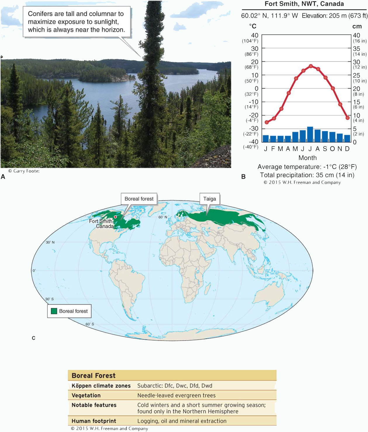
The boreal forest is a cold coniferous forest biome found in North America and Eurasia. The boreal forest is among the largest biomes, comprising about one-fourth of all forested land on Earth. This biome occurs in continental interiors where there are low winter temperatures and a short summer growing season. As Figure 8.20 shows, the boreal forest is not found in the Southern Hemisphere due to the lack of interior continental climates there. Its vegetation is dominated by coniferous, or cone-bearing, trees, most of which are needle-leaved and evergreen. Dominant coniferous tree species of this biome include pine (Pinus), spruce (Picea), fir (Abies) and larch (Larix).An understory of mosses, lichens, and herbaceous plants lies beneath the canopy.
Boreal forest.(A) The boreal forest near Fort Smith, Northwest Territories, Canada. (B) Climate diagram for Fort Smith. Average annual temperatures in the boreal forest biome range from -5°C to 3°C (23°F to 37°F). Annual precipitation averages 40 to 200 cm (16 to 79 in). (C) The boreal forest, called taiga in Eurasia, extends across North America and Eurasia. It is centered at about 60 degrees north latitude.
A cold coniferous forest biome found in North America and Eurasia, with vegetation made up of needle-leaved evergreen trees and an understory of mosses, lichens, and herbaceous plants.
Fire can be an important factor in the boreal forest during the summer. The fire-return interval ranges from a few decades in the southern portions of the boreal forest to over a thousand years at the northern edge of the forest.
Human Footprint
The boreal forest is the most sparsely populated forested region on Earth. Vast tracts through Eurasia and North America have remained mostly unaltered by people. This is quickly changing, however, as world demand grows for forest products, such as paper and lumber, and minerals, such as petroleum. Recent open-pit mining in Alberta’s tar sand deposits has generated considerable conflict between the energy industry’s political representatives and those seeking cleaner fuels with fewer environmental impacts in the United States and Canada.