12.2 Plate Tectonics: An Ocean of Evidence
Describe the evidence used to develop the theory of plate tectonics and explain how lithospheric plates move.
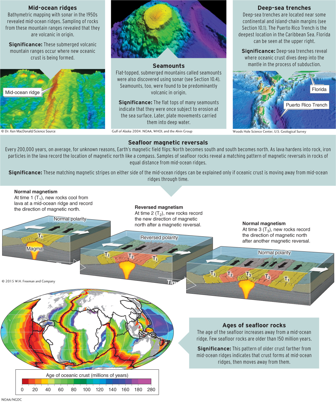
In 1912, when Wegener first proposed his theory of continental drift, almost nothing was known about seafloor bathymetry. Following World War II, emerging seafloor research methods using sonar provided new evidence that led to the development of the theory of plate tectonics.
One important research tool was the ship Glomar Challenger. The Challenger could drill 1.6 km (1 mi) long samples from seafloor rock in water 5 km (3 mi) deep. Researchers aboard this vessel sampled rock materials in the Atlantic Ocean along a transect (or line) that crossed the mid-
Harry Hess is considered one of the founders of plate tectonics. In 1960, he formalized the theory of seafloor spreading, which eventually developed into the broader theory of plate tectonics. Hess used data on the ages of seafloor rocks and on patterns of magnetism in those rocks to propose that new oceanic crust forms at mid-
subduction
The process in which oceanic lithosphere bends and dives into the mantle beneath another lithospheric plate.
Plate Tectonics: The Current Model
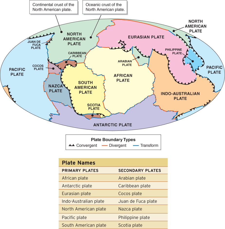
According to the current model of plate tectonics, the lithosphere is broken into 14 major plates and many smaller fragments, all of which move independently of one another across the surface of the planet. These plates lie atop the convecting asthenosphere and are set in motion by it. The plates are not floating on a sea of molten rock. The rocks of the asthenosphere are hot, but they are under great pressure and, as a result, they do not melt. Instead, the asthenosphere is solid rock that is plastic and can deform and slowly flow, like warm (but not melted) wax (see Section 11.3).
The margins of the lithospheric plates are called plate boundaries. The large plates are called primary plates and smaller plates are called secondary plates. There are seven primary and seven secondary plates. The largest plate is the Pacific plate (Figure 12.7).
plate boundary
The margin of a lithospheric plate.
plate boundaries
The margins of lithospheric plates.
How Do We Know Where the Plate Boundaries Are?
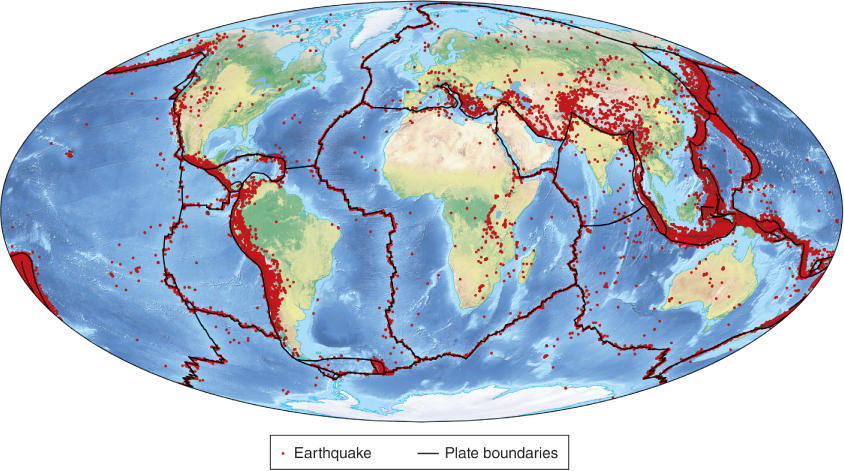
The geographic pattern of earthquakes reveals where plate boundaries are. After World War II, scientists began placing extensive networks of seismometers around the ocean basins to measure and record earthquake activity. To their astonishment, they found that earthquakes were not randomly distributed, as they had anticipated. Instead, as shown in Figure 12.8, earthquakes occur in a geographic pattern that delineates the outlines of the lithospheric plates.
How Do the Plates Move?
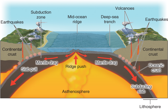
When the theory of plate tectonics was first proposed, it was assumed that the underlying mantle grabbed and dragged the overlying lithospheric plates along by friction as the mantle flowed and convected. Such models could not explain the directions of plate movement, however, because it is impossible to arrange mantle convection patterns in a way that accounts for the direction of observed plate movements. For that reason, scientists modified the theory by concluding that there must be additional forces moving the lithospheric plates.
How can whole continents move?
Convection in the hot material of Earth’s mantle sets the plates in motion.
Plate movement is thought to be a result of three factors: ridge push, mantle drag, and slab pull (Figure 12.9). Ridge push is the process by which magma rising along a mid-
ridge push
The process by which magma rising along a mid-
mantle drag
The dragging force between the asthenosphere and the overlying lithosphere.
slab pull
The process by which the weight of subducting oceanic lithosphere accelerates plate movement by pulling the plate deeper into the mantle.
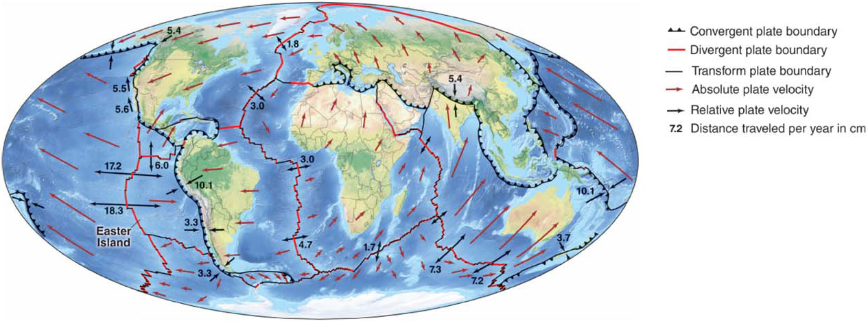
How Fast Do the Plates Move?
Two kinds of plate velocity can be measured: relative and absolute. Relative plate velocity is the speed of a plate in relation to the speed of another plate, and absolute plate velocity is the speed of a plate in relation to a fixed object, such as the center of Earth.
Imagine riding your bike at 10 km/h (6 mph) past someone who is standing still on the sidewalk. Your speed, to that person, is 10 km/h. That is your absolute velocity. If another bicyclist passes you traveling 12 km/h (7.5 mph), that rider’s absolute velocity is 12 km/h (to the person standing on the sidewalk). But from your perspective on your bicycle, that rider is traveling only 2 km/h. Two kilometers per hour is that rider’s relative velocity.
Similarly, if two lithospheric plates each have an absolute velocity of 5 cm (2 in) per year, and they are both moving away from each other, their relative velocity is 10 cm (4 in). If they are traveling in the same direction, however, their relative velocity is 0 cm per year, because they are both moving in the same direction at the same speed, like two bicyclists traveling at the same speed together.
Today, plate movement can be measured with millimeter-
Why Is the Theory of Plate Tectonics Important?
Plate tectonics is one of the most important scientific theories developed in the twentieth century because it explains such a wide range of geophysical phenomena. Plate tectonics is called a unifying theory because it gathers together seemingly unrelated phenomena and puts them together under the same umbrella of explanation. The formation and geographic locations of volcanoes, earthquake patterns, rock types and ages, island formation, lake formation, undersea mountain ranges, deep-