10.1 The Physical Oceans
Discern the major physical features of the oceans.
Physical geography explores all of Earth’s physical systems. The oceans are a particularly important realm of physical geography. Consider these facts:
Question 10.1
How deep are the oceans?
The oceans are 4 km (2.5 mi) deep on average and nearly 11 km (7 mi) at their deepest.
The oceans are large and deep. They cover 71% of Earth’s surface, and they are 4 km (2.5 mi) deep, on average. If Earth’s surface were a smooth sphere without valleys or mountains, seawater would cover the planet to a depth of 2,500 m (8,200 ft). Table 10.1 provides some key statistics on the oceans.
Table : TABLE 10.1 Physical Characteristics of the OceansCHARACTERISTIC
SIZE (METRIC)
SIZE (U.S. CUSTOMARY)
Total area
331,441,932 km2
127,970,392 mi2
Total volume
1,303,155,354 km3
312,643,596 mi3
Average depth
4 km
2.5 mi
Greatest depth
10,916 m
35,814 ft
Longest mountain range
16,000 km
9,920 mi
Because of their size, the oceans regulate the atmosphere’s chemical composition and modify Earth’s climate and weather systems.
Seventy percent of the oxygen in the atmosphere comes from photosynthesis in the oceans.
There would be no life on Earth without the oceans.
Nearly half the world’s population depends directly on the oceans as a main source of food.
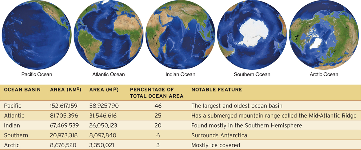
The Five Oceans
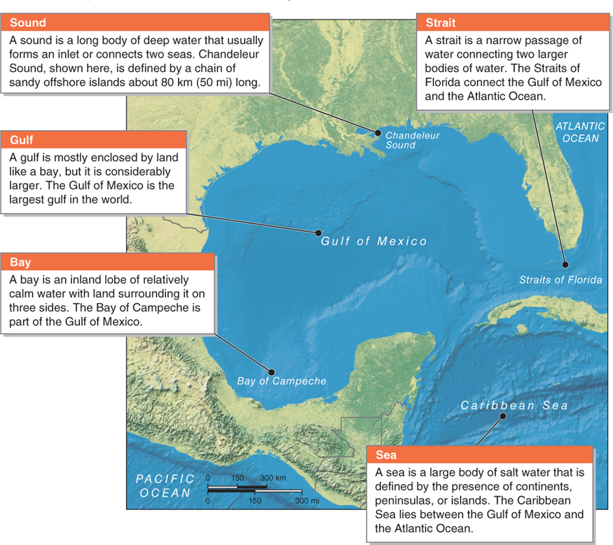
The terms sea, gulf, bay, sound, and strait are used in reference to large bodies of salt water. Figure 10.2 provides an example of each of these water bodies using the Gulf of Mexico region.
The term ocean is used to refer to the five major water-
Layers of the Ocean
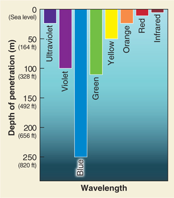
Only the ocean’s surface layers absorb light and are heated directly by sunlight. The depth to which light can penetrate seawater depends on the time of day, the weather above the sea surface, and water clarity. In murky water containing suspended sediments, light barely penetrates 10 m (33 ft). Different wavelengths of light penetrate seawater to different depths. As Figure 10.4 shows, blue wavelengths of light penetrate deepest.
The ocean’s surface temperatures vary considerably with latitude. Because of the direct sunlight in the tropics and the largely cloud-
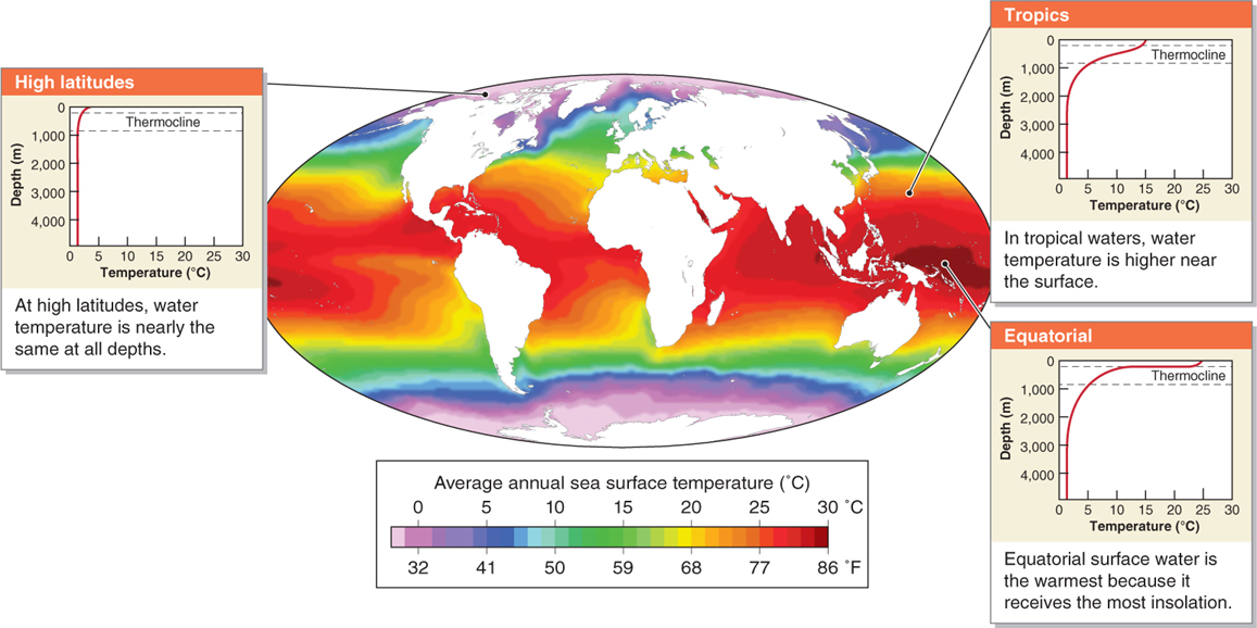
In the tropics, starting at a depth of about 100 m (330 ft), the water temperature quickly declines with depth until about 500 to 1,000 m (1,640 to 3,300 ft). This transitional zone of temperature decline is called the thermocline. The depth of the thermocline varies by latitude and by ocean (see Figure 10.5). Below 2,500 m at all latitudes, seawater temperatures stabilize to a uniform 2°C (35.6°F).
thermocline
The transitional zone between warm surface waterand cold water at depth.
The oceans can be divided into five vertical layers or zones (Figure 10.6). These layers are distinguished by light penetration, water temperature, and seafloor features. The topmost layer, called the epipelagic zone, is the sunlit surface of the ocean. It extends down to 200 m (650 ft).
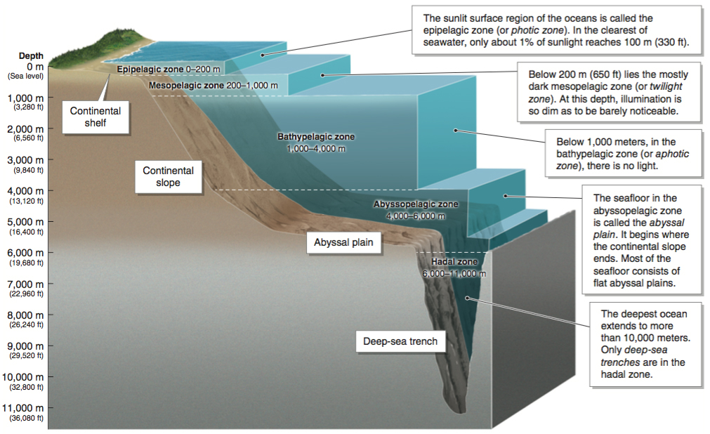
epipelagic zone
The sunlit surface of the ocean down to 200 m (650 ft).
Water Pressure
At the ocean’s surface, there is no water pressure. Yet if you were to dive down to 10 m (33 ft), you would experience 1 kg/cm2 (14.7 psi) of pressure. For every 10 m in depth, water pressure increases approximately one bar (or one atmosphere), which is 1 kg/cm2 (see Section 1.2). The enormous pressures in the deep ocean create a formidable barrier to scientists attempting to explore life there. Crunch the Numbers shows how water pressure is calculated.
CRUNCH THE NUMBERS: Water Pressure in the Deep Ocean
CRUNCH THE NUMBERS: Water Pressure in the Deep Ocean
Calculate water pressure in the deep ocean in kilograms per square centimeter or pounds per square inch.
Step 1: Calculate the number of bars by dividing the depth by 10 m (or 33 ft if you are working in U.S. customary units).
Step 2: Calculate kg/cm2 by multiplying the number of bars by 1 (or by 14.7 to get psi).
Problem 1
Question 10.2
Sperm whales dive to 2,000 m (6,580 ft) as they hunt giant squid. They have collapsible rib cages and lungs that allow them to withstand the great pressure at that depth. What is that pressure?
Problem 2
Question 10.3
The Challenger Deep, in the Mariana Trench, is the deepest point in the ocean at 10,916 m (35,814 ft). What is the pressure at that depth?
Seawater Chemistry
Salinity
Leonardo da Vinci thought that the oceans were salty because rivers ran past salt mines and deposited the salt in the oceans. His hypothesis was not too far off the mark. Rivers do deposit salt and many other minerals in the oceans, but not because they run past salt mines.
Salinity is the concentration of dissolved minerals in seawater. As rivers flow over the continents, they dissolve minerals from the rocks and transport those dissolved minerals to the ocean. Each year, rivers deposit about 2.5 billion tons of dissolved minerals, including salt, in the oceans. The salinity of the oceans remains constant, however, because shell-
salinity
The concentration of dissolved minerals in seawater.
Question 10.4
Why are the oceans salty?
The oceans are salty because rivers carrying dissolved minerals, including salt, empty into them.
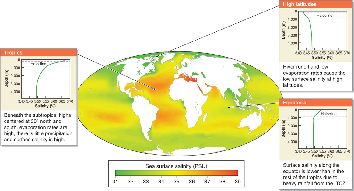
The average ocean salinity is 3.5% by volume (35 g/L or 4.6 oz/gal). Ocean salinity varies geographically from about 1% to 4.1% (Figure 10.7). There are two main reasons for this geographic variation: (1) salinity increases where evaporation is high, and (2) salinity decreases where rivers discharge their freshwater or where there are persistent heavy rains.
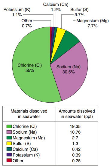
By volume, most of the material dissolved in ocean water is chlorine and sodium, but every element on Earth is found dissolved in ocean water in trace amounts (Figure 10.8). When sodium is combined with chloride, the result is sodium chloride (NaCl), or salt.
Ocean Acidity
The oceans play an important part in the short-
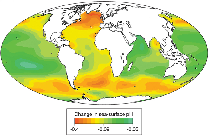
The chemistry of this ocean acidification is well understood. However, scientists are less certain how it will affect marine organisms in the coming decades. They are concerned that shell-
Many scientists are concerned that the current rate of ocean acidification is faster than what has occurred naturally at any time during the last 300 million years. Past ocean acidification has been linked to global mass extinctions of shell-
Surface Ocean Currents
The atmosphere and the oceans are both fluids. Therefore, they flow, as wind in the atmosphere and as currents in the oceans. There are two kinds of ocean currents: (1) surface ocean currents driven by wind and (2) deep ocean currents driven by differences in water density (see Section 6.2). Surface ocean currents and deep ocean currents both redistribute heat energy across Earth’s surface.
If you have ever blown air over a hot cup of coffee or tea, you may have noticed that the force of moving air pushes the surface to the far side of the cup. On a hemispheric scale, the wind blows across the surface of the oceans, and the friction between the air and the water’s surface sets the water in motion, forming surface ocean currents. As we saw in Section 4.2, Coriolis force deflects wind to the right in the Northern Hemisphere and to the left in the Southern Hemisphere, creating anticyclonic systems. It deflects moving water in the same way, creating large circular ocean currents called gyres (Figure 10.10).
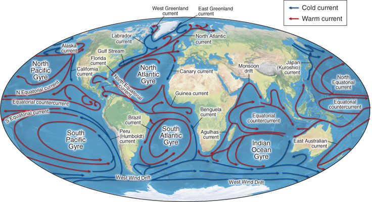

gyre
A large, circular ocean current.
 One notable result of ocean gyres is that they corral plastic and other trash in the oceans, concentrating it into vast garbage patches. The Geographic Perspectives at the end of this chapter explores this problem further.
Seafloor Topography
Imagine completely drying up the oceans. What would the exposed seafloor look like? The features of the seafloor include major mountain ranges, extensive plains, and deep trench systems (Figure 10.11). The measurement of depth and topographic features beneath the surface of a body of water is called bathymetry (see also Figure 10.6).
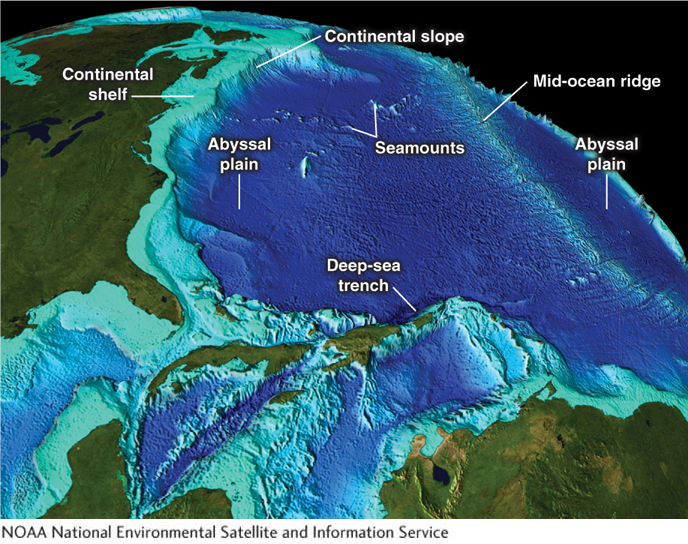
bathymetry
Measurement of depth and topography beneath the surface of a body of water.
If the oceans were dried up, you would see continental shelves (the shallow, gently sloping areas of seafloor near continental margins). You would see steeper continental slopes forming the transition between the continental shelves and the endless flat stretches of the deep seafloor. The abyssal plains are large flat areas on the ocean floor at depths between 4,000 and 6,000 m (13,000 and 20,000 ft).
continental shelf
The shallow, sloping seafloor near continental margins.
abyssal plain
A flat plain on the ocean floor at depths between 4,000 and 6,000 m (13,000 and 20,000 ft).
From these plains rise the world’s longest mountain ranges, called mid-
mid-ocean ridge
A submarine mountain range.
seamount
A mountain rising from the seafloor, often a flat-
deep-sea trench
A long narrow valley on the seafloor; deep-
deep-sea trenches
Long narrow valleys on the seafloor; deep-