12.3 Plate Boundary Landforms
Describe the three types of plate boundaries and the landforms resulting from each plate boundary type.
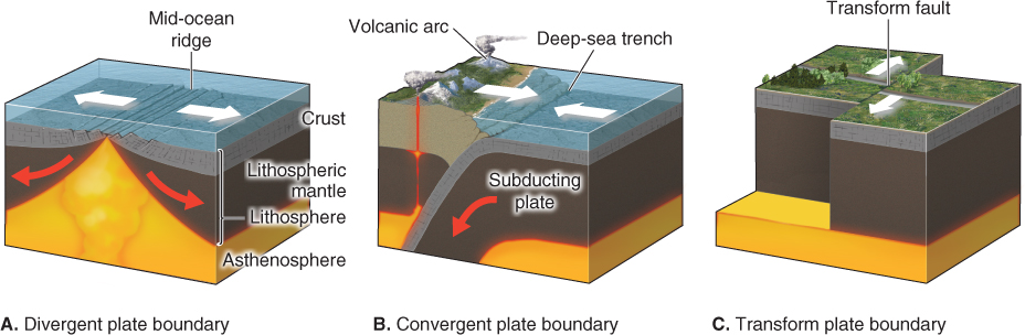
Most deformation of Earth’s crust occurs at the margins of the lithospheric plates. The extent of deformation, and the resulting landforms, depend on the way the plates move in relation to one another. There are three types of plate boundaries: divergent plate boundaries, convergent plate boundaries, and transform plate boundaries (Figure 12.11). A divergent plate boundary occurs where two plates move apart. A convergent plate boundary occurs where two plates move toward each other. A transform plate boundary occurs where one plate slips laterally past another.
divergent plate boundary
A region where two lithospheric plates move apart.
convergent plate boundary
A region where two lithospheric plates move toward each other.
transform plate boundary
A plate boundary where one lithospheric plate slips laterally past another.
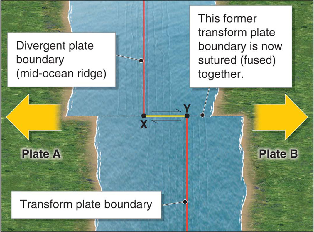
Divergent Plate Boundaries
Mid-
Although they are hidden beneath the ocean, mid-
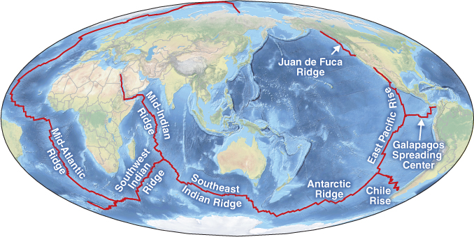
Along the mid-
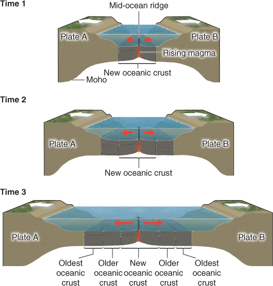
Magma has a lower density, and is thus more buoyant, than the solid rock of the crust that surrounds it. As a result, magma rises upward. It may cool beneath the crust’s surface. If it is extruded (pushed out) onto the seafloor, however, it forms submarine volcanoes.
This rising magma, and its formation of new oceanic crust, creates the ridge push that moves the plates at the mid-
 Animation
Seafloor spreading
Rifting
A rift is a region where continental crust is stretching and splitting. At a rift, two portions of the crust are moving apart, as they do at a mid-
rift
A region where continental crust is stretching and splitting.
rift valley
A linear valley with volcanoes formed by rifting of continental crust, sometimes filled with freshwater to form a deep lake.
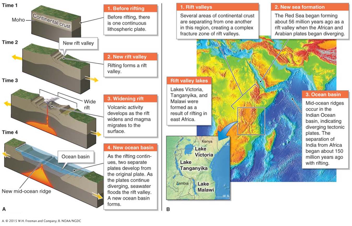
Lake Tanganyika, in the East African Rift system (Figure 12.14B), is 1,470 m (4,820 ft) deep. Because of its great depth, it is the world’s second largest lake by volume of water (not by surface area). Lake Malawi is 706 m (2,316 ft) deep and is the world’s sixth largest lake by volume. Also on the East African Rift system, Lake Victoria is the second largest lake in the world by surface area (68,800 km2 or 26,600 mi2).
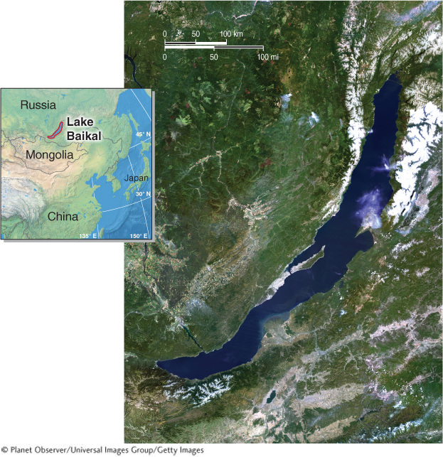
The world’s largest lake by volume is Lake Baikal, in Russia. It is 1,642 m (5,387 ft) deep and contains 20% of Earth’s surface freshwater. It is thought to be the oldest lake in the world (at 25 million years old). It, too, is a result of rifting (Figure 12.15).
Convergent Plate Boundaries
Subduction
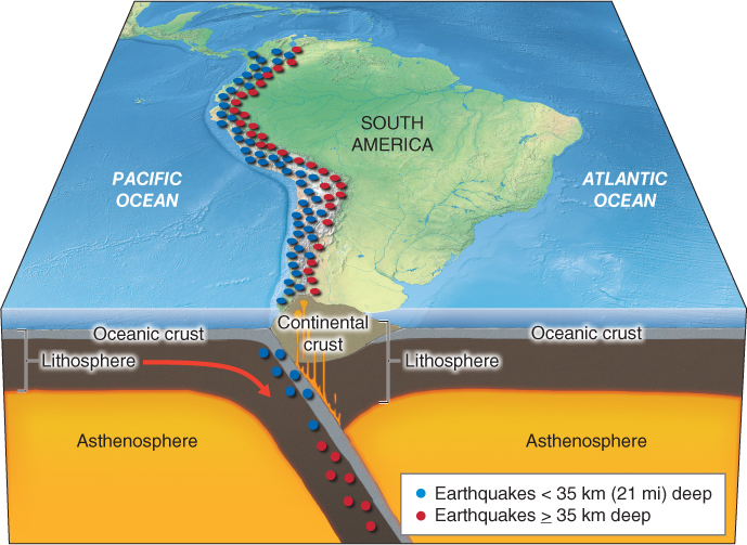
We live on a planet with many natural hazards. Certainly among the most deadly of those natural hazards are the powerful and explosive volcanoes that form along convergent plate boundaries where subduction is occurring (see Figure 12.11B). The presence of a deep-
As the plates grind against each other during subduction, they generate earthquakes, some of which are very powerful. An earthquake is caused when two plates are stuck together, then suddenly become unstuck, releasing energy that radiates out as seismic waves (see Section 14.3). The locations of these earthquakes follow the profile of the subducting plate. Thus, subduction zones produce a sloping pattern of increasingly deep earthquake foci (or centers) called a Wadati-
Wadati-Benioff zone
A sloping pattern of increasingly deep earthquake foci found in a subduction zone.
Oceanic lithosphere is consumed and recycled in the process of subduction. This process occurs at the same rate that new oceanic crust is formed at mid-
Continental lithosphere, on the other hand, is not subducted because it is less dense than oceanic lithosphere and thus too buoyant. This property has kept the continents free of subduction for most of Earth’s history. Therefore, the oldest and most tectonically stable portions of the lithosphere are found in continental areas called shields.
Shields form the stable nucleus of a continent. The crust of the continental shields is at least 570 million years old. The oldest shield is the Canadian Shield, which is estimated to have formed about 4 billion years ago, just after early Earth’s surface cooled from a molten state (see Section 11.1).
Types of Subduction
When oceanic lithosphere is subducted beneath continental lithosphere, extensive regions of volcanic activity result. The subducting oceanic lithosphere brings large amounts of seawater with it into the lithospheric mantle. Water lowers the melting point of the mantle, and as a result, portions of the oceanic crust and the mantle melt into magma.
Because magma is less dense and more buoyant than the surrounding solid rock, it rises up, melting its way through the margin of the continental crust. As it does so, it incorporates continental crust material in a process called partial melting. The pressure exerted by the surrounding rock also squeezes the magma up to the surface. This process forms a continental volcanic arc: a long chain of volcanoes on the margin of a continent above a subducting plate (Figure 12.17).
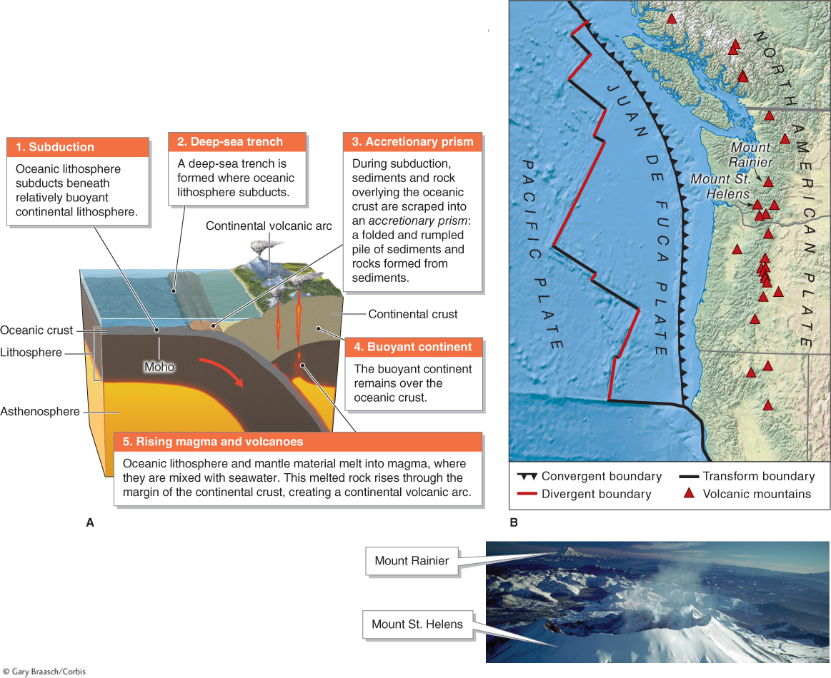
continental volcanic arc
A long chain of volcanoes formed on the margin of a continent above a subducting plate.
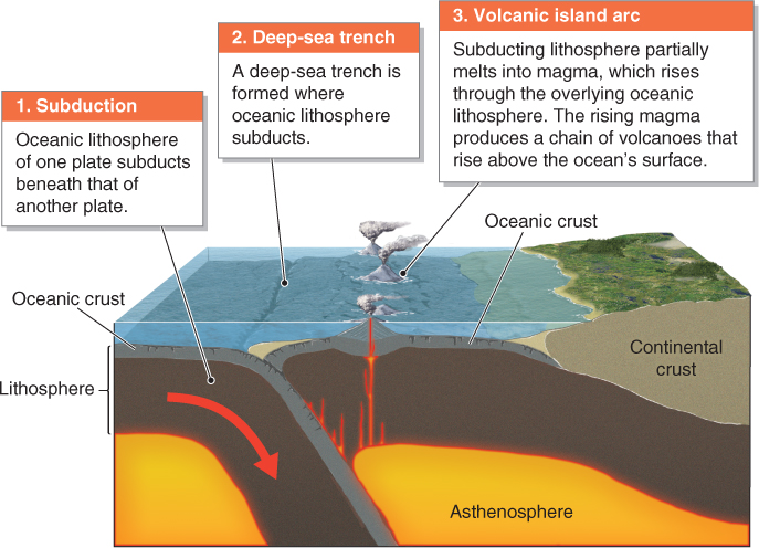
Subduction can also occur where the oceanic lithosphere of two separate plates converges. In this case, a similar sequence of events occurs: Oceanic lithosphere of one plate subducts beneath that of another plate, resulting in a chain of volcanoes. The difference, however, is that the region of subduction is submerged beneath the ocean, and the volcanoes form on the seafloor, where they may eventually rise above sea level to form islands. A volcanic island arc is a chain of islands formed where oceanic lithosphere of one plate is subducting beneath that of another plate (Figure 12.18). Examples of volcanic island arcs include Tonga, the western Aleutian Islands of Alaska, northeastern Japan, East Timor, the Philippines, and most of Indonesia.
volcanic island arc
A chain of islands formed where oceanic lithosphere of one plate is subducting beneath oceanic lithosphere of another plate.
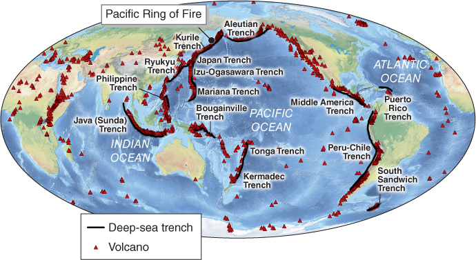
Extensive chains of volcanoes, formed through both types of subduction, occur around the perimeter of the Pacific Ocean, from Chile to Mexico to California, north to Alaska, and south again to Japan, the Philippines, and Indonesia, all the way to Antarctica. Collectively, these volcanic mountain ranges make up the Pacific Ring of Fire: a zone of volcanically active mountain chains resulting from subduction on the margins of the Pacific Ocean (Figure 12.19).
Pacific Ring of Fire
A zone of volcanically active mountain chains resulting from subduction on the margins of the Pacific Ocean.
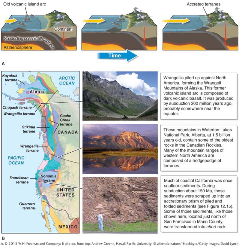
accreted terrane
A mass of crust that is transported by plate movement and fused onto the margin of a continent.
Collision
Eventually, if subduction continues, two continents will come together because oceanic crust is completely subducted and the following continent collides at the plate boundary. Collision occurs where the continental crust of two different plates converges. Because continental crust does not subduct, collision results in the formation of a mountain belt as the crust is heaved upward. As illustrated in Figure 12.20, collision can follow after the closing of an ocean basin.
collision
Convergence of the continental crust of two different plates.
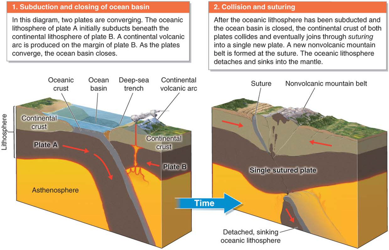
Collision results in a jumble of rocks that have been crushed, broken, folded, and chemically transformed by the enormous heat and pressure it generates. Nonvolcanic mountains form where the crust is thickened and buckled by collision.
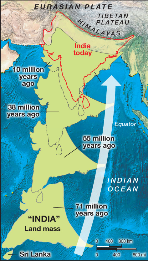
Collision sutures plates together. The Appalachian Mountains in the eastern United States were formed 280 million years ago as the continental crust of two different plates collided and fused to form the North American plate. The Himalayas are still being formed by collision between the Indo- This collision has created the world’s highest plateau and mountain range. The Geographic Perspectives section at the end of this chapter explores the role this region plays in providing water and food for people. Eventually, the Indo-
Accreted Terranes
Why do some continents have a mosaic of mismatched crust types along their margins? An accreted terrane is a mass of crust that is transported by plate movement and fused onto the margin of a continent. Accreted terranes result from a combination of subduction of oceanic lithosphere and collision of landmasses that are smaller than continents. Terranes can travel thousands of miles across ocean basins before they encounter a continent. (Note that terrane refers to a piece of land added to continental crust, while terrain refers to the topography of a landscape.)
India is not considered an accreted terrane because the Indian landmass before it joined to Eurasia was considered a whole continent. However, as the Indo-
Accreted terranes are found worldwide, but the largest accreted terrane group is in western North America. From Alaska to Mexico, terranes that have traveled across the Pacific Ocean basin have piled up on the western edge of the North American continent. As Figure 12.22 shows, these terranes have significantly increased the size of the continent.
Scientists can use their knowledge of plate movements to predict that certain landmasses that are currently isolated in the ocean will eventually become part of a continent. Picture This features the Seychelles, in the western Indian Ocean, as an example of a terrane that will one day join a continent.
Transform Plate Boundaries
Where two plates slip laterally past each other, a transform plate boundary is created (see Figure 12.11C). At transform plate boundaries, the crust is being sheared and torn, but no new crust is formed, and no old crust is recycled into the mantle. No mountains are built, and there are no volcanic eruptions.
Transform plate boundaries are most common on the seafloor at mid-
Animation
Transform Fault
Picture This
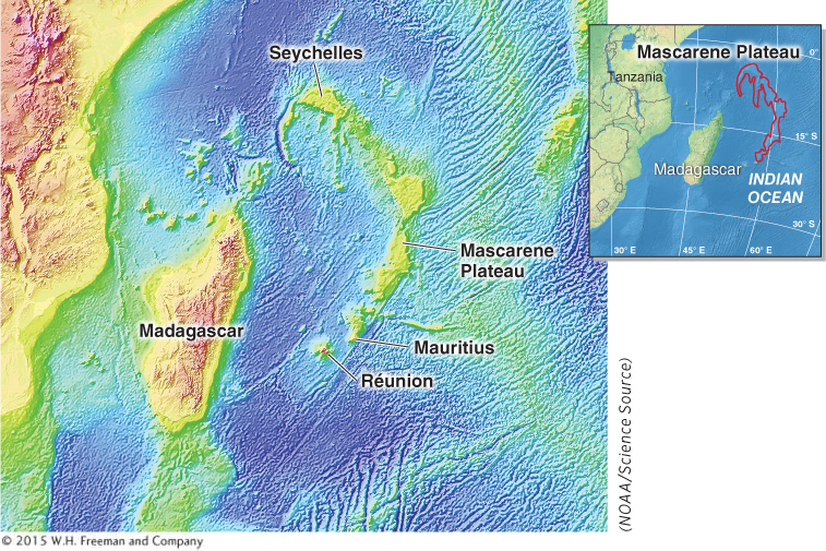
The Mascarene Plateau
The Seychelles, a chain of islands in the western Indian Ocean, form an independent country about 1,300 km (800 mi) east of mainland Africa. The Seychelles are part of the larger archipelago of 115 islands that sit on the Mascarene Plateau. The northern portion of the Mascarene Plateau, where the Seychelles are located, is composed of buoyant granitic continental crust. The southern portion is composed of volcanic rock, and the island of Réunion, found at the southern end of the plateau, is volcanically active. The island of Mauritius, near Réunion, is an extinct volcano.
The granitic crust of the Seychelles was last attached to India 65 million years ago. The islands lie on a piece of the Indo-
Consider This
Question 12.1
What kinds of evidence do you think would be necessary to support the theory that the northern Mascarene Plateau was once attached to India?
Question 12.2
Why will the granitic portions of the Mascarene Plateau and the Seychelles never subduct into the mantle?
CRUNCH THE NUMBERS: Calculating Rate of Plate Movement
CRUNCH THE NUMBERS: Calculating Rate of Plate Movement
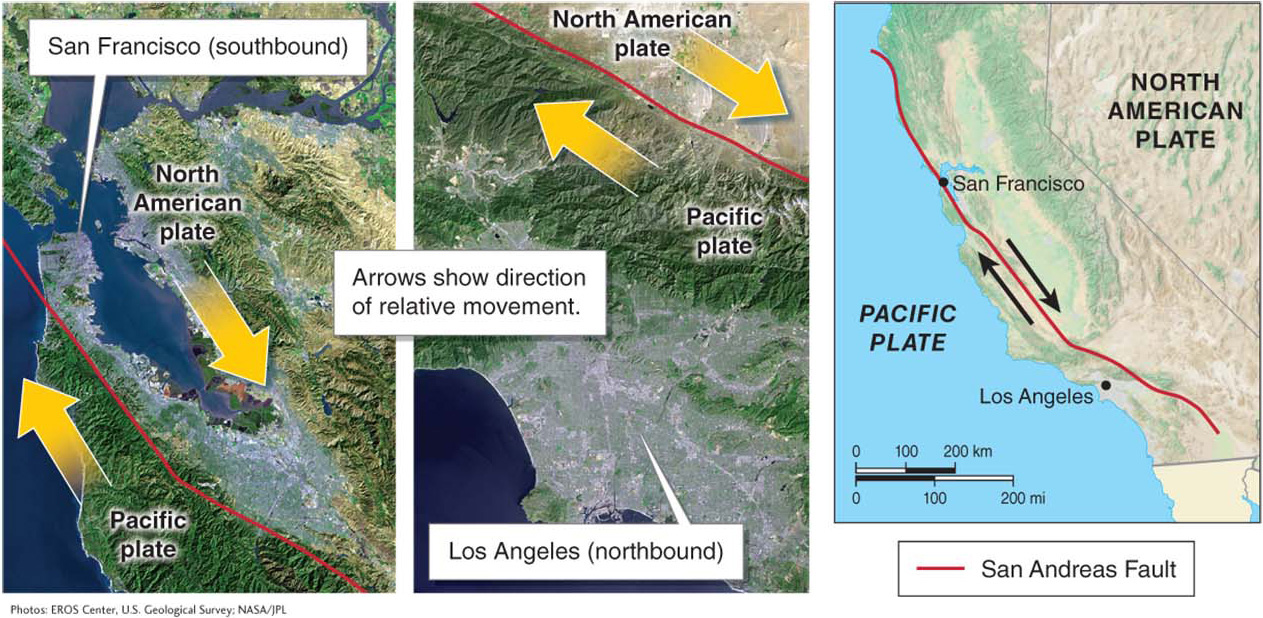
Is it true that Los Angeles will someday be connected to San Francisco?
These two cities, which lie on opposite sides of a transform plate boundary, will be brought together by plate movement millions of years in the future.
Los Angeles sits on the Pacific plate, and San Francisco sits on the North American plate. These two lithospheric plates are slipping past one another along a transform plate boundary, so that Los Angeles is moving north toward San Francisco. The relative velocity of the two plates is 5 cm (2 in) per year. Los Angeles and San Francisco are 880 km (550 mi) apart. Calculate how long it will take for Los Angeles to meet San Francisco.
There are 100,000 centimeters in a kilometer (63,360 inches in a mile).
Question 12.3
Step 1: Convert kilometers to centimeters by multiplying by 100,000 (or miles to inches by multiplying by 63,360).
Question 12.4
Step 2: Divide the distance between the two cities by the rate of movement per year. Make sure your distance and rate of movement are in the same units.
Crunch the Numbers takes a mathematical approach to gauging the rate of movement of crust along this transform plate boundary.
Active and Passive Continental Margins
Notice in Figure 12.7 that only some plate boundaries follow the outlines of continents. Geographers distinguish between active continental margins and passive continental margins (Figure 12.24). An active continental margin is a plate boundary; in many cases, it consists of a deep-
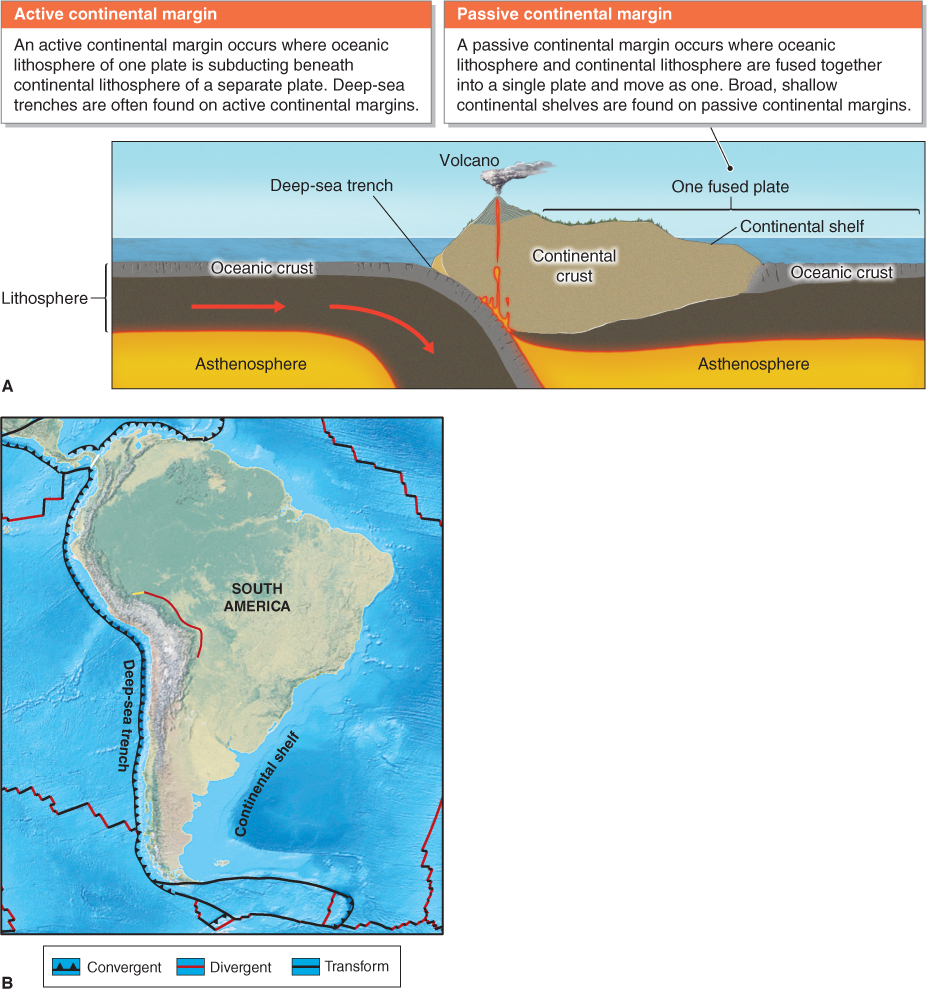
active continental margin
A margin of a continent that follows a plate boundary, typically characterized by a deep-
passive continental margin
A margin of a continent that does not coincide with a plate boundary, typically characterized by a broad, sloping continental shelf.