16.2 Downcutting by Streams: Fluvial Erosion
Explain how streams evolve through time as they erode Earth’s surface.
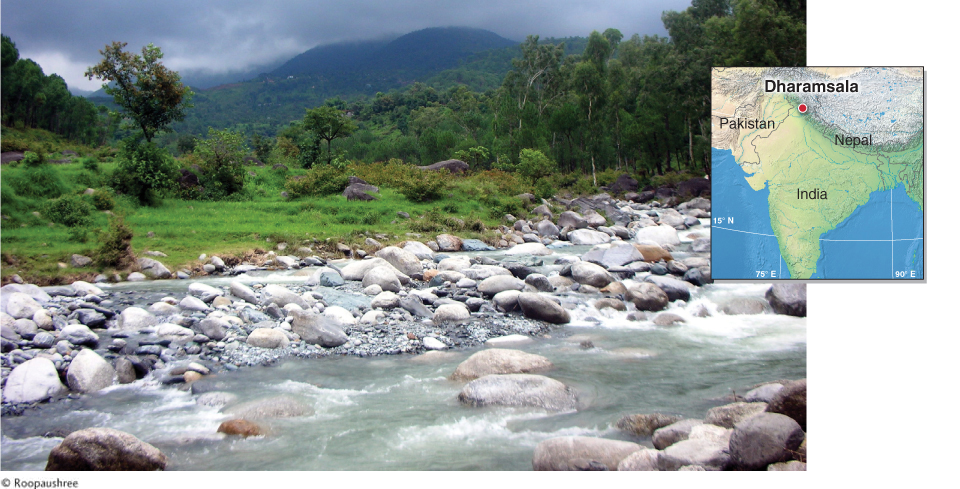
Flowing water is the most important and widespread agent of erosion on Earth. Without the Sun’s energy, fluvial erosion would not exist. As we have seen, the Sun provides heat energy to evaporate water and lift it into the atmosphere. The force of gravity is important as well: Water that condenses in the atmosphere falls to Earth as precipitation, and Earth’s gravitational field pulls that water downslope. The kinetic energy of the stream’s flowing water works to cut downward into Earth’s surface (a process called downcutting) and transport rock fragments downslope toward the oceans.
As water flows back to the oceans, it forms stream channels. The force of water tumbles rocks in the channel and breaks them apart physically. At the same time, chemical weathering dissolves minerals in the rocks. Streams transport this broken and dissolved material downstream in the process of fluvial erosion (erosion by running water; from the Latin word fluvius, which means “river”).
fluvial erosion
Erosion by running water.
Fluvial erosion begins as rain falls on the ground. Some of the rainwater flows into and through the ground, where it contributes to soil moisture and groundwater. Where the ground surface is sloped, rainwater flows downslope in thin sheets called sheet wash.
As rainwater collects in low-
As the amount of water and the speed of flow in a stream channel increase, the stream gains more energy to do the work of carrying soil particles and rock fragments downslope. Figure 16.10 illustrates the process of headward erosion, by which a stream channel lengthens upslope through time, forming new rills and gullies by fluvial erosion. The spatial scale of headward erosion ranges from a few meters to hundreds of kilometers or more, and its time scale varies from weeks to thousands of years or longer, depending on the geographic setting, geology, and climate.
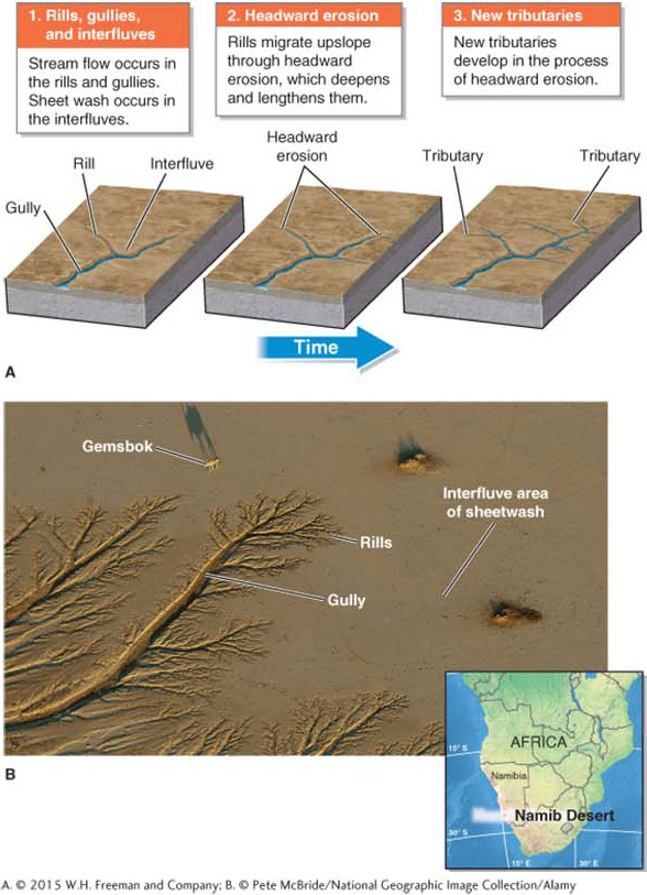

headward erosion
The process by which a stream channel migrates upslope by forming new rills through fluvial erosion.
The Volume of Water: Stream Discharge
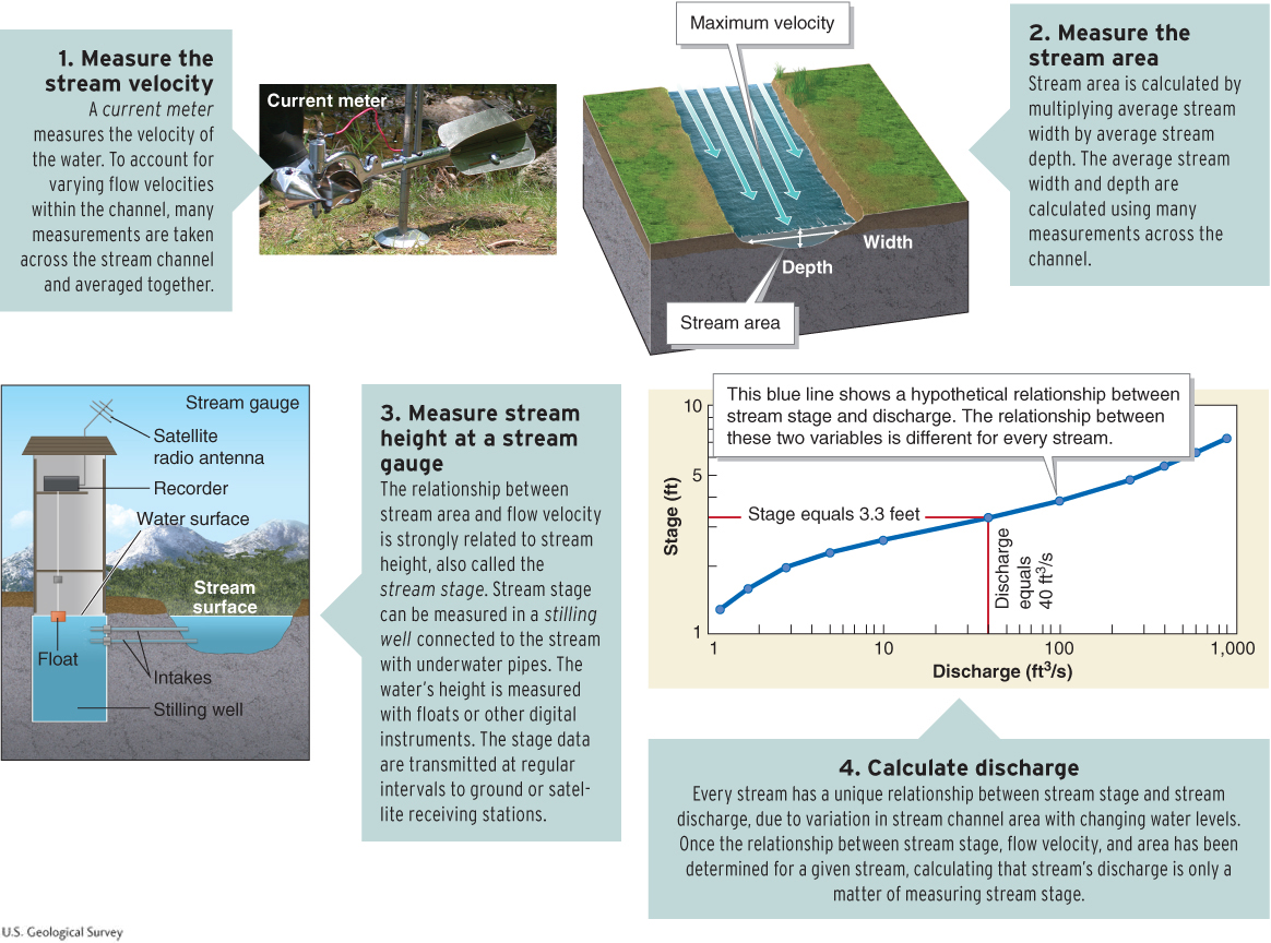
Stream discharge is the volume of water flowing past a fixed point within a stream channel. It is expressed in cubic meters per second (m3/s) or cubic feet per second (ft3/s). Discharge can be visualized as the number of 1 m (or 1 ft) cubes passing beneath a bridge every second. Discharge is often recorded on a stream hydrograph (see Figure 16.11).
stream discharge
The volume of water flowing past a fixed point within a stream channel; expressed in cubic meters or cubic feet per second.
Discharge is important because the more water is flowing through a stream channel, and the faster that water is flowing, the more energy the stream has to erode Earth’s surface. The discharge of a stream is influenced mainly by climate, stream order, season, and surface permeability (Table 16.1).
|
1. Climate: Streams in wet regions have greater discharge than streams in arid regions. |
|
2. Stream order: First- |
|
3. Season: Streams experience peak flow periods that depend on the timing of precipitation or snowmelt. Heavy rainfall can increase stream discharge by several hundred times. |
|
4. Surface permeability: Permeable soil and rock allow water to infiltrate the ground rather than flow over it in a stream channel. Greater permeability reduces surface stream discharge. |
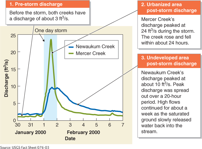
Urbanization changes the permeability of the ground surface and therefore the discharge of streams. Paved surfaces are impermeable, and water flows from them quickly into nearby streams, rather than infiltrating the ground. As a result, streams in urbanized areas experience sudden spikes in discharge during heavy precipitation events, and discharge drops quickly after storms. Figure 16.11 compares the discharge of an urbanized stream with that of a stream in a rural location.
In calculations, stream discharge is symbolized by Q. Discharge is measured by multiplying the stream channel area (A) by the speed of water flow, or velocity (v): Q = A · v. Stream channel area is calculated by multiplying channel width by channel depth. The calculation of stream discharge takes into account the variations in flow velocity, stream channel area, and river height that are unique to each stream (Figure 16.12).
The Amazon River has the highest average discharge in the world, about 200,000 m3/s, or 7 million ft3/s. The Amazon’s flow constitutes nearly 20% of the world’s total discharge by rivers into the oceans. Crunch the Numbers compares the flow of North America’s largest river (in terms of discharge), the Mississippi River, with that of the Amazon River.
CRUNCH THE NUMBERS: Calculating Stream Discharge
CRUNCH THE NUMBERS: Calculating Stream Discharge
Using the discharge equation Q = A · v, calculate the average discharge for the Amazon River and the Mississippi River. Give your answer in cubic meters per second.
Question 16.5
Problem 1: At a given location, the Mississippi River is 1,670 m wide and an average of 12 m deep, with an average flow velocity of 0.91 m/s. What is the discharge for the Mississippi River at that location?
Question 16.6
Problem 2: At a given location, the Amazon River is 15,200 m wide and an average of 15 m deep, with an average flow velocity of 1 m/s. What is the discharge for the Amazon River at that location?
Question 16.7
Problem 3: Approximately how many Mississippi Rivers would fit into the Amazon River? To calculate this answer, divide the Amazon discharge by the Mississippi discharge.
The Work of Water: Stream Load
The force of flowing water, called hydraulic action, frees rock fragments and sets them in motion. The size of those fragments may range from tiny grains of sand and silt to large boulders.
Question 16.8
Why are river rocks rounded?
River rocks are rounded by abrasion. As rocks move in a streambed, they grind against one another and are sanded smooth and round.
Stream abrasion rounds and polishes rocks in a stream. Abrasion is the process by which movement of one material wears away another material. The continual tumbling of rocks in a streambed wears away other rocks and the channel bedrock (Figure 16.13). Heavy rocks and boulders in a stream channel move only with high flows, however, such as those that follow heavy rains or snowmelt.
abrasion
The process by which movement of one material wears away another material.
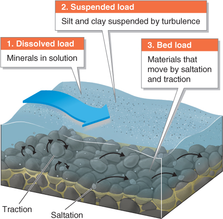
The material that moves within a stream channel is called the stream load. The size of the particles that move within a stream is directly related to stream discharge and flow velocity. There are three kinds of stream loads:
The dissolved load consists of soluble minerals that are carried in solution by a stream.
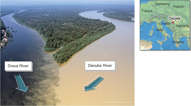
The suspended load consists of small particles of clay and silt that are light enough to remain suspended by turbulence (mixing) in the flowing water. The suspended load gives some streams their muddy appearance (Figure 16.14).
A stream’s bed load is the moving material in a stream channel (ranging from small sand grains to gravel, cobbles, and large boulders) that is too heavy to become suspended in the current. Sand grains are moved along in a bouncing or hopping motion called saltation. Larger rocks are moved by a dragging or tumbling motion called traction. Traction sufficient to move large rocks occurs only during peak flow periods. Figure 16.15 illustrates the three types of stream loads.
dissolved load
Soluble minerals that are carried in solution by a stream.
suspended load
Small particles such as clay and silt that remain suspended in flowing water or wind.
bed load
Material in a stream channel such as sand, gravel, and rocks that is too heavy to become suspended in the current.
saltation
A bouncing or hopping motion of sediment in moving water (or air).
traction
The dragging and tumbling of large rocks in a stream channel.
Geomorphologists refer to the size of fragments a stream can transport as stream competence. Streams that can transport large fragments, such as boulders, have high stream competence. Stream capacity refers to the total amount of material (of all sizes) that a stream can transport. During periods of peak discharge, when the stream has more kinetic energy, stream capacity and competence increase.
Stream Grading and Stream Gradient
Streams are referred to as graded if sediment transport within the stream equals the rate of sediment input from around the stream. In other words, in a graded stream, the channel is neither accruing nor losing sediments. Along the length of a graded stream, there is a dynamic equilibrium (or balance) between erosion, transportation, and deposition of sediments within the stream channel. A fully graded stream would have a smooth longitudinal profile like the one shown in Figure 16.16. Few streams, however, have such smoothly graded profiles because of the different rock types, geologic activity, and climates within any given drainage basin.
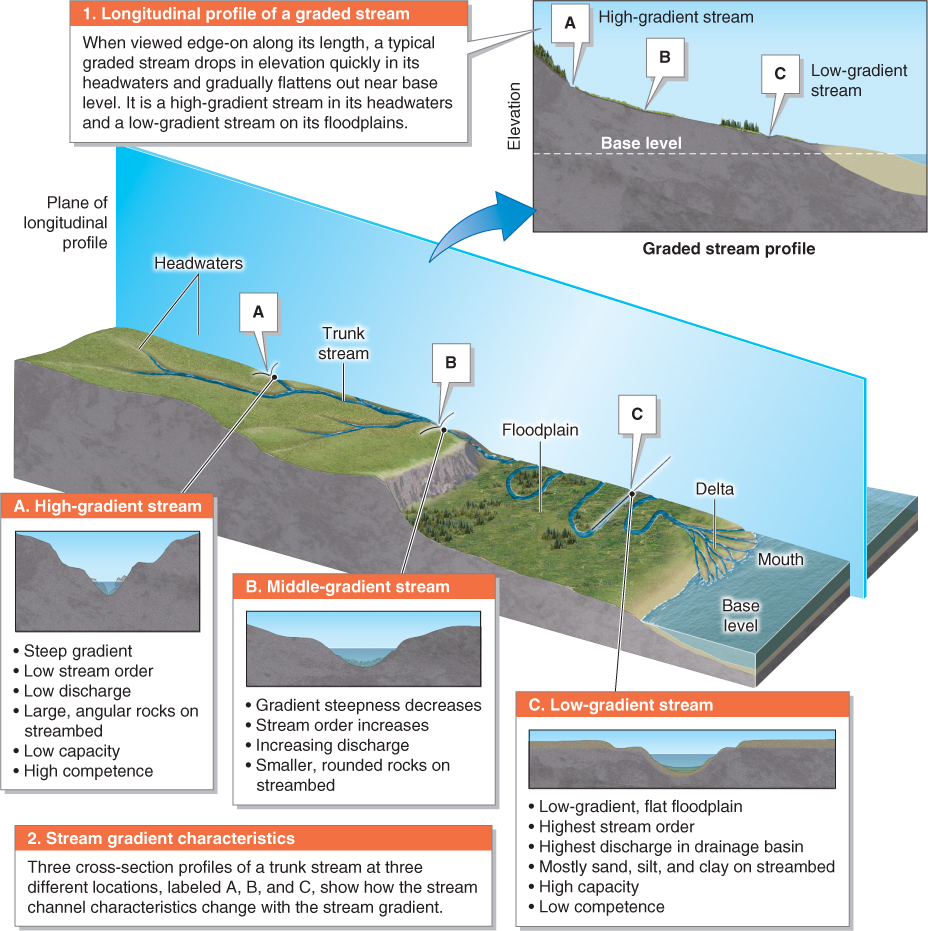
Similarly, stream gradient refers to the drop in elevation of the stream channel in the downstream direction. High-
Carving Valleys and Canyons
Base level is the lowest level a stream can reach, usually sea level. A stream can erode Earth’s surface only where it is above base level. The higher a stream is above base level, the more energy it will have to erode the land surface. At base level, a stream becomes standing water, loses its capacity and competence, and drops the sediments it is carrying.
base level
The lowest level a stream can reach, usually sea level; a stream becomes standing water at base level.
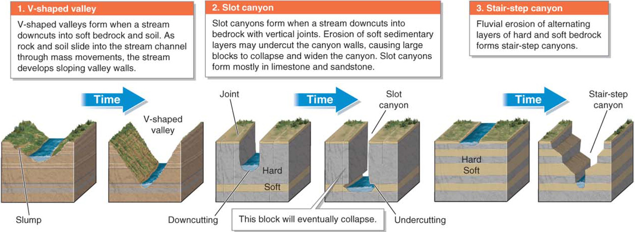
The rate of stream downcutting and the resulting topography depend on the stream’s elevation above base level, stream discharge, flow velocity, and the hardness and structure of the bedrock the stream is cutting through. Harder rocks such as metamorphic rocks are more resistant to downcutting than softer rocks such as sandstone. Most streams cut V-
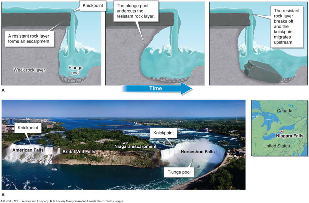
Points of Resistance: Knickpoints
Knickpoints are locations where there is an abrupt increase in stream gradient over a short distance. All waterfalls, for example, form at knickpoints. They often form where a layer of rock that is resistant to erosion overlies a relatively weak and soft layer of rock. The resistant layer of rock creates an escarpment, a long cliff face or steep slope, over which the water flows. As the stream spills over the lip of the resistant rock layer, it may form a bowl at the base of the waterfall, called a plunge pool. Plunge pools are created by abrasion caused by rocks circulating at the base of the waterfall. Eventually, a plunge pool can undercut the support of the resistant layer above, causing it to collapse. As a result, the knickpoint migrates upstream. This process is illustrated in Figure 16.18.
knickpoint
A location where there is an abrupt increase in stream gradient over a short distance.
escarpment
A long cliff face or steep slope.
plunge pool
A bowl at the base of a waterfall created by abrasion from circulating rocks.
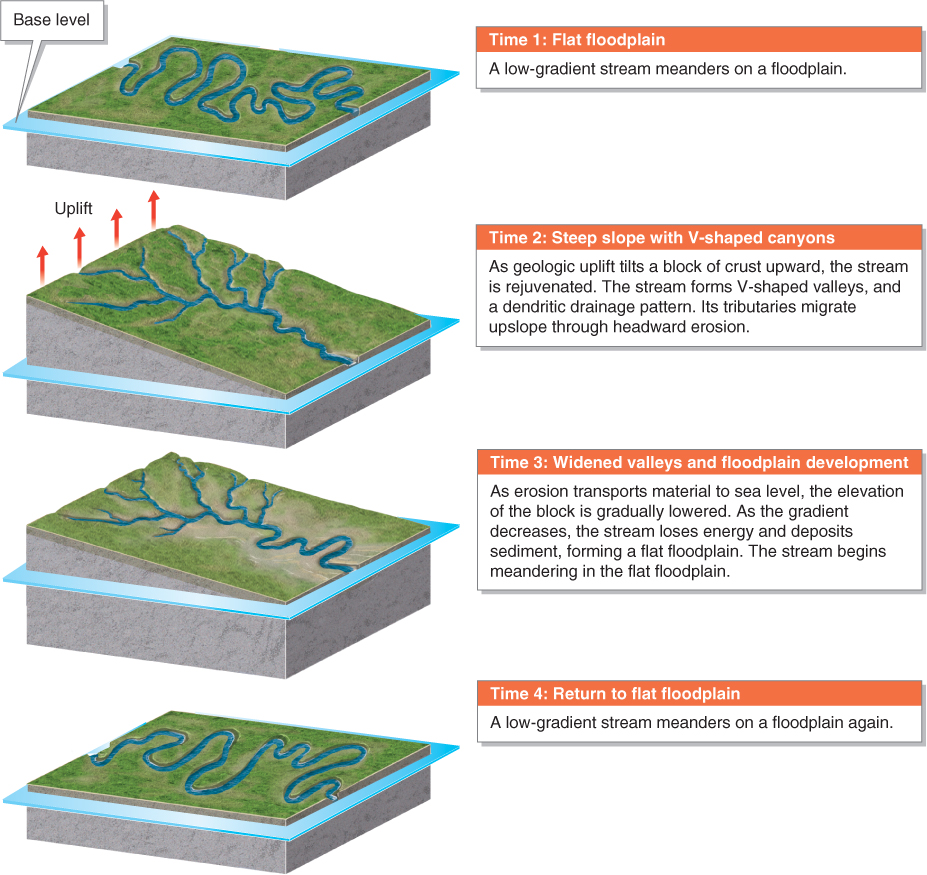
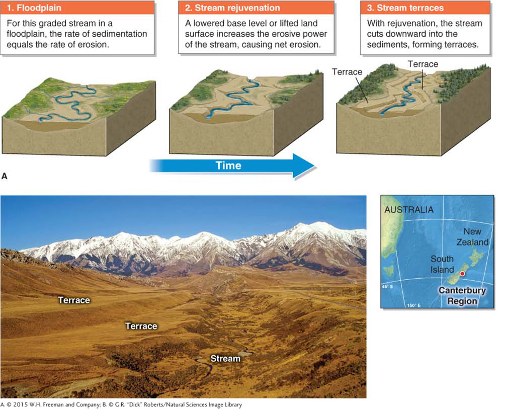
Lifting Streams: Stream Rejuvenation
Stream rejuvenation is a process in which a stream gains downcutting energy as its base level is lowered relative to its drainage basin. Stream rejuvenation is usually a consequence of geologic uplift, but lowered global sea level can also cause stream rejuvenation.
stream rejuvenation
A process by which a stream gains downcutting energy as its base level is lowered relative to its drainage basin.
The higher above its base level a stream lies, the more it will cut into the sediments and bedrock beneath it. Eventually, barring further geologic uplift, the stream will return to its original gradient through weathering, mass wasting, erosion, and deposition (Figure 16.19).
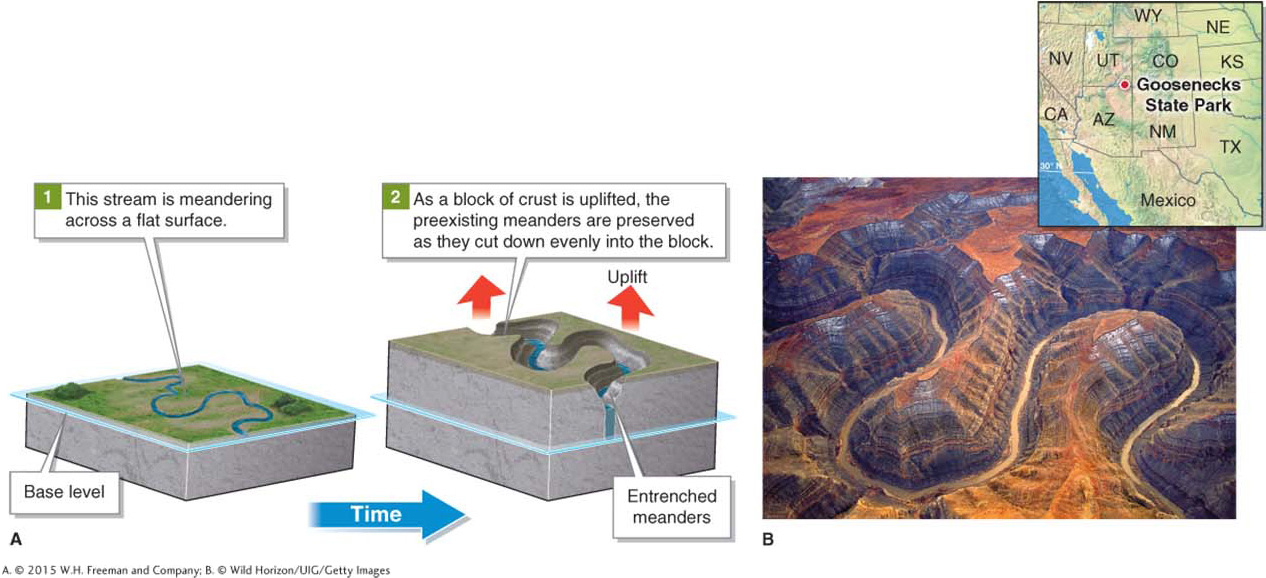
As we will see in Section 16.3, a stream that flows across a flat floodplain may form looping bends called meanders. If geologic uplift creates a level plateau, rather than a slope, stream meanders may be preserved as entrenched meanders as the stream erodes the plateau (Figure 16.20). Entrenched meanders are found throughout the southwestern United States, where geologic uplift raised what was a large, flat floodplain and shallow sea to form today’s Colorado Plateau. The uplift took place gradually and was slightly inclined toward the southwest.
Stream rejuvenation may also result in stream terraces where rivers flow through floodplains. A rejuvenated stream can cut down into the floodplain sediments through headward erosion, creating stepped terraces (Figure 16.21).
Antecedent and Superimposed Streams
Antecedent streams are streams that cut through bedrock ridges rather than flowing around them. Geologic uplift may allow a preexisting stream to cut through resistant ridges of rock as they are slowly lifted. If the rate of uplift and erosion is gradual, the stream can cut into the underlying ridge of bedrock while maintaining its original drainage pattern, resulting in a water gap (Figure 16.22). A water gap is a place where a stream has cut through a resistant ridge of rock.
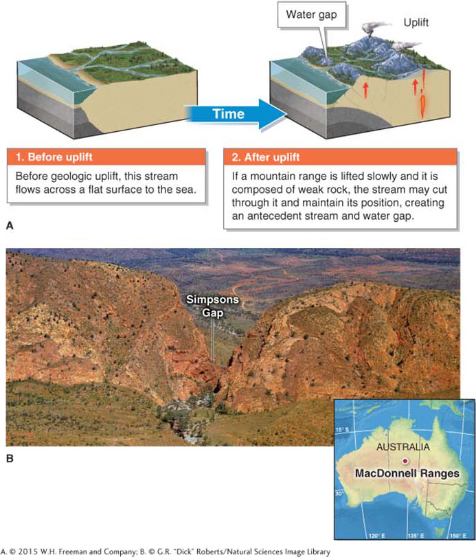
Superimposed streams are like antecedent streams in that they cut through resistant layers of rock and form water gaps. In the case of superimposed streams, however, the land surface is lowered through fluvial erosion rather than being lifted through tectonic forces.
Distinguishing a water gap caused by antecedence from one caused by superimposition is not possible with only a quick glance at the surface. The tectonic and erosional history of a region must be known before determining how the water gap formed. In some cases, streams with water gaps no longer flow in their former channels. When that occurs, a wind gap results.
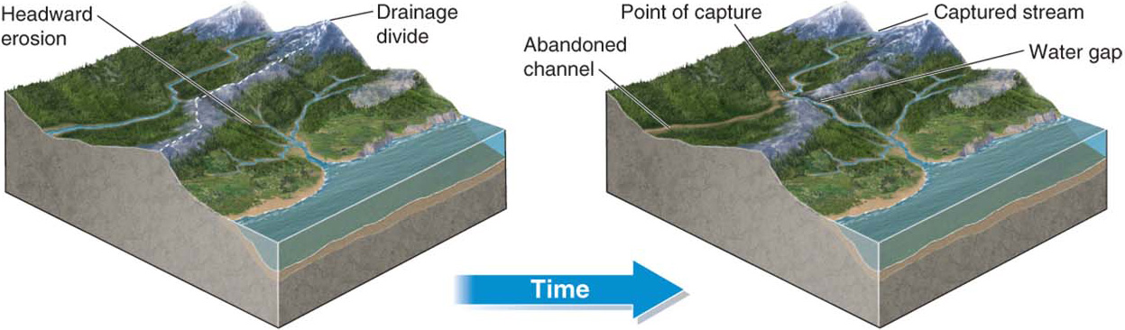
Stream Piracy
Stream piracy is the diversion of one stream into another as headward erosion merges the two streams. When a stream’s tributaries migrate upslope and cut through the drainage divide of another drainage basin, streams within that drainage basin can be diverted into the new stream channel, as illustrated in Figure 16.23.
stream piracy
The diversion of one stream into another as headward erosion merges the two streams.