17.4 Building by Ice: Glacial Deposition
Identify landforms created from glacial sediments and explain how they formed.
Glaciers and streams have many aspects in common. Both are composed of water. Both flow downslope. Both carry sediments. And both deposit sediments where they stop flowing. This section examines landforms made by glacial sediments.
Deposits by Alpine Glaciers
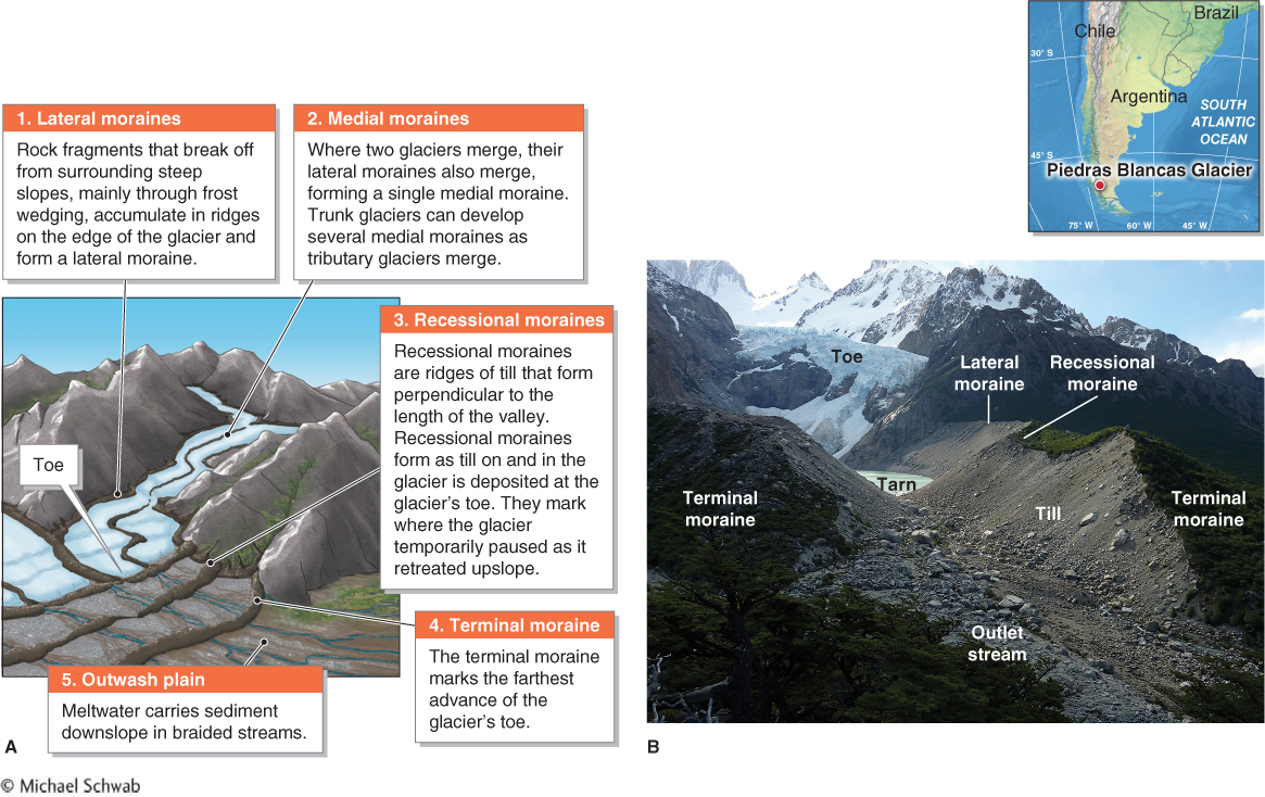
Alpine glaciers transport material of all sizes and pile it into jumbled, unsorted moraines composed of till. A moraine is a heap of unsorted sediments deposited by a glacier. Till is any debris deposited by a glacier without the influence of running water. In most glaciated regions, moraines are prominent landforms. There are many kinds of moraines, each identified by where it forms with respect to the movement of the glacier. Moraine types include lateral moraines, medial moraines, recessional moraines, and terminal moraines. A recessional moraine forms where the toe of the glacier pauses as it is retreating. A terminal moraine marks the farthest advance of the glacier’s toe before it begins retreating. These moraine types are illustrated in Figure 17.28.
moraine
A heap of unsorted sediments deposited by a glacier.
till
Any debris deposited by a glacier without the influence of running water.
recessional moraine
A ridge of till that forms at the toe of a glacier; formed where the glacier pauses as it is gradually retreating upslope.
terminal moraine
A moraine that marks the farthest advance of a glacier’s toe.
Moraines provide important information about the history of glaciation in a region and the history of an individual glacier. Once the age of a terminal moraine is known, estimating the average annual rate of glacial retreat is straightforward: Measure the distance between the toe of the glacier and the terminal moraine, and divide that distance by the age of the terminal moraine. Crunch the Numbers applies this method.
Deposits by Ice Sheets
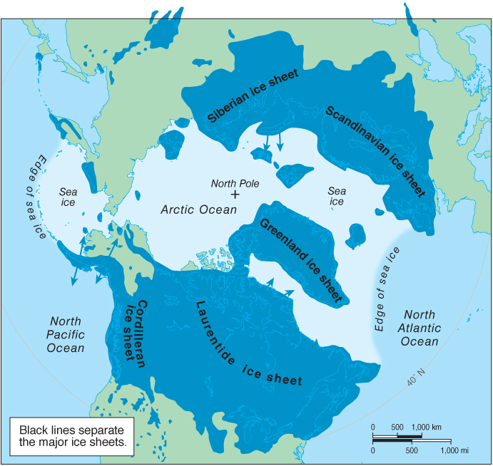
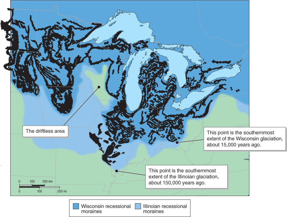
We learned in Section 6.2 that Milankovitch cycles and the resulting orbital forcing cause glacial and interglacial cycles. The most recent glacial period, which is called the Wisconsin glaciation, ended about 12,000 years ago. During the Wisconsin glaciation, large ice sheets covered the high latitudes of the Northern Hemisphere (Figure 17.29). These ice sheets scoured the landscape and deposited enormous amounts of glacial drift.
CRUNCH THE NUMBERS: Calculating the Rate of Glacial Retreat
CRUNCH THE NUMBERS: Calculating the Rate of Glacial Retreat
Calculate the average annual rate of retreat for the Exit Glacier in Alaska (see the opening photo in Chapter 6). It has retreated upslope 3,200 m (10,560 ft) from its terminal moraine, which has been determined by dendrochronology to be 200 years old.
Question 17.10
Average annual rate of retreat in meters per year:
Question 17.11
Average annual rate of retreat in feet per year:
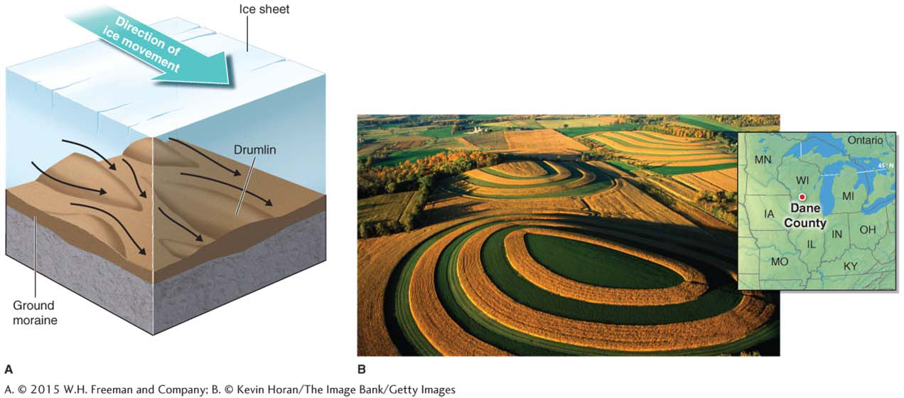
Many areas of northern North America today are covered by nearly continuous layers of glacial sediments deposited by the Laurentide ice sheet. The sediments were deposited unevenly, resulting in an undulating, hummocky, and mounded surface called a ground moraine. In some places, these glacial deposits were molded into identifiable landforms by the moving ice sheet or by meltwater streams flowing beneath the glacier, or by a combination of ice and streams. Ice sheets produce many of the same kinds of depositional features that alpine glaciers create, such as terminal and recessional moraines. They also create landforms that are unique to ice sheets. Drumlins (Irish Gaelic for “hills”), for example, are elongated hills composed of till that was deposited by a moving ice sheet (Figure 17.30).
drumlin
An elongated hill formed by a moving ice sheet.
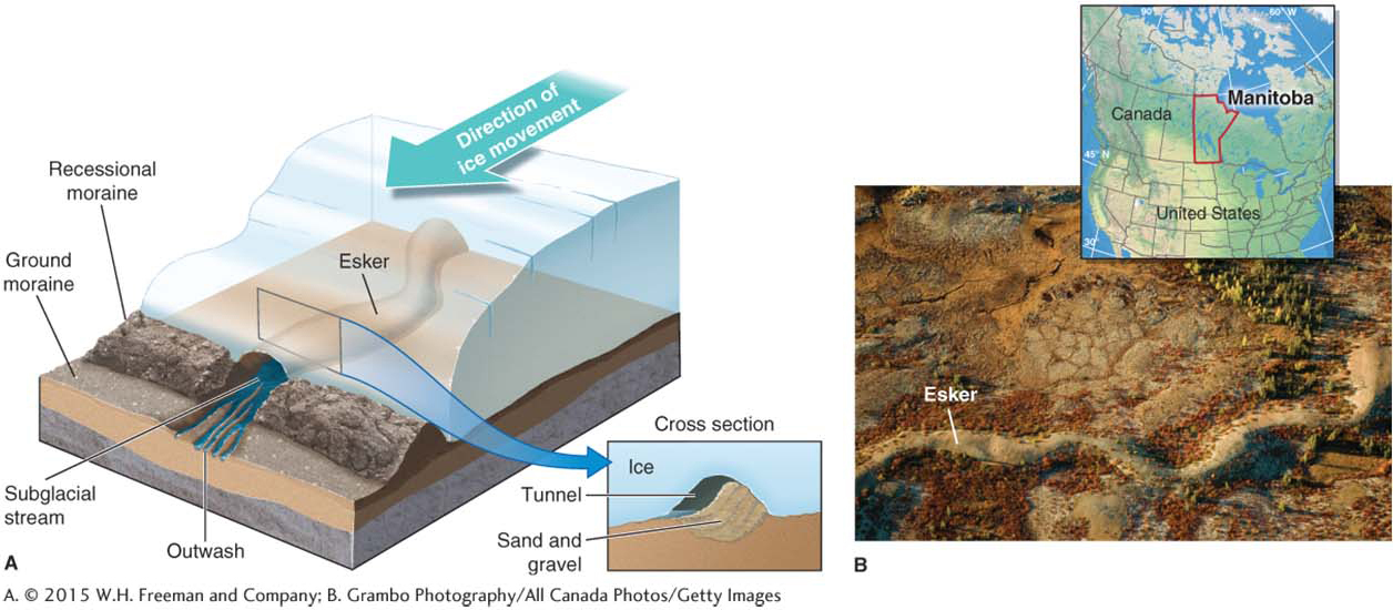
Another common landform deposited by ice sheets is an esker (meaning “ridge” in Irish Gaelic), a long ridge of sorted sand and gravel deposited by a subglacial stream. Eskers may run continuously for tens of kilometers in length parallel to the direction of ice sheet movement (Figure 17.31).
esker
A long ridge of sorted sand and gravel deposited by a subglacial stream.
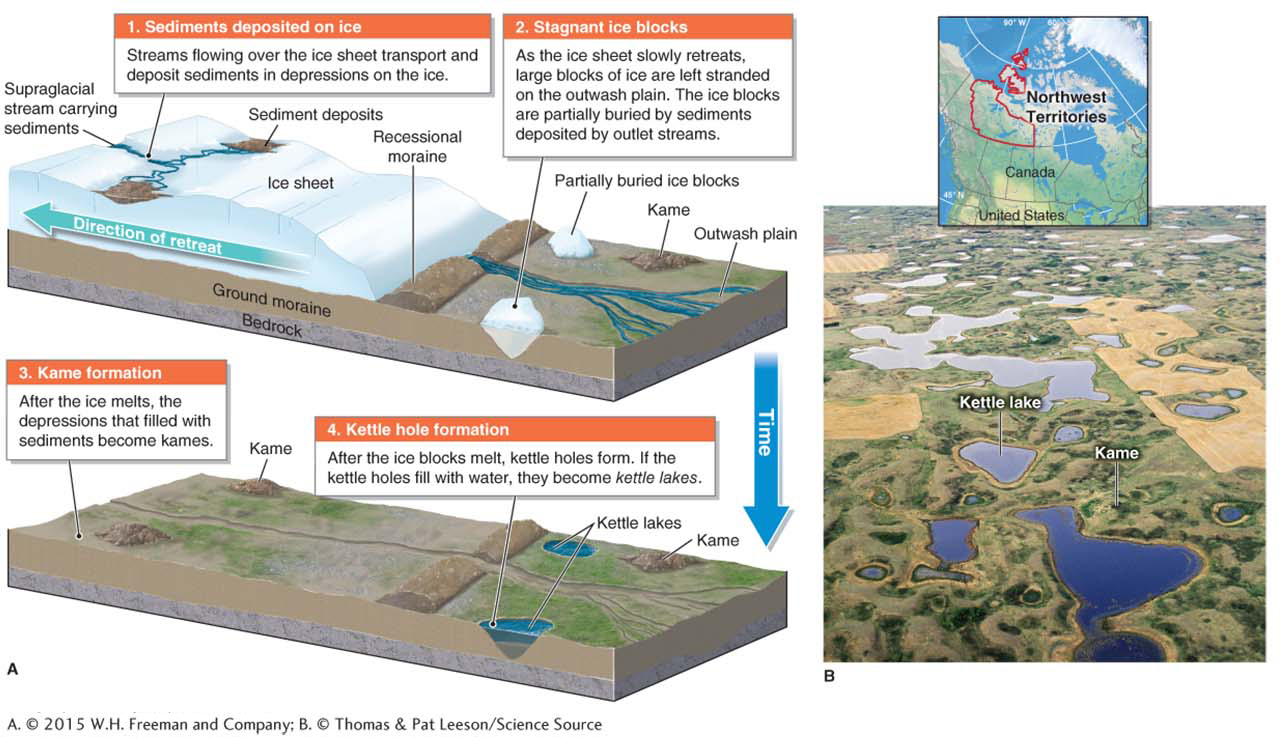
Many areas across North America consist of rounded hills called kames, which are mounded accumulations of glaciofluvial sediments. The formation of kames is not well understood, but they are thought to be formed in part as sediments accumulate on top of depressions in a melting ice sheet. After the ice melts, the sediments are piled in mounds composed of sand and gravel.
Subglacial streams flowing beneath the Laurentide ice sheet deposited sediments on flat outwash plains where they exited the glacier. Large stagnant blocks of ice that broke from the retreating ice sheet were buried in these sediments. When the blocks eventually melted, they formed depressions called kettle holes. When kames and kettle holes form in the same area, the result is kame-
kame-and-kettle topography
A glaciofluvial landscape dominated by irregular mounds and shallow depressions or lakes.
In addition to creating kame-
Glacial Dust: Loess
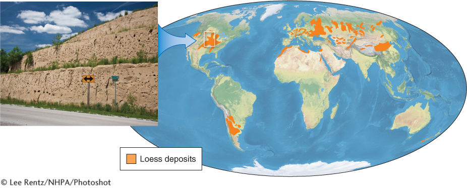
About 10% of the surface of the continents, mostly at midlatitudes, is covered by loess deposits. Loess is made up of wind-
loess
(pronounced lehss) Wind-
Many loess deposits were formed by processes that are no longer active. The Pleistocene ice sheets and mountain glaciers in North America and Scandinavia formed loess accumulations when summer meltwater deposited silt and clay onto the outwash plain. Cold winters reduced the stream flow, exposing the sediments to strong katabatic winds (see Section 4.4). These winds picked up and transported the fine sediments and deposited them in loess accumulations.
About 30% of the United States is covered by loess deposits, and Europe has extensive loess deposits, as shown in Figure 17.34. Not all loess is glacially derived. In some areas, such as central China, loess was formed by windblown dust originating in deserts rather than glacial outwash plains.