To many, deserts are among Earth’s most beautiful and dramatic landscapes. In the desert, there is a contrast between the harsh, barren, and inhospitable nature of the place and its endless vistas, intriguing physical landforms, and sense of quiet timelessness. Prominent desert landscapes include regs, ergs, mesa-and-butte terrain, inselbergs, basin-and-range topography, and badlands. Each of these landscapes bears the signature of water, wind, and time.
Regs: Stony Plains
A flat, stony plain, or reg, may be formed by either of two different processes. The first is aeolian sorting, which results in accumulations of similarly sized particles, ranging in size from fields of boulders to sand dunes composed of quartz grains to loess deposits composed of fine silt. Small particles blow farthest, while heavier particles travel shorter distances.
reg
A flat stony plain.
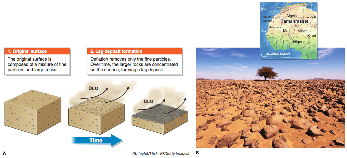
Most rocks are not moved at all by the wind. As lighter particles, such as clay and silt, are transported away in the process of deflation, an accumulation of rocks, called a lag deposit(Figure 18.12), may develop.
lag deposit
A reg that results from the removal of smaller particles, such as clay and silt, by deflation.
GEO-GRAPHIC: Lag deposit reg. (A) A lag deposit forms when gravel and rocks are concentrated at the ground surface after smaller and lighter particles have blown away. (B) This lag deposit is southwest of Tamanrasset in southern Algeria.
(B. Taghit/Flickr RF/Getty Images)
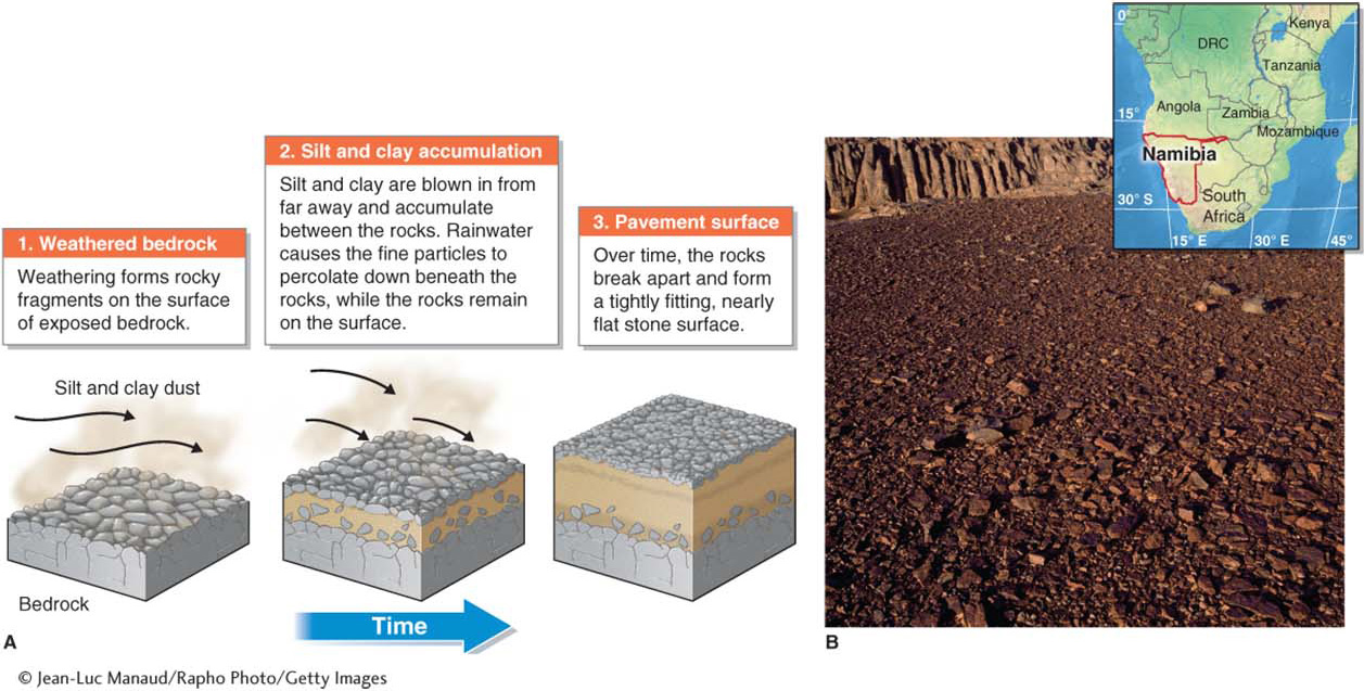
The second process forms regs consisting of stones that are tightly interlocked, as if they had been set in place by people. Desert pavement is a flat, rocky surface that resembles a cobblestone street. Beneath desert pavement are aridisol soils composed of clay and silt. These soils often contain few or no stones. If deflation formed desert pavement, then one would expect to find stones within the soil that would later be brought to the surface by deflation. Recent research indicates, however, that desert pavement may form as desert soils are built up on bare bedrock (Figure 18.13).
desert pavement
A reg composed of tightly interlocked rocks that resembles a cobblestone street.
GEO-GRAPHIC: Desert pavement formation. (A) Desert pavement forms as desert soils are built up when clays and silts accumulate beneath rocks. (B) This reg in the desert of western Namibia is composed of desert pavement.
Regs, whether formed as lag deposits or desert pavement, occur in all deserts. They are also called hamada in the Sahara and gibber plains in Australia.
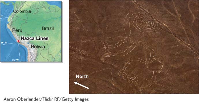
The top sides of the rocks in regs are often coated with rock varnish. Overturning or removing the rocks reveals a lighter surface. In some areas of southern Peru, the desert’s surface was scraped and overturned by people of the ancient Nazca civilization to draw huge geoglyphs on the desert floor (Figure 18.14).
Nazca geoglyphs. This aerial photograph shows a monkey (about 100 m, or 330 ft, across) carved into a reg in southern Peru. About two dozen strange figures and odd geometric shapes and patterns were etched into the Peruvian desert floor by the now-vanished Nazca civilization about 1,500 to 2,000 years ago. Although there are many hypotheses about these works, their purpose is not fully understood.
(Aaron Oberlander/Flickr RF/Getty Images)
Ergs: Sand Seas
Question
18.10
What is a sand sea?
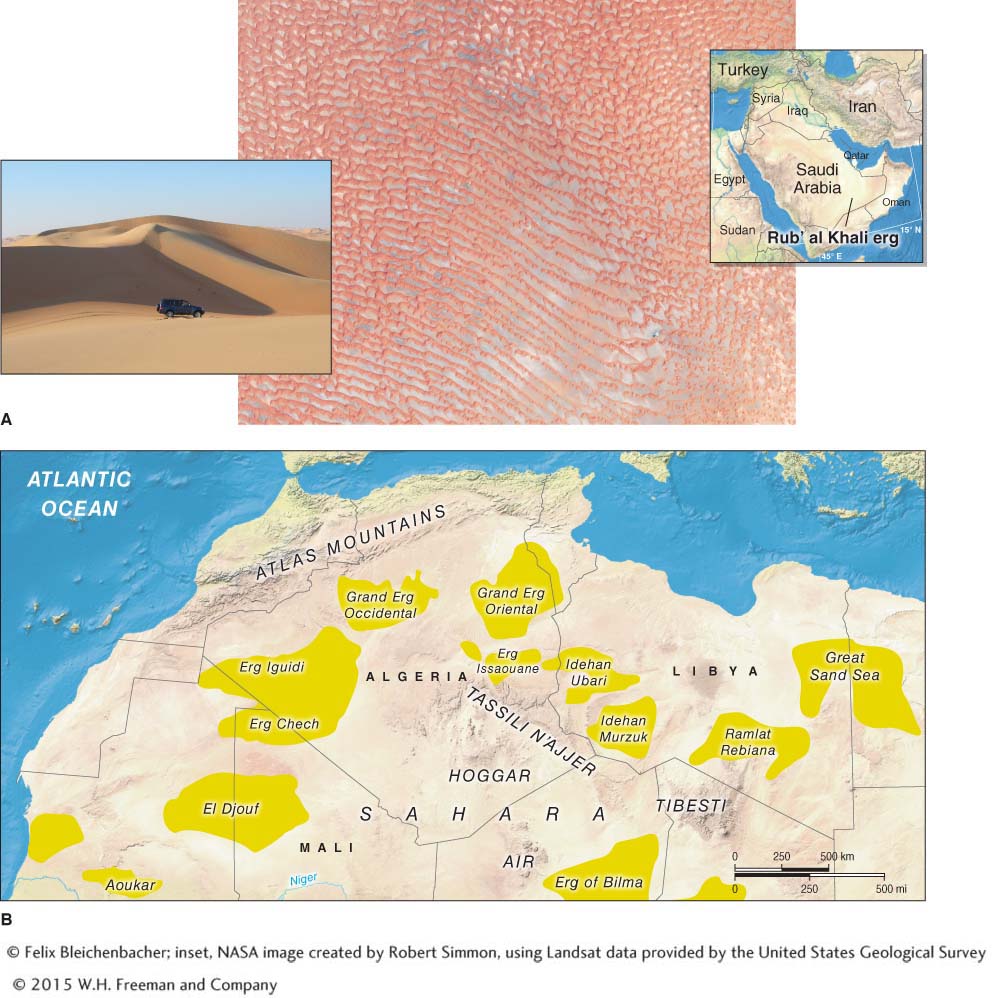
A sand sea, or erg, is a desert region larger than 125 km2 where sand covers at least 20% of the desert floor. Most ergs are in the northern Sahara.
An erg (Arabic for “dune field”) is a desert landscape that is dominated by actively moving sand dunes. Ergs, also called sand seas, are among Earth’s most dramatic landscapes. They are devoid of vegetation and, by definition, are at least 125 km2 (50 mi2) in extent. In all ergs, sand covers at least 20% of the desert floor. Any type of sand dune may form in an erg, and some ergs are flat sheets of sand with few dunes.
erg
A desert landscape dominated by actively moving sand dunes.
Ergs are most common where the subtropical high creates arid conditions. Ergs cannot develop in humid climates because vegetation will become established and stabilize the sand. The source of sand for ergs varies, but it is often derived from glacial outwash plains, dry lake beds, or river deltas. In much of the Middle East, such as Saudi Arabia, geologic uplift exposed marine sediments that were eroded to form ergs.
Page 591
It takes hundreds of thousands to millions of years for large ergs to develop. Large ergs are found in the Namib Desert of Namibia, the Taklamakan Desert in China, the Gobi Desert in Mongolia, interior Australia, and portions of southwestern North America. Earth’s largest erg is the Rub’ al Khali (or the Empty Quarter) on the Arabian Peninsula. It is estimated to have been active for over a million years. It covers 583,000 km2 (225,000 mi2) and stretches from Saudi Arabia into Yemen, Oman, and the United Arab Emirates. After the Rub’ al Khali, Earth’s largest ergs are found in the Sahara, particularly in Algeria and Libya (Figure 18.15).
Ergs. (A) This astronaut photograph shows a small portion of the Rub’ al Khali erg (or the Empty Quarter) in Oman. The sand dunes shown here, mainly longitudinal dunes, are about 100 m (330 ft) high (inset photo). Salt flats (or sabkhas) have formed between the dunes. (B) The Sahara has the greatest concentration of ergs of any region. The largest ones are mapped here.
Like sand seas, mesas and buttes come to mind for many when they picture a typical desert landscape. Mesa-and-butte terrain, however, is determined more by the composition and structure of the bedrock than by climate. Mesa-and-butte terrain also occurs in humid climates, but it is easiest to see in arid desert climates because it is not obscured by vegetation. The tepuis in Venezuela and western Guyana, for example, form mesa-and-butte terrain that is covered by tropical savanna and tropical rainforest.
Page 592
Page 593
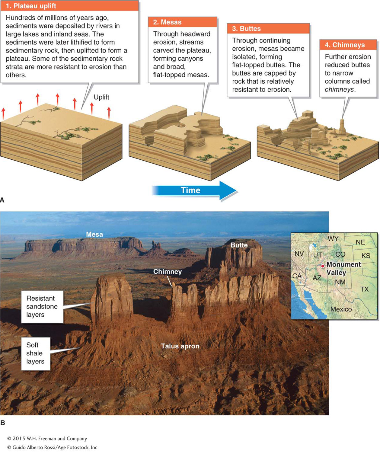
Most mesas, buttes, and chimneys occur where a plateau has been uplifted, weathered, and eroded by flowing water. A mesa is flat-topped elevated area with one or more cliff-face sides and is wider than it is tall. A butte is a medium-sized flat-topped hill with cliff-face sides and is taller than it is wide. A chimney is a slender spire of rock with a flat top. Chimneys are far less common than mesas and buttes.
mesa
A flat-topped elevated area with one or more cliff-face sides that is wider than it is tall.
butte
A medium-sized flat-topped hill with cliff-face sides that is taller than it is wide.
chimney
A slender spire of rock with a flat top.
Although mesa-and-butte terrain can form on lava flows without geologic uplift, it is most common in sedimentary rocks that have been uplifted. Examples of mesa-and-butte terrain are found throughout the southwestern United States, particularly in Monument Valley on the Colorado Plateau. Figure 18.16 illustrates how mesa-and-butte terrain develops.
GEO-GRAPHIC: Formation of mesas and buttes. (A) Mesa-and-butte terrain forms as a plateau consisting of sedimentary rock is eroded. (B) In Monument Valley, on the Colorado Plateau in northern Arizona and southern Utah, buttes and chimneys form as slabs of sandstone shear off along vertical joints and accumulate as talus on the slopes. The gentle slope at the base of the butte is composed of relatively soft shale that is too weak to develop a vertical cliff face. Where talus accumulates along the length of a mesa or linear escarpment, a talus apron results.
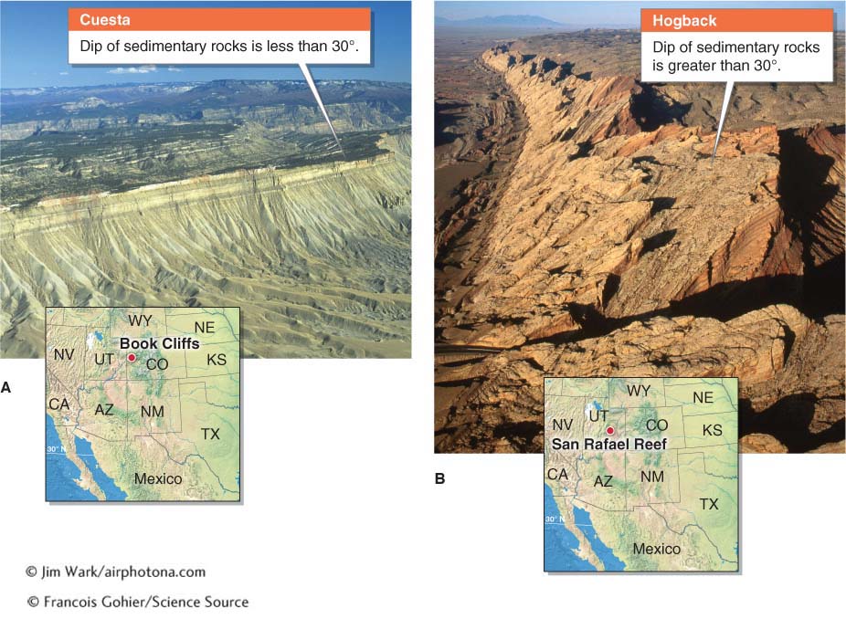
The surface of a flat-topped mesa has little or no dip (or slope). Dipping occurs where sedimentary rock has been folded or tilted through faulting (see Section 12.4). Where sedimentary rock at the ground surface dips gently, a cuesta is formed (Figure 18.17A). Hogbacks form where sedimentary rock at the ground surface dips steeply (Figure 18.17B).
Cuestas and hogbacks. (A) Cuestas, such as the Bookcliffs near Grand Junction, Colorado, are formed where sedimentary rock dips less than 30° from horizontal. (B) Hogbacks are composed of erosion-resistant sedimentary rock layers with a dip of 30° or more from horizontal. This hogback is the San Rafael Reef, a steeply tilted layer of sandstone and limestone in eastern Utah.
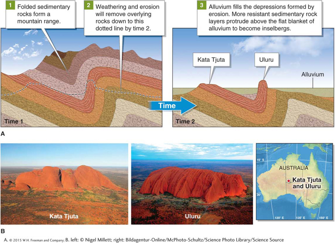
An inselberg (meaning “island mountain”) is a large, weathered outcrop of bedrock surrounded by a flat plain. Inselbergs are exposed at the land surface through the process of exhumation (the removal of overlying sediments and rock). Inselbergs form because they are more resistant to erosion than the sediments and rocks surrounding them. Like mesas and buttes, inselbergs are not restricted to desert climates, but they are easiest to observe there. Kata Tjuta (or the Olgas) and Uluru (or Ayers Rock) in central Australia are two dramatic examples of inselbergs formed from sedimentary rocks (Figure 18.18).
inselberg
A large, weathered outcrop of bedrock surrounded by a flat alluvium-filled plain.
GEO-GRAPHIC: Inselbergs, Australia. (A) Kata Tjuta and Uluru were formed through differential erosion of sandstone. (B) Kata Tjuta (left) and Uluru (right) are about 30 km (18 mi) apart. They are composed of the same 600-million-year-old erosion-resistant arkose, a type of sandstone.
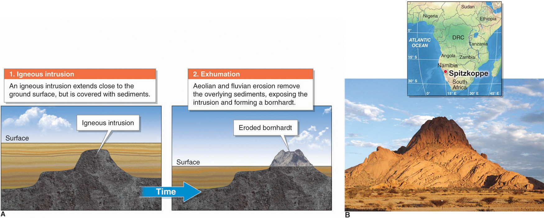
Bornhardts are inselbergs that take on a more rounded form and are usually derived from erosion-resistant crystalline rocks such as granite or gneiss. As the land surface is lowered through erosion, a crystalline rock body, such as a pluton, batholith, or laccolith (see Section 13.2), is exposed and rounded through weathering (Figure 18.19).
GEO-GRAPHIC: The making of a bornhardt. (A) Bornhardts are formed by exhumation of an igneous intrusion through erosion. Once the igneous intrusion is exposed, erosion begins to wear it down, but at a slower rate than the surrounding weaker sediments. (B) Spitzkoppe, in Namibia, is a bornhardt composed of granite.
(David du Plessis/Gallo Images ROOTS Collection/Getty Images)
Basin-and-Range Topography
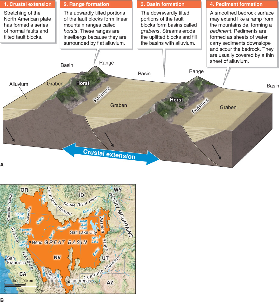
The Basin-and-Range Province is located in the Great Basin of the western United States, where the crust is being stretched through rifting (see Figure 14.21), forming a large internal drainage basin containing a series of tilted fault blocks called horsts and a series of valleys called grabens. Figure 18.20 illustrates the process that has created the Basin-and-Range Province.
Basin-and-Range Province
A landscape located in the southwestern United States where the crust is being stretched apart through rifting, forming a large internal drainage basin with a series of tilted fault blocks.
GEO-GRAPHIC: Basin-and-range topography. (A) Basin-and-range topography has formed in the Great Basin, where the North American crust is being stretched, creating a series of parallel inselbergs (called horsts) surrounded by flat, alluvium-filled valleys (called grabens). (B) This map shows the geographic extent of the Great Basin.
Basin-and-range topography is not restricted to deserts. It is included in this section, however, because it is a prominent desert landscape in western North America. The only comparable region of widespread extension of continental crust is in the East African rift zone.
Page 596
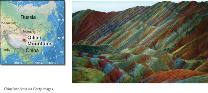
Badlands
Badlands are landscapes riddled by rills and gullies (Figure 18.21). They occur mostly in arid to semiarid environments where slopes are largely unvegetated and weak rocks, such as shale, are eroded by infrequent but intense rainfall. They often have loose, dry, clay-rich soils. Badlands are “bad” because they cannot be farmed and because they are difficult to cross. They range in size from a few grouped hillsides to thousands of square kilometers. Badlands often have many fossils preserved in their sedimentary rocks.
Badlands. These badlands are in the Qilian Mountains in China. They are composed of siltstone, mudstone, and shale. The high levels of minerals like iron and manganese in the rocks give them vibrant hues.