2.3 ENVIRONMENT
GEOGRAPHIC INSIGHT 1
Environment: North America’s intensive use of resources has an enormous impact on the environment. Although home to only 5 percent of the world’s population, North America produces 26 percent of the greenhouse gases released globally that are related to human activity. North American lifestyles have major environmental impacts, including the depletion and pollution of water resources and fisheries and the destruction of huge amounts of habitat for wild plants and animals.
North America’s wide range of resources, plus its seemingly limitless stretches of forest and grasslands, diverted attention for many years from the environmental impacts of settlement and development. However, it is becoming impossible to ignore the many environmental consequences of the North American lifestyle. This section focuses on a few of those consequences: climate change and air pollution, depletion and pollution of water resources and fisheries, and habitat loss.
Climate Change and Air Pollution
On a per capita basis, North Americans contribute among the largest amounts of greenhouse gases to the Earth’s atmosphere. Only a very few countries have higher per capita emissions. This is largely a result of North America’s high consumption of fossil fuels, which is related to several factors. One of these is North America’s dominant pattern of urbanization, characterized by vast and still-
Canada’s government was one of the first to commit to reducing the consumption of fossil fuels. Until recently, the United States resisted such moves, fearing damage to its economy. Both countries are now exploring alternative sources of energy, such as solar, wind, geothermal, and nuclear power. So far, neither country has been able to reduce its levels of greenhouse gas emissions, or even the rate at which these emissions are growing. However, both Canada and the United States possess the technological capabilities needed to lead the world in shifting over to cleaner sources of energy.
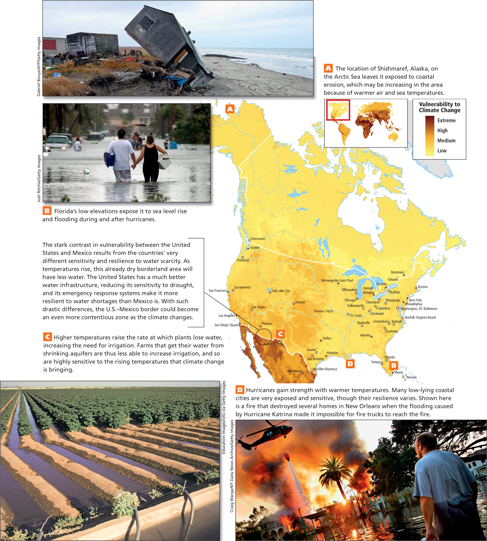
Vulnerability to Climate Change Both Canada and the United States are vulnerable to the effects of climate change. Dense population centers on the Gulf of Mexico and on the Atlantic coast are very exposed to hurricanes, which may become more violent as oceans warm (Figure 2.5B, D). Sea level rise and coastal erosion, caused by the thermal expansion of the oceans, are already affecting many coastal areas along the Arctic coast of North America (see Figure 2.5A). Here, at least 26 coastal villages are being forced to relocate inland, at an estimated cost of $130 million per village. Meanwhile, many arid farming zones will dry further as higher temperatures reduce soil moisture, making irrigation crucial (see Figure 2.5C). In all of these areas, resilience to climate change is bolstered over the short term by excellent emergency response and recovery systems. Long- 30. GLACIER NATIONAL PARK
THINKING GEOGRAPHICALLY
Use the Photo Essay above to answer these questions.
Question 2.2
A Describe the coastal erosion illustrated by this photo.
Question 2.3
B What elements of this community’s emergency response system may be compromised by this flooding?
Question 2.4
C How might irrigation reduce vulnerability to climate change but also result in more greenhouse gas emissions?
Question 2.5
D Why are stronger hurricanes more likely as the climate warms?
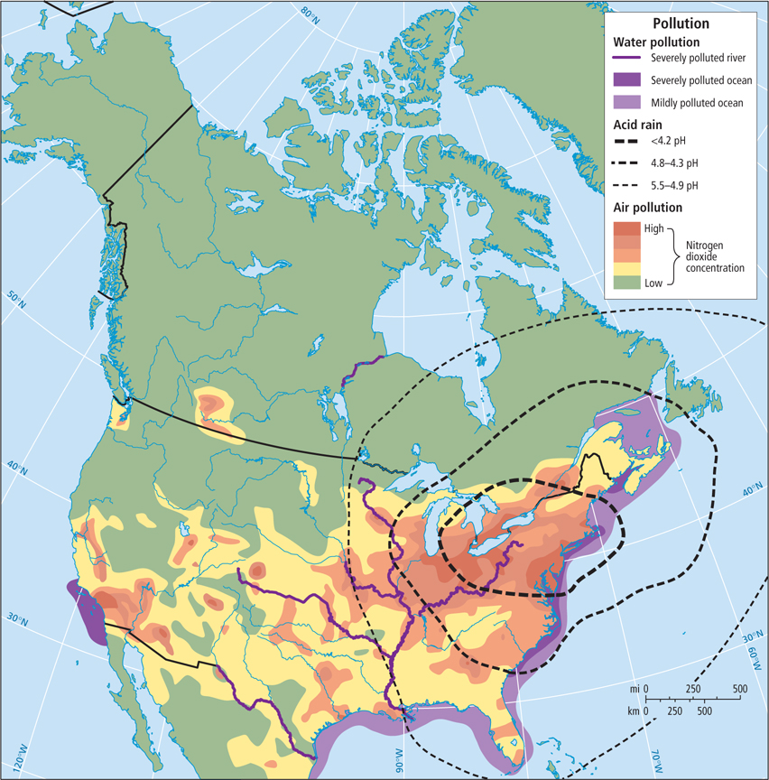
Air Pollution In addition to climate change, most greenhouse gases contribute to various forms of air pollution, such as smog and acid rain. Smog is a combination of industrial emissions, car exhaust, and water vapor that frequently hovers as a yellow-
smog a combination of industrial emissions, car exhaust, and water vapor that frequently hovers as a yellow-
acid rain precipitation that has formed through the interaction of rainwater or moisture in the air with sulfur dioxide and nitrogen oxides emitted during the burning of fossil fuels, making it acidic
The United States, with its large population and extensive range of industries, is responsible for the vast majority of acid rain in North America. Because of continental weather and wind patterns, however, the area most affected by acid rain encompasses a wide swath on both sides of the eastern U.S.–Canada border (Figure 2.6). The eastern half of the continent, which includes the entire Eastern Seaboard from the Gulf Coast to Newfoundland, also has significant impacts from acid rain.
Water Resource Depletion, Pollution, and Marketization
People who live in the humid eastern part of North America find it difficult to believe that water is becoming scarce even there. Consider the case of Ipswich, Massachusetts, where the watershed is drying up as a result of overuse. There, innovators are saving precious water through conservation strategies in their homes and businesses. Elsewhere, as populations and per capita water usage grow, conflicts over water are becoming more and more common.
34. RAINWATER CASH
Water Depletion In North America, water becomes increasingly precious the farther west one goes. The Great Lakes Agreement (formally known as the Great Lakes–
Well before people were aware of the ramifications of making drastic changes to ecosystems, the city of Chicago, in order to clean up sewage it had been dumping into Lake Michigan, gained permission to reverse the flow of the Chicago River. The river now flows into the Mississippi, ultimately transferring Chicago’s wastewater to the Gulf of Mexico. This diversion, which moves water at 3200 cubic feet per second from the Great Lakes, has opened the doors to requests from cities, not even on the shores of the Great Lakes, to gain access to the lake water. Cities in places as far away as Alabama have looked at the lakes as a potential water source for their growing needs.
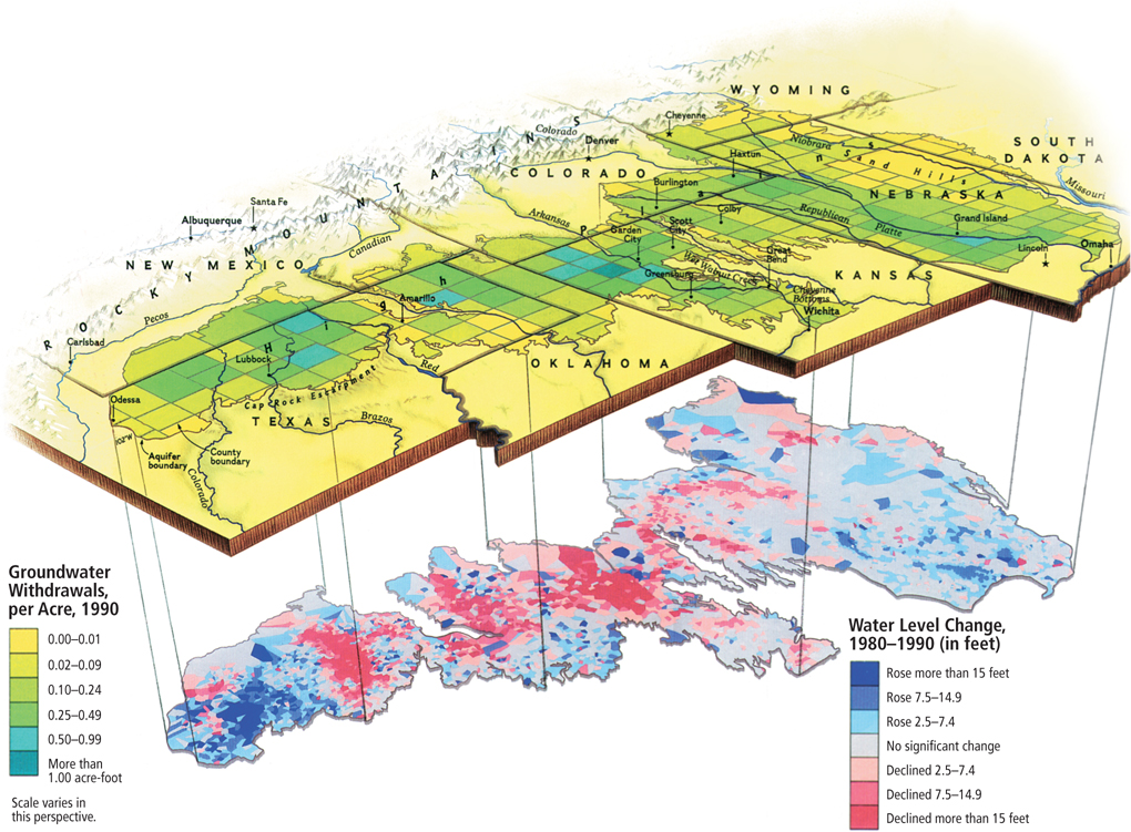
On the North American Great Plains, rainfall varies considerably from year to year. To make farming more secure and predictable, taxpayers across the continent have subsidized the building of pumps and stock tanks for farm animals, and aqueducts and reservoirs for crop irrigation. However, more and more irrigation is being drawn from fossil water that has been stored over the millennia in aquifers. The Ogallala aquifer (Figure 2.7) underlying the Great Plains is the largest in North America. In parts of the Ogallala, water is being pumped out at rates that exceed natural replenishment by 10 to 40 times.
As mentioned in the opening vignette, fruit and vegetable crops in California are routinely irrigated with water from surrounding states. Such irrigation, involving expensive and massive engineering projects, accounts for some of the water that goes into the virtual water footprint of U.S. consumers, as discussed in Chapter 1 (see also Table 1.1). This water also supplies the cities of Southern California, which are built on land that was once desert. Water is pumped from hundreds of miles away and over mountain ranges. California uses more energy to move water than some states use for all purposes. Moreover, irrigation in Southern California, especially that which is drawn from the Colorado River, deprives Mexico of this much-
Citizens in western North America are now recognizing that the use of scarce water for irrigating agriculture, raising livestock, and keeping lawns and golf courses green in desert environments is unsustainable. Conflicts over transporting water from wet regions to dry ones, or from sparsely inhabited to urban areas, are ongoing and have halted some new water projects. However, government subsidies have kept water artificially cheap, and in the past, new water supplies have always been found and harnessed, creating little incentive to change.
Water Pollution In the United States, 40 percent of rivers are too polluted for fishing and swimming, and more than 90 percent of the riparian areas (the interface between land and flowing surface water) have been lost or degraded. Pollution in the rivers of North America comes mainly as storm-
In the 1970s, scientists studying coastal areas began noticing dead zones where water is so polluted that it supports almost no life. Dead zones occur near the mouths of major river systems that have been polluted by fertilizers and pesticides washed from farms and lawns when it rains. A large dead zone is in the Gulf of Mexico near the mouth of the Mississippi, and similar zones have been found in all U.S. coastal areas. Even Canada, where much lower population density means that rivers are generally cleaner, has dead zones on its western coast.
A recently discovered type of water pollution involves pharmaceuticals, such as antibiotics, that are excreted by humans and are not removed during water purification processes. These chemicals then make their way into rivers and lakes, where they enter the food system in drinking water or through fish.
Water Marketization North Americans are used to paying for water, but the cost has usually been just high enough to cover extraction, purification, and delivery in pipes. Now, threats of polluted drinking water are beginning to change the way water is viewed. For example, in the last few years the public, in response to aggressive advertising, has been buying bottled water even when tap water is perfectly safe. A number of North American communities with abundant fresh water have agreed to sell water to beverage companies for bottling without understanding that massive water withdrawals from local aquifers can cause geologic subsidence, loss of aquatic habitats, and the depletion and pollution of natural wells and springs. Eventually, as these communities realize that their own low-
Loss of Habitat for Plants and Animals
Before the European colonization of North America, which began soon after 1500, the environmental impact of humans in the region was relatively low. Though North America was by no means a pristine paradise when Europeans arrived, millions of acres of forests and grasslands that had served as habitats for native plants and animals were cleared to make way for European-
THINKING GEOGRAPHICALLY
Use the Photo Essay above to answer these questions.
Question 2.6
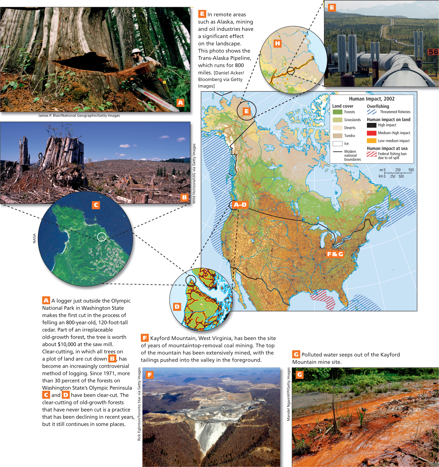
A Why might it make economic and environmental sense to keep old-
Question 2.7
E What are some threats to the environment posed by the Trans-
Question 2.8
F What kind of mining is mountaintop removal?
Question 2.9
G What clues are there that this water may be toxic?
Oil Drilling
In many coastal and interior areas of North America, oil extraction is a large and potentially environmentally devastating industry. This often-
ON THE BRIGHT SIDE
Green Living at a Regional and Global Scale
North Americans are trying to figure out what they can do in their daily lives to ameliorate looming environmental crises. Solutions, such as greener living—which involves recycling, driving less, growing a food garden, and improving home energy efficiency—
In other places too, oil extraction has a dramatic effect on the environment. Along the northern coast of Alaska, the Trans-
With one-
Logging
Though widespread forest clearing for agriculture is now rare, logging is common throughout North America, where it remains especially important along the northern Pacific coast and in the southeastern United States. Logging in these areas provides most of the construction lumber and much of the paper used in Canada, the United States, and, increasingly, in parts of Asia.
Although the logging industry provides jobs and an exportable commodity, it has been depleting the continent’s forests. Environmentalists have focused on the damage created by the logging industry, especially on clear-
clear-
Coal Mining and Use
In many remote interior areas of North America, coal mining is a major industry that is damaging to the environment. Strip mining, in which vast quantities of earth and rock are removed in order to extract underlying coal, can result in visual wastelands and in huge piles of mining waste called tailings that pollute waterways and threaten communities that depend on well water. Particularly damaging is a form of strip mining known as mountaintop removal, in which the whole top of a mountain is leveled and the tailings are pushed into surrounding valleys, resulting in the pollution of entire watersheds (see Figure 2.8F, G).
When coal is burned, ash is produced, and it is difficult to find a safe place to store the huge volumes of toxic ash that result from coal-
Urbanization and Habitat Loss
An important aspect of urbanization is urban sprawl (see the “Farmland and Urban Sprawl” section). For several decades, middle-
urban sprawl the encroachment of suburbs on agricultural land
As North American native plants and animals have been forced into ever smaller territories, many have died out entirely and been replaced by nonnative species (European and African grasses and the domestic cat, for example) brought in by humans either purposely or inadvertently (see Figure 2.23). Estimates vary, but at least 4000 nonnative species have invaded North America. An example is the Asian snakehead fish, which is rapidly invading the Potomac River, where it eats baby bass and fiercely competes with native fish for food.
29. SNAKEHEAD REPORT
THINGS TO REMEMBER
GEOGRAPHIC INSIGHT 1
Environment North America’s intensive use of resources has an enormous impact on the environment. Although home to only 5 percent of the world’s population, North America produces 26 percent of the greenhouse gases released globally that are related to human activity. North American lifestyles have major environmental impacts, including the depletion and pollution of water resources and fisheries and the destruction of huge amounts of habitat for wild plants and animals.
While many parts of North America are exposed to multiple climate-
change impacts, North America is also a very resilient region. Its overall vulnerability to climate change is generally low compared to that of other world regions. Water pollution in North America is now a major problem, especially in the United States, where 40 percent of the rivers are too polluted for fishing or swimming.
Though widespread forest clearing for agriculture is now rare, logging is common throughout North America and remains especially important along the northern Pacific coast and in the southeastern United States.
In many remote interior areas of North America, coal mining is a major industry that is damaging to the environment.