16.4 Rising Waters: Stream Flooding
Describe two modes of stream flooding and explain how people reduce their vulnerability to flooding.
A flood is inundation by water in a region not normally covered by water. Flooding occurs when the volume of water moving through a stream exceeds the capacity of the stream channel. Most low-
flood
Inundation by water in a region not normally covered by water, which results when stream discharge exceeds stream channel capacity.
Flash Floods
A flash flood occurs with sudden, intense rainfall or the collapse of a dam. Flash floods are very dangerous because they often occur with little or no warning. Flash floods are most common in arid regions where rains come as sudden thunderstorm showers. Dry streambeds in deserts can become torrents of raging water within minutes following a thunderstorm.
flash flood
A flood that occurs with sudden, intense rainfall or dam collapse, often with little or no warning.
The worst flash flood disaster in the United States was the Johnstown Flood in 1889. At about 3:00 p.m. on May 31, the South Fork Dam on the Conemaugh River in Pennsylvania collapsed. The earthen dam was poorly constructed and failed when torrential rains saturated and weakened it. Twenty million tons of water formed a wall 20 m (60 ft) high that raced down the valley leading to Johnstown. It took only 10 minutes for the water to destroy much of the town of 30,000 people. The flood left more than 2,000 people dead and caused $17 million in damage in the town.
Seasonal Floods
In contrast to flash floods, seasonal floods are predictable floods that occur with seasonally heavy rain or snowmelt. Seasonal floods follow prolonged rains that saturate the soil and inhibit more water from infiltrating the ground. If rains continue, their water must flow over land rather than into the ground. As a result, water spills out of the stream channel and inundates the surrounding floodplain. Seasonal flooding poses less of a threat to human life than flash flooding because often the water rises slowly and there is ample time to evacuate.
seasonal flood
A predictable period of flooding that occurs with seasonally heavy rain or snowmelt.
Seasonal flooding is common throughout South Asia because of its heavy monsoon rains (see Section 4.4) and tropical cyclones (see Section 5.3). In late July of 2011, the powerful tropical storm Nock-

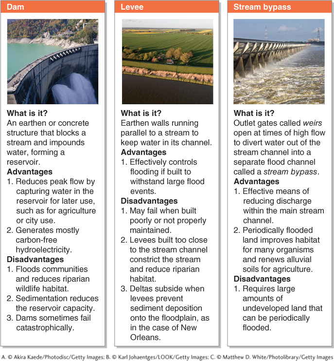
Controlling the Waters
The most effective tools to reduce the risk of flooding on floodplains are dams, levees, and stream bypasses. Engineers design these flood control structures so that they can handle the worst-
There are two ways to summarize the risk of flooding for a given location: the annual probability and the recurrence interval. The annual probability of flooding specifies the chances of a given discharge amount in a locality for any given year. For example, for a river that normally flows at 10,000 ft3/s, the annual probability of a 50,000 ft3/s flow might be calculated to be 1%. This probability means that in any given year, there is a 1% chance of a 50,000 ft3/s discharge event. With each passing year, the probability increases arithmetically, such that after 100 years, there is a 100% chance of a 50,000 ft3/s discharge event. Such calculations are based on historical climate and stream flow data.
The recurrence interval states how many years, on average, will pass between high-