19.1 Coastal Processes: Tides, Waves, and Longshore Currents
Discuss the role of tides and wave energy in coastal landform development.
We begin our exploration of coastal landforms by examining the daily sea-
Tidal Rhythms
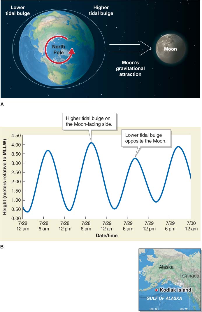
If you have ever visited the ocean, you may have noticed the effects of tides. Tides are the rise and fall of sea level caused by the gravitational effects of the Moon and the Sun. At low tide, you may have seen algae and barnacles clinging to slippery rocks. At high tide, these organisms are submerged.
tide
The rise and fall of sea level caused by the gravitational effects of the Moon and the Sun.
In a classical sense taken from astronomy, “tides” are distortions of the shape of one body by the gravitational pull of another body. The gravitational pull of the Moon and the Sun distorts Earth’s atmosphere, its oceans, and the body of the planet itself. For our purposes, however, the term “tide” will be used to refer to the twice-
Question 19.1
What causes the tides?
Tides are caused by the gravitational effects of the Moon and Sun.
Tides are caused by the tide-
The tide-
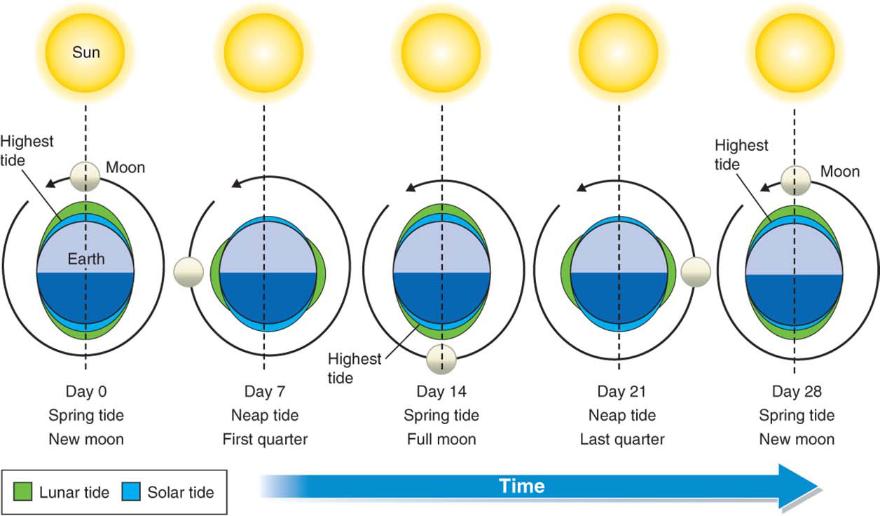
Sometimes, tides are unusually high or low. When Earth, the Moon, and the Sun are aligned along the same axis, the tide-
 Video
Video
Tides http:/
Because of Earth’s rotation on its axis and the revolution of the Moon around Earth, the daily rhythm of the tides runs on a schedule of approximately 24 hours and 50 minutes. This means that for 6 hours and 13 minutes, the tide is coming in as a flood tide, and for the next 6 hours and 13 minutes the tide is going out as an ebb tide. This pattern repeats twice daily on most coastlines. High tide occurs when the flood tide has peaked, and low tide occurs when the ebb tide is at its lowest. The exposed shore area below the high-
If Earth’s surface were perfectly smooth, without wind, and covered only with water, the tidal range—the difference between low tide and high tide levels—
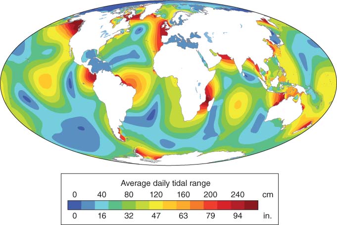
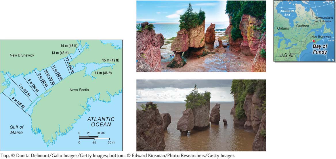
In some regions, tides are barely noticeable, while in others, their effects dominate the coastline. The average tidal range on Earth is 100 cm (36 in). The world’s greatest tidal range occurs in the Bay of Fundy in eastern Canada (Figure 19.5), where the maximum tidal range is 16.8 m (55 ft).
Coastal Waves
Waves result as wind energy is transferred to the ocean’s surface by friction. If there were no wind, the oceans would be glassy smooth. Only infrequent wave-
As waves move across the surface of the open ocean, they give the appearance that the water is flowing, but that is not the case. A floating object on the ocean’s surface, such as a bottle, moves in a circular pattern as the waves pass beneath it. The bottle does not move forward horizontally with the waves. Individual water molecules, like the bottle, trace a circular path. Waves that cause this circular movement are called waves of oscillation.
waves of oscillation
Waves in which water moves in a circular path.
Because most waves are organized in long ridges, the rotating circles in a wave of oscillation are better pictured as connecting together to form long cylinders. The radius of the topmost cylinder at the surface is equal to the wave height. Waves are composed of a series of cylinders that are stacked vertically. With increasing depth, the diameter of the cylinders decreases. The movement of water ends at the wave base, at a depth equal to about three-
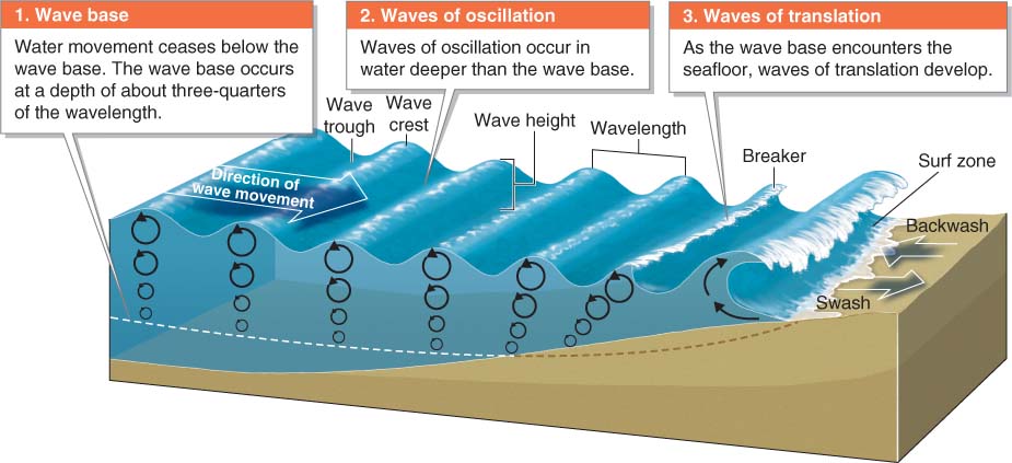
In the open ocean, wave height depends on the speed of the wind, the duration of the wind, and the fetch: the distance of open water over which the wind blows. Slow winds over a short fetch, such as an inland lake, produce small waves. Fast and sustained winds blowing over the open ocean with a long fetch generate large waves with long wavelengths, called swells. Swells, which are generated only in the open ocean, can have wave heights of 2 to 10 m (6 to 33 ft) or more and wavelengths of 40 to 500 m (130 to 1,600 ft) or more.
fetch
The distance of open water over which wind blows.
As a wave approaches the coastline, the wave base comes in contact with the seafloor (see Figure 19.6). As the wave continues into shallower water, friction with the seafloor slows the base more than the top and as a result the wave crest grows higher. The wave crest also travels faster than the wave base, causing the wave to shear in an elliptical motion. In this type of wave, called a wave of translation, water does move forward horizontally in the direction of wave movement. Eventually, the wave crest collapses, forming a breaker (see Figure 19.6).
wave of translation
A wave in which water moves forward in the direction of wave movement.
On a beach, breakers form in the surf zone. As breakers collapse on themselves in their forward momentum, they create a swash: a rush of water up a beach. The slope of the beach will limit how far the swash can travel up the beach. The water flows back down the beach as backwash and returns to the ocean.
swash
The rush of water up a beach following the collapse of a breaker.
backwash
The flow of water from breakers down the slope of a beach back toward the ocean.
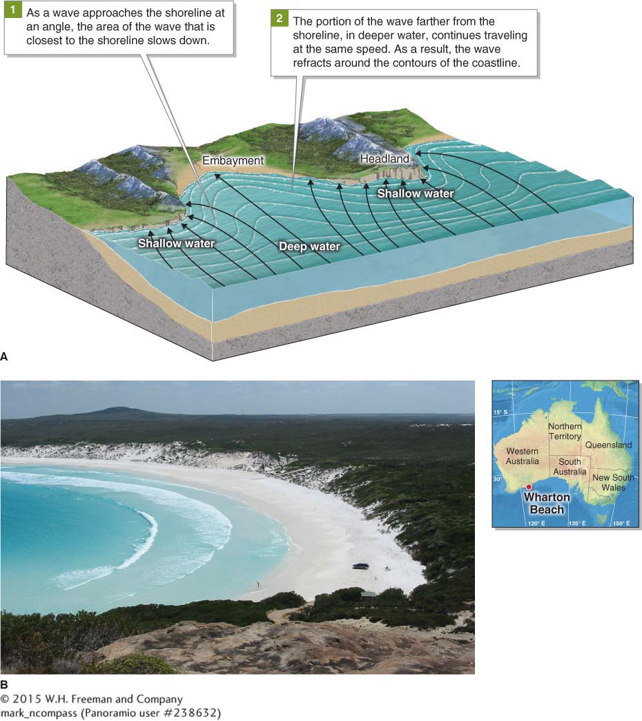
As waves approach the shoreline, they bend so that their orientation is roughly parallel to the shoreline. This process is called wave refraction. Even where the coast is uneven, with rocky prominences called headlands and concave sandy beaches called embayments, waves refract around the headlands and maintain a mostly parallel approach to the shoreline (Figure 19.7).
wave refraction
The process in which waves approaching the shoreline bend and maintain a nearly parallel orientation to the shore.
headland
A rocky prominence of coastal land.
embayment
A concave sandy beach between headlands.
Coastal Currents
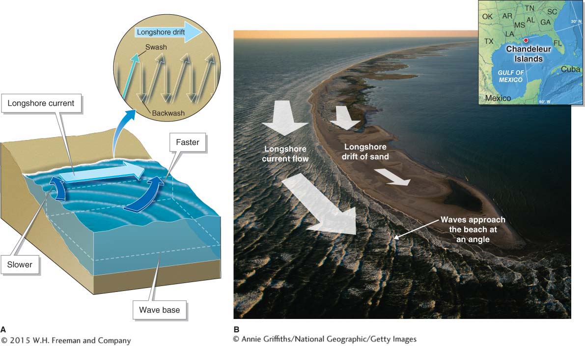
Although wave refraction causes waves to approach a beach nearly parallel to the shoreline, most wash ashore at a slight angle. This angled approach of waves creates a longshore current, which flows parallel to the beach in the direction of wave movement. Longshore drift is the movement of sediment down the length of the beach in the direction of wave movement (Figure 19.8). The longshore current and longshore drift transport sand, both on the beach and beneath the water in the surf zone. The surface layers of the sand are always moving down the length of the shore.
longshore current
A current that flows parallel to the beach in the direction of wave movement.
longshore drift
The process by which sediment on a beach is moved down the length of the beach in the direction of wave movement.
Animation
Longshore drift http:/
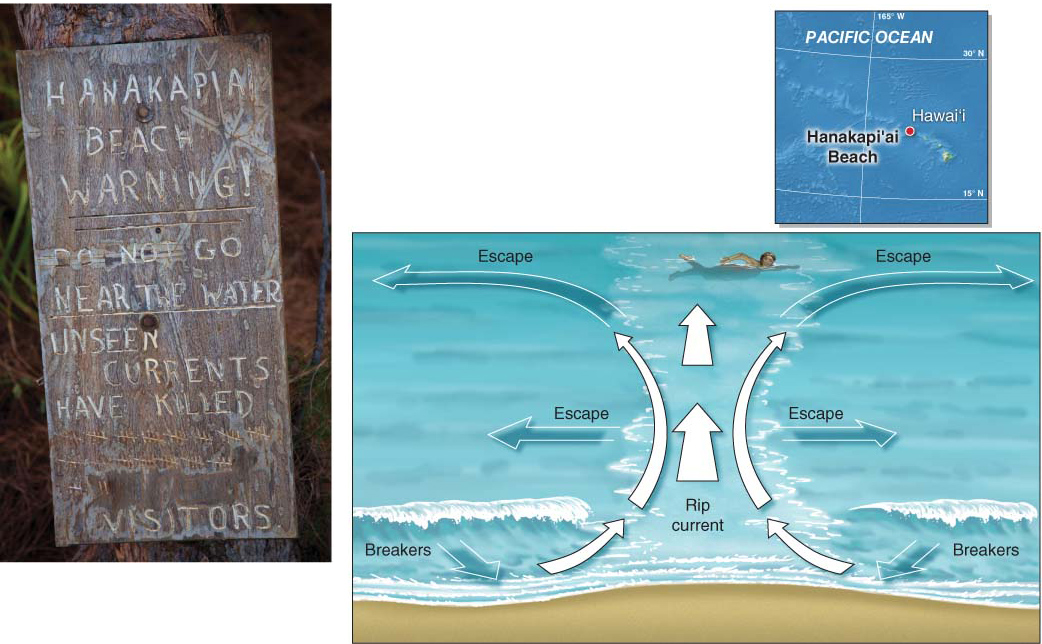
Picture This discusses rip currents, short-
rip current
A short-
Question 19.2
What are rip currents and why are they deadly?
A rip current is a narrow jet of backwash leaving the beach. Swimmers who get caught in a rip current can be swept out to sea.
Picture This
Rip Currents
Hanakapi‘ai Beach, on the island of Kaua‘i, is marked with a sign warning visitors to avoid the water due to rip currents. An ominous running tally of fatalities is marked on the sign.
Rip currents are caused when breakers converge and the backwash flows into the sea at a focused point, usually where a trench occurs between submerged sandbars. Rip currents can form at any time, but they are most likely to form when wave heights are at a maximum. They range in width from a few meters to hundreds of meters. Some rip currents disappear at the breakers, but others may continue for hundreds of meters beyond the surf zone.
Rip currents do not pull people underwater. Instead, they carry people away from shore. Even the strongest swimmers may drown when they become too exhausted to swim back to safety. In the United States, about 150 people drown in rip currents each year. If you are caught in a rip current, the best strategy is to swim parallel to the beach to get out of the current, rather than trying to fight it by swimming toward the beach.
Consider This
Question 19.3
What causes a rip current?
Question 19.4
What is the best thing to do if caught in one?