9.1 The Living Veneer: Soils
Describe how soils form and erode, and explain why soils are important to people.
Soils are a fundamentally important natural resource. Soil is the layer of sediment closest to Earth’s surface that has been modified by organisms and water, and it is the region of the lithosphere into which plant roots extend. The gateway for solar energy entering the terrestrial biosphere, as we have seen, is plant photosynthesis, and almost all land plants are rooted in soil. Without soil, there would be no plants and little life on land.
soil
The layer of sediment that has been modified by organisms and water; the region of the lithosphere into which plant roots extend.
Even marine ecosystems are tied to soils. Marine phytoplankton (see Section 7.5) use nutrients derived from stream runoff and windblown dust from the continents as well as nutrients (or sediments) stirred up from the seafloor.
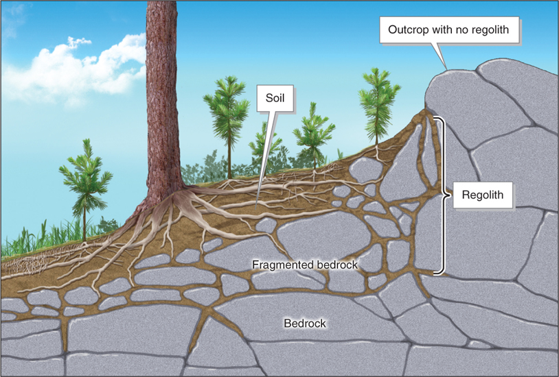
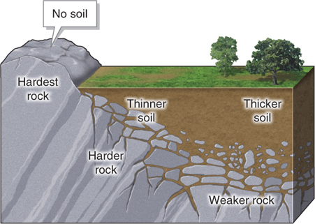
Pedogenesis, the process of soil formation, occurs through the weathering of rocks, the activities of organisms, the movement of rainwater, and time. Soils form as weathering breaks down bedrock into smaller fragments. Bedrock is rock that is structurally part of and connected to Earth’s crust. Any loose Earth material that covers bedrock is called regolith (Figure 9.2).
pedogenesis
The process of soil formation.
bedrock
Rock that is structurally part of and connected to Earth’s crust.
regolith
Any loose, fragmented Earth material that covers bedrock.
Soil Characteristics
Most soils, when exposed in a soil profile (or cross section), have several distinct layers, or horizons. Soil horizons are horizontal zones within the soil that are identified by their different physical and chemical properties. Weathering and the activities of organisms create soil horizons. In addition, rainwater carries soil particles downward through the process of eluviation. Rainwater also carries dissolved nutrients downward through the process of leaching. In the process of illuviation, particles and minerals are deposited deeper in the soil. Both eluviation and leaching are important in the development of soil horizons, as shown in Figure 9.3.

soil horizon
A horizontal zone within the soil identified by its chemical and physical properties.
eluviation
The process by which rainwater carries soil particles downward.
leaching
The process by which rainwater carries dissolved nutrients downward.
Most soils contain components from all four of Earth’s major physical systems: rock fragments and minerals (lithosphere), water (hydrosphere), air (atmosphere), and organic material (biosphere). Although no two soils are alike, most soils are composed chiefly, by volume (but not by weight), of rock fragments, minerals, and air.
Soil is often described by its texture, which is determined by the relative amounts of sand, silt, and clay composing it. Sand, silt, and clay are inorganic soil particles of three size classes (Figure 9.4). Soil textures can be summarized graphically in a soil texture triangle (Figure 9.5).

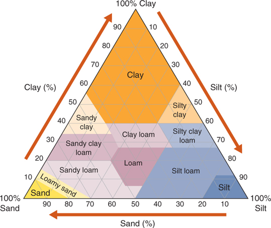
One soil type particularly important to people is loam. Loam has a mineral content of about 40% sand, 40% silt, and 20% clay and contains large amounts of organic material. Farmers value loam because it retains and transmits moisture and nutrients that are easily accessible to plants. Sandy soils and rocky soils are dominated by mineral particles and have low organic content. Large pores (or air spaces) between particles allow water to drain from sandy and rocky soils rapidly, and nutrients are quickly leached out of reach of plants. As a result, they make poor agricultural soils. The opposites of sandy and rocky soils are clay soils and silt soils. Clay and silt particles are extremely small and impede water flow, which makes these soils unsuitable for many plants. Loam is the ideal soil texture for growing crops.
loam
Soil that consists of approximately 40% sand, 40% silt, and 20% clay and has a high organic content.
Soil Formation Factors
Many different factors help to determine what types of soils will form in any given place and how fast they will form.
Climate
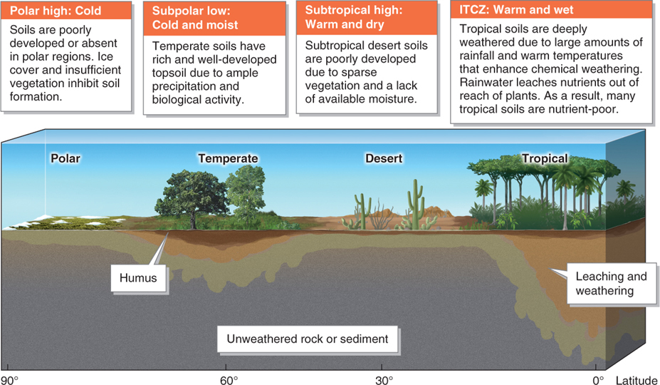
Temperature, rainfall, and even the types of organisms living in and affecting the soil are a function of climate. Soil develops most quickly where chemical weathering (the chemical disintegration of rocks) predominates, such as in the lowland tropics, where it is always warm and moist. Soil develops more slowly in cold climates and in arid climates. As Figure 9.6 shows, soil types and soil development coincide with the broad latitudinal climate zones determined by global atmospheric pressure systems (see Section 4.3).
Parent Material
A soil’s parent material is the rock and mineral matter that is weathered into particles of sand, silt, and clay. Parent material is composed of both the weathered bedrock beneath the soil and regolith that has been transported to the site by streams, glaciers, or wind. The type of parent material, which may be granite, basalt, sandstone, or even volcanic ash, plays a part in the chemical composition of the soil, the texture of the soil, and the rate at which soil can form (Figure 9.7).
Question 9.1
What is the difference between dirt and soil?
Dirt is what we track into the house on our shoes. Soil is the living medium in which we grow our food.
Organisms
“Dirt” is what we track into the house. Soil is the living medium in which we grow our food. Healthy soil is a teeming metropolis of worms, insects, and microbes that churn and digest organic material. Without the effects of biological activity, broken bedrock would simply be sterile regolith, composed of gravel and sand, like that found on the Moon or Mars.
The topmost layer of soil, the O horizon, is composed primarily of partially decomposed vegetation such as leaf litter. Just below the O horizon is the A horizon, also called topsoil. The A horizon is thin—
Soil horizons O and A are strongly influenced by the activities of organisms (see Figure 9.3C). Seeds and plant roots are concentrated in these horizons. Microbes, nematodes, earthworms, beetles, and other insects all digest, bioturbate (mix), and build soil. Bioturbation redistributes nutrients and particles throughout the A horizon. Wastes from these organisms and from larger animals also contribute to the chemical and physical structure of these horizons. Soil organisms create humus, the brownish-
humus
(pronounced HYOU-
On a local level, people can play an important role in soil development. There are many examples of organic-
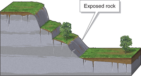
Topography and Moisture
The steepness of a slope is directly related to the depth of soil that can develop there. Less regolith accumulates on steeper slopes because gravity pulls it down to low-
Within a climate zone, aspect (the direction in which a slope is facing) controls soil moisture. In the Northern Hemisphere, for example, south-
Time
Inputs of new inorganic material and biological activity build and renew soils over time. The average thickness of Earth’s soils is only about 1 m (3.3 ft). Soils develop at a rate of 2.5 cm (1 in) per 200 to 1,000 years. Anthropogenic soils, on the other hand, can be formed in less than a year.
Question 9.2
How long does it take for soils to form?
People can compost food scraps into soils in a matter of months. Natural soil formation occurs at a rate of a few centimeters per century.
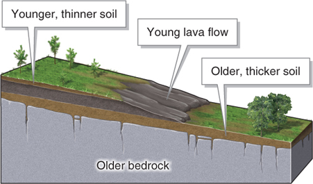
As we have seen, soil formation takes longer in cold climates than in warm climates. In addition, it takes much longer to form soil from bare rock than from sediments such as sand. As Figure 9.10 illustrates, older rock surfaces are generally covered by thicker soils.
Soil Erosion
The National Academy of Sciences estimates that, as a general trend, the world’s croplands are losing soil at a rate 10 to 40 times faster than soil can form naturally. Worldwide, an area of cropland roughly the size of Indiana is significantly degraded or lost every year (about 10 million ha, or 25 million acres). The most important factor in soil loss and degradation is erosion by water runoff and wind. Other causes of soil loss include poor agricultural practices, roads, settlements, and poisoning with pesticides and herbicides.
CRUNCH THE NUMBERS: Calculating Soil Loss
CRUNCH THE NUMBERS: Calculating Soil Loss
Parts of Iowa have experienced net rates of soil loss as fast as 0.1 cm (0.04 in) per year over the last 150 years.
To calculate total soil loss, multiply the annual rate of loss by years.
Question 9.3
How much topsoil has been lost in the last century and a half in parts of Iowa?
Question 9.4
If farmers slowed the rate of soil loss to half the rate above, how much soil would be lost in the next 100 years?
Valuable topsoil is the first to be eroded away because of its position at the soil surface. Erosion can also change soil texture. Finer particles, such as silt and clay, erode before heavier particles, such as sand. Loam, for example, can be become sandy soil if its silt and clay are blown away.
Soil erosion can occur rapidly in a single heavy downpour, or it can happen gradually and imperceptibly over long periods. Either way, soil will be lost if soil erosion exceeds the rate of soil formation. Crunch the Numbers asks you to calculate annual rates of soil loss in Iowa.
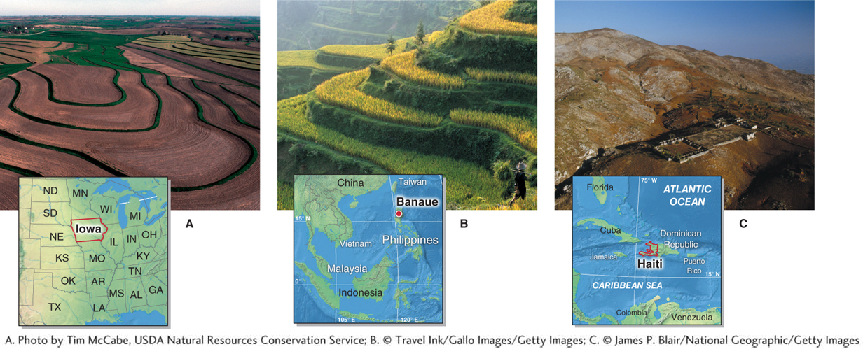
Two widespread factors contribute to soil erodibility: the removal of vegetation and poor agricultural practices. First, plant roots anchor soil. When plant cover is removed, the soil becomes prone to erosion by moving water and wind. Deforestation, overgrazing, fire, and plowing are a few of the factors that remove anchoring plant roots. Poor agricultural practices, such as leaving the soil unplanted and exposed to wind and flowing water, also lead to soil erosion (Figure 9.11). Bare soils without protection by crops or crop residue are prone to erosion. In addition, compaction of soil layers by heavy machinery can decrease the pores in soil into which water can seep, leading to greater surface runoff and faster erosion.
When steep slopes are farmed, they can experience severe soil erosion. To reduce erosion, contour plowing and terracing can be employed (Figure 9.12).
Naming Soils: Soil Taxonomy
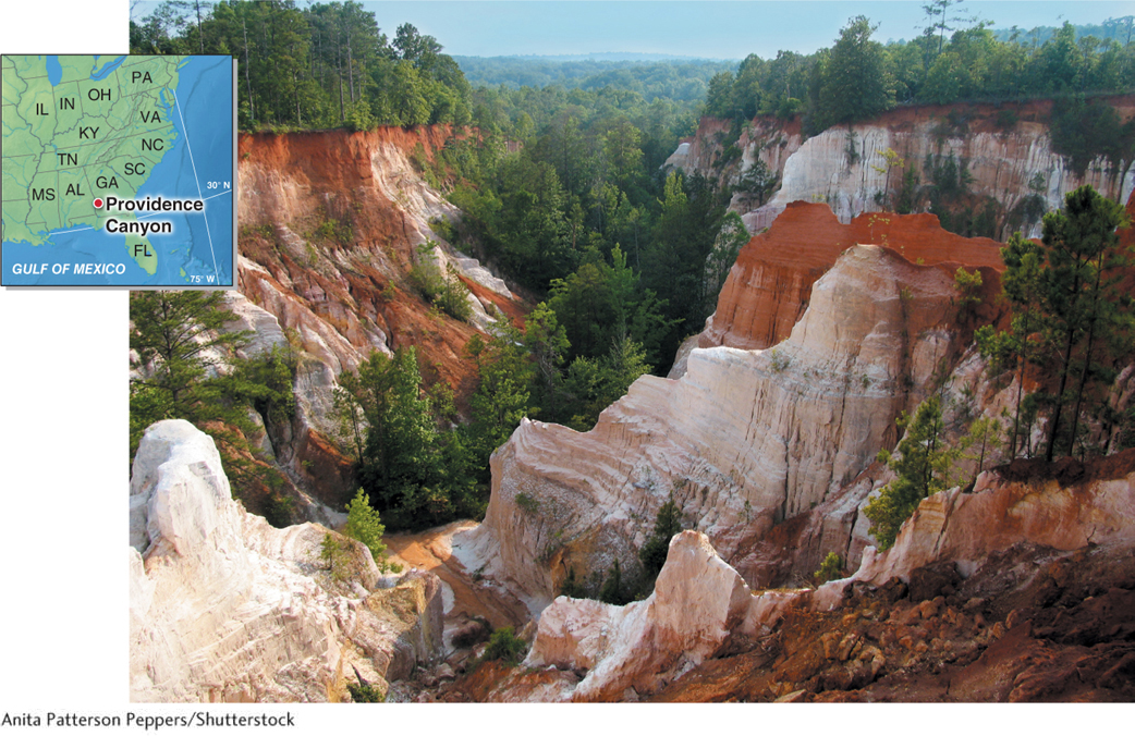
Many localities are named after the color of their dominant soils: the Yellow River (Huang He) of China, the Red River between Oklahoma and Texas, the White Sands of New Mexico, the Painted Desert of Arizona, and the Kemet or “black soils” of the Nile Delta in Egypt.
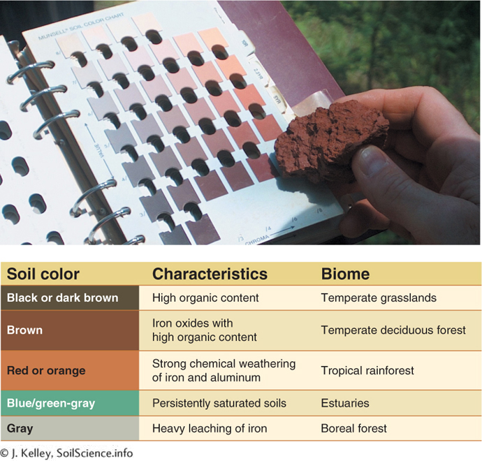
Color and horizon development are used to classify and name soils. Soil color reveals the soil’s history and the conditions under which it formed, as well as its composition. The Munsell Soil Color Book, shown in Figure 9.13, is widely used among soil scientists as a means to identify soil types based on their colors.
In biology, scientists use the Linnaean taxonomic system to name organisms. Similarly, the Köppen system classifies climates. Scientists use several different systems to classify soils. Canada, for example, uses a system called the Canadian System of Soil Classification. One soil classification system that is widely used in the United States, called soil taxonomy, groups soils into 12 soil orders, as shown in Figure 9.14.
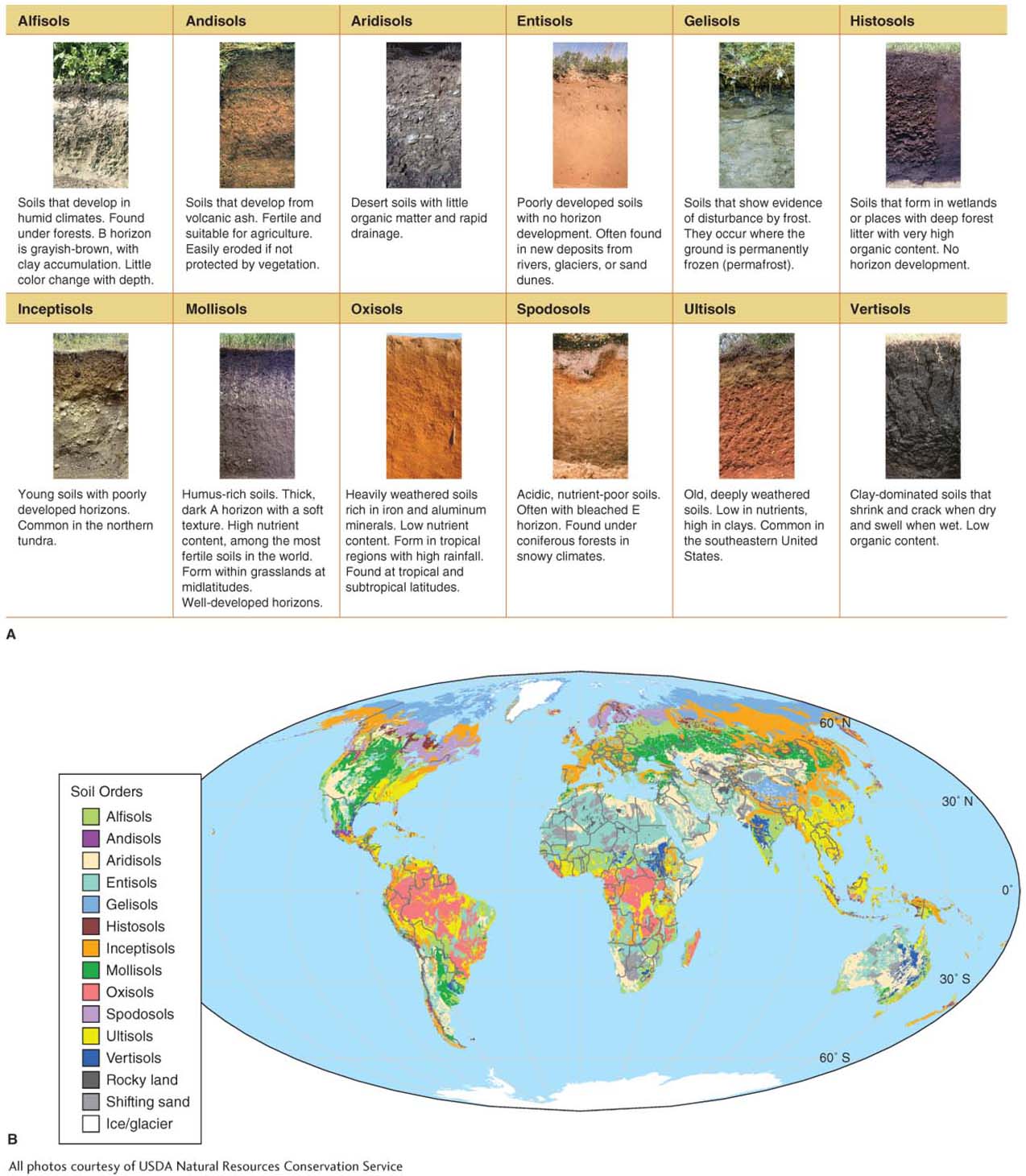
soil taxonomy
A soil classification system that groups soils into 12 categories, or orders.
The Importance of Soils to People
Soils are essential to life, both on land and in the oceans. They are essential to humans as the medium in which we grow most of our food. This section explores some of the other ecosystem services that soils provide.
Medicines
Scientists have learned much from the chemicals that soil bacteria make. Among the first naturally occurring antibiotics used in the treatment of human diseases was tyrothricin (or gramicidin), which was isolated from soil bacteria in 1939. The Actinobacteria, a widespread group of soil bacteria, have been used to make more than 20 different antibiotic compounds. The antibiotics actinomycin, neomycin, and streptomycin are in widespread commercial use today and have saved countless human lives.
Mitigation of Climate Change
Soils contain enormous amounts of organic material and, therefore, large amounts of carbon. Terrestrial carbon stocks in the soil are greater than those in living biomass (plants). The boreal forest contains by far the greatest amount of carbon in its soils. Table 9.1 gives the global carbon stocks in various vegetation types, sorted by soil carbon amounts.
|
VEGETATION TYPE |
SOIL CARBON (PG C)* |
PLANT CARBON (PG C) |
TOTAL CARBON (PG C) |
|---|---|---|---|
|
Boreal forest |
471 |
88 |
559 |
|
Temperate grasslands |
295 |
9 |
304 |
|
Tropical savanna |
264 |
66 |
330 |
|
Wetlands |
225 |
15 |
240 |
|
Tropical rainforest |
216 |
212 |
428 |
|
Desert |
191 |
8 |
199 |
|
Cropland |
128 |
3 |
131 |
|
Tundra |
121 |
6 |
127 |
|
Temperate forest |
100 |
59 |
159 |
|
*1 Pg C (petagram of carbon) − 1015 g of carbon (2.2 trillion lb). |
|||
When carbon is exposed to the air, it oxidizes (reacts with oxygen) to form the greenhouse gases carbon dioxide and methane. Any changes in the vegetation cover that holds soil in place can result in oxidation of soil carbon, which forms carbon dioxide that enters the atmosphere. Deforestation and changes in land use that result in soil disturbance and loss are directly linked to oxidation of soil carbon. Such changes have contributed about 20% to the climate warming of the last century (see also Section 6.4).
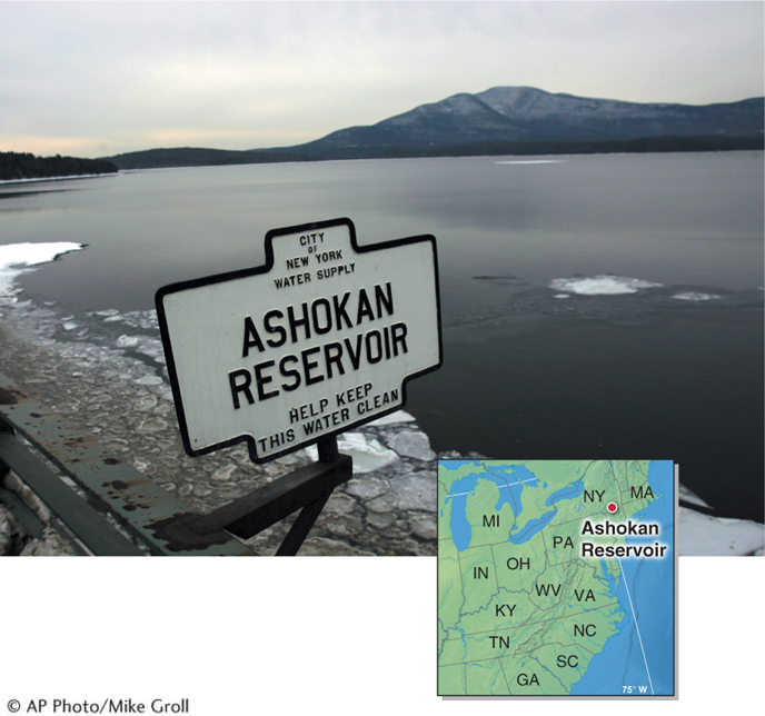
Water Purification
Up until about the 1980s, New York City’s water supply, located in the Catskill Mountains, was filtered by vegetation and soils. New York’s water was nicknamed “the champagne of drinking water” in reference to its purity. The city’s water supply began to be polluted in the 1980s, however, due to increasing construction of vacation homes near streams, building of new roads, and poor agricultural practices in the Catskills. Rather than constructing a costly water filtration plant to clean the water, the city took land in the Catskills through eminent domain. It allowed forest to return and soils to develop to filter the water in its reservoirs naturally, as they had the past (Figure 9.15). A water filtration plant would have cost up to $8 billion (plus $300 million in yearly maintenance costs) compared with the roughly $1.5 billion it cost the city to buy land. Some 830,000 ha (2 million acres) of temperate deciduous forest was allowed to return to the Catskills to filter and clean the water naturally.