17.3 Carving by Ice: Glacial Erosion
Explain how glaciers cut into rocks and identify landforms caused by glacial erosion.
Erosion by glaciers is less geographically widespread than erosion by streams. Where they occur, however, glaciers exert a powerful erosive force and are capable of grinding down and wearing away even the hardest of bedrock. Even in the tropics, as mountain ranges are uplifted through geologic time, they enter colder reaches of the troposphere where glaciers can form. As the glaciers begin flowing, they grind away at the mountains—
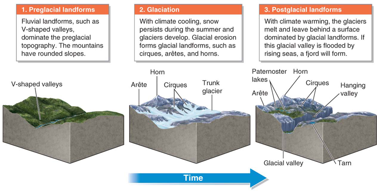
Many of Earth’s most spectacular landforms were carved during the last glacial maximum (see Section 6.2). With natural climate warming, those glaciers have melted away, but they have left behind their mark of erosion.
Grinding Rocks: Plucking and Abrasion
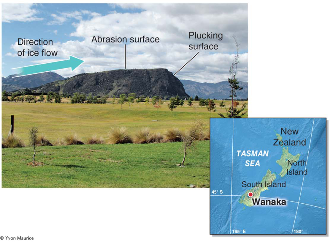
Flowing glaciers cut into bedrock through plucking and abrasion. Plucking is the process by which a glacier pulls up and breaks off pieces of bedrock as it moves downslope. Abrasion, as we saw in Section 16.2, is the process by which movement of one material wears away another material.
plucking
The process by which a glacier pulls up and breaks off pieces of bedrock as it moves downslope.
When meltwater accumulates at the base of a glacier, then refreezes around protrusions in the bedrock, it allows the glacier to pull loose, or pluck, fragments of bedrock. The ice grabs the bedrock and pulls it up, much as you would pull a staple out of paper with a staple remover. Fragments of bedrock ranging from siltsized particles to massive boulders become embedded in the base of the glacier as a result of glacial plucking.
Question 17.6
How does the soft ice of a glacier carve into solid bedrock?
With rock fragments frozen into its base, a flowing glacier can cut into the hardest of bedrock like rough sandpaper sanding soft wood.
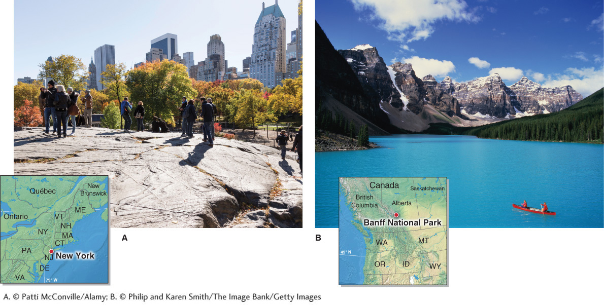
As a glacier flows downslope, the rock fragments that have been plucked and embedded in its base grind against the bedrock much like sandpaper sanding wood. Grooves gouged into the surface of bedrock by glacial abrasion are called glacial striations. Often, a smoothed surface called glacial polish forms on the bedrock over which the glacier flows (Figure 17.17A). Glacial abrasion pulverizes rock into a fine powder called glacial flour. When this powder is suspended in water, it can color the water bright turquoise or cyan (Figure 17.17B).
glacial striation
A groove gouged into the surface of bedrock by glacial abrasion.
glacial polish
A smoothed bedrock surface resulting from glacial abrasion.
Transporting Rocks: Ice and Glacial Streams
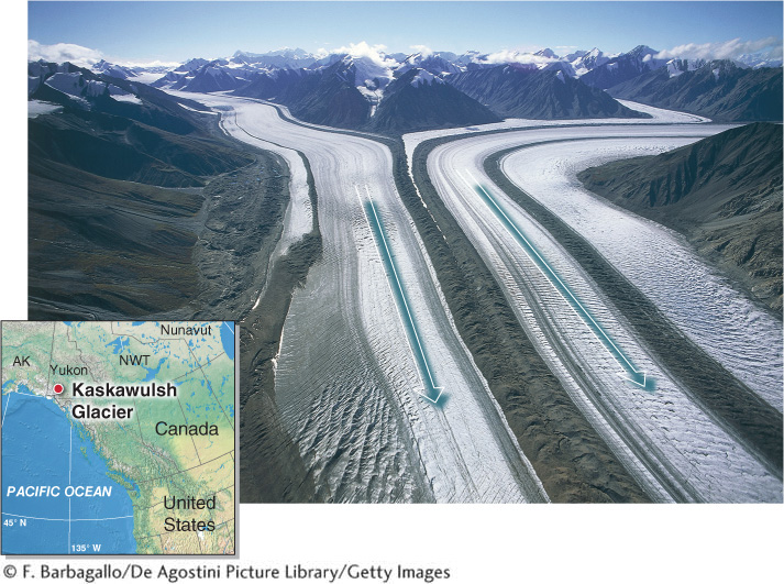
Most glaciers carry rock debris that has fallen on them through mass movement of overlying slopes as well as rock fragments they have picked up through plucking. As Figure 17.18 shows, rocks on glaciers and rocks embedded within them are transported downslope by the moving ice. Flowing glaciers are like conveyor belts that move ice and rock debris downslope. Rock material can be transported all the way to the toe of the glacier, where it is deposited in piles of unsorted sediments called moraines (see Section 17.4).
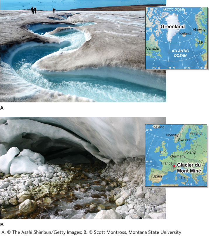
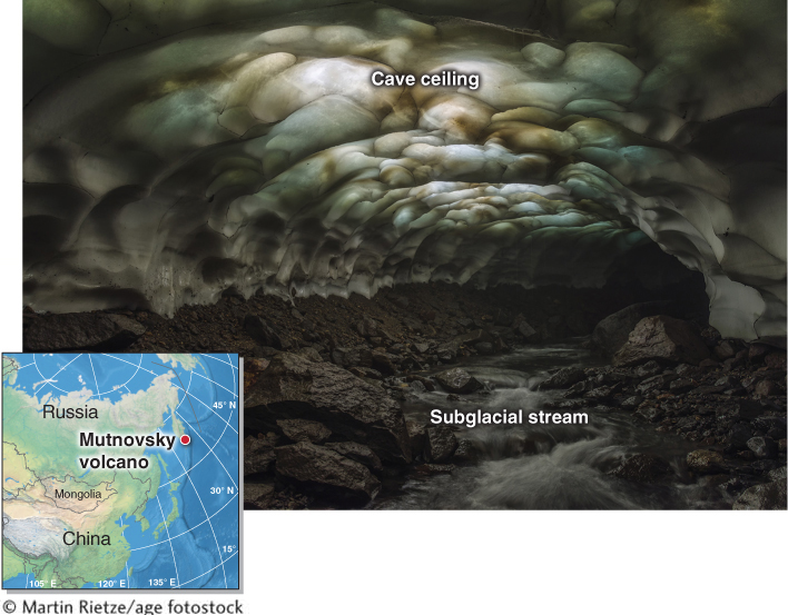
In summer, a glacier produces streams of meltwater that flow over the surface of the glacier (called supraglacial streams), inside the glacier in tunnels, and beneath the glacier between its base and bedrock (called subglacial streams) (Figure 17.19). Subglacial streams transport glacial sediments downslope. Much like streams that form deltas, subglacial streams exiting a glacier (called outlet streams) form a flat outwash plain as the sediments they carry accumulate (see Figure 17.20). Because of their heavy sediment loads, streams on outwash plains are typically braided (see Section 16.3). Outwash plains are examples of glaciofluvial landforms, meaning that both flowing ice and flowing water combine to create them.
outwash plain
A flat area of sediments deposited by glacial outlet streams.
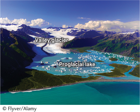
Proglacial lakes (meaning lakes “in front of” the glacier) form at the toe of a glacier where a depression has been excavated by the ice or where sediments dam an outlet stream (Figure 17.20). Proglacial lakes are becoming more common as valley glaciers and outlet glaciers retreat upslope in response to the atmospheric warming of the last century.
Picture This
A Lighted Ice Tunnel
This photo, taken in September 2012, shows a remarkable subglacial stream inside a glacier on Mutnovsky volcano on the Kamchatka Peninsula in Russia. Normally, subglacial stream tunnels are pitch black because light cannot pass through the thick glacial ice above. In this photo, however, the stream’s ice tunnel is illuminated by outside light passing through the ceiling’s thin ice. The patterns in the ceiling result from the way the ice has melted. Most of Kamchatka’s glaciers have a negative mass balance and are thinning. If the ceiling of this subglacial tunnel continues thinning, the tunnel will eventually collapse.
Consider This
Question 17.7
What is unusual about this subglacial stream’s tunnel?
Question 17.8
How does this tunnel relate to climate change?
Subglacial streams excavate tunnels through the ice. The ceilings of these tunnels sometimes become thin enough for light to pass through. As Picture This shows, when this happens, the interior of the glacier becomes illuminated, resembling stained glass.
Erosional Landforms
Glacial geomorphology is the study of landforms created by glaciers. Understanding how glaciers influence a landscape is important for understanding and describing the development of a region’s topography and its climate history. In the remainder of this section, we explore landforms created by glacial erosion, starting with those that form in high-
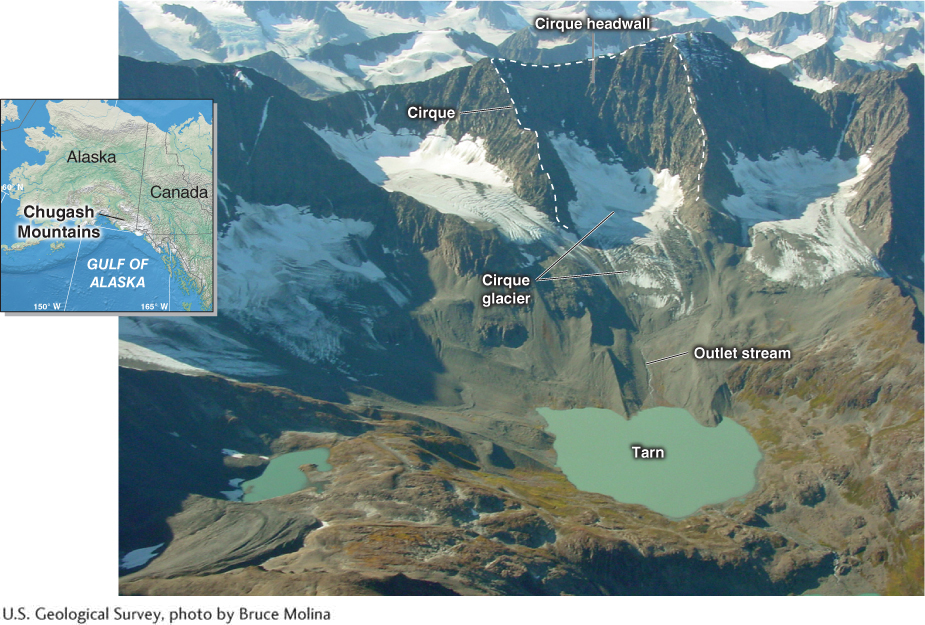
Cirques and Tarns
Cirques and tarns are often found at the highest elevations in mountain ranges. A cirque is a bowl-
cirque
A bowl-
tarn
A mountain lake that forms within or just below a cirque.

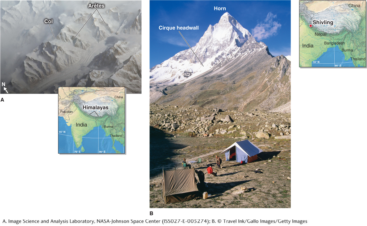
Arêtes, Cols, and Horns
Where glaciers erode opposite sides of a mountain, a sharp, steep-
arête
(pronounced ar-
col
A low area or pass over a ridge formed by two cirque glaciers.
horn
A steep, pyramid-
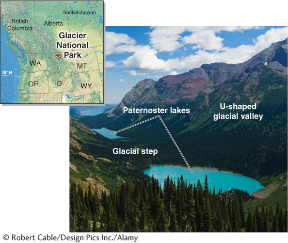
Glacial Valleys and Paternoster Lakes
As we learned in Section 16.2, a stream’s energy is focused on its narrow stream channel. As a result, streams cut V-
glacial valley
(or glacial trough) A U-
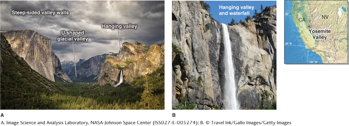
Like trunk streams and tributary streams (see Section 16.1), trunk glaciers have a larger ice volume than tributary glaciers. As a result, they have more erosive power and cut deeper into the bedrock. The surface heights of trunk and tributary glaciers, however, are equal. After the glaciers have melted, a hanging valley is left where a tributary glacial valley feeds into a larger glacial valley with a deeper valley floor, as shown in Figure 17.23.
Question 17.9
How did Yosemite Valley form?
Yosemite Valley was formed as a valley glacier cut into the granite bedrock, forming a deep U-
Relatively resistant portions of bedrock and ridges of debris called recessional moraines (discussed further in Section 17.4) sometimes form obstructions to stream flow, called glacial steps, along the floor of a glacial valley. A small lake may form behind each of these steps. Lakes that form in this way are called paternoster lakes (from Latin, meaning “our father,” in reference to their similarity to religious rosary beads) (Figure 17.24).
paternoster lake
One of a series of small lakes that form behind glacial steps in a glacial valley.
Also found on the floors of glacial valleys are protruding outcrops of bedrock called roches moutonnées (derived from the French mouton, for their resemblance to fleecy sheep). A roche moutonnée is an elongated and asymmetrical ridge of glacially carved bedrock (Figure 17.25).
roche moutonnée
(pronounced ROSH moo-
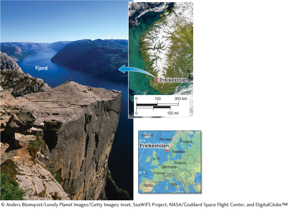
Drowned Glacial Valleys: Fjords
Many high-
fjord
A U-
Climate and Glacial Landforms
Latitude and elevation are important factors that determine whether glaciers will develop in a region and give rise to landforms like those we have explored in this section. Ultimately, climate controls the growth of glaciers in any given region. Like fluvial landforms (described in Chapter 16), glacial landforms develop through time as climate changes (Figure 17.27).