19.2 Coastal Landforms: Beaches and Rocky Coasts
Describe landforms on beaches and rocky coasts and explain how they form.
The tectonic setting plays an important role in determining what kind of shoreline forms in any given region. Plate movements can lift or lower Earth’s crust. At active continental margins near convergent plate boundaries (see Section 12.3), the converging plates compress the crust and raise it. Similarly, the weight of sediments or ice sheets (see Section 6.2) can depress the crust; if this weight is removed, the crust will rebound upward through isostasy. Isostasy is the gravitational equilibrium between the lithosphere and the support of the asthenosphere below.
isostasy
The gravitational equilibrium between the lithosphere and the support of the asthenosphere below.
When a coastline lifts to higher elevation, an emergent coast forms. An emergent coast is one where sea level is dropping or the land is rising. Emergent coasts are dominated by erosional landforms such as steep cliffs and rocky shorelines. The west coasts of North and South America, for example, are tectonically active emergent coasts with rocky shorelines. The emergent coast of eastern Canada is rising because the weight of the Laurentide ice sheet is gone.
emergent coast
A coast where sea level is dropping or the land is rising.
Most plate boundaries do not coincide with continental margins. Instead, a single lithospheric plate holds both a continent and a coastal plain that extends beneath the sea as a flat, gently sloping continental shelf (see Section 10.1). These passive continental margins are often submergent coasts, where the land surface is subsiding. Submergent coasts are dominated by depositional landforms such as beaches and coastal wetlands. The southeastern United States and Gulf Coast, for example, have gentle slopes with sandy beaches and coastal wetlands.
submergent coast
A coast where sea level is rising or the land is sinking.
Sea level can also change without raising or lowering of the lithosphere. About 15,000 years ago, during the most recent glacial period, sea level was 85 m (280 ft) lower than it is today because so much water was frozen on land in ice sheets (see Section 6.2). When the glacial period ended, the meltwater from these ice sheets raised sea level by 85 m. Change in global sea level as a result of change in the amount of water in the oceans is called eustasy.
eustasy
A change in global sea level as a result of change in the amount of water in the oceans.
Either way, an emergent coast occurs where sea level falls (through eustasy) or where the coast is lifted (through isostasy). Likewise, a submergent coast occurs where sea level rises (eustasy) or where the coast sinks (isostasy).
Other important factors that control the morphology of a coast are the amount of wave energy reaching it, the presence of biogenic structures such as coral reefs, the tidal range, and the amount and type of sediment that is available. Table 19.1 groups coasts into five main categories. In this section, we discuss two of the most common types of coasts: beaches and rocky coasts.
|
TYPE OF COAST |
DESCRIPTION |
TEXT REFERENCE |
|---|---|---|
|
1. Depositional coasts: Beaches and deltas |
|
|
|
Beach |
Sand- |
|
|
Barrier island |
Sand- |
|
|
Delta |
Formed at river mouths |
|
|
2. Erosional coasts: Rocky shorelines |
|
|
|
Bedrock |
Found anywhere bedrock is exposed to coastal wave energy |
|
|
Limestone karst |
Various settings; common in Caribbean islands and in Croatia |
|
|
Lava flow |
Various settings; found on Hawai‘i |
|
|
3. Organic coasts |
|
|
|
Coral reef |
Dominated by living reefs; restricted to the tropics and subtropics |
|
|
Mangrove |
Dominated by mangroves; restricted to the tropics and subtropics |
|
|
Estuary |
Formed where freshwater meets salt water at river mouths |
|
|
Anthropogenic |
Includes any coast that has undergone significant modification by human activities |
|
|
4. Flooded coasts |
|
|
|
Ria |
Drowned V- |
|
|
Fjord |
Drowned U- |
|
|
5. Ice coasts |
|
|
|
Glaciers and ice shelves |
Generally found at latitudes higher than 55 degrees |
|
|
Glacial sediments |
Found where continental ice sheets deposited glacial sediments; common in northeastern Canada and northern British Isles |
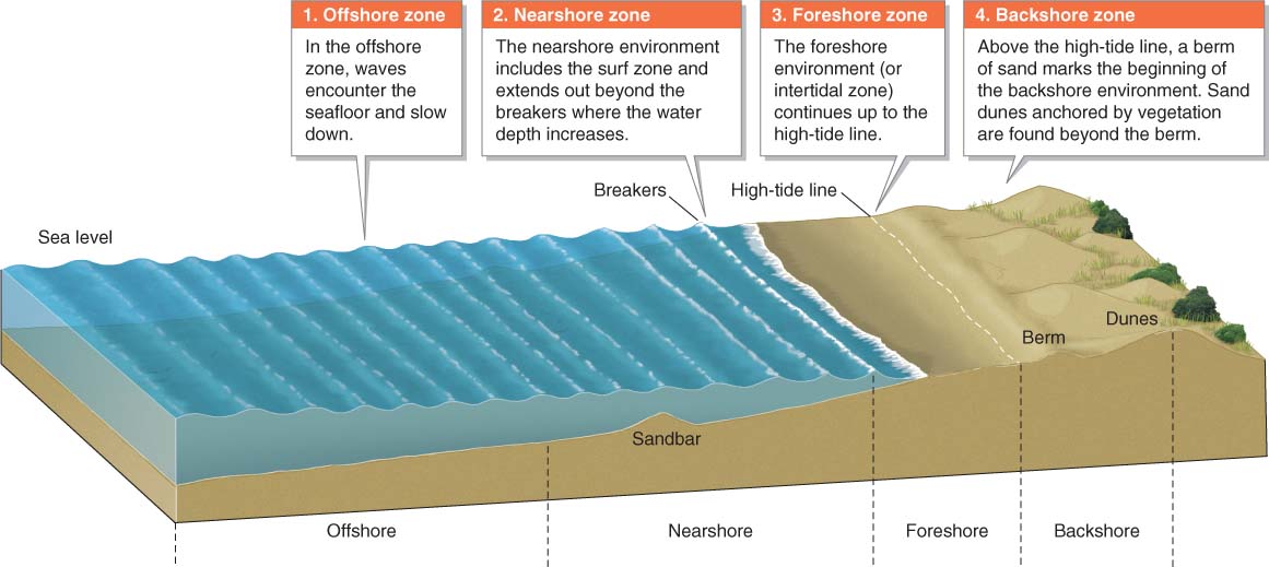
Beaches
Beaches consist of an offshore zone, nearshore zone, foreshore zone (or intertidal zone), and backshore zone, as illustrated in Figure 19.9. Waves that break on the gentle slope of a beach have less energy than those that break on a rocky coast. As waves move toward the beach, the base of each wave makes contact with the seafloor in the nearshore zone. As a result, the wave’s energy is reduced as it works to transport sediments on the seafloor before encountering the foreshore zone.
Question 19.5
Why are some beaches black?
The color of a beach is determined by the type of sediments from which it forms. Most black beaches are composed of particles of basalt.
Beaches vary in the composition of their sediments, depending on the source of the sediments. Tan and beige beaches of quartz are the most common because quartz is particularly resistant to weathering and erosion and persists for a long time (see Section 15.1). Not all beaches are composed of quartz sand, however. Weathering and erosion of coral reefs results in brilliant white beaches consisting of broken fragments of reef-
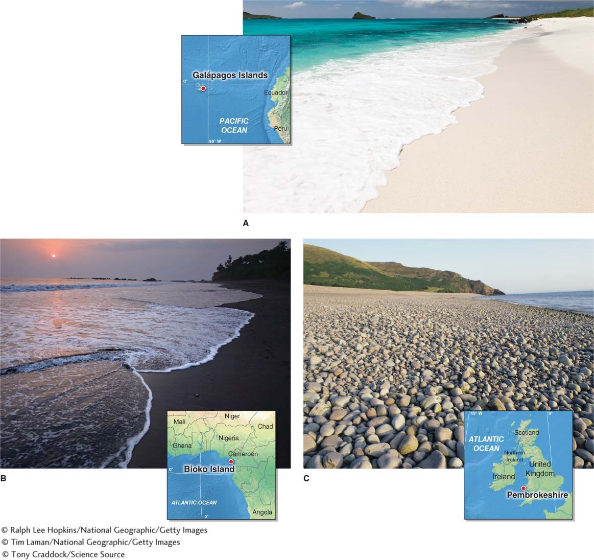
Nor are all beaches composed of sand. Where weathering and mass movement of nearby cliff faces are occurring, larger particles, such as gravel or cobbles, will form a shingle beach (Figure 19.10C).
shingle beach
A beach composed of sediment particles larger than sand, such as gravel or cobbles.
Beach Landforms
Beaches are like rivers of sediment. Sediment, usually sand, is continually entering the beach from the “upstream” end, and it is continually leaving the beach on the “downstream” end. Longshore drift transports sediments down the length of the beach. Only the topmost meter or so of sand actively moves. Deeper layers move only during strong storms, or not at all. Typically, sand accumulates in summer, and the high waves of winter storms bring net erosion to the beach as they move the sand just offshore. Through time, most beaches are maintained by an equilibrium between erosion and deposition of sand. Figure 19.11 shows four beach landforms commonly created by the movement of sand:
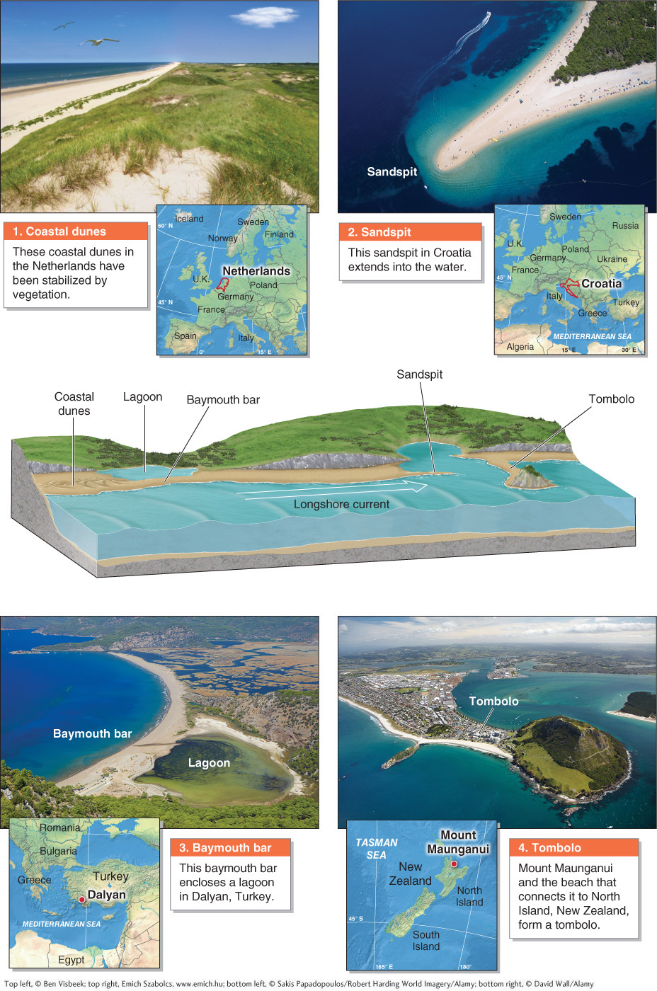
Coastal sand dunes are formed where prevailing winds blow sand inland. Vegetation traps the sand, allowing it to accumulate into dune formations. Through time, many coastal sand dunes become stabilized by vegetation through the process of ecological succession (see Section 7.4).
A sandspit is an elongated dry bar of sand that extends from a beach out into the water, usually parallel with the shore.
sandspit
An elongated dry bar of sand that extends from a beach into the water; usually parallel with the shore.
Page 617A baymouth bar is an unbroken sandspit that forms across the mouth of a river or an estuary. Baymouth bars create an enclosed brackish-
water lagoon behind them and are formed by longshore drift. baymouth bar
A continuous sandspit formed by longshore drift that creates a lagoon of brackish water behind it.
A tombolo is formed when a sandspit connects an island to the mainland. Sandspits, baymouth bars, and tombolos are all formed by longshore drift.
tombolo
A landform consisting of an island and a sandspit that connects it to the mainland.
Another geographically widespread type of depositional coastal landform is a barrier island: an offshore sandbar that runs parallel to the coast. Worldwide, 2,149 barrier islands are recognized. These islands total more than 20,000 km (12,400 mi) in length, representing some 10% of all shorelines on Earth. Antarctica is the only continent without barrier islands. They range in size from a few meters wide and less than a kilometer in length, to several hundred meters wide and hundreds of kilometers in length. They are separated from the mainland by sounds, bays, estuaries, and lagoons (see Section 10.1).
barrier island
An offshore sandbar that runs parallel to the coast.
Barrier-
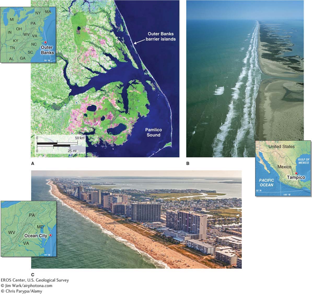
Barrier islands are particularly important to coastal communities because they absorb a significant amount of storm surge and wave energy from tropical cyclones (see Section 5.3). In so doing, they protect the mainland shoreline from the full force of storms.
Human Modification of Beaches
Beaches can lose sand or gain sand overnight during powerful storms that pound them with wave energy. Sand not only drifts “downstream” to other coastal areas, but it also can be removed from the coastal system if it is carried to deeper waters.
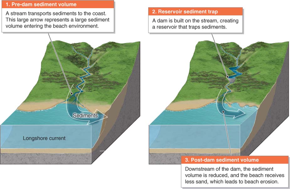
Over time, longshore drift will return sand to the beach, assuming there is an adequate supply of sand feeding into the system from upstream. The sand will not return to a beach, however, if there is an inadequate supply of sand. Recall from Section 15.1 that sand is transported to the coast by streams. Streams flowing into artificial reservoirs drop their sediments in the inland reservoir rather than on the coast. As a result, reservoirs become sediment traps that reduce the volume of sand flowing down a coast, as diagrammed in Figure 19.13.
 Animation
Sand starvation http:/
When streams do not supply a steady input of sediment, beaches become sediment starved, and their sand is lost to erosion. By some estimates, as much as 90% of the beaches in the United States are experiencing net erosion. These losses of sand present problems because beaches protect coastal development from the impact of storm energy, support local coastal economies, and provide habitat for many organisms, including shorebirds and nesting sea turtles. According to the Federal Emergency Management Agency (FEMA), beach erosion due to sea-
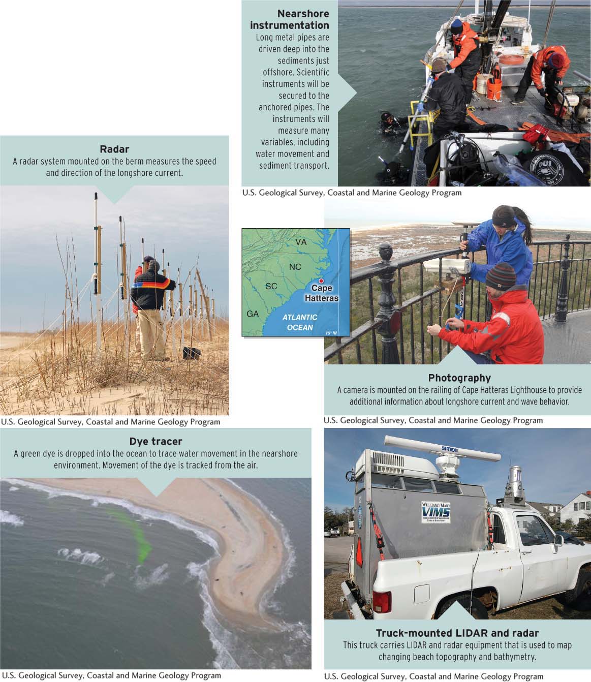
Given the extent of the problem of sand loss and the economic importance of beaches, scientists have developed several means of studying sediment flow on beaches so as to better manage beaches and reduce erosion (Figure 19.14).
One method commonly employed to slow the erosion of sand is the use of groins. A groin is a linear structure made of concrete or stone that extends from a beach into the water (Figure 19.15). Sand moving down the beach will encounter the groin and accumulate against it. A series of groins in a row is called a groin field. Groin fields slow, but do not stop, the loss of sand from a beach.
groin
A linear structure of concrete or stone that extends from a beach into the water, designed to slow the erosion of sand.
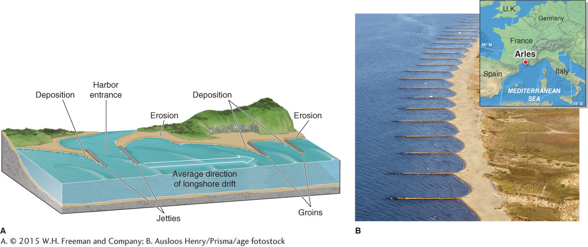
One problem with the use of groins is that they are hard structures that mar the appearance and character of the beach. They also reduce the amount of sand transported downstream to other beaches, which, in turn, become sediment starved. This outcome can result in legal conflicts between beach landholders.
Jetties are artificial walls placed at the mouths of harbors, usually in pairs, to prevent sand from closing the harbor entrance (see Figure 19.15). Without jetties, frequent and costly dredging is required to keep a harbor deep and navigable by boats.
jetty
An artificial wall placed at the mouth of a harbor to prevent sand from closing the harbor entrance; usually placed in pairs.
jetties
Artificial walls placed at the mouth of a harbor to prevent sand from closing the harbor entrance; usually placed in pairs.
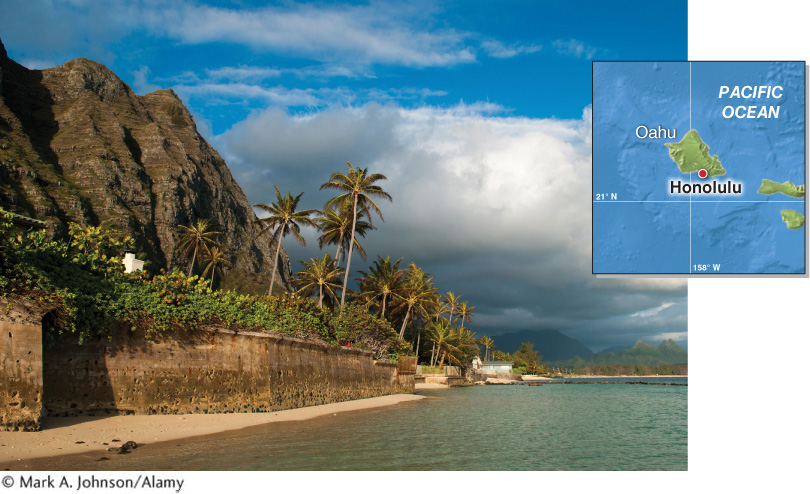
Seawalls are artificial hard structures designed to protect backshore environments from wave erosion during large storms. They are normally concrete or metal walls built parallel to the beach above the intertidal zone. Although they effectively reduce backshore erosion, they can increase the loss of beach sand by reflecting the energy of storm waves, which therefore erode more sand from the beach. They also prevent natural replenishment of backshore dunes with beach sand (Figure 19.16).
seawall
An artificial hard structure designed to protect backshore environments from wave erosion during large storms.
 Another strategy for dealing with beach erosion is the artificial replenishment of sand. The pros and cons of this method are explored further in the Geographic Perspectives at the end of this chapter.
Rocky Coasts
Rocky coasts often have deeper water leading up to the coastline than beaches do. As a result, wave energy is not expended on the seafloor, as it is in most beach environments. Instead, the waves expend the full force of their energy against the rocks, which makes them a powerful and relentless force of erosion in these environments.
Water weighs 1 kg per liter (8.3 lb per gallon) and can be compressed very little. The weight and force of crashing waves pry rocks apart as air and water are forced into even the tiniest joints. In addition to headlands and embayments, described in Section 19.1, three other landforms are commonly found along rocky coastlines (Figure 19.17):
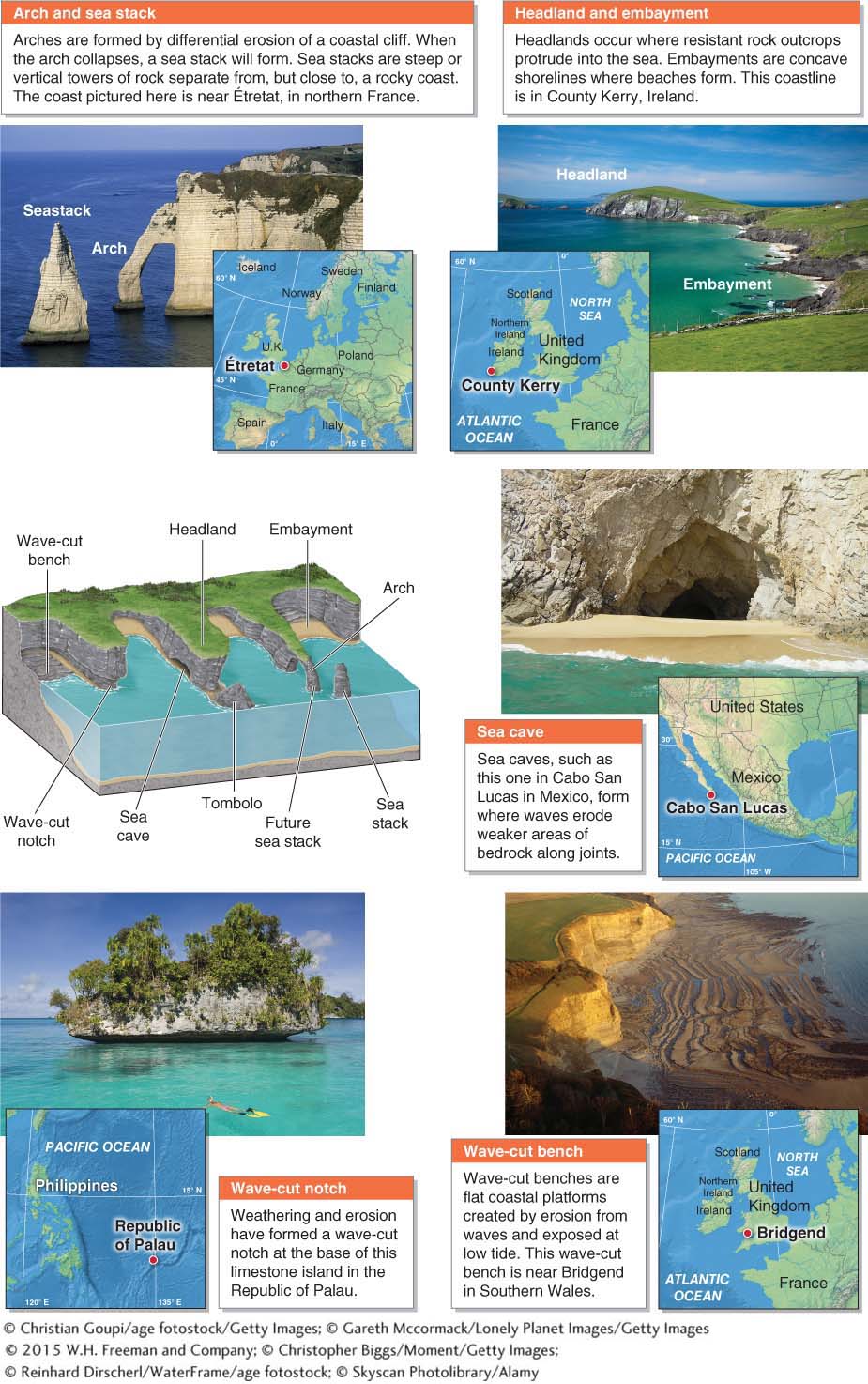
A sea stack is a steep or vertical tower of rock separated from but near a rocky coastal cliff face.
sea stack
A steep or vertical tower of rock separated from but near a rocky coastal cliff face.
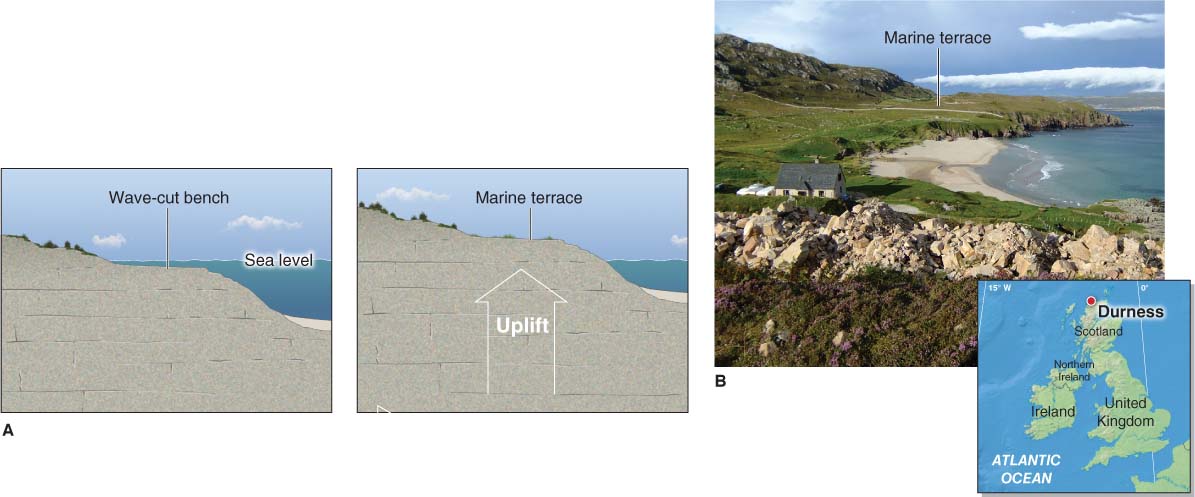
A wave-
cut bench is a flat coastal platform resulting from wave erosion and exposed at low tide.wave-cut bench
A flat coastal platform resulting from wave erosion and exposed at low tide.
A wave-
cut notch is a notch formed at the base of a coastal cliff as a result of weathering and erosion.wave-cut notch
A notch formed at the base of a coastal cliff as a result of weathering and erosion.
On rocky shores, marine terraces indicate the presence of an emergent coastline. A marine terrace is a wave-
marine terrace
A wave-
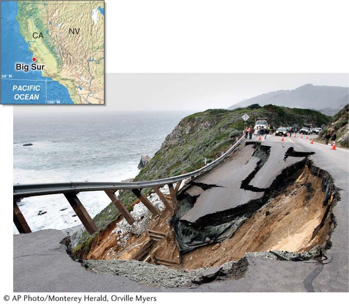
Where a steep coastal cliff is composed of weak rock such as sandstone, the cliff may be undercut and break off in large pieces. Through time, the net result is that the cliff face retreats inland. The coastal cliffs in Big Sur, California, shown in Figure 19.19, have retreated at a rate of about 18 cm (7 in) per year over the last 50 years. Crunch the Numbers explores cliff retreat in Big Sur further.
Animation
Cliff retreat http:/
CRUNCH THE NUMBERS: Calculating Cliff Retreat
CRUNCH THE NUMBERS: Calculating Cliff Retreat
Using 18 cm (7 in) as the average annual rate of cliff retreat in Big Sur, calculate how much total cliff retreat has occurred over the last 50 years.
To calculate the answer, multiply the annual rate of retreat by the number of years of retreat. If you use centimeters, divide by 100 to convert centimeters to meters. If you use inches, divide by 12 to get feet.
Question 19.6
Answer in meters:
Question 19.7
Answer in feet: